ATL: MARCO - Remnants - Discussion
Moderator: S2k Moderators

Re: ATL: FOURTEEN - Tropical Depression - Discussion
Correct me if I’m wrong but it seemed like a lot of the models were showing a weak low crashing into Honduras/ Nicaragua then dissipating and then another low forming north of there.
0 likes
The following post is NOT an official forecast and should not be used as such. It is just the opinion of the poster and may or may not be backed by sound meteorological data. It is NOT endorsed by any professional institution including storm2k.org For Official Information please refer to the NHC and NWS products.

Re: ATL: FOURTEEN - Tropical Depression - Discussion
Maybe a touch off topic, but this is GoM related. Interesting though to say the least.
https://twitter.com/ScotPilie_Wx/status/1296546834362634264
https://twitter.com/ScotPilie_Wx/status/1296516500623433733
https://twitter.com/ScotPilie_Wx/status/1296546834362634264
https://twitter.com/ScotPilie_Wx/status/1296516500623433733
8 likes
-
supercane4867
- Category 5

- Posts: 4966
- Joined: Wed Nov 14, 2012 10:43 am
Re: ATL: FOURTEEN - Tropical Depression - Discussion
The tale of two depressions: race to become Laura
TD14 taking the lead.

TD14 taking the lead.
6 likes
Re: ATL: FOURTEEN - Tropical Depression - Discussion
Frank P wrote:Well the last few vis sat loops hints of building convection near what I perceive as a possible center, and perhaps a hint of a more northerly component as well.. banding In the SE quad also appear to be improving.. all in all not too shabby for a TD in the grand scheme of things...
I just looked at the visible and it sure looks more NNW/NW the NHC track had it sliding over Honduras looks like it might miss it all together..that is if what I saw was the center about 15.5N 81.0W?
Is there multiple vorts?
https://www.weathernerds.org/satellite/ ... nitsst=Off
Last edited by Javlin on Thu Aug 20, 2020 7:09 pm, edited 1 time in total.
2 likes

Re: ATL: FOURTEEN - Tropical Depression - Discussion
GCANE wrote:Maybe a touch off topic, but this is GoM related. Interesting though to say the least.
https://twitter.com/ScotPilie_Wx/status/1296546834362634264
https://twitter.com/ScotPilie_Wx/status/1296516500623433733
I counted 9 but ok that’s pretty darn cool! Never seen anything like that before.
3 likes
Re: ATL: FOURTEEN - Tropical Depression - Discussion
With the PVS gone, this one could get the ball rollin

4 likes

Re: ATL: FOURTEEN - Tropical Depression - Discussion
.tailgater wrote:Correct me if I’m wrong but it seemed like a lot of the models were showing a weak low crashing into Honduras/ Nicaragua then dissipating and then another low forming north of there.
Some did earlier. Some had runs where the lowest pressure might have been over land at the point of output. Most of the recent ones showed it coming up toward the Yucatan via water, so even if the center is close to or on the coast, it should refire east of Central America.
1 likes
-
Frank P
- S2K Supporter

- Posts: 2779
- Joined: Fri Aug 29, 2003 10:52 am
- Location: Biloxi Beach, Ms
- Contact:
Re: ATL: FOURTEEN - Tropical Depression - Discussion
Javelin, the center is close to where GCANE drew his circle
0 likes
Re: ATL: FOURTEEN - Tropical Depression - Discussion
That's why the question about the multiple vorts maybe I had not looked at the NHC for cords just got in from work you know that thing called work Frank or did you finally retire?Anyway that area just seemed to have a lot rotation why I thought it might of been the center? Oh well not the first time to be wrong!
https://www.weathernerds.org/satellite/ ... nitsst=Off
https://www.weathernerds.org/satellite/ ... nitsst=Off
2 likes

Re: ATL: FOURTEEN - Tropical Depression - Discussion
tailgater wrote:Correct me if I’m wrong but it seemed like a lot of the models were showing a weak low crashing into Honduras/ Nicaragua then dissipating and then another low forming north of there.
I don't recall which ones but early on in this system's runs, those solutions were very much what it was showing. But not for a while now.
1 likes
Personal Forecast Disclaimer:
The posts in this forum are NOT official forecast and should not be used as such. They are just the opinion of the poster and may or may not be backed by sound meteorological data. They are NOT endorsed by any professional institution or storm2k.org. For official information, please refer to the NHC and NWS products.
The posts in this forum are NOT official forecast and should not be used as such. They are just the opinion of the poster and may or may not be backed by sound meteorological data. They are NOT endorsed by any professional institution or storm2k.org. For official information, please refer to the NHC and NWS products.
-
gatorcane

- S2K Supporter
- Posts: 23703
- Age: 47
- Joined: Sun Mar 13, 2005 3:54 pm
- Location: Boca Raton, FL
Re: ATL: FOURTEEN - Tropical Depression - Discussion
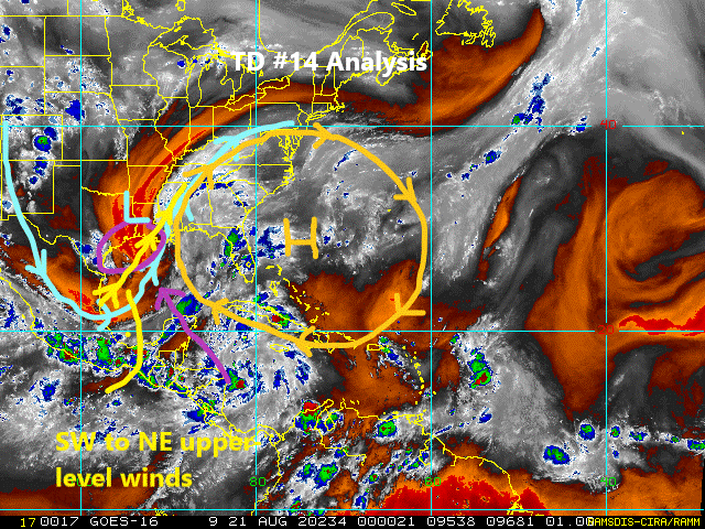
My TD #14 analysis graphic. a TS looks quite possible somewhere in the NW Gulf possibly SE Texas area. Upper-level winds will be decent but not ideal:
1 likes
-
EquusStorm
- Category 5
- Posts: 1649
- Age: 35
- Joined: Thu Nov 07, 2013 1:04 pm
- Location: Jasper, AL
- Contact:
Re: ATL: FOURTEEN - Tropical Depression - Discussion
Could have its best shot east of the Yucatan, but if it stays a while over Honduras it might have to reorganize and won't have as much opportunity. Not that northern Honduras is as mountainous as some areas, but certainly isn't going to help. Nasty flooding risk there.
0 likes
Colors of lost purpose on the canvas of irrelevance
Not a meteorologist, in fact more of an idiot than anything. You should probably check with the NHC or a local NWS office for official information.
Not a meteorologist, in fact more of an idiot than anything. You should probably check with the NHC or a local NWS office for official information.

Re: ATL: FOURTEEN - Tropical Depression - Discussion
gatorcane wrote:My TD #14 analysis graphic. a TS looks quite possible somewhere in the NW Gulf possibly SE Texas area. Upper-level winds will be decent but not ideal:
https://i.postimg.cc/zX2DsPNv/tropical-ge-14km-wv-1.gif
I think it all depends on the strength of the ridge east of Florida and the trough over Texas.
Looks like it could hit the central coast nearer La. and miss Texas altogether. Not a forecast, JM2C
0 likes
-
shiny-pebble
- Category 1

- Posts: 299
- Joined: Thu Jul 05, 2018 1:38 pm
Re: ATL: FOURTEEN - Tropical Depression - Discussion
Is it possible land interaction tightens this up??
Sent from my SM-G970U using Tapatalk
Sent from my SM-G970U using Tapatalk
2 likes
Not an meteorologist! Just someone who is interested in weather. Please refer to the NHC and local weather officials to make decisions.
-Jack
-Jack

Re: ATL: FOURTEEN - Tropical Depression - Discussion
I wasn't expecting this.

0 likes
Igor 2010, Sandy 2012, Fay 2014, Gonzalo 2014, Joaquin 2015, Nicole 2016, Humberto 2019, Imelda 2025
I am only a tropical weather enthusiast. My predictions are not official and may or may not be backed by sound meteorological data. For official information, please refer to the NHC and NWS products.
I am only a tropical weather enthusiast. My predictions are not official and may or may not be backed by sound meteorological data. For official information, please refer to the NHC and NWS products.
Re: ATL: FOURTEEN - Tropical Depression - Discussion
Convention certainly collapsed in the last few hours. It’s already starting to fire back up though so.......
0 likes
The following post is NOT an official forecast and should not be used as such. It is just the opinion of the poster and may or may not be backed by sound meteorological data. It is NOT endorsed by any professional institution including storm2k.org For Official Information please refer to the NHC and NWS products.
-
stormlover2013
Re: ATL: FOURTEEN - Tropical Depression - Discussion
Kazmit wrote:I wasn't expecting this.
https://img.techpowerup.org/200821/025457-5day-cone-no-line-and-wind.png
What ??
0 likes
-
CrazyC83
- Professional-Met

- Posts: 34308
- Joined: Tue Mar 07, 2006 11:57 pm
- Location: Deep South, for the first time!
Re: ATL: FOURTEEN - Tropical Depression - Discussion
With the 32 kt buoy report (adjusted) it is very close to storm status. This should become Laura, since TD13 may not even be closed right now.
1 likes
-
Hypercane_Kyle

- Category 5
- Posts: 3465
- Joined: Sat Mar 07, 2015 7:58 pm
- Location: Cape Canaveral, FL
Re: ATL: FOURTEEN - Tropical Depression - Discussion
Worth noting, from Stewart at 11:00 PM EDT.
By
120 hours, the GFS- and ECMWF-based SHIPS models show the vertical
wind shear increasing sharply from the southwest to 20-25 kt, which
would normally induce weakening. However, it appears that those
models are incorporating some strong jetstream winds of 60-70 kt
well to the northwest of the center of the cyclone, which has
resulted in high bias in the shear output. Therefore, the cyclone
is forecast to be near hurricane strength when it approaches the
Texas coast in 120 hours.
4 likes
My posts are my own personal opinion, defer to the National Hurricane Center (NHC) and other NOAA products for decision making during hurricane season.
-
Nederlander
- S2K Supporter
- Posts: 1252
- Joined: Sat Jul 19, 2008 4:28 pm
- Location: Conroe, TX
Re: ATL: FOURTEEN - Tropical Depression - Discussion
Kazmit wrote:I wasn't expecting this.
https://img.techpowerup.org/200821/025457-5day-cone-no-line-and-wind.png
Whoa...
Kudos to the NHC for also acknowledging the models have been trash this year.
1 likes
Who is online
Users browsing this forum: No registered users and 40 guests