GCANE wrote:Tower is tightening up the eyewall
Likely a pinhole in 24 hrs.
https://metservice.gov.jm/daily-forecast/radar/
Can you post the radar image for me? I can't see it for some reason
Moderator: S2k Moderators


GCANE wrote:Tower is tightening up the eyewall
Likely a pinhole in 24 hrs.
https://metservice.gov.jm/daily-forecast/radar/


ScottNAtlanta wrote:Radar is showing a west movement
https://zoom.earth/places/jamaica/#map=radar

MHC Tracking wrote:cheezyWXguy wrote:I’m not sold on the contraction to pinhole eye though, that eye looks about average sized. Good news is that probably means a Milton or Wilma-level explosion isn’t as likely, but bad news is a larger core won’t collapse as quickly into an ewrc upon reaching peak. Could still undergo one, but would probably stabilize for a while first. Won’t matter much either way though, it’s hard to bet against a cat5 peak at this point so Jamaica better be taking this seriously
I'm not "downcasting" but I remain a bit doubtful of a Cat 5 peak. Downsloping from Jamaica has interfered with the development of hurricanes in the past (see: Grace 2021), it feels possible that it does so here as well.


USTropics wrote:MHC Tracking wrote:cheezyWXguy wrote:I’m not sold on the contraction to pinhole eye though, that eye looks about average sized. Good news is that probably means a Milton or Wilma-level explosion isn’t as likely, but bad news is a larger core won’t collapse as quickly into an ewrc upon reaching peak. Could still undergo one, but would probably stabilize for a while first. Won’t matter much either way though, it’s hard to bet against a cat5 peak at this point so Jamaica better be taking this seriously
I'm not "downcasting" but I remain a bit doubtful of a Cat 5 peak. Downsloping from Jamaica has interfered with the development of hurricanes in the past (see: Grace 2021), it feels possible that it does so here as well.
We we will need six things to achieve maximum potential intensity (MPI) here (a real possibility), I'll list it from very likely -> unknown:
1) High OHC (obvious we have this)
2) Wind shear to decrease to > 10kt (very likely)
3) Subsidence/dry air entrainment to be minimal (very likely)
4) Efficient outflow to rapidly advect updrafted air away (likely)
5) A pinhole eye to sustain RI to cat 5 (unknown, only mesoscale models can parameterize this)
6) Like you stated, it needs to stay far enough south of Jamaica to not have inflow disrupted (uncertain)
The NHC is following the consensus models (particularly HCCA) and hedging towards the Google DeepMind/EAIFS ensemble tracks currently (they've done shockingly well this year). Looking at mesoscale models that are following this track currently, HAFS-A again has the most accurate run at 12z:
https://i.imgur.com/9dgtsNI.png
HAFS-B has its peak at the same time, but more to the north in location:
https://i.imgur.com/rVLVqBm.png
HMON is similar to HAFS-B
https://i.imgur.com/tdL3qjo.png
I'm not buying the HWRF, as it's track is far too quick (landfall already tomorrow evening in Jamaica):
https://i.imgur.com/RnFgpIR.png
Again, I think the HAFS-A has done really well with the structural changes and speed of Melissa, and is supported by the best performing consensus model and the AI ensemble suite. I think RI is almost certain imo and Cat 4/5 is a real possibility depending on that initial structure (i.e., no EWRC and ability for radial winds to refine a pinhole eye structure).
https://i.imgur.com/KhP5z5D.gif


Pelicane wrote:
https://i.imgur.com/jUbxyTc.jpeg


2:00 PM EDT Sat Oct 25
Location: 16.6°N 75.2°W
Moving: WNW at 1 mph
Min pressure: 980 mb
Max sustained: 75 mph


Blown Away wrote:2:00 PM EDT Sat Oct 25
Location: 16.6°N 75.2°W
Moving: WNW at 1 mph
Min pressure: 980 mb
Max sustained: 75 mph
.1 degree N of 11am and was predicted to move .1 degrees S before W turn. May change angle towards Jamaica?


Pelicane wrote:The 12z HAFS-B and A solution would be near-worst case scenarios for the Kingston area, with the core either just to the left or into the harbor.
Also, I did not know that Kingston's international airport is essentially in the middle of the harbor. Seems like a pretty bad place for an airport.
https://i.imgur.com/IAXAuMs.png
https://i.imgur.com/pM4efzy.png
https://i.imgur.com/jUbxyTc.jpeg
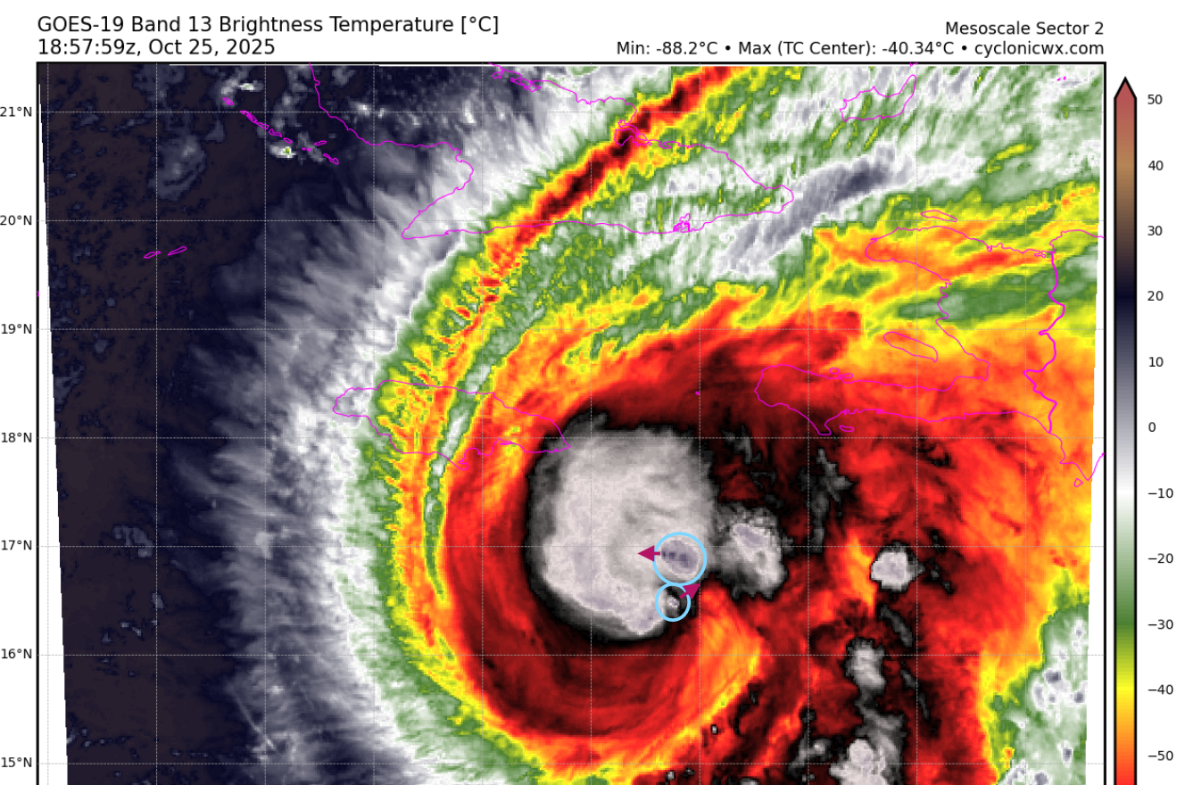
Iceresistance wrote:I think Melissa has gotten the dual VHTs, the arrows are direction. The northern VHT is moving fast
https://s12.gifyu.com/images/b3n30.png
https://s12.gifyu.com/images/b3n30.png

Teban54 wrote:Iceresistance wrote:I think Melissa has gotten the dual VHTs, the arrows are direction. The northern VHT is moving fast
https://s12.gifyu.com/images/b3n30.png
https://s12.gifyu.com/images/b3n30.png
Now it looks like there are even 3 hot towers:
https://i.imgur.com/UJ1rnpo.gif
Users browsing this forum: No registered users and 51 guests


