ATL: Tropical Depression Fay

Moderator: S2k Moderators

Message
Author
User avatar
HURAKAN
Professional-Met
Professional-Met
Posts: 46086
Age: 38
Joined: Thu May 20, 2004 4:34 pm
Location: Key West, FL
Contact:

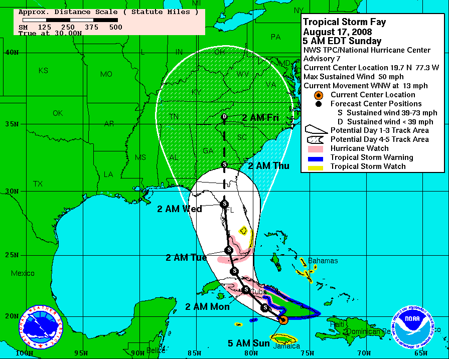
#6261 Postby HURAKAN » Sun Aug 17, 2008 9:48 am

Image

Image

A shift to the east on the latter forecast points.
0 likes   

Sanibel
Category 5
Category 5
Posts: 10385
Joined: Mon Aug 30, 2004 11:06 pm
Location: Offshore SW Florida

Re: ATL: Tropical Storm Fay South of Cuba

#6262 Postby Sanibel » Sun Aug 17, 2008 9:48 am

42 hours straight of a track right across Sanibel. :roll:


Worse approach angle for intensity.
Last edited by Sanibel on Sun Aug 17, 2008 9:52 am, edited 2 times in total.
0 likes   

cpdaman
Category 5
Category 5
Posts: 3131
Joined: Sat Jun 10, 2006 11:44 am
Location: SPB county (gulf stream)

Re: ATL: Tropical Storm Fay South of Cuba

#6263 Postby cpdaman » Sun Aug 17, 2008 9:48 am

i think one could look at the loops and see the ULL to the west had a hand in the poor organization/ convectionless left side

http://www.ssd.noaa.gov/goes/east/gmex/loop-wv.html

what's going on with ull is it moving west yet expanding at the same time? is it not that big of a deal, what's the reason for the poor convection (actually there are barely clouds) on the west side?
0 likes   

User avatar
johngaltfla
Category 5
Category 5
Posts: 2072
Joined: Sun Jul 10, 2005 9:17 pm
Location: Sarasota County, FL
Contact:

Re:

#6264 Postby johngaltfla » Sun Aug 17, 2008 9:49 am

wxwonder12 wrote:Did the NHC change at all the forcast point of entering florida on their 5 day cone map at all?


It has just drifted back south to the Ft. Myers area again. It has been up and down between Venice and Bonita Beach for two days now. I would ignore the line and focus more on the course after it crosses Cuba. This is the time to begin implementing your hurricane plan now if you are in the watch area.
0 likes   

JPmia
S2K Supporter
S2K Supporter
Posts: 1070
Joined: Thu Jun 03, 2004 11:01 pm
Location: Fort Lauderdale, FL

#6265 Postby JPmia » Sun Aug 17, 2008 9:49 am

at 11am NHC expects landfall around the Ft. Myers area (emphasis on "area" added of course) as a Cat 1
0 likes   

jaxfladude
Category 5
Category 5
Posts: 1249
Joined: Wed Aug 24, 2005 9:36 pm
Location: Jacksonville, Fla

Re: ATL: Tropical Storm Fay South of Cuba

#6266 Postby jaxfladude » Sun Aug 17, 2008 9:50 am

Wow my area(Jax, Fla) may just get some nasty affects of Fay after all...hope not too badly though...
0 likes   

User avatar
NDG
S2K Supporter
S2K Supporter
Posts: 15507
Joined: Sun Jul 09, 2006 10:14 pm
Location: Orlando, FL

#6267 Postby NDG » Sun Aug 17, 2008 9:51 am

I think that area of convection moving away from Jamaica is what robbed some of the southerly inflow to Fay early during the morning, might had been caused by the topography of Jamaica, thus the convection decrease near Fay's LLC besides the high mountainous coastal area in Cuba it encountered earlier in the morning that did not helped it wrap around the moisture.
0 likes   

Sanibel
Category 5
Category 5
Posts: 10385
Joined: Mon Aug 30, 2004 11:06 pm
Location: Offshore SW Florida

Re: ATL: Tropical Storm Fay South of Cuba

#6268 Postby Sanibel » Sun Aug 17, 2008 9:51 am

Could be entering the periphery of the High and slowly increasing in forward speed.
0 likes   

User avatar
robbielyn
Category 5
Category 5
Posts: 1299
Joined: Wed May 07, 2003 9:45 am
Location: brooksville, fl

#6269 Postby robbielyn » Sun Aug 17, 2008 9:52 am

Ok seems to me with a small hurricane wind field it looks like again tampa will dodge a bullet. the shield remains in place. it will barely be a cat 1 if that. like i said just an inconvenient storm for my area. sorry sanibel a little more serious for you down there.
0 likes   

User avatar
johngaltfla
Category 5
Category 5
Posts: 2072
Joined: Sun Jul 10, 2005 9:17 pm
Location: Sarasota County, FL
Contact:

Re: ATL: Tropical Storm Fay South of Cuba

#6270 Postby johngaltfla » Sun Aug 17, 2008 9:52 am

cpdaman wrote:i think one could look at the loops and see the ULL to the west had a hand in the poor organization/ convectionless left side

http://www.ssd.noaa.gov/goes/east/gmex/loop-wv.html

what's going on with ull is it moving west yet expanding at the same time? is it not that big of a deal, what's the reason for the poor convection (actually there are barely clouds) on the west side?


Dr. Steve Lyons basically said that as the ULL moves to the SW that it should intensify some. They are not sure just how strong the storm it will be until it crosses Cuba.

It does have time this afternoon though to get its act together before crossing Cuba. Hopefully it stays weak and crosses into the GOM as a TD. We do not need a hurricane here now.
0 likes   

Terry
S2K Supporter
S2K Supporter
Posts: 1450
Joined: Wed Aug 11, 2004 8:25 pm
Location: Lakeland and Anna Maria Island, FL
Contact:

Re:

#6271 Postby Terry » Sun Aug 17, 2008 9:54 am

robbielyn wrote:Ok seems to me with a small hurricane wind field it looks like again tampa will dodge a bullet. the shield remains in place. it will barely be a cat 1 if that. like i said just an inconvenient storm for my area. sorry sanibel a little more serious for you down there.


You're a bit premature to let your guard down.
0 likes   

cpdaman
Category 5
Category 5
Posts: 3131
Joined: Sat Jun 10, 2006 11:44 am
Location: SPB county (gulf stream)

Re:

#6272 Postby cpdaman » Sun Aug 17, 2008 9:55 am

NDG wrote:I think that area of convection moving away from Jamaica is what robbed some of the southerly inflow to Fay early during the morning, might had been caused by the topography of Jamaica, thus the convection decrease near Fay's LLC besides the high mountainous coastal area in Cuba it encountered earlier in the morning that did not helped it wrap around the moisture.


you think she might get some better southerly inflow now?
0 likes   

User avatar
johngaltfla
Category 5
Category 5
Posts: 2072
Joined: Sun Jul 10, 2005 9:17 pm
Location: Sarasota County, FL
Contact:

Re:

#6273 Postby johngaltfla » Sun Aug 17, 2008 9:56 am

robbielyn wrote:Ok seems to me with a small hurricane wind field it looks like again tampa will dodge a bullet. the shield remains in place. it will barely be a cat 1 if that. like i said just an inconvenient storm for my area. sorry sanibel a little more serious for you down there.


IF you are wrong and it does ride the ridge up the coastline your neck of the woods will get the worse. Keep in mind the storm had been predicted at many points to head up towards the Big Bend area. I would review my plans at a minimum.
0 likes   

User avatar
robbielyn
Category 5
Category 5
Posts: 1299
Joined: Wed May 07, 2003 9:45 am
Location: brooksville, fl

Re: Re:

#6274 Postby robbielyn » Sun Aug 17, 2008 9:58 am

Terry wrote:
robbielyn wrote:Ok seems to me with a small hurricane wind field it looks like again tampa will dodge a bullet. the shield remains in place. it will barely be a cat 1 if that. like i said just an inconvenient storm for my area. sorry sanibel a little more serious for you down there.


You're a bit premature to let your guard down.


No I am not. there is a reason why these storms either hit naples or the panhandle as hurricanes and ts in our area. And just because i let my guard down, doesn't mean others have to. But it's not going to be a big deal here in this particular area except those low lying areas and high tide flooding trailer parks. I do feel for them folks. A ts gives them the flooding doesn't have to be bad but if all the convection remains mostly to the east we will dodge a bullet. With charley and gordon we had sunshine.
0 likes   

User avatar
AdamFirst
S2K Supporter
S2K Supporter
Posts: 2490
Age: 36
Joined: Thu Aug 14, 2008 10:54 am
Location: Port Saint Lucie, FL

#6275 Postby AdamFirst » Sun Aug 17, 2008 9:59 am

Looks like on the visible satellite that Fay is trying to get her act together...some convection is building near the center

For a storm that has so much opportunity to develop it's certainly not doing so...perhaps we should be thankful :wink:
0 likes   

Sanibel
Category 5
Category 5
Posts: 10385
Joined: Mon Aug 30, 2004 11:06 pm
Location: Offshore SW Florida

Re: ATL: Tropical Storm Fay South of Cuba

#6276 Postby Sanibel » Sun Aug 17, 2008 9:59 am

I thought that surface feature was a satellite vortex it looked so weak. If that is the center it has increased in forward speed and is well displaced. This will stay weak for now. Which adds to the problem of underestimating Fay once it gets that ULL to its SW over the Gulf Stream.
0 likes   

JPmia
S2K Supporter
S2K Supporter
Posts: 1070
Joined: Thu Jun 03, 2004 11:01 pm
Location: Fort Lauderdale, FL

#6277 Postby JPmia » Sun Aug 17, 2008 10:00 am

just as an FYI - local South Florida NWS site has some nice graphics of local impacts down here:

http://www.srh.noaa.gov/mfl/ghls/
0 likes   

User avatar
SouthFLTropics
Category 5
Category 5
Posts: 4258
Age: 50
Joined: Thu Aug 14, 2003 8:04 am
Location: Port St. Lucie, Florida

Re:

#6278 Postby SouthFLTropics » Sun Aug 17, 2008 10:02 am

AdamFirst wrote:Looks like on the visible satellite that Fay is trying to get her act together...some convection is building near the center

For a storm that has so much opportunity to develop it's certainly not doing so...perhaps we should be thankful :wink:


That is definitely the truth. Fay has had probably about the best upper air pattern that a storm could have since her inception but she has loved hanging around land. Maybe she is shy about getting her feet wet.

BTW, hello fellow poster from PSL...

SFT
0 likes   

User avatar
robbielyn
Category 5
Category 5
Posts: 1299
Joined: Wed May 07, 2003 9:45 am
Location: brooksville, fl

Re: Re:

#6279 Postby robbielyn » Sun Aug 17, 2008 10:02 am

johngaltfla wrote:
robbielyn wrote:Ok seems to me with a small hurricane wind field it looks like again tampa will dodge a bullet. the shield remains in place. it will barely be a cat 1 if that. like i said just an inconvenient storm for my area. sorry sanibel a little more serious for you down there.


IF you are wrong and it does ride the ridge up the coastline your neck of the woods will get the worse. Keep in mind the storm had been predicted at many points to head up towards the Big Bend area. I would review my plans at a minimum.


Well i live 10 miles east from the coast of hernando beach. I rent a room from my landlady who guess what has no plywood or storm shutters. But that is ok. I will be called to hang out at the hospital where i work if a hurricane comes. if its a ts then i can just work my regular shift. I know things can change on a dime but this is too predictable and goes against the odds of the riding straight up the coast. There is a reason the models are shifting east which is more typical. So I am minimally prepared but I am far from feeling like this is going to be a big deal for my area. After it crosses cuba then I will let you all know if my gut feeling is accurate or deceiving me.
0 likes   

jaxfladude
Category 5
Category 5
Posts: 1249
Joined: Wed Aug 24, 2005 9:36 pm
Location: Jacksonville, Fla

Re: ATL: Tropical Storm Fay South of Cuba

#6280 Postby jaxfladude » Sun Aug 17, 2008 10:05 am

Sanibel wrote:I thought that surface feature was a satellite vortex it looked so weak. If that is the center it has increased in forward speed and is well displaced. This will stay weak for now. Which adds to the problem of underestimating Fay once it gets that ULL to its SW over the Gulf Stream.

Are you thinking that Fay may just yet be a stronger than forecast TS/Hurricane at this point when Fay makes it's SW/W Florida landfall...?
0 likes   


Return to “2008”

Who is online

Users browsing this forum: No registered users and 53 guests