Florida Weather
Moderator: S2k Moderators
Forum rules

The posts in this forum are NOT official forecast and should not be used as such. They are just the opinion of the poster and may or may not be backed by sound meteorological data. They are NOT endorsed by any professional institution or STORM2K.
-
gatorcane

- S2K Supporter

- Posts: 23708
- Age: 48
- Joined: Sun Mar 13, 2005 3:54 pm
- Location: Boca Raton, FL
I see a line of building cumulus about 12 miles east of the coastline from hernando county south to Sarasota. That must be where the west coast seabreeze is meeting the east wind flow. But the thunderstorm development seems confined to the south over Sarasota county.
Looking south into Southern Florida and the Florida Keys, deep tropical moisture is so close yet looks like the bulk of it is slipping by to the east. Southwest wind shear continues to blow off the cloud tops to the northeast, courtesy if a stubborn upper-level low sitting over the eastern Gulf of Mexico.
This scenario is exactly what I was worried about several days ago, as we were watching 94L in the Western Caribbean sea - that most of the good moisture and much needed rains would impact central and eastern Cuba and move over I to the Bahamas, missing Florida to the east.
But the good news is that those areas are also getting much need rains.
0 likes
-
AdamFirst

- S2K Supporter
- Posts: 2490
- Age: 36
- Joined: Thu Aug 14, 2008 10:54 am
- Location: Port Saint Lucie, FL
East coast remains dry aside from a few fast moving showers off the Atlantic around Palm Beach County and the middle Keys...
Huge swath of rain from ex-94L is well offshore heading towards Andros Island.
Huge swath of rain from ex-94L is well offshore heading towards Andros Island.
0 likes
Dolphins Marlins Canes Golden Panthers HEAT
Andrew 1992 - Irene 1999 - Frances 2004 - Jeanne 2004 - Wilma 2005 - Fay 2008 - Isaac 2012 - Matthew 2016 - Irma 2017 - Dorian 2019 - Ian 2022 - Nicole 2022 - Milton 2024
Andrew 1992 - Irene 1999 - Frances 2004 - Jeanne 2004 - Wilma 2005 - Fay 2008 - Isaac 2012 - Matthew 2016 - Irma 2017 - Dorian 2019 - Ian 2022 - Nicole 2022 - Milton 2024

Re: Re:
thetruesms wrote:That's actually the High Resolution Rapid Refresh, which is different from the RUC (though they fill the same niche).NDG wrote:11z RUC shows a nice surge of moisture to head over S FL today, showing scattered to widespread showers.
[img]http://rapidrefresh.noaa.gov/hrrrconus/from_jet/hrrr/t6/2011060911/cref_t6sfc_f08.png[img]
Also, while moisture does look to be increasing, the composite reflectivity isn't necessarily the best product to be looking for rainfall, particularly if it'll be light. For example, take a look at the corresponding accumulated rainfall graphic for the same time:
What I think is happening, is that what's showing up in the composite reflectivity graphic is fairly high up, and evaporating in the relative dry low-mid levels, which you can see in the wide spread between the temperature and dewpoint profiles here:
Even when you look at the max 1km reflectivity, you can see that what's closer to the ground is relatively limited
But, like the Miami AFD from last night said, "Hey . . . at least it's a start"


Yeah, I noticed later that the composite reflectivity graphics was over doing it because the its rainfall forecast was showing less a tenth of an inch at the most.
0 likes
-
JonathanBelles
- Professional-Met

- Posts: 11430
- Age: 35
- Joined: Sat Dec 24, 2005 9:00 pm
- Location: School: Florida State University (Tallahassee, FL) Home: St. Petersburg, Florida
- Contact:
http://wp.me/p1xnuB-1O
Some rain finally along the west coast, a mention of 94L, and the animals that begin coming out this time of year.
Some rain finally along the west coast, a mention of 94L, and the animals that begin coming out this time of year.
0 likes
-
Rgv20

- S2K Supporter
- Posts: 2466
- Age: 39
- Joined: Wed Jan 05, 2011 5:42 pm
- Location: Edinburg/McAllen Tx
The Battle between the NAM and GFS regarding rain in Florida.
0z6/10/2011 GFS with some good widespread rain mainly in the southern half of the state.
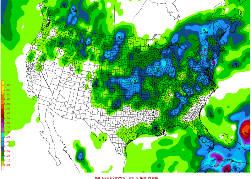
0z6/10/2011 NAM with most of the Rain to the east of the peninsula.
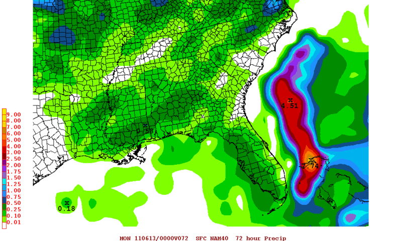
0z6/10/2011 GFS with some good widespread rain mainly in the southern half of the state.
0z6/10/2011 NAM with most of the Rain to the east of the peninsula.
0 likes
The following post is NOT an official forecast and should not be used as such. It is just the opinion of the poster and may or may not be backed by sound meteorological data. It is NOT endorsed by any professional institution including storm2k.org For Official Information please refer to the NHC and NWS products.

-
gatorcane
- S2K Supporter
- Posts: 23708
- Age: 48
- Joined: Sun Mar 13, 2005 3:54 pm
- Location: Boca Raton, FL
More light-heartedness by our friends at NWS Miami. It is amazing how we cannot get any good rain here in South Florida and we are approaching mid June, our wettest month. The lawn in my neighborhood is torched and some mature trees are literally gradually dieing due to lack of rain.....had to water some in my yard today....
000
FXUS62 KMFL 110203
AFDMFL
AREA FORECAST DISCUSSION
NATIONAL WEATHER SERVICE MIAMI FL
1003 PM EDT FRI JUN 10 2011
.UPDATE...A SURFACE TROUGH IS SITUATED OFF TO OUR
SOUTHEAST...STRETCHING FROM ACROSS CUBA TO THE BAHAMAS. WINDS
CONTINUE RATHER FAST OUT OF THE NORTHEAST DUE TO THE PRESSURE
GRADIENT BETWEEN THE TROUGH AND THE HIGH TO THE NORTH. MOISTURE
HAS FINALLY INCREASED WITH PRECIPITABLE WATER ON THE EVENING MIAMI
SOUNDING AT A HEALTHY 1.98 INCHES (ACTUALLY ABOVE NORMAL!)...AND
THERE IS VERY GOOD LOW LEVEL MOISTURE. SO DESPITE NO SHOWERS OVER
THE ATLANTIC AS OF THIS WRITING (WHICH IS A BIT PERPLEXING...THE
ATMOSPHERE JUST DOESN`T WANT TO LET GO OF THE DROUGHT!)...AM
EXPECTING A FEW SHOWERS TO DEVELOP OVER THE ATLANTIC WITH MOVEMENT
ONSHORE THE EAST COAST...SO WILL MAINTAIN 20 POPS EAST COAST. NO
SIGNIFICANT CHANGES WERE MADE TO THE FORECAST THIS EVENING.
/GREGORIA
http://forecast.weather.gov/product.php ... glossary=1
0 likes

Re: Florida Weather Thread: Beginning of the rainy season?
Latest Drought monitor - “exceptional” drought conditions are spreading across South Florida, a designation that South Florida has never seen before, according to the National Weather Service in Miami.
Rainfall deficits since October 1, 2010:
West Palm Beach: 24.40" below normal (31% of average rainfall)
Fort Lauderdale: 26.29" below normal (26% of average rainfall)
Rainfall deficits since January 1, 2011:
West Palm Beach: 15.07" below normal (30% of average rainfall)
Fort Lauderdale: 17.82" below normal (19% of average rainfall)
0 likes
Re: Florida Weather Thread: Beginning of the rainy season?
After smoky morning in the Miami area, hopefully we will see at least pretty good chances for rain east coast areas this pm:
NATIONAL WEATHER SERVICE MIAMI FL
817 AM EDT SAT JUN 11 2011
.UPDATE...
THE SHORT TERM FORECAST WAS UPDATED TO INCLUDE AREAS OF SMOKE FOR
THE TWO BRUSH FIRES IN WEST CENTRAL MIAMI DADE COUNTY. EARLY THIS
MORNING THE SURFACE WINDS ACROSS MOST OF THE EASTERN HALF OF THE
SOUTH FLORIDA BECAME NORTHWEST AND LIGHT...ESPECIALLY IN THE AREA
SURROUNDING THE FIRES...WHICH THEN BROUGHT SMOKE INTO THE MUCH OF
THE MIAMI DADE METRO AREA. HOPEFULLY THE ESTABLISHMENT OF THE EAST
COAST SEA BREEZE LATE THIS MORNING AND ANY SHOWER ACTIVITY MAY
HELP TO ALLEVIATE THE CURRENT SMOKEY CONDITIONS ACROSS THE MIAMI
METRO AREA.
SHORT TERM...TODAY...MODELS IN GENERAL AGREEMENT SHOWING THE LOW
LEVEL TROUGH MOVING NORTHWARD ACROSS SOUTH FLORIDA TODAY WHILE THE
UPPER LOW/TROUGH SLOWLY INCHES EASTWARD. THIS SITUATION SHOULD NOT
ONLY PROVIDE A GOOD LIFTING MECHANISM AND INCREASING MOISTURE AS
THE BOUNDARY MOVES THROUGH THE AREA, BUT SHOULD ALSO PUT SOUTH
FLORIDA UNDER A GOOD DIVERGENT FLOW ALOFT. WITH ALL THESE
INGREDIENTS AND FACTORS, WILL EXPECT CONVECTIVE ACTIVITY THIS
AFTERNOON, YET BOTH MAV AND MET INDICATE RATHER LOW POPS FOR
TODAY. GFS, HOWEVER, SHOWS INCREASED COVERAGE OVER INLAND AREAS.
WL GO CLOSER TO GFS AND INDICATE A GOOD CHANCE OF SHOWERS/TSTMS
OVER INLAND AREAS, HOWEVER WL GO WITH SLIGHTLY HIGHER POPS OVER
EAST COAST. BELIEVE SOUTHWESTERLY FLOW ALOFT WILL TEND TO STEER
ANY SHOWER/STORM NORTHEASTWARD.
0 likes
-
gatorcane
- S2K Supporter
- Posts: 23708
- Age: 48
- Joined: Sun Mar 13, 2005 3:54 pm
- Location: Boca Raton, FL
We cannot buy rain around here. NWS Miami already lowering POPS for today:
000
FXUS62 KMFL 111418
AFDMFL
AREA FORECAST DISCUSSION
NATIONAL WEATHER SERVICE MIAMI FL
1018 AM EDT SAT JUN 11 2011
.UPDATE...
UPDATED SHORT TERM FORECAST FOR EXPECTED WEATHER THIS AFTERNOON.
THE MOST RECENT GUIDANCE REDUCED POPS ACROSS THE REGION AND SEEMS
REASONABLE GIVEN CURRENT SYNOPTIC CONDITIONS. SO MORE ISOLATED
SHOWER AND THUNDERSTORM ACTIVITY EXPECTED ALONG THE COASTAL ZONES
WITH MORE SCATTERED ACTIVITY EXPECTED IN THE INTERIOR AND WESTERN
INTERIOR. BOTH THE WEST AND EAST COAST SEA BREEZE DEVELOPMENT WILL
BE DELAYED DUE TO THE CURRENT SYNOPTIC FLOW ACROSS THE REGION. THE
12Z SOUNDING INDICATED THE PWAT DECREASED TO ABOUT 1.7 INCHES.
SOUNDING ANALYSIS INDICATES THAT A FEW ISOLATED STRONG
THUNDERSTORMS MAY BE POSSIBLE WITH CONVECTION LATER THIS
AFTERNOON...WITH DOWN DRAFT WINDS TO NEAR 55 MPH POSSIBLE IN THE
STRONGEST THUNDERSTORMS.
http://forecast.weather.gov/product.php ... glossary=1
0 likes
-
Scorpion
i don't think florida is becoming more arid. Florida is actually a fairly wet place when you look at long term averages. in peninsular florida, we have a distinct rainy season and most of our precip is convective in nature. the net effect is we have enormous extremes in our precipitation distribution with prolonged "feast or famine" episodes. last august i had 15.5" of rain. two months later in october not a single drop fell. in march 2011 i had over a foot of rain, most of which fell during two episodes in the last week of the month. very little rain has fallen here since that event over two month ago.
0 likes
-
dolebot_Broward_NW
- Category 2

- Posts: 529
- Joined: Fri Sep 10, 2004 6:38 am
Re: Florida Weather Thread: Beginning of the rainy season?
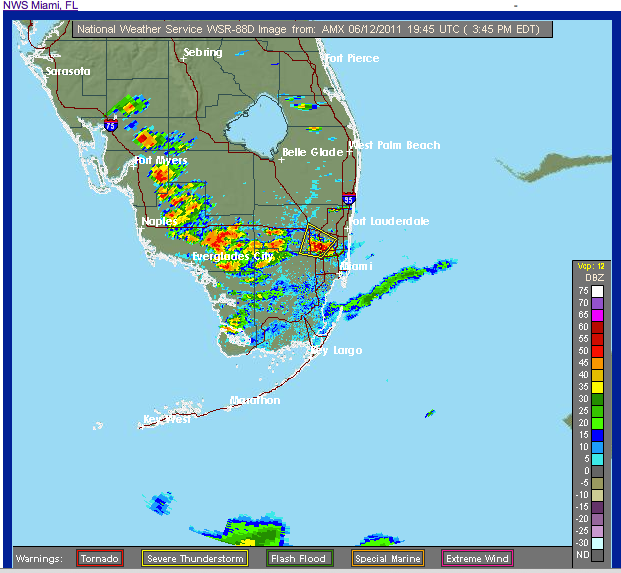
STW for Central Broward as a SB initiated storm moves up from us27/krome up into west Broward. Looking FINE on radar, I think this is the first real "rainy season" day. We've noticed a significant increase in humidity over the weekend and the soundings prove it:
12Z MIA SOUNDING (06/12/11) EQUIL LEVEL 46998, CAPE 3872, PWAT 2.06
PWAT up over 2", last week it was under 1.3". That CAPE is remarkable and the dryness in the upper atmosphere is mostly gone.
Right now its pouring rain in most of the Everglades as you can see on radar:
12Z MIA SOUNDING (06/12/11) EQUIL LEVEL 46998, CAPE 3872, PWAT 2.06
PWAT up over 2", last week it was under 1.3". That CAPE is remarkable and the dryness in the upper atmosphere is mostly gone.
Right now its pouring rain in most of the Everglades as you can see on radar:
0 likes
-
gatorcane
- S2K Supporter
- Posts: 23708
- Age: 48
- Joined: Sun Mar 13, 2005 3:54 pm
- Location: Boca Raton, FL
Finally. Big thunderstorms are blowing up over the Everglades and pushing NE...into metro SE Florida. West Coast of Florida is quite dry especially north of Sarasota.....this finally looks like the first day the rainy season has started here.
I am crossing my fingers those big thunderstorms will impact the metro West Palm Beach area....
I am crossing my fingers those big thunderstorms will impact the metro West Palm Beach area....
0 likes
Return to “USA & Caribbean Weather”
Who is online
Users browsing this forum: No registered users and 49 guests