ATL: TROPICAL DEPRESSION DANNY (05L)
Moderator: S2k Moderators
-
wxman57

- Moderator-Pro Met

- Posts: 23168
- Age: 68
- Joined: Sat Jun 21, 2003 8:06 pm
- Location: Houston, TX (southwest)
Re: ATL: Invest 92L
Looks like a tropical wave axis with moderately strong winds near the crest in that convection. There's a tight pressure gradient between the 1012mb pressure at the buoy near 21N and the other buoys around 27N with 1018-1020mb. Tomorrow.
Last edited by wxman57 on Tue Aug 25, 2009 6:06 pm, edited 1 time in total.
0 likes
-
HURAKAN

- Professional-Met

- Posts: 46086
- Age: 38
- Joined: Thu May 20, 2004 4:34 pm
- Location: Key West, FL
- Contact:
Re: ATL: Invest 92L

A tropical low pressure system centered about 250 miles north of Puerto Rico Tuesday afternoon threatens to become the fourth tropical storm of the season within the next 36 hours. All the latest information supports this. Wind shear is almost nonexistent through this part of the Atlantic, and sea surface temperatures are quite warm.
Our early projections bring the storm close to the Carolina coast late Friday then toward Cape Cod over the weekend. If this storm becomes Danny (and there is every indication it will do so), it will have large implications for the weather along the coastline from North Carolina to Maine.
The potential storm is not a threat to the Gulf states.
Story by AccuWeather.com Expert Senior Meteorologist John Kocet.
Link: http://www.accuweather.com/news-story.a ... &article=1
0 likes

-
cycloneye

- Admin

- Posts: 148907
- Age: 69
- Joined: Thu Oct 10, 2002 10:54 am
- Location: San Juan, Puerto Rico
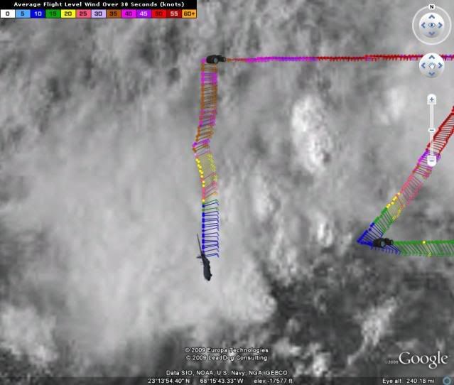
Re: ATL : Invest 92L - Recon Thread
East winds.
URNT15 KNHC 252300
AF302 01AAA INVEST HDOB 26 20090825
225030 2323N 06731W 9771 00299 0114 +198 +182 054023 027 040 013 00
225100 2321N 06731W 9774 00295 0113 +214 +178 069015 016 029 009 00
225130 2320N 06731W 9769 00300 0111 +225 +175 074014 016 025 004 00
225200 2318N 06731W 9769 00300 0111 +225 +174 080015 017 024 002 00
225230 2316N 06731W 9766 00302 0111 +225 +176 079013 013 023 002 00
225300 2315N 06731W 9773 00296 0111 +226 +177 087013 013 023 001 00
225330 2313N 06731W 9770 00299 0111 +227 +179 086013 014 024 001 00
225400 2312N 06731W 9770 00299 0111 +226 +181 084011 012 021 004 00
225430 2310N 06731W 9772 00298 0111 +223 +182 082012 012 022 006 00
225500 2309N 06731W 9770 00299 0112 +215 +183 083012 012 027 006 00
225530 2307N 06731W 9765 00303 0111 +220 +181 077013 015 029 007 00
225600 2305N 06731W 9772 00298 0112 +224 +178 082010 011 022 005 00
225630 2304N 06731W 9773 00297 0111 +225 +178 090012 012 011 003 00
225700 2302N 06731W 9769 00300 0111 +225 +179 092011 011 015 004 00
225730 2301N 06731W 9771 00299 0111 +226 +180 087011 011 020 002 00
225800 2259N 06731W 9771 00298 0110 +229 +181 082012 012 015 004 00
225830 2258N 06731W 9773 00296 0111 +226 +182 078012 012 019 002 00
225900 2256N 06731W 9772 00298 0111 +225 +184 077012 012 015 004 00
225930 2254N 06731W 9770 00299 0111 +225 +185 080012 012 019 002 00
230000 2253N 06731W 9770 00298 0110 +225 +185 076011 012 015 003 00
0 likes
-
BensonTCwatcher

- Category 5

- Posts: 1050
- Joined: Sat Aug 28, 2004 10:11 pm
- Location: Southport NC
Re: ATL: Invest 92L
Yep vort center is right at the crest but recon is not finding closed low. Tomorrow...Hey didn't you say 48 hours about 24 hours ago?
0 likes

Re: ATL: Invest 92L
60 knot winds at flight level (in recon thread) ?!
No west winds yet it seems.
Is this thing cranking up?
Even the mention by Derek O that it has similarities to Andrew makes the hair on the back of my neck stand up.
No west winds yet it seems.
Is this thing cranking up?
Even the mention by Derek O that it has similarities to Andrew makes the hair on the back of my neck stand up.
0 likes
-
Derek Ortt
wind shear is light... what in the world?
does Accuweather lie or do they just not look at the data. There is a UL right next to it (there would be near zero shear if this would get UNDERNEATH the UL, but not remaining to its side
does Accuweather lie or do they just not look at the data. There is a UL right next to it (there would be near zero shear if this would get UNDERNEATH the UL, but not remaining to its side
Last edited by Derek Ortt on Tue Aug 25, 2009 6:10 pm, edited 1 time in total.
0 likes
-
BensonTCwatcher
- Category 5
- Posts: 1050
- Joined: Sat Aug 28, 2004 10:11 pm
- Location: Southport NC
-
Derek Ortt
Re:
I think 'shear'..along with 'sal'....are knee-jerk responses to any developing system....regardless of the data. Or it goes to the other extreme, and the 'sky is falling'. Glad to see 'el nino' is not being listed on their map as a deterring factor. Surprised!
Derek Ortt wrote:wind shear is light...
does Accuweather lie or do they just not look at the data. There is a UL right next to it (there would be near zero shear if this would get UNDERNEATH the UL, but not remaining to its side
0 likes
-
cycloneye
- Admin
- Posts: 148907
- Age: 69
- Joined: Thu Oct 10, 2002 10:54 am
- Location: San Juan, Puerto Rico
Re: ATL : Invest 92L - Recon Thread
East to ESE winds.
URNT15 KNHC 252310
AF302 01AAA INVEST HDOB 27 20090825
230030 2251N 06731W 9770 00298 0110 +227 +185 079011 012 017 004 00
230100 2250N 06731W 9770 00298 0110 +227 +185 083011 012 018 004 00
230130 2248N 06731W 9769 00299 0110 +228 +185 083011 012 022 002 00
230200 2247N 06731W 9769 00299 0110 +226 +186 082012 012 019 003 00
230230 2245N 06731W 9772 00296 0110 +227 +186 090010 011 019 003 00
230300 2243N 06731W 9763 00303 0109 +226 +186 093011 012 019 003 00
230330 2242N 06730W 9761 00308 0110 +227 +186 094011 012 016 003 00
230400 2240N 06730W 9773 00296 0110 +227 +187 088012 013 019 002 00
230430 2238N 06730W 9767 00302 0110 +226 +188 088013 013 019 001 00
230500 2236N 06730W 9772 00296 0109 +225 +189 093012 013 012 002 00
230530 2235N 06730W 9770 00298 0109 +225 +190 095013 013 018 002 00
230600 2233N 06730W 9772 00297 0109 +226 +191 093012 013 019 003 00
230630 2231N 06730W 9770 00298 0109 +225 +192 091012 012 020 001 00
230700 2229N 06730W 9769 00298 0109 +225 +192 087012 012 019 002 00
230730 2227N 06730W 9770 00298 0109 +225 +192 086011 011 019 002 00
230800 2225N 06730W 9772 00295 0109 +225 +192 088010 011 021 000 00
230830 2224N 06730W 9771 00298 0109 +230 +192 091009 009 024 000 00
230900 2222N 06730W 9770 00297 0109 +230 +192 091009 010 022 000 00
230930 2220N 06730W 9770 00297 0109 +226 +193 091009 010 021 000 00
231000 2218N 06730W 9772 00297 0110 +225 +193 101009 009 021 000 00
0 likes
Yeah with regards to Andrew, about halfway between its formation and the US recon couldn't find a closed circulation, the only reason why the NHC kept it as a system was the very powerful MLC that was producing near hurricane winds aloft.
Anyway this system is still a mess of multiple eddies IMO, will be interesting to see whether the ULL moves away from this or not.
Anyway this system is still a mess of multiple eddies IMO, will be interesting to see whether the ULL moves away from this or not.
0 likes
-
Jevo

- S2K Supporter

- Posts: 1729
- Age: 47
- Joined: Tue Aug 03, 2004 8:45 pm
- Location: The Flemish Cap
- Contact:
Re: ATL: Invest 92L
HURAKAN wrote:
Hooray Slack-U-Weather
Image shows a TS Parallel to Cape Canaveral going straight for Cape Cod....
PS HURAKAN.. not kocking you... I know youre just posting the info
0 likes

Who is online
Users browsing this forum: No registered users and 82 guests