ATL: HELENE - Post-Tropical

Moderator: S2k Moderators

Message
Author
User avatar
brunota2003
S2K Supporter
S2K Supporter
Posts: 9476
Age: 34
Joined: Sat Jul 30, 2005 9:56 pm
Location: Stanton, KY...formerly Havelock, NC
Contact:

Re: ATL: SEVEN - Tropical Depression

#641 Postby brunota2003 » Fri Aug 10, 2012 6:29 pm

ROCK wrote:I dont think bones would be laughing if this got into the GOM and crushed NOLA as depicted by the 18Z NOGAPS....just sayin... 8-)

https://www.fnmoc.navy.mil/wxmap_cgi/cg ... t=Tropical

Yeah...and it crosses Hispaniola (?), along with almost the entire length of Cuba before going into the GOM.
0 likes   
Just a small town southern boy helping other humans.

User avatar
brunota2003
S2K Supporter
S2K Supporter
Posts: 9476
Age: 34
Joined: Sat Jul 30, 2005 9:56 pm
Location: Stanton, KY...formerly Havelock, NC
Contact:

Re: ATL: SEVEN - Tropical Depression

#642 Postby brunota2003 » Fri Aug 10, 2012 6:32 pm

Aric Dunn wrote:
ozonepete wrote:
drezee wrote:TD 7 is getting close to Buoy 41040:
Sustained Winds: 31kts
Gust:35kts
Pressure: 1011mb


Hmmm. That buoy is well north of the tight center too.


only about 50 to 100 miles or so. the south side should have weaker winds. however before the axis passes should give us a good estimate. the next hour should have the highest winds if it takes the measurement at the right time.

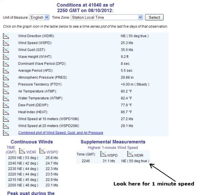
They have a section for "peak highest 1 minute sustained winds", so it doesn't need to take it at the right time, it just needs to "survive" to report it.
0 likes   
Just a small town southern boy helping other humans.

User avatar
cycloneye
Admin
Admin
Posts: 145323
Age: 68
Joined: Thu Oct 10, 2002 10:54 am
Location: San Juan, Puerto Rico

Re: ATL: SEVEN - Advisories

#643 Postby cycloneye » Fri Aug 10, 2012 6:39 pm

WTNT32 KNHC 102337
TCPAT2

BULLETIN
TROPICAL DEPRESSION SEVEN INTERMEDIATE ADVISORY NUMBER 5A
NWS NATIONAL HURRICANE CENTER MIAMI FL AL072012
800 PM AST FRI AUG 10 2012

...TROPICAL DEPRESSION RACING WESTWARD...EXPECTED TO MOVE OVER THE
WINDWARD ISLANDS SATURDAY...


SUMMARY OF 800 PM AST...0000 UTC...INFORMATION
----------------------------------------------
LOCATION...13.8N 52.8W
ABOUT 450 MI...725 KM E OF BARBADOS
ABOUT 550 MI...890 KM E OF MARTINIQUE
MAXIMUM SUSTAINED WINDS...35 MPH...55 KM/H
PRESENT MOVEMENT...W OR 270 DEGREES AT 24 MPH...39 KM/H
MINIMUM CENTRAL PRESSURE...1009 MB...29.80 INCHES


WATCHES AND WARNINGS
--------------------
CHANGES WITH THIS ADVISORY...

NONE.

SUMMARY OF WATCHES AND WARNINGS IN EFFECT...

A TROPICAL STORM WATCH IS IN EFFECT FOR...
* GUADELOUPE AND MARTINIQUE
* DOMINICA
* ST. LUCIA
* BARBADOS
* ST. VINCENT AND THE GRENADINES

A TROPICAL STORM WATCH MEANS THAT TROPICAL STORM CONDITIONS ARE
POSSIBLE WITHIN THE WATCH AREA...IN THIS CASE IN 24 TO 36 HOURS.

FOR STORM INFORMATION SPECIFIC TO YOUR AREA...PLEASE MONITOR
PRODUCTS ISSUED BY YOUR NATIONAL METEOROLOGICAL SERVICE.


DISCUSSION AND 48-HOUR OUTLOOK
------------------------------
AT 800 PM AST...0000 UTC...THE CENTER OF TROPICAL DEPRESSION SEVEN
WAS LOCATED NEAR LATITUDE 13.8 NORTH...LONGITUDE 52.8 WEST. THE
DEPRESSION IS MOVING TOWARD THE WEST NEAR 24 MPH...39 KM/H...AND
THIS GENERAL MOTION IS EXPECTED TO CONTINUE THROUGH SUNDAY. ON THE
FORECAST TRACK...THE CENTER OF THE CYCLONE WILL BE NEAR THE
WINDWARD ISLANDS ON SATURDAY.

MAXIMUM SUSTAINED WINDS REMAIN NEAR 35 MPH...55 KM/H...WITH HIGHER
GUSTS. SOME STRENGTHENING IS POSSIBLE OVER THE NEXT DAY OR SO...AND
THE DEPRESSION COULD BECOME A TROPICAL STORM BEFORE REACHING THE
ISLANDS.

NOAA BUOY 41040...LOCATED ABOUT 50 MILES...80 KM...NORTH-NORTHWEST
OF THE CENTER OF THE DEPRESSION...RECENTLY REPORTED A SUSTAINED
WIND OF 36 MPH...57 KM/H...AND A GUST OF 40 MPH...65 KM/H.

THE ESTIMATED MINIMUM CENTRAL PRESSURE IS 1009 MB...29.80 INCHES.


HAZARDS AFFECTING LAND
----------------------
WIND...TROPICAL STORM CONDITIONS ARE POSSIBLE WITHIN THE WATCH AREA
SATURDAY AND SATURDAY NIGHT.

RAINFALL...TOTAL RAINFALL ACCUMULATIONS OF 1 TO 2 INCHES WITH
ISOLATED MAXIMUM AMOUNTS OF 3 INCHES ARE EXPECTED ACROSS PORTIONS
OF THE LESSER ANTILLES THROUGH SATURDAY.


NEXT ADVISORY
-------------
NEXT COMPLETE ADVISORY...1100 PM AST.

$$
FORECASTER BRENNAN
0 likes   
Visit the Caribbean-Central America Weather Thread where you can find at first post web cams,radars
and observations from Caribbean basin members Click Here

Aric Dunn
Category 5
Category 5
Posts: 21238
Age: 42
Joined: Sun Sep 19, 2004 9:58 pm
Location: Ready for the Chase.
Contact:

Re: ATL: SEVEN - Tropical Depression

#644 Postby Aric Dunn » Fri Aug 10, 2012 6:43 pm

brunota2003 wrote:
Aric Dunn wrote:
ozonepete wrote:
Hmmm. That buoy is well north of the tight center too.


only about 50 to 100 miles or so. the south side should have weaker winds. however before the axis passes should give us a good estimate. the next hour should have the highest winds if it takes the measurement at the right time.

They have a section for "peak highest 1 minute sustained winds", so it doesn't need to take it at the right time, it just needs to "survive" to report it.


Thats right forgot that was on there. :)

the past hour was 31kts... not too far off.
0 likes   
Note: If I make a post that is brief. Please refer back to previous posts for the analysis or reasoning. I do not re-write/qoute what my initial post said each time.
If there is nothing before... then just ask :)

Space & Atmospheric Physicist, Embry-Riddle Aeronautical University,
I believe the sky is falling...

FutureEM
Tropical Storm
Tropical Storm
Posts: 139
Joined: Sat May 19, 2012 8:16 am

Re: ATL: SEVEN - Tropical Depression

#645 Postby FutureEM » Fri Aug 10, 2012 6:50 pm

ROCK wrote:I dont think bones would be laughing if this got into the GOM and crushed NOLA as depicted by the 18Z NOGAPS....just sayin... 8-)

https://www.fnmoc.navy.mil/wxmap_cgi/cg ... t=Tropical


That seems pretty wacky intensity wise, it initializes it strong and then shows it maintain good strength over not just Hispaniola but Cuba as well.
0 likes   

ozonepete
Professional-Met
Professional-Met
Posts: 4743
Joined: Mon Sep 07, 2009 3:23 pm
Location: From Ozone Park, NYC / Now in Brooklyn, NY

Re: ATL: SEVEN - Tropical Depression

#646 Postby ozonepete » Fri Aug 10, 2012 6:54 pm

FutureEM wrote:
ROCK wrote:I dont think bones would be laughing if this got into the GOM and crushed NOLA as depicted by the 18Z NOGAPS....just sayin... 8-)

https://www.fnmoc.navy.mil/wxmap_cgi/cg ... t=Tropical


That seems pretty wacky intensity wise, it initializes it strong and then shows it maintain good strength over not just Hispaniola but Cuba as well.


Yeah don't give that too much credence. NOGAPS isn't a great performer in the Atlantic, though I'm not bashing it, lol. That track speaks for itself.

Personal Forecast Disclaimer:
The posts in this forum are NOT official forecast and should not be used as such. They are just the opinion of the poster and may or may not be backed by sound meteorological data. They are NOT endorsed by any professional institution or storm2k.org. For official information, please refer to the NHC and NWS products.
0 likes   

FutureEM
Tropical Storm
Tropical Storm
Posts: 139
Joined: Sat May 19, 2012 8:16 am

#647 Postby FutureEM » Fri Aug 10, 2012 6:59 pm

So it has sustained TS winds, do you all think the NHC is waiting to see if the LLC develops more?
0 likes   

User avatar
brunota2003
S2K Supporter
S2K Supporter
Posts: 9476
Age: 34
Joined: Sat Jul 30, 2005 9:56 pm
Location: Stanton, KY...formerly Havelock, NC
Contact:

Re: ATL: SEVEN - Tropical Depression

#648 Postby brunota2003 » Fri Aug 10, 2012 7:00 pm

Aric Dunn wrote:
Thats right forgot that was on there. :)

the past hour was 31kts... not too far off.

Only some buoys have it...and this one (41040) along with 41041 (the one TD7 passed over last night) have it...I wish all NDBC moored buoys had it!
0 likes   
Just a small town southern boy helping other humans.

User avatar
AnnularCane
S2K Supporter
S2K Supporter
Posts: 2862
Joined: Thu Jun 08, 2006 9:18 am
Location: Wytheville, VA

Re: ATL: SEVEN - Tropical Depression

#649 Postby AnnularCane » Fri Aug 10, 2012 7:00 pm

To be honest, I'm not so eager for this to be named anymore, not if it's just going to fall apart soon. Maybe if it had a few more days at least... :(
0 likes   

User avatar
brunota2003
S2K Supporter
S2K Supporter
Posts: 9476
Age: 34
Joined: Sat Jul 30, 2005 9:56 pm
Location: Stanton, KY...formerly Havelock, NC
Contact:

Re:

#650 Postby brunota2003 » Fri Aug 10, 2012 7:02 pm

FutureEM wrote:So it has sustained TS winds, do you all think the NHC is waiting to see if the LLC develops more?

The buoy has not reported sustained TS winds yet, and no guarantee it will.

NOAA BUOY 41040...LOCATED ABOUT 50 MILES...80 KM...NORTH-NORTHWEST
OF THE CENTER OF THE DEPRESSION...RECENTLY REPORTED A SUSTAINED
WIND OF 36 MPH...57 KM/H...AND A GUST OF 40 MPH...65 KM/H.
0 likes   
Just a small town southern boy helping other humans.

ozonepete
Professional-Met
Professional-Met
Posts: 4743
Joined: Mon Sep 07, 2009 3:23 pm
Location: From Ozone Park, NYC / Now in Brooklyn, NY

Re: ATL: SEVEN - Tropical Depression

#651 Postby ozonepete » Fri Aug 10, 2012 7:02 pm

Aric Dunn wrote:
brunota2003 wrote:They have a section for "peak highest 1 minute sustained winds", so it doesn't need to take it at the right time, it just needs to "survive" to report it.


Thats right forgot that was on there. :)

the past hour was 31kts... not too far off.


Here's where to look...


Image
0 likes   

User avatar
brunota2003
S2K Supporter
S2K Supporter
Posts: 9476
Age: 34
Joined: Sat Jul 30, 2005 9:56 pm
Location: Stanton, KY...formerly Havelock, NC
Contact:

#652 Postby brunota2003 » Fri Aug 10, 2012 7:23 pm

Pressure back on the rise at the buoy, no TS winds

Highest 1-minute Wind Speed
Time (EDT) 5-day plot - 1-Minute Wind Speed WSPD 5-day plot - 1-Minute Wind Direction WDIR
7:09 pm 29.1 kts ENE ( 60 deg true )
0 likes   
Just a small town southern boy helping other humans.

ozonepete
Professional-Met
Professional-Met
Posts: 4743
Joined: Mon Sep 07, 2009 3:23 pm
Location: From Ozone Park, NYC / Now in Brooklyn, NY

Re:

#653 Postby ozonepete » Fri Aug 10, 2012 7:26 pm

brunota2003 wrote:Pressure back on the rise at the buoy, no TS winds

Highest 1-minute Wind Speed
Time (EDT) 5-day plot - 1-Minute Wind Speed WSPD 5-day plot - 1-Minute Wind Direction WDIR
7:09 pm 29.1 kts ENE ( 60 deg true )


Yeah, no really big surpise. The center is still too far away to make a clear determination. They may have to call it tomorrow from land stations in the islands, meaning it does have TS winds or doesn't (not saying what they will be). Sometimes it just comes to that, unfortunately.
0 likes   

User avatar
cycloneye
Admin
Admin
Posts: 145323
Age: 68
Joined: Thu Oct 10, 2002 10:54 am
Location: San Juan, Puerto Rico

Re: ATL: SEVEN - Tropical Depression

#654 Postby cycloneye » Fri Aug 10, 2012 7:28 pm

00z Best Track

AL, 07, 2012081100, , BEST, 0, 138N, 531W, 30, 1009, TD

ftp://ftp.nhc.noaa.gov/atcf/tcweb/inves ... 012.invest
0 likes   
Visit the Caribbean-Central America Weather Thread where you can find at first post web cams,radars
and observations from Caribbean basin members Click Here

Aric Dunn
Category 5
Category 5
Posts: 21238
Age: 42
Joined: Sun Sep 19, 2004 9:58 pm
Location: Ready for the Chase.
Contact:

Re:

#655 Postby Aric Dunn » Fri Aug 10, 2012 7:31 pm

brunota2003 wrote:Pressure back on the rise at the buoy, no TS winds

Highest 1-minute Wind Speed
Time (EDT) 5-day plot - 1-Minute Wind Speed WSPD 5-day plot - 1-Minute Wind Direction WDIR
7:09 pm 29.1 kts ENE ( 60 deg true )


yeah it passed the buoy. have to wait for recon tomorrow.
0 likes   
Note: If I make a post that is brief. Please refer back to previous posts for the analysis or reasoning. I do not re-write/qoute what my initial post said each time.
If there is nothing before... then just ask :)

Space & Atmospheric Physicist, Embry-Riddle Aeronautical University,
I believe the sky is falling...

christchurchguy
Tropical Low
Tropical Low
Posts: 43
Joined: Sat Sep 19, 2009 10:31 am

Re: ATL: SEVEN - Tropical Depression

#656 Postby christchurchguy » Fri Aug 10, 2012 7:45 pm

how difficult is it to tell the intensity from the structure on land radar from Barbados, Trinidad or the french antilles. When was the last microwave pass. I remember Emily I think it was where It was much better organized on recon than appeared on sat

Its looking more circular on recent loops but most convection south whats the chance for a center relocation southward?
0 likes   

ozonepete
Professional-Met
Professional-Met
Posts: 4743
Joined: Mon Sep 07, 2009 3:23 pm
Location: From Ozone Park, NYC / Now in Brooklyn, NY

Re: Re:

#657 Postby ozonepete » Fri Aug 10, 2012 7:45 pm

Aric Dunn wrote:
brunota2003 wrote:Pressure back on the rise at the buoy, no TS winds

Highest 1-minute Wind Speed
Time (EDT) 5-day plot - 1-Minute Wind Speed WSPD 5-day plot - 1-Minute Wind Direction WDIR
7:09 pm 29.1 kts ENE ( 60 deg true )


yeah it passed the buoy. have to wait for recon tomorrow.


What time is RECON? Barbados may tell us a lot before RECON does.
0 likes   

christchurchguy
Tropical Low
Tropical Low
Posts: 43
Joined: Sat Sep 19, 2009 10:31 am

#658 Postby christchurchguy » Fri Aug 10, 2012 7:48 pm

It should appear on radar 8-10 hours from now or so
0 likes   

User avatar
cycloneye
Admin
Admin
Posts: 145323
Age: 68
Joined: Thu Oct 10, 2002 10:54 am
Location: San Juan, Puerto Rico

Re: ATL: SEVEN - Tropical Depression

#659 Postby cycloneye » Fri Aug 10, 2012 7:57 pm

ozonepete,first mission departs at 6:15 PM EDT.

Code: Select all

WEATHER RECONNAISSANCE FLIGHTS
CARCAH, NATIONAL HURRICANE CENTER, MIAMI, FL.
1045 AM EDT FRI 10 AUGUST 2012
SUBJECT: TROPICAL CYCLONE PLAN OF THE DAY (TCPOD)
         VALID 11/1100Z TO 12/1100Z AUGUST 2012
         TCPOD NUMBER.....12-084

I. ATLANTIC REQUIREMENTS
    1. TROPICAL DEPRESSION SEVEN
       FLIGHT ONE - TEAL 71 -      FLIGHT TWO - TEAL 72 -
       A. 12/0000, 0600Z           A. 12/1200Z
       B. AFXXX 0207A CYCLONE      B. AFXXX 0307A CYCLONE
       C. 11/2215Z                 C. 12/1030Z
       D. 14.1N 59.1W              D. 14.6N 62.5W
       E. 11/2330Z TO 12/0600Z     E. 12/1130Z TO 12/1530Z
       F. SFC TO 10,000 FT         F. SFC TO 10,000 FT

    2. OUTLOOK FOR SUCCEEDING DAY: CONTINUE 12-HRLY FIXES
       IF SYSTEM IS STILL A THREAT.
0 likes   
Visit the Caribbean-Central America Weather Thread where you can find at first post web cams,radars
and observations from Caribbean basin members Click Here

User avatar
Hurricane Alexis
Category 2
Category 2
Posts: 683
Age: 29
Joined: Thu Jun 14, 2012 7:59 pm
Location: Miami,Florida

Re: ATL: SEVEN - Models

#660 Postby Hurricane Alexis » Fri Aug 10, 2012 8:13 pm

wxman57 wrote:Consensus models shifted north because both the NOGAPS (worthless model) and UKMET take 7 north of the Caribbean toward the eastern Bahamas. That's unlikely, given the projected ridge (by GFS/Euro) building to its north. That ridge is forecast to extend form the Bahamas to Texas by next Wednesday. Throw those two models out and you have a track very much like Ernesto, except that this system may not survive the shear and dry air.


Why is the NOGAPS worthless lol?
0 likes   
Personal Forecast Disclaimer:
The posts in this forum are NOT official forecast and should not be used as such. They are just the opinion of the poster and may or may not be backed by sound meteorological data. They are NOT endorsed by any professional institution or storm2k.org. For official information, please refer to the NHC and NWS products.


Return to “2012”

Who is online

Users browsing this forum: No registered users and 4 guests