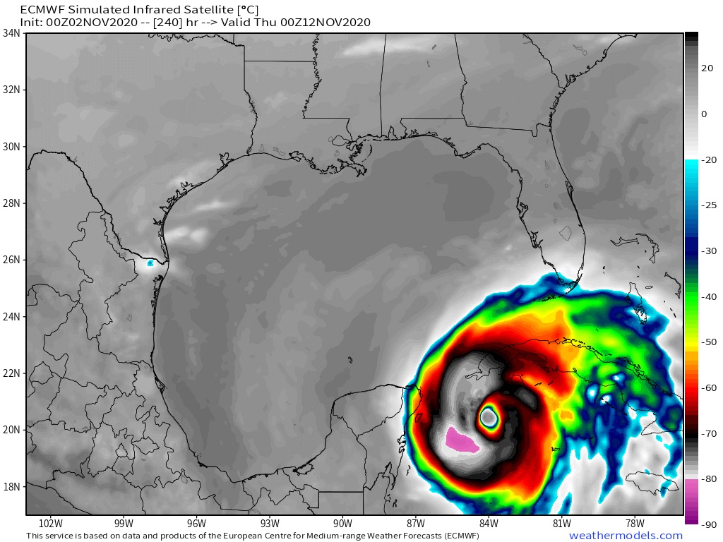
930mb from the Euro! Now that's something you don't see everyday...
ATL: ETA - Models
Moderator: S2k Moderators
-
ElectricStorm

- Category 5

- Posts: 5124
- Age: 24
- Joined: Tue Aug 13, 2019 11:23 pm
- Location: Norman, OK
Re: ATL: ETA - Models
930mb from the Euro! Now that's something you don't see everyday...
0 likes
B.S Meteorology, University of Oklahoma '25
Please refer to the NHC, NWS, or SPC for official information.
Please refer to the NHC, NWS, or SPC for official information.
-
AxaltaRacing24
- Category 5
- Posts: 1774
- Age: 25
- Joined: Wed Jul 27, 2016 11:14 am
- Location: Jupiter, FL
Re: ATL: ETA - Models
Weather Dude wrote:
930mb from the Euro! Now that's something you don't see everyday...
one of the lowest reading's i have ever seen it show in this basin.
0 likes
-
SouthFLTropics

- Category 5
- Posts: 4258
- Age: 50
- Joined: Thu Aug 14, 2003 8:04 am
- Location: Port St. Lucie, Florida
Re: ATL: ETA - Models
Weather Dude wrote:
930mb from the Euro! Now that's something you don't see everyday...
That was the same thought I had... how this re-emerges into the Gulf of Honduras is going to be very interesting.
Sent from my iPhone using Tapatalk
0 likes
Fourth Generation Florida Native
Personal Storm History: David 79, Andrew 92, Erin 95, Floyd 99, Irene 99, Frances 04, Jeanne 04, Wilma 05, Matthew 16, Irma 17, Ian 22, Nicole 22, Milton 24
Personal Storm History: David 79, Andrew 92, Erin 95, Floyd 99, Irene 99, Frances 04, Jeanne 04, Wilma 05, Matthew 16, Irma 17, Ian 22, Nicole 22, Milton 24
-
Kingarabian

- S2K Supporter

- Posts: 16321
- Joined: Sat Aug 08, 2009 3:06 am
- Location: Honolulu, Hawaii

-
ColdMiser123

- Professional-Met

- Posts: 905
- Age: 29
- Joined: Mon Sep 26, 2016 3:26 pm
- Location: Northeast US
Re: ATL: ETA - Models
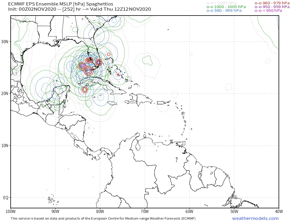
Lots of strong solutions on the EPS and many threatening Florida after dealing significant impacts to Central America.
3 likes
B.S., M.S., Meteorology & Atmospheric Science


Re: ATL: ETA - Models
Kingarabian wrote:Hi-Res 00z Euro has a borderline Cat.5 922mb:
https://i.imgur.com/214tJP4.png
That would make Eta the latest Category 5 hurricane on record surpassing the 1932 Cuba hurricane which maintained CAT 5 status until November 9 while this forecast calls for it as at CAT 5 on November 12
0 likes
Re: ATL: ETA - Models
0Z UKMET: much stronger than prior run but not much change in track with it going to the EPAC before coming back NE toward Guatamela. This remains a left outlier from an often left biased model.
WTNT82 EGRR 020358
MET OFFICE TROPICAL CYCLONE GUIDANCE FOR NORTH-EAST PACIFIC AND ATLANTIC
GLOBAL MODEL DATA TIME 0000UTC 02.11.2020
TROPICAL STORM ETA ANALYSED POSITION : 14.9N 79.2W
ATCF IDENTIFIER : AL292020
LEAD CENTRAL MAXIMUM WIND
VERIFYING TIME TIME POSITION PRESSURE (MB) SPEED (KNOTS)
-------------- ---- -------- ------------- -------------
0000UTC 02.11.2020 0 14.9N 79.2W 1001 36
1200UTC 02.11.2020 12 14.5N 81.4W 998 40
0000UTC 03.11.2020 24 13.7N 82.5W 991 42
1200UTC 03.11.2020 36 13.4N 83.2W 977 56
0000UTC 04.11.2020 48 13.2N 84.1W 988 39
1200UTC 04.11.2020 60 12.8N 85.8W 998 33
0000UTC 05.11.2020 72 12.8N 87.4W 999 35
1200UTC 05.11.2020 84 12.8N 89.0W 998 38
0000UTC 06.11.2020 96 12.5N 90.1W 998 37
1200UTC 06.11.2020 108 12.8N 89.3W 1000 33
0000UTC 07.11.2020 120 CEASED TRACKING
3 likes
Personal Forecast Disclaimer:
The posts in this forum are NOT official forecasts and should not be used as such. They are just the opinion of the poster and may or may not be backed by sound meteorological data. They are NOT endorsed by any professional institution or storm2k.org. For official information, please refer to the NHC and NWS products.
The posts in this forum are NOT official forecasts and should not be used as such. They are just the opinion of the poster and may or may not be backed by sound meteorological data. They are NOT endorsed by any professional institution or storm2k.org. For official information, please refer to the NHC and NWS products.
-
SFLcane

- S2K Supporter
- Posts: 10281
- Age: 48
- Joined: Sat Jun 05, 2010 1:44 pm
- Location: Lake Worth Florida
Re: ATL: ETA - Models
ColdMiser123 wrote:Lots of strong solutions on the EPS and many threatening Florida after dealing significant impacts to Central America.
I think it’s becoming increasingly likely will be dealing with some kind of system in the nw Caribbean Sea late this week. 00z euro after dropping the ball many times this year is a huge eye opener for me atleast wow.
0 likes
-
Keldeo1997
- Category 2

- Posts: 688
- Joined: Fri Oct 11, 2019 11:35 pm

-
DESTRUCTION5

- Category 5
- Posts: 4430
- Age: 44
- Joined: Wed Sep 03, 2003 11:25 am
- Location: Stuart, FL
Re: ATL: ETA - Models
06 GFS just does all kinds of evil things including Wilma II into SF.
2 likes
GATOR NATION IS E V E R Y W H E R E !

Re: ATL: ETA - Models
Both the GFS and Euro have a powerful, wandering hurricane in the WCar after exiting Central America. I’m shocked at how aggressive the Euro is this run.
2 likes
Irene '11 Sandy '12 Hermine '16 5/15/2018 Derecho Fay '20 Isaias '20 Elsa '21 Henri '21 Ida '21
I am only a meteorology enthusiast who knows a decent amount about tropical cyclones. Look to the professional mets, the NHC, or your local weather office for the best information.
I am only a meteorology enthusiast who knows a decent amount about tropical cyclones. Look to the professional mets, the NHC, or your local weather office for the best information.
-
supercane4867
- Category 5
- Posts: 4966
- Joined: Wed Nov 14, 2012 10:43 am
Re: ATL: ETA - Models
People are going to panic big time when they wake up and see the euro run this morning lol
0 likes
-
DESTRUCTION5
- Category 5
- Posts: 4430
- Age: 44
- Joined: Wed Sep 03, 2003 11:25 am
- Location: Stuart, FL
Re: ATL: ETA - Models
That's what I would call a cluster F$#@.
2 likes
GATOR NATION IS E V E R Y W H E R E !

Re: ATL: ETA - Models
If models are correct Eta will be one heck of an ACE producer, unusual for this time of the year.
0 likes

Re: ATL: ETA - Models
Wildly diverging time.scales between the fast CMC/HWRF and slow Euro exiting the Gulf of Honduras. Probably the slower solution is more likely given divergent steering this time of year and ETA taking time to reorganize. But who knows?
2 likes
Re: ATL: ETA - Models
930 mbar on the Euro for an Atlantic storm 
You really don’t see that a whole lot anymore...
You really don’t see that a whole lot anymore...
2 likes
Irene '11 Sandy '12 Hermine '16 5/15/2018 Derecho Fay '20 Isaias '20 Elsa '21 Henri '21 Ida '21
I am only a meteorology enthusiast who knows a decent amount about tropical cyclones. Look to the professional mets, the NHC, or your local weather office for the best information.
I am only a meteorology enthusiast who knows a decent amount about tropical cyclones. Look to the professional mets, the NHC, or your local weather office for the best information.
Re: ATL: ETA - Models
ronjon wrote:Wildly diverging time.scales between the fast CMC/HWRF and slow Euro exiting the Gulf of Honduras. Probably the slower solution is more likely given divergent steering this time of year and ETA taking time to reorganize. But who knows?
As usual I am going with a split difference between the GFS and Euro of it exiting the GOH starting late Friday. The GFS has it exiting it Friday during the day while the Euro during the day Saturday.
0 likes

Re: ATL: ETA - Models
You guys would all laughing if this set up was in the month of June and this is mid of November. Sure something might be brewing but a cat 5. I do not think so. A few storms form in that area this year and nothing like that. Another cold front just past threw in south florida this morning. Anyway its 10 days plus away .
you guys would be laughing
you guys would be laughing
0 likes
Who is online
Users browsing this forum: No registered users and 25 guests