ATL: IDALIA - Models
Moderator: S2k Moderators

Re: ATL: IDALIA - Models
The lesson i learned is until this is north of cuba we don’t know where this is going. these storms either go north or east with wobbling so in my mind with its location i hv no idea but be prepared anyway and hv a evac plan if needed and plan for the worst and hope for the best.
5 likes
Robbielyn McCrary
I know just about enough to sound like I know what I'm talking about sometimes. But for your safety please follow the nhc for truly professional forecasting.
I know just about enough to sound like I know what I'm talking about sometimes. But for your safety please follow the nhc for truly professional forecasting.
-
toad strangler

- S2K Supporter

- Posts: 4546
- Joined: Sun Jul 28, 2013 3:09 pm
- Location: Earth
- Contact:
Re: ATL: IDALIA - Models
robbielyn wrote:The lesson i learned is until this is north of cuba we don’t know where this is going. these storms either go north or east with wobbling so in my mind with its location i hv no idea but be prepared anyway and hv a evac plan if needed and plan for the worst and hope for the best.
Agreed, it's not like this system is heading for the northern Gulf Coast which runs for all intents and purposes from W to E. That S to NNW coast line of the Eastern Gulf can make any E move (even the slightest) have huge ramifications for landfall when coming in as close as modeled. As we have seen in recent history.
2 likes
My Weather Station
https://www.wunderground.com/dashboard/pws/KFLPORTS603
https://www.wunderground.com/dashboard/pws/KFLPORTS603
-
TallyTracker
- Category 2

- Posts: 787
- Joined: Thu Oct 11, 2018 2:46 pm
Re: ATL: IDALIA - Models
I went through all of the Global and Hurricane Model runs from 00z and some 06z. Most of them are still coming in between St. Marks and Keaton Beach. The NHC track still seems to far east compared to the consensus. Am I seeing that right?
0 likes
Fran '96, Georges '98, Gordon '00, Gabrielle '01, Charley '04, Frances '04, Jeanne '04, Barry '07, Fay '08, Debby '12, Matthew '16, Emily '17, Irma '17, Michael ‘18, Elsa ‘21, Fred ‘21, Mindy ‘21, Nicole ‘22, Idalia ‘23, Debby ‘24, Helene ‘24
-
chris_fit

- Category 5

- Posts: 3261
- Age: 43
- Joined: Wed Sep 10, 2003 11:58 pm
- Location: Tampa Bay Area, FL
Re: ATL: IDALIA - Models
Most of the 06Z Hurricane models (HAFS-A, HAFS-B, HWRF) are trending slower and more E (though not drastic, although the HWRF is almost a full degree south at 36 hours.)
HMON went more W.
HMON went more W.
1 likes

Re: ATL: IDALIA - Models
06z hurricane models all seem to indicate a high-end cat 3 or low-end cat 4 before landfall.


1 likes
Re: ATL: IDALIA - Models
kevin wrote:06z hurricane models all seem to indicate a high-end cat 3 or low-end cat 4 before landfall.
https://i.imgur.com/6HnPGfO.png
https://i.imgur.com/Q88RnzY.png
https://i.imgur.com/DJ86wOH.png
https://i.imgur.com/zVlPG7D.png
Hmon and hwrf I highly doubt. It would need to move due North for those to verify
0 likes
-
Hypercane_Kyle

- Category 5
- Posts: 3465
- Joined: Sat Mar 07, 2015 7:58 pm
- Location: Cape Canaveral, FL
Re: ATL: IDALIA - Models
GFS seems to want to jolt Idalia NW at some point today. That does not seem very realistic to me.
0 likes
My posts are my own personal opinion, defer to the National Hurricane Center (NHC) and other NOAA products for decision making during hurricane season.
-
chris_fit
- Category 5
- Posts: 3261
- Age: 43
- Joined: Wed Sep 10, 2003 11:58 pm
- Location: Tampa Bay Area, FL
Re: ATL: IDALIA - Models
06Z EURO is running!
Noticeable W shift, slower, and stronger - and we're on hour 12. Going to be an interesting run!

Noticeable W shift, slower, and stronger - and we're on hour 12. Going to be an interesting run!
0 likes


Re: ATL: IDALIA - Models
chris_fit wrote:06Z EURO is running!
Noticeable W shift, slower, and stronger - and we're on hour 12. Going to be an interesting run!
https://i.imgur.com/B2zVxO3.png
Euro shifted east of 00z. and is east of the gfs at 24 hours out
0 likes
-
chris_fit
- Category 5
- Posts: 3261
- Age: 43
- Joined: Wed Sep 10, 2003 11:58 pm
- Location: Tampa Bay Area, FL
Re: ATL: IDALIA - Models
Cat5James wrote:chris_fit wrote:06Z EURO is running!
Noticeable W shift, slower, and stronger - and we're on hour 12. Going to be an interesting run!
https://i.imgur.com/B2zVxO3.png
Euro shifted east of 00z. and is east of the gfs at 24 hours out
At 12 hours it was W... now appears to be more or less like the previous run @ 30hrs.
0 likes
-
chris_fit
- Category 5
- Posts: 3261
- Age: 43
- Joined: Wed Sep 10, 2003 11:58 pm
- Location: Tampa Bay Area, FL
Re: ATL: IDALIA - Models
Same exact spot as the 00Z Run - just quite a bit stronger. Such a compact storm!

1 likes

Re: ATL: IDALIA - Models
very interesting how many models have that NW movement for at least a few hours today, may be enough to save Tampa from much worse conditions if it verifies
1 likes
Just like Jon Snow..."I know nothing" except what I know, and most of what I know is gathered by the fine people of the NHC

Re: ATL: IDALIA - Models
Through 48 hrs 06z GFS is almost a spit image of its earlier track, a little slower and stronger.
0 likes

-
Blown Away

- S2K Supporter
- Posts: 10253
- Joined: Wed May 26, 2004 6:17 am
Re: ATL: IDALIA - Models
06z Euro… Definitely stronger and landfall just N of Cedar Key. Nearly same spot as 00z.
0 likes
Hurricane Eye Experience: David 79, Irene 99, Frances 04, Jeanne 04, Wilma 05… Hurricane Brush Experience: Andrew 92, Erin 95, Floyd 99, Matthew 16, Irma 17, Ian 22, Nicole 22…
-
chris_fit
- Category 5
- Posts: 3261
- Age: 43
- Joined: Wed Sep 10, 2003 11:58 pm
- Location: Tampa Bay Area, FL
Re: ATL: IDALIA - Models
06z UKMET - decent shift E, and to the right of the Official Track.

2 likes
Re: ATL: IDALIA - Models
Blown Away wrote:[url]https://i.postimg.cc/GpHGy83g/9-km-ECMWF-Global-00z-12z-3-Hourly-Southwest-Atlantic-MSLP-6.gif [/url]
06z Euro… Definitely stronger and landfall just N of Cedar Key. Nearly same spot as 00z.
Strongest Euro run so far if I recall correctly.
0 likes
-
tolakram
- Admin

- Posts: 20179
- Age: 62
- Joined: Sun Aug 27, 2006 8:23 pm
- Location: Florence, KY (name is Mark)
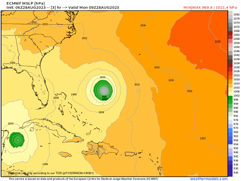
Re: ATL: IDALIA - Models
Euro 6Z landfall

1 likes
M a r k
- - - - -
Join us in chat: Storm2K Chatroom Invite. Android and IOS apps also available.
The posts in this forum are NOT official forecasts and should not be used as such. Posts are NOT endorsed by any professional institution or STORM2K.org. For official information and forecasts, please refer to NHC and NWS products.
Re: ATL: IDALIA - Models
Today is a day to see if there is any late model shifts, with 48 hrs before landfall current track is not written on stone, but good to see the Euro stay consistent on a landfall spot within 10-20 miles for at least 4 runs in row.

1 likes
Who is online
Users browsing this forum: No registered users and 106 guests