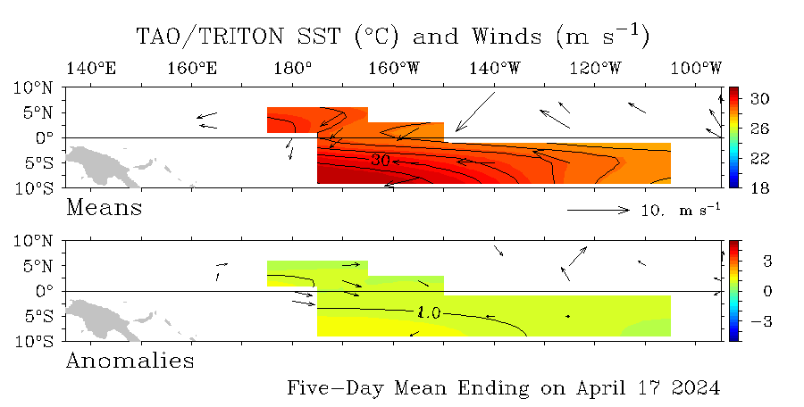
SST'S and Anomalies in Atlantic and Pacific

This is the general tropical discussion area. Anyone can take their shot at predicting a storms path.

Moderator: S2k Moderators

Forum rules

The posts in this forum are NOT official forecasts and should not be used as such. They are just the opinion of the poster and may or may not be backed by sound meteorological data. They are NOT endorsed by any professional institution or STORM2K. For official information, please refer to products from the National Hurricane Center and National Weather Service.

Help Support Storm2K
Message
Author
User avatar
cycloneye
Admin
Admin
Posts: 146211
Age: 69
Joined: Thu Oct 10, 2002 10:54 am
Location: San Juan, Puerto Rico

#641 Postby cycloneye » Wed Mar 29, 2006 1:21 pm

Image

Maybe a very slight warming at el nino 4 west of 160w however no change at el nino 1-2 and el nino 3 areas with the cool anomalies persisting.
0 likes   
Visit the Caribbean-Central America Weather Thread where you can find at first post web cams,radars
and observations from Caribbean basin members Click Here

Matt-hurricanewatcher

#642 Postby Matt-hurricanewatcher » Wed Mar 29, 2006 2:05 pm

La nina's are always weak theres never been a La nina that can match even a weak to Mod El nino the other way around. :roll:
0 likes   

User avatar
James
Category 5
Category 5
Posts: 1531
Joined: Tue Aug 24, 2004 10:29 am
Location: Gloucestershire, England
Contact:

#643 Postby James » Wed Mar 29, 2006 2:17 pm

This one came pretty close though:

Image
0 likes   

User avatar
SouthFloridawx
S2K Supporter
S2K Supporter
Posts: 8346
Age: 46
Joined: Tue Jul 26, 2005 1:16 am
Location: Sarasota, FL
Contact:

#644 Postby SouthFloridawx » Wed Mar 29, 2006 2:25 pm

that's a pretty big la nina
0 likes   

Matt-hurricanewatcher

#645 Postby Matt-hurricanewatcher » Wed Mar 29, 2006 2:29 pm

But its not upgainst the south American coast its more centered at 100 west outwards. While the El nino is upgainst the coast.
0 likes   

User avatar
cycloneye
Admin
Admin
Posts: 146211
Age: 69
Joined: Thu Oct 10, 2002 10:54 am
Location: San Juan, Puerto Rico

#646 Postby cycloneye » Wed Mar 29, 2006 3:50 pm

Image

Daily updated graphic of the Atlantic,Caribbean and Gulf of Mexico.
0 likes   

User avatar
SouthFloridawx
S2K Supporter
S2K Supporter
Posts: 8346
Age: 46
Joined: Tue Jul 26, 2005 1:16 am
Location: Sarasota, FL
Contact:

#647 Postby SouthFloridawx » Wed Mar 29, 2006 4:12 pm

Here is cool website I found on el nino and la nina.

http://www.cdc.noaa.gov/ENSO/enso.current.html
0 likes   

CHRISTY

#648 Postby CHRISTY » Wed Mar 29, 2006 5:16 pm

Image
0 likes   

User avatar
windycity
S2K Supporter
S2K Supporter
Posts: 461
Joined: Wed Aug 24, 2005 6:45 pm
Location: P.B.county,Fl.
Contact:

#649 Postby windycity » Wed Mar 29, 2006 8:39 pm

wow,SSTs are toasty.The cold spell didnt do much to bring temps down. :oops:
0 likes   

User avatar
HouTXmetro
Category 5
Category 5
Posts: 3949
Joined: Sun Jun 13, 2004 6:00 pm
Location: District of Columbia, USA

#650 Postby HouTXmetro » Wed Mar 29, 2006 10:37 pm

Wow, looks like most of the GOM and atlantic could support a tropical system if the conditions were right.
0 likes   
[Disclaimer: My Amateur Opinion, please defer to your local authorities or the NHC for Guidance.]

User avatar
cycloneye
Admin
Admin
Posts: 146211
Age: 69
Joined: Thu Oct 10, 2002 10:54 am
Location: San Juan, Puerto Rico

#651 Postby cycloneye » Thu Mar 30, 2006 1:35 pm

Image

The chart above shows at what month the sst's start to rise,reach their peak and then go down.
0 likes   

User avatar
SouthFloridawx
S2K Supporter
S2K Supporter
Posts: 8346
Age: 46
Joined: Tue Jul 26, 2005 1:16 am
Location: Sarasota, FL
Contact:

#652 Postby SouthFloridawx » Thu Mar 30, 2006 2:49 pm

What location is the based on?
0 likes   

User avatar
cycloneye
Admin
Admin
Posts: 146211
Age: 69
Joined: Thu Oct 10, 2002 10:54 am
Location: San Juan, Puerto Rico

#653 Postby cycloneye » Thu Mar 30, 2006 2:54 pm

SouthFloridawx wrote:What location is the based on?


That is of bouy 42040 south of Mobile Bay.
0 likes   
Visit the Caribbean-Central America Weather Thread where you can find at first post web cams,radars
and observations from Caribbean basin members Click Here

User avatar
x-y-no
Category 5
Category 5
Posts: 8359
Age: 65
Joined: Wed Aug 11, 2004 12:14 pm
Location: Fort Lauderdale, FL

#654 Postby x-y-no » Thu Mar 30, 2006 2:55 pm

SouthFloridawx wrote:What location is the based on?


Buoy 42040 is near Dauphin Island, AL

http://www.ndbc.noaa.gov/station_page.php?station=42040
0 likes   

User avatar
SouthFloridawx
S2K Supporter
S2K Supporter
Posts: 8346
Age: 46
Joined: Tue Jul 26, 2005 1:16 am
Location: Sarasota, FL
Contact:

#655 Postby SouthFloridawx » Thu Mar 30, 2006 3:03 pm

Thanks x-y-no, I now see the Buoy number at the top of the chart.

In the middle of the red I suspect that is normal and anything above and below the red is above and below normal. Am I correct to think this?

Therefore the water temperature at Buoy 42040 is normal average temperature right now as the bouy is reporting 20.4 degrees on the top line from the link you provided.
0 likes   

User avatar
cycloneye
Admin
Admin
Posts: 146211
Age: 69
Joined: Thu Oct 10, 2002 10:54 am
Location: San Juan, Puerto Rico

#656 Postby cycloneye » Thu Mar 30, 2006 3:08 pm

Image

Update of the currents.A somewhat less warm loop current than last week.
0 likes   

f5
Category 5
Category 5
Posts: 1550
Joined: Thu Aug 25, 2005 3:29 pm
Location: Waco,tx

#657 Postby f5 » Thu Mar 30, 2006 4:19 pm

James wrote:This one came pretty close though:

Image


that stong La Nina in FEB of 99 resulted in 1140 inches of snow on Mt Baker in Washington state a world record but i think the real world record for snow lies in the mountains around Glacier Bay Alaska
0 likes   

User avatar
cycloneye
Admin
Admin
Posts: 146211
Age: 69
Joined: Thu Oct 10, 2002 10:54 am
Location: San Juan, Puerto Rico

#658 Postby cycloneye » Thu Mar 30, 2006 4:53 pm

Image

The cool area in the Eastern Atlantic is almost gone.However cooler anomalies haved spread in the Western Atlantic Area east of the U.S coast.
0 likes   
Visit the Caribbean-Central America Weather Thread where you can find at first post web cams,radars
and observations from Caribbean basin members Click Here

HurricaneHunter914
Category 5
Category 5
Posts: 4439
Age: 31
Joined: Fri Mar 10, 2006 7:36 pm
Location: College Station, TX

#659 Postby HurricaneHunter914 » Thu Mar 30, 2006 4:58 pm

Probably a cold front.
0 likes   

Weatherfreak000

#660 Postby Weatherfreak000 » Thu Mar 30, 2006 6:13 pm

Is that some weaking of the El Nina i'm seeing?
0 likes   


Return to “Talkin' Tropics”

Who is online

Users browsing this forum: Ethaninfinity, Google [Bot], Google Adsense [Bot], South Texas Storms and 42 guests