CAT 5 Hurricane Dean - Archived threads
Moderator: S2k Moderators


-
BensonTCwatcher

- Category 5

- Posts: 1050
- Joined: Sat Aug 28, 2004 10:11 pm
- Location: Southport NC
Hmm couple days ago I said I see the ridge and the models, but climo happens. I was thinking the ULL that was then over the Bahamas ( moving West now as forecast by the GFS) OR troughiness ( coupling of the remnants of Erin) and the cold front tracking east could have Dean and the weakness meet. In another 48-72 hours I may say I was right about that. I was wrong about all that happening by tomorrow. The kick in the pants is that the best models cannot predict the precise speed ( even in 12+ hr time frames) of ridge/LP movements and the forward speed of cyclones. There probably will never be an algorithm that could factor in all the varibles. Other than the consequences of tropical storms, that is what makes it so fascinating.
I like to look at the CLIPER plots to check the skill of the GFDL at predicting the movements. A healthy grain of salt should be taken when the dynamical models depict an overall long term track that wipes the climo out.
I like to look at the CLIPER plots to check the skill of the GFDL at predicting the movements. A healthy grain of salt should be taken when the dynamical models depict an overall long term track that wipes the climo out.
0 likes
-
windstorm99

- S2K Supporter

- Posts: 1578
- Age: 48
- Joined: Sat May 26, 2007 8:10 am
- Location: Miami, Florida
- Contact:
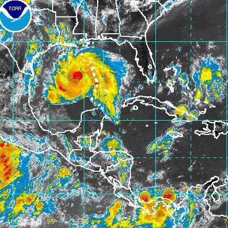
Re: Major Hurricane DEAN: (11am p161) Discussions, Analysis
You can see the deep convection around the eye...(Purple)

0 likes
-
cheezyWXguy

- Category 5
- Posts: 6282
- Joined: Mon Feb 13, 2006 12:29 am
- Location: Dallas, TX
Re: Major Hurricane DEAN: (11am p161) Discussions, Analysis
tolakram wrote:Question.
in this loop:
http://www.ssd.noaa.gov/goes/flt/t1/loop-vis.html
and in the link just posted you can see a blow off of convection, looks almost like an outflow boundry, heading NE. What exactly is that and what might cause it to happen?
It will not effect the storm...that left the storm a few hours ago, if it were to affect the storm, it would have done so by now, and I see no signs of that
0 likes
-
tolakram
- Admin

- Posts: 20184
- Age: 62
- Joined: Sun Aug 27, 2006 8:23 pm
- Location: Florence, KY (name is Mark)
Re: Major Hurricane DEAN: (11am p161) Discussions, Analysis
cheezyWXguy wrote:It will not effect the storm...that left the storm a few hours ago, if it were to affect the storm, it would have done so by now, and I see no signs of that
Right, but what was it?
0 likes
-
HURAKAN

- Professional-Met

- Posts: 46084
- Age: 39
- Joined: Thu May 20, 2004 4:34 pm
- Location: Key West, FL
- Contact:
TROPICAL CYCLONE GUIDANCE MESSAGE
NWS TPC/NATIONAL HURRICANE CENTER MIAMI FL
1826 UTC FRI AUG 17 2007
DISCLAIMER...NUMERICAL MODELS ARE SUBJECT TO LARGE ERRORS.
PLEASE REFER TO NHC OFFICIAL FORECASTS FOR TROPICAL CYCLONE
AND SUBTROPICAL CYCLONE INFORMATION.
ATLANTIC OBJECTIVE AIDS FOR
TROPICAL CYCLONE DEAN (AL042007) 20070817 1800 UTC
...00 HRS... ...12 HRS... ...24 HRS. .. ...36 HRS...
070817 1800 070818 0600 070818 1800 070819 0600
LAT LON LAT LON LAT LON LAT LON
BAMS 14.8N 63.6W 15.6N 67.5W 16.5N 71.1W 16.9N 74.6W
BAMD 14.8N 63.6W 15.7N 66.8W 16.7N 70.0W 17.5N 73.0W
BAMM 14.8N 63.6W 15.6N 67.1W 16.5N 70.6W 17.1N 73.8W
LBAR 14.8N 63.6W 15.5N 67.1W 16.4N 70.7W 17.5N 74.3W
SHIP 110KTS 120KTS 124KTS 129KTS
DSHP 110KTS 120KTS 124KTS 129KTS
...48 HRS... ...72 HRS... ...96 HRS. .. ..120 HRS...
070819 1800 070820 1800 070821 1800 070822 1800
LAT LON LAT LON LAT LON LAT LON
BAMS 17.8N 77.8W 18.6N 83.8W 20.4N 89.5W 22.9N 94.8W
BAMD 18.2N 76.1W 19.2N 82.5W 20.4N 89.4W 22.2N 95.5W
BAMM 17.8N 77.1W 18.8N 83.5W 20.0N 89.8W 21.9N 95.3W
LBAR 18.6N 77.9W 20.3N 84.5W 20.2N 89.6W .0N .0W
SHIP 130KTS 132KTS 124KTS 120KTS
DSHP 111KTS 116KTS 97KTS 93KTS
...INITIAL CONDITIONS...
LATCUR = 14.8N LONCUR = 63.6W DIRCUR = 280DEG SPDCUR = 19KT
LATM12 = 14.2N LONM12 = 59.8W DIRM12 = 276DEG SPDM12 = 19KT
LATM24 = 13.8N LONM24 = 55.5W
WNDCUR = 110KT RMAXWD = 15NM WNDM12 = 85KT
CENPRS = 961MB OUTPRS = 1010MB OUTRAD = 200NM SDEPTH = D
RD34NE = 120NM RD34SE = 100NM RD34SW = 50NM RD34NW = 160NM
0 likes
-
wxfollower
Re: Major Hurricane DEAN: (11am p161) Discussions, Analysis
Has a cane ever turned where the models never indicated it would?
0 likes
-
HURAKAN
- Professional-Met
- Posts: 46084
- Age: 39
- Joined: Thu May 20, 2004 4:34 pm
- Location: Key West, FL
- Contact:
TROPICAL CYCLONE GUIDANCE MESSAGE
NWS TPC/NATIONAL HURRICANE CENTER MIAMI FL
1826 UTC FRI AUG 17 2007
DISCLAIMER...NUMERICAL MODELS ARE SUBJECT TO LARGE ERRORS.
PLEASE REFER TO NHC OFFICIAL FORECASTS FOR TROPICAL CYCLONE
AND SUBTROPICAL CYCLONE INFORMATION.
ATLANTIC OBJECTIVE AIDS FOR
TROPICAL CYCLONE DEAN (AL042007) 20070817 1800 UTC
...00 HRS... ...12 HRS... ...24 HRS. .. ...36 HRS...
070817 1800 070818 0600 070818 1800 070819 0600
LAT LON LAT LON LAT LON LAT LON
BAMS 14.8N 63.6W 15.6N 67.5W 16.5N 71.1W 16.9N 74.6W
BAMD 14.8N 63.6W 15.7N 66.8W 16.7N 70.0W 17.5N 73.0W
BAMM 14.8N 63.6W 15.6N 67.1W 16.5N 70.6W 17.1N 73.8W
LBAR 14.8N 63.6W 15.5N 67.1W 16.4N 70.7W 17.5N 74.3W
SHIP 110KTS 120KTS 124KTS 129KTS
DSHP 110KTS 120KTS 124KTS 129KTS
...48 HRS... ...72 HRS... ...96 HRS. .. ..120 HRS...
070819 1800 070820 1800 070821 1800 070822 1800
LAT LON LAT LON LAT LON LAT LON
BAMS 17.8N 77.8W 18.6N 83.8W 20.4N 89.5W 22.9N 94.8W
BAMD 18.2N 76.1W 19.2N 82.5W 20.4N 89.4W 22.2N 95.5W
BAMM 17.8N 77.1W 18.8N 83.5W 20.0N 89.8W 21.9N 95.3W
LBAR 18.6N 77.9W 20.3N 84.5W 20.2N 89.6W .0N .0W
SHIP 130KTS 132KTS 124KTS 120KTS
DSHP 111KTS 116KTS 97KTS 93KTS
...INITIAL CONDITIONS...
LATCUR = 14.8N LONCUR = 63.6W DIRCUR = 280DEG SPDCUR = 19KT
LATM12 = 14.2N LONM12 = 59.8W DIRM12 = 276DEG SPDM12 = 19KT
LATM24 = 13.8N LONM24 = 55.5W
WNDCUR = 110KT RMAXWD = 15NM WNDM12 = 85KT
CENPRS = 961MB OUTPRS = 1010MB OUTRAD = 200NM SDEPTH = D
RD34NE = 120NM RD34SE = 100NM RD34SW = 50NM RD34NW = 160NM
NWS TPC/NATIONAL HURRICANE CENTER MIAMI FL
1826 UTC FRI AUG 17 2007
DISCLAIMER...NUMERICAL MODELS ARE SUBJECT TO LARGE ERRORS.
PLEASE REFER TO NHC OFFICIAL FORECASTS FOR TROPICAL CYCLONE
AND SUBTROPICAL CYCLONE INFORMATION.
ATLANTIC OBJECTIVE AIDS FOR
TROPICAL CYCLONE DEAN (AL042007) 20070817 1800 UTC
...00 HRS... ...12 HRS... ...24 HRS. .. ...36 HRS...
070817 1800 070818 0600 070818 1800 070819 0600
LAT LON LAT LON LAT LON LAT LON
BAMS 14.8N 63.6W 15.6N 67.5W 16.5N 71.1W 16.9N 74.6W
BAMD 14.8N 63.6W 15.7N 66.8W 16.7N 70.0W 17.5N 73.0W
BAMM 14.8N 63.6W 15.6N 67.1W 16.5N 70.6W 17.1N 73.8W
LBAR 14.8N 63.6W 15.5N 67.1W 16.4N 70.7W 17.5N 74.3W
SHIP 110KTS 120KTS 124KTS 129KTS
DSHP 110KTS 120KTS 124KTS 129KTS
...48 HRS... ...72 HRS... ...96 HRS. .. ..120 HRS...
070819 1800 070820 1800 070821 1800 070822 1800
LAT LON LAT LON LAT LON LAT LON
BAMS 17.8N 77.8W 18.6N 83.8W 20.4N 89.5W 22.9N 94.8W
BAMD 18.2N 76.1W 19.2N 82.5W 20.4N 89.4W 22.2N 95.5W
BAMM 17.8N 77.1W 18.8N 83.5W 20.0N 89.8W 21.9N 95.3W
LBAR 18.6N 77.9W 20.3N 84.5W 20.2N 89.6W .0N .0W
SHIP 130KTS 132KTS 124KTS 120KTS
DSHP 111KTS 116KTS 97KTS 93KTS
...INITIAL CONDITIONS...
LATCUR = 14.8N LONCUR = 63.6W DIRCUR = 280DEG SPDCUR = 19KT
LATM12 = 14.2N LONM12 = 59.8W DIRM12 = 276DEG SPDM12 = 19KT
LATM24 = 13.8N LONM24 = 55.5W
WNDCUR = 110KT RMAXWD = 15NM WNDM12 = 85KT
CENPRS = 961MB OUTPRS = 1010MB OUTRAD = 200NM SDEPTH = D
RD34NE = 120NM RD34SE = 100NM RD34SW = 50NM RD34NW = 160NM
0 likes

Re: Hurricane DEAN: Global Models
Jeff Masters blog update is up. Which model is best is all clear as mud now right since the answer seems to be "it depends", some are good some times, not others, and, oh yeah, look at their spread on Dean:
The "big four" models are plotted on wunderground.com's computer model page for Dean, (along with the inferior BAMM model, which is plotted since it is always available quickly, and has done well at longer range forecasts in the past). We do not get tracking points for the ECMWF or HWRF models at this point, so you'll have to go the raw plots to see those forecasts. Note that three of the "big four" models performed well in 2006, with the GFDL and GFS performing the best. The UKMET had a very poor showing in the Atlantic in 2006. However, the UKMET was the best-performing model in the Eastern Pacific in 2006, along with the GFDL and BAMM models.
The European Center's model (ECMWF) outperformed the "big four" consensus models for 72, 96, and 120 hours forecasts in the Atlantic. However, the ECMWF model was generally not available in time to be used by forecasters. Efforts are being made to make the ECMWF available in a more timely fashion for the 2007 season, which would be a big help. We also have the new HWRF (Hurricane Weather Research Forecast) model this year. In tests done on a number of hurricanes for past years, the HWRF performed about as well as the GFDL (Figure 2).
0 likes
-
chadtm80
Re: Major Hurricane DEAN: (11am p161) Discussions, Analysis
NOT AN OFFICIAL MAP.. JUST A RENDERING. and a cheezy one at that
we were in chat and someone brought up that FNC was going to be imposing dean in the GOM to see what it would look like.. So whiped this up while in chat.. Ignore the islands that are now in the gulf too though
we were in chat and someone brought up that FNC was going to be imposing dean in the GOM to see what it would look like.. So whiped this up while in chat.. Ignore the islands that are now in the gulf too though
0 likes

Re: Major Hurricane DEAN: (11am p161) Discussions, Analysis
wxfollower wrote:Has a cane ever turned where the models never indicated it would?
yes...off the top of my head, check out what all the models except GFDL said about katrina shortly before the Florida landfall but i am sure others will have much better examples especially when you get more than 3 days out
0 likes
-
gboudx

- S2K Supporter
- Posts: 4090
- Joined: Thu Sep 04, 2003 1:39 pm
- Location: Rockwall, Tx but from Harvey, La
Re: Major Hurricane DEAN: (11am p161) Discussions, Analysis
wxfollower wrote:Has a cane ever turned where the models never indicated it would?
2 years ago. You might remember it. Storm named Katrina. Models never brought it to SELA until about 1.5-2 days before landfall.
0 likes
-
Derek Ortt
Re: Hurricane Dean Forecasts in AF
viewtopic.php?f=29&t=97174
feel free to hate me as I am now going 130KT for Jamaica, cat 5 in NW Carib, and cat 4 in WGOM
feel free to hate me as I am now going 130KT for Jamaica, cat 5 in NW Carib, and cat 4 in WGOM
0 likes
-
Stormcenter
- S2K Supporter
- Posts: 6689
- Joined: Wed Sep 03, 2003 11:27 am
- Location: Houston, TX
Re: Major Hurricane DEAN: (11am p161) Discussions, Analysis
chadtm80 wrote:NOT AN OFFICIAL MAP.. JUST A RENDERING. and a cheezy one at that
we were in chat and someone brought up that FNC was going to be imposing dean in the GOM to see what it would look like.. So whiped this up while in chat.. Ignore the islands that are now in the gulf too though
I don't like that image at all.
0 likes
-
cheezyWXguy
- Category 5
- Posts: 6282
- Joined: Mon Feb 13, 2006 12:29 am
- Location: Dallas, TX
Re:
calamity wrote:Here's the latest--enhanced--visible.

I just found my new avatar, but i forgot how to edit my profile...i know there used to be a link you could go to, but i cant remember where it is
0 likes
-
PTrackerLA

- Category 5
- Posts: 5281
- Age: 42
- Joined: Thu Oct 10, 2002 8:40 pm
- Location: Lafayette, LA
Re: Hurricane DEAN: Global Models
I've been following storms for many years and FWIW the GFDL always seems to be one of the best performers. I just can't figure out the differences between the GFS and GFDL.
0 likes
-
wxfollower
Re: Major Hurricane DEAN: (11am p161) Discussions, Analysis
I know when Katrina went over FL, it started heading more south and then bam North... Just wondering if this would do the same, since strong storms make their own environment...
0 likes
Who is online
Users browsing this forum: No registered users and 31 guests