ATL: TROPICAL LOW ex-FRED (ex-07L)
Moderator: S2k Moderators
-
ozonepete
- Professional-Met

- Posts: 4743
- Joined: Mon Sep 07, 2009 3:23 pm
- Location: From Ozone Park, NYC / Now in Brooklyn, NY
Re:
gatorcane wrote:Hi Ozonepete things have changed in 6 hours since you have posted. It is drifting SSE it looks like and will eventually track WNW with a bend West as most of the models show. It won't be shooting of the the Northeast.
Bravo to the models, not sure how they will be wrong here. If anything maybe it will track more left.
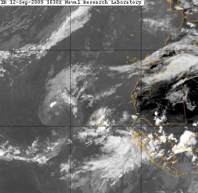
Hi Gatorcane. Yeah I really blew that one - I should never have tried to determine where the LLC is without a visible image or some decent microwave. I was pretty certain the whole package was going NE after looking at the IR sat and CIMSS charts. I also judged it just before the next image which made it clear that the whole top got sheared off to the NE but the LLC stayed behind. I especially retract what I said about the models. So far they still have done great on the track. Oh well, I'll get some BBQ sauce for my crow.
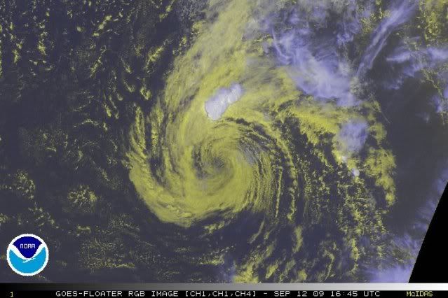
Meanwhile, the latest RGB satellite shows shallow Fred with his new haircut. Still stationary.
0 likes
-
ozonepete
- Professional-Met
- Posts: 4743
- Joined: Mon Sep 07, 2009 3:23 pm
- Location: From Ozone Park, NYC / Now in Brooklyn, NY
Re: ATL: TROPICAL STORM FRED (07L)
Look at the new disturbance coming in on his heels. He's got to start moving pretty soon. (And I thought I saw a west or northwest movement in the last few images.)
0 likes
-
UpTheCreek

- Category 1

- Posts: 397
- Age: 61
- Joined: Tue Aug 31, 2004 5:28 pm
- Location: Vassalboro, Maine
Re: ATL: TROPICAL STORM FRED (07L)
Lifesgud2 wrote:Guys,
Enough on Fred. Its done. Season is just about over Gator..Come on now!!!
Then why, pray tell, are you here reading threads about it? Should this regenerate down the road, I'll be sure to remind you of this post!
0 likes
-
JonathanBelles
- Professional-Met
- Posts: 11430
- Age: 35
- Joined: Sat Dec 24, 2005 9:00 pm
- Location: School: Florida State University (Tallahassee, FL) Home: St. Petersburg, Florida
- Contact:
Re: ATL: TROPICAL STORM FRED (07L)
Lifesgud2 wrote:Guys,
Enough on Fred. Its done. Season is just about over Gator..Come on now!!!
Season is only half way through.
0 likes


Re: ATL: TROPICAL STORM FRED (07L) - Computer Models
cycloneye wrote:12z GFDL gives extra-life to Fred.
http://moe.met.fsu.edu/cgi-bin/gfdltc2. ... =Animation
When is Fred going to head out to sea?
0 likes
-
cycloneye

- Admin

- Posts: 149219
- Age: 69
- Joined: Thu Oct 10, 2002 10:54 am
- Location: San Juan, Puerto Rico
Re: ATL:TROPICAL DEPRESSION FRED (ADVISORIES)
Last Advisory
000
WTNT32 KNHC 122035
TCPAT2
BULLETIN
TROPICAL DEPRESSION FRED ADVISORY NUMBER 21
NWS TPC/NATIONAL HURRICANE CENTER MIAMI FL AL072009
500 PM AST SAT SEP 12 2009
...FRED NOW A REMNANT LOW...
AT 500 PM AST...2100 UTC...THE CENTER OF FRED WAS LOCATED NEAR
LATITUDE 17.7 NORTH...LONGITUDE 33.7 WEST OR ABOUT 650 MILES...
1050 KM...WEST-NORTHWEST OF THE CAPE VERDE ISLANDS.
FRED IS DRIFTING TOWARD THE NORTH NEAR 1 MPH...2 KM/HR. A MOTION
TOWARD THE NORTH OR NORTH-NORTHWEST SHOULD BEGIN LATER TODAY OR
TONIGHT...FOLLOWED BY A TURN TOWARD NORTHWEST WITH SOME INCREASE IN
FORWARD SPEED ON SUNDAY.
MAXIMUM SUSTAINED WINDS HAVE DECREASED TO NEAR 35 MPH...55
KM/HR...WITH HIGHER GUSTS. FURTHER GRADUAL WEAKENING IS LIKELY...
AND FRED IS EXPECTED TO DISSIPATE IN A COUPLE OF DAYS.
ESTIMATED MINIMUM CENTRAL PRESSURE IS 1005 MB...29.68 INCHES.
...SUMMARY OF 500 PM AST INFORMATION...
LOCATION...17.7N 33.7W
MAXIMUM SUSTAINED WINDS...35 MPH
PRESENT MOVEMENT...NORTH OR 360 DEGREES AT 1 MPH
MINIMUM CENTRAL PRESSURE...1005 MB
THIS IS THE LAST PUBLIC ADVISORY ISSUED BY THE NATIONAL HURRICANE
CENTER ON FRED. ADDITIONAL INFORMATION ON THE REMNANT LOW CAN BE
FOUND IN HIGH SEAS FORECASTS ISSUED BY THE NATIONAL WEATHER
SERVICE...UNDER AWIPS HEADER NFDHSFAT1 AND WMO HEADER FZNT01 KWBC.
$$
FORECASTER KIMBERLAIN
TCDAT2
TROPICAL DEPRESSION FRED DISCUSSION NUMBER 21
NWS TPC/NATIONAL HURRICANE CENTER MIAMI FL AL072009
500 PM AST SAT SEP 12 2009
OTHER THAN A SHORT-LIVED PUFF OF DEEP CONVECTION WELL-REMOVED FROM
THE CIRCULATION CENTER...FRED IS NOW A SWIRL OF LOW CLOUDS DEVOID
OF DEEP CONVECTION. IN FACT...THERE HAS BEEN NO CENTRAL CONVECTION
ASSOCIATED WITH FRED SINCE ABOUT 0000 UTC....AND FRED IS NO LONGER
CLASSIFIABLE USING THE DVORAK TECHNIQUE. THE LACK OF DEEP
CONVECTION ALSO MEANS THAT FRED IS NO LONGER A TROPICAL CYCLONE...
AND IS NOW DECLARED A REMNANT LOW. THE INITIAL INTENSITY IS LOWERED
TO 30 KT...BASED UPON AN EARLIER QUIKSCAT PASS AND THE ASSUMPTION
THAT THERE HAS BEEN ADDITIONAL WEAKENING SINCE THAT TIME. WHAT
REMAINS OF FRED SHOULD BEGIN MOVING NORTHWESTWARD TO WEST-
NORTHWESTWARD WITH AN INCREASE IN FORWARD SPEED OVER THE NEXT 12 TO
24 HOURS...AS A LOW- TO MID-LEVEL RIDGE BUILDS TO ITS NORTH.
SEVERAL GLOBAL MODELS STILL MAINTAIN THE REMNANTS OF FRED DURING
THE FORECAST PERIOD. HOWEVER...A RATHER HOSTILE ENVIRONMENT ALONG
THE FORECAST TRACK SHOULD MAKE REGENERATION A SLIM POSSIBILITY.
THIS IS THE LAST NHC ADVISORY ON FRED. ADDITIONAL INFORMATION ON
THE REMNANT LOW CAN BE FOUND IN HIGH SEAS FORECASTS ISSUED BY THE
NATIONAL WEATHER SERVICE...UNDER AWIPS HEADER NFDHSFAT1 AND WMO
HEADER FZNT01 KWBC.
FORECAST POSITIONS AND MAX WINDS
INITIAL 12/2100Z 17.7N 33.7W 30 KT...REMNANT LOW
12HR VT 13/0600Z 18.1N 34.1W 25 KT...REMNANT LOW
24HR VT 13/1800Z 19.0N 35.1W 25 KT...REMNANT LOW
36HR VT 14/0600Z 19.8N 37.0W 25 KT...REMNANT LOW
48HR VT 14/1800Z 21.1N 39.6W 25 KT...REMNANT LOW
72HR VT 15/1800Z...DISSIPATED
$$
FORECASTER KIMBERLAIN
0 likes
-
AdamFirst

- S2K Supporter

- Posts: 2490
- Age: 36
- Joined: Thu Aug 14, 2008 10:54 am
- Location: Port Saint Lucie, FL
Re: ATL: TROPICAL STORM FRED (07L)
BULLETIN
TROPICAL DEPRESSION FRED ADVISORY NUMBER 21
NWS TPC/NATIONAL HURRICANE CENTER MIAMI FL AL072009
500 PM AST SAT SEP 12 2009
...FRED NOW A REMNANT LOW...

TROPICAL DEPRESSION FRED ADVISORY NUMBER 21
NWS TPC/NATIONAL HURRICANE CENTER MIAMI FL AL072009
500 PM AST SAT SEP 12 2009
...FRED NOW A REMNANT LOW...
0 likes
-
Brent
- S2K Supporter
- Posts: 38715
- Age: 37
- Joined: Sun May 16, 2004 10:30 pm
- Location: Tulsa Oklahoma
- Contact:
Re: ATL: TROPICAL DEPRESSION FRED (07L)
Bye-Bye Fred.
Can't believe there is nothing in the Atlantic or EPAC on September 12th.
Can't believe there is nothing in the Atlantic or EPAC on September 12th.
0 likes
-
ozonepete
- Professional-Met
- Posts: 4743
- Joined: Mon Sep 07, 2009 3:23 pm
- Location: From Ozone Park, NYC / Now in Brooklyn, NY
Re: ATL: TROPICAL DEPRESSION FRED (07L)
Brent wrote:Bye-Bye Fred.
Can't believe there is nothing in the Atlantic or EPAC on September 12th.
There will be soon enough. A large are of positive MJO (which moves from west to east) that's over the Pacific Ocean and North America will move over the Atlantic in a few days, and since there are still easterly waves being produced over Africa and moving out into the Atlantic, there's a good possibility of a couple more Cape Verde types. The season is far from over...
Here's the brief explanation from NOAA CMC:
"Daily IR and 200-hPa velocity potential anomalies (base period 1971-2000). Velocity potential anomalies are proportional to divergence with green (brown) contours corresponding to regions in which convection tends to be enhanced (suppressed)."
Green areas show enhanced, higher than normal upward motion at the upper levels of the atmosphere. This helps developing disturbances produce strong convection.

Last edited by ozonepete on Sat Sep 12, 2009 4:31 pm, edited 2 times in total.
0 likes
-
Evil Jeremy

- S2K Supporter
- Posts: 5463
- Age: 32
- Joined: Mon Apr 10, 2006 2:10 pm
- Location: Los Angeles, CA

-
Emmett_Brown

- Category 5

- Posts: 1433
- Joined: Wed Aug 24, 2005 9:10 pm
- Location: Sarasota FL
Re: ATL: TROPICAL DEPRESSION FRED (07L)
NHC seems to think that Fred is a real goner. I don't agree. Fred still has a pretty large surface circulation and vorticity extending up to 500mb. Granted, it is getting blasted by shear right now, but better conditions are 24- 48 hours away. No way this completely evaporates before then. I will go out on a limb and say that Fred survives, and mounts a comeback starting late Monday.
Many here will disagree with me, but I have seen much weaker vortexes spring to life in the past. About 36 hours from now, if this GFS shear forecast is even close to being correct, the shear should be easing:

My general reasoning for calling a Fred comeback:
1. Fred never made it past 20N. He may be pushed W or even W/SW around 18N for a while. Water will be getting warmer by the time it gets to 37W.
2. Shear will be lessening (as stated above)
3. As the ridge builds north of Fred, the increased gradient between the high to the north and Fred will cause the LLC to stay tight. Even with relatively high central pressure, the background pressure will be high enough to keep Fred spinning, which will create convergence, etc.
4. Fred still has some decent convergence as seen on cimms http://cimss.ssec.wisc.edu/tropic/real-time/atlantic/winds/archive/wg8conv-1.html, he should fire off intermittent convention bursts. As the shear lessens, these burst may take route enough to keep Fred alive.
So, to completely go out on a limb, I say that we should see advisories resume by Tuesday morning for Fred, as a TD or weak TS. After that, I wont venture to guess.
<StartMockery />
Disclaimer:
The posts in this forum are NOT official forecast and should not be used as such. They are just the opinion of the poster and may or may not be backed by sound meteorological data. They are NOT endorsed by any professional institution or storm2k.org. For official information, please refer to the NHC and NWS products.
Many here will disagree with me, but I have seen much weaker vortexes spring to life in the past. About 36 hours from now, if this GFS shear forecast is even close to being correct, the shear should be easing:
My general reasoning for calling a Fred comeback:
1. Fred never made it past 20N. He may be pushed W or even W/SW around 18N for a while. Water will be getting warmer by the time it gets to 37W.
2. Shear will be lessening (as stated above)
3. As the ridge builds north of Fred, the increased gradient between the high to the north and Fred will cause the LLC to stay tight. Even with relatively high central pressure, the background pressure will be high enough to keep Fred spinning, which will create convergence, etc.
4. Fred still has some decent convergence as seen on cimms http://cimss.ssec.wisc.edu/tropic/real-time/atlantic/winds/archive/wg8conv-1.html, he should fire off intermittent convention bursts. As the shear lessens, these burst may take route enough to keep Fred alive.
So, to completely go out on a limb, I say that we should see advisories resume by Tuesday morning for Fred, as a TD or weak TS. After that, I wont venture to guess.
<StartMockery />
Disclaimer:
The posts in this forum are NOT official forecast and should not be used as such. They are just the opinion of the poster and may or may not be backed by sound meteorological data. They are NOT endorsed by any professional institution or storm2k.org. For official information, please refer to the NHC and NWS products.
0 likes
-
CrazyC83
- Professional-Met
- Posts: 34315
- Joined: Tue Mar 07, 2006 11:57 pm
- Location: Deep South, for the first time!
Re: ATL: TROPICAL DEPRESSION FRED (07L)
Emmett_Brown wrote:NHC seems to think that Fred is a real goner. I don't agree. Fred still has a pretty large surface circulation and vorticity extending up to 500mb. Granted, it is getting blasted by shear right now, but better conditions are 24- 48 hours away. No way this completely evaporates before then. I will go out on a limb and say that Fred survives, and mounts a comeback starting late Monday.
Many here will disagree with me, but I have seen much weaker vortexes spring to life in the past. About 36 hours from now, if this GFS shear forecast is even close to being correct, the shear should be easing:
My general reasoning for calling a Fred comeback:
1. Fred never made it past 20N. He may be pushed W or even W/SW around 18N for a while. Water will be getting warmer by the time it gets to 37W.
2. Shear will be lessening (as stated above)
3. As the ridge builds north of Fred, the increased gradient between the high to the north and Fred will cause the LLC to stay tight. Even with relatively high central pressure, the background pressure will be high enough to keep Fred spinning, which will create convergence, etc.
4. Fred still has some decent convergence as seen on cimms http://cimss.ssec.wisc.edu/tropic/real-time/atlantic/winds/archive/wg8conv-1.html, he should fire off intermittent convention bursts. As the shear lessens, these burst may take route enough to keep Fred alive.
So, to completely go out on a limb, I say that we should see advisories resume by Tuesday morning for Fred, as a TD or weak TS. After that, I wont venture to guess.
<StartMockery />
Disclaimer:
The posts in this forum are NOT official forecast and should not be used as such. They are just the opinion of the poster and may or may not be backed by sound meteorological data. They are NOT endorsed by any professional institution or storm2k.org. For official information, please refer to the NHC and NWS products.
It remains Fred if it stays as it is now. If that wave picks it up and then the new system develops into a named storm, it becomes Grace.
0 likes
-
Emmett_Brown
- Category 5
- Posts: 1433
- Joined: Wed Aug 24, 2005 9:10 pm
- Location: Sarasota FL
Re: ATL: TROPICAL DEPRESSION FRED (07L)
CrazyC83 wrote:It remains Fred if it stays as it is now. If that wave picks it up and then the new system develops into a named storm, it becomes Grace.
Sorry for any confusion, but my post wasn't intended to address any interactions between Fred and the wave to its east. There is still ample room between the 2 systems, and Fred should start moving W by this time tomorrow, so I am confident that they will not merge.
0 likes
-
jlauderdal
- S2K Supporter
- Posts: 7240
- Joined: Wed May 19, 2004 5:46 am
- Location: NE Fort Lauderdale
- Contact:
-
ozonepete
- Professional-Met
- Posts: 4743
- Joined: Mon Sep 07, 2009 3:23 pm
- Location: From Ozone Park, NYC / Now in Brooklyn, NY
Re: ATL: TROPICAL DEPRESSION FRED (07L)
But in all fairness, I think he said GFS isn't good for shear.
0 likes
-
Just Joshing You

- Category 2

- Posts: 512
- Joined: Sat Nov 03, 2007 10:29 am
- Location: Nova Scotia
Surprised. Usually Derek Ortt takes the GFDL as the gospel.
Just a question, Ortt. Why do you consistently differ from the NHC in forecasts? I.e in intensity, track, factors, and conclusions usually are always different from the NHC. Do you try to be different than them, or are you being different for the sake of just.. being different?
Just a question, Ortt. Why do you consistently differ from the NHC in forecasts? I.e in intensity, track, factors, and conclusions usually are always different from the NHC. Do you try to be different than them, or are you being different for the sake of just.. being different?
0 likes
-
Derek Ortt
Re:
Just Joshing You wrote:Surprised. Usually Derek Ortt takes the GFDL as the gospel.
Just a question, Ortt. Why do you consistently differ from the NHC in forecasts? I.e in intensity, track, factors, and conclusions usually are always different from the NHC. Do you try to be different than them, or are you being different for the sake of just.. being different?
what in the world are you talking about? Usually, the forecasts are very similar (about 95% of the time they are similar). Reread the NHC and NWHHC archives
I do not use GFDL/HWRF in sheared cases because it has parametrized convection. Parametrized convection makes a model storm shear resistant. I've seen this numerous times in the MM5/ARW running at 12 vs 4km resolution. No more high res runs on Fred, though
0 likes
Who is online
Users browsing this forum: No registered users and 9 guests