ATL: SANDY - Remnants - Discussion

Moderator: S2k Moderators

Message
Author
User avatar
SFLcane
S2K Supporter
S2K Supporter
Posts: 10163
Age: 47
Joined: Sat Jun 05, 2010 1:44 pm
Location: Lake Worth Florida

Re:

#661 Postby SFLcane » Wed Oct 24, 2012 6:42 pm

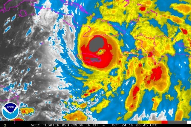
SouthDadeFish wrote:Cuba better look out. Phenomenal structure:

http://imageshack.us/a/img338/4966/2012 ... h18lsa.jpg


Oh my!
0 likes   

HurrMark
Category 2
Category 2
Posts: 769
Joined: Tue Aug 12, 2008 10:18 pm
Location: Somerville, MA

Re: Re:

#662 Postby HurrMark » Wed Oct 24, 2012 6:43 pm

ozonepete wrote:
Bocadude85 wrote:
HurrMark wrote:'Sandy' is now due south (and thus east) of the next forecast point. The further east it goes, the less Cuba it has to cross. Would be interested to see if that has an impact on the forecast.


Hurricanes do not move in a straight line. She wobbled NNW a few hours ago and is now wobbling NNE but if you smooth out the wobbles you will get a motion petty close to N. She appears to be right on the forecast track to me.


That's a really good answer. You have to look at the smoothed motion over at least 6 hours to get a true direction of motion because of the very short-term wobbles.


But at this juncture, with it so close to Cuba, any wobble will be that much more magnified...the coastline is essentially like a triangle with the "hypotenuse" getting closer to the "vertex" the further east you go. So if it wobbles west and makes landfall at 77W, it would have to go about 120 miles to cross the island vs. a wobble east to 76W, where it would just need to go about 70 miles...that could make a difference of the intensity when it reemerges.

On the flip side, the topography is higher the further east you go, so that could offset (and then some) the effect of less land required to cross. But if you look at a topographic map, there is an small area roughly around 76W where a northward traversing storm would have relatively flat terrain to cross...it will be interesting to see how this pans out...
Last edited by HurrMark on Wed Oct 24, 2012 6:46 pm, edited 1 time in total.
0 likes   

User avatar
galaxy401
Category 5
Category 5
Posts: 2419
Age: 30
Joined: Sat Aug 25, 2012 9:04 pm
Location: Casa Grande, Arizona

#663 Postby galaxy401 » Wed Oct 24, 2012 6:43 pm

Might be a cat 2 now. Got to see when recon gets there. Hope there wasn't a lot of damage in Jamaica!
0 likes   
Got my eyes on moving right into Hurricane Alley: Florida.

User avatar
AdamFirst
S2K Supporter
S2K Supporter
Posts: 2491
Age: 36
Joined: Thu Aug 14, 2008 10:54 am
Location: Port Saint Lucie, FL

Re: ATL: SANDY - Hurricane - Discussion

#664 Postby AdamFirst » Wed Oct 24, 2012 6:52 pm

SUMMARY OF 800 PM EDT...0000 UTC...INFORMATION
----------------------------------------------
LOCATION...18.7N 76.4W
ABOUT 60 MI...95 KM NNE OF KINGSTON JAMAICA
ABOUT 115 MI...185 KM SW OF GUANTANAMO CUBA
MAXIMUM SUSTAINED WINDS...85 MPH...135 KM/H
PRESENT MOVEMENT...N OR 10 DEGREES AT 14 MPH...22 KM/H
MINIMUM CENTRAL PRESSURE...968 MB...28.58 INCHES


Conservative estimate IMO
waiting for recon
0 likes   
Dolphins Marlins Canes Golden Panthers HEAT
Andrew 1992 - Irene 1999 - Frances 2004 - Jeanne 2004 - Wilma 2005 - Fay 2008 - Isaac 2012 - Matthew 2016 - Irma 2017 - Dorian 2019 - Ian 2022 - Nicole 2022 - Milton 2024

Nate-Gillson
Tropical Storm
Tropical Storm
Posts: 133
Age: 39
Joined: Sun Aug 22, 2004 8:27 pm
Location: Cedar Rapids, Iowa

#665 Postby Nate-Gillson » Wed Oct 24, 2012 6:52 pm

I wouldn't be surprised if Sandy is already a borderline cat 3, much less a cat 4.
0 likes   

User avatar
Weatherguy173
Tropical Storm
Tropical Storm
Posts: 148
Age: 31
Joined: Wed Aug 01, 2012 10:55 pm
Location: Short Hills NJ

Re:

#666 Postby Weatherguy173 » Wed Oct 24, 2012 6:53 pm

Nate-Gillson wrote:I wouldn't be surprised if Sandy is already a borderline cat 3, much less a cat 4.


still cat 1 - but waiting for recon aircraft i think
0 likes   
Nothing I say is intended to be a forecast; it's only food for thought and friendly advice!

User avatar
bahamaswx
Category 5
Category 5
Posts: 1542
Joined: Sat Sep 13, 2003 1:11 am
Location: Georgetown, Bahamas

Re: ATL: SANDY - Hurricane - Discussion

#667 Postby bahamaswx » Wed Oct 24, 2012 6:56 pm

Maybe winds haven't caught up yet, but with a structure like that the pressure has to have dropped more than just a few mbs.
0 likes   

CrazyC83
Professional-Met
Professional-Met
Posts: 34002
Joined: Tue Mar 07, 2006 11:57 pm
Location: Deep South, for the first time!

#668 Postby CrazyC83 » Wed Oct 24, 2012 6:57 pm

It may be becoming a monster?

UW - CIMSS
ADVANCED DVORAK TECHNIQUE
ADT-Version 8.1.3
Tropical Cyclone Intensity Algorithm

----- Current Analysis -----
Date : 24 OCT 2012 Time : 224500 UTC
Lat : 18:30:33 N Lon : 76:22:38 W


CI# /Pressure/ Vmax
5.4 / 956.8mb/ 99.6kt


Final T# Adj T# Raw T#
5.4 6.4 6.5

Estimated radius of max. wind based on IR :N/A km

Center Temp : -43.5C Cloud Region Temp : -76.5C

Scene Type : EYE

Positioning Method : SPIRAL ANALYSIS

Ocean Basin : ATLANTIC
Dvorak CI > MSLP Conversion Used : ATLANTIC

Tno/CI Rules : Constraint Limits : 1.7T/6hr
Weakening Flag : OFF
Rapid Dissipation Flag : OFF

C/K/Z MSLP Estimate Inputs :
- Average 34 knot radii : 90km
- Environmental MSLP : 1007mb

Satellite Viewing Angle : 21.7 degrees
0 likes   

jlauderdal
S2K Supporter
S2K Supporter
Posts: 7183
Joined: Wed May 19, 2004 5:46 am
Location: NE Fort Lauderdale
Contact:

Re: ATL: SANDY - Hurricane - Discussion

#669 Postby jlauderdal » Wed Oct 24, 2012 6:58 pm

Due to Hurricane Sandy, all Palm Beach County public schools will release students three hours early on Thursday, with no after school or evening activities, and all schools will be closed on Friday.

Broward was already scheduled to be closed friday due to teachers workday.

Based on that recent satellite presentation dade county wont be far behind.
0 likes   

User avatar
cycloneye
Admin
Admin
Posts: 145330
Age: 68
Joined: Thu Oct 10, 2002 10:54 am
Location: San Juan, Puerto Rico

Re: ATL: SANDY - Hurricane - Discussion

#670 Postby cycloneye » Wed Oct 24, 2012 6:59 pm

If recon finds much stronger winds I think a Special Advisory may be comming.
0 likes   
Visit the Caribbean-Central America Weather Thread where you can find at first post web cams,radars
and observations from Caribbean basin members Click Here

CrazyC83
Professional-Met
Professional-Met
Posts: 34002
Joined: Tue Mar 07, 2006 11:57 pm
Location: Deep South, for the first time!

Re: ATL: SANDY - Hurricane - Discussion

#671 Postby CrazyC83 » Wed Oct 24, 2012 7:00 pm

cycloneye wrote:If recon finds much stronger winds I think a Special Advisory may be comming.


I would think so too around 8:30 pm.
0 likes   

WeatherOrKnot
Tropical Depression
Tropical Depression
Posts: 80
Joined: Fri Sep 02, 2011 10:24 am

Re: ATL: SANDY - Hurricane - Discussion

#672 Postby WeatherOrKnot » Wed Oct 24, 2012 7:10 pm

Wind and rain is already picking up here in pbc.
0 likes   

CrazyC83
Professional-Met
Professional-Met
Posts: 34002
Joined: Tue Mar 07, 2006 11:57 pm
Location: Deep South, for the first time!

#673 Postby CrazyC83 » Wed Oct 24, 2012 7:12 pm

From calculating and extrapolating, I am going to guess the pressure in this pass will be about 955mb.
0 likes   

ozonepete
Professional-Met
Professional-Met
Posts: 4743
Joined: Mon Sep 07, 2009 3:23 pm
Location: From Ozone Park, NYC / Now in Brooklyn, NY

Re: ATL: SANDY - Hurricane - Discussion

#674 Postby ozonepete » Wed Oct 24, 2012 7:17 pm

cycloneye wrote:If recon finds much stronger winds I think a Special Advisory may be comming.


Could be. All I can say is that is a really impressive satellite presentation. The symmetry and small eye embedded perfectly is amazing. This is really bombing out. I didn't believe cat 2 before but now I do. Looks like Jamaica had virtually no weakening effect on it.

Image
0 likes   

CrazyC83
Professional-Met
Professional-Met
Posts: 34002
Joined: Tue Mar 07, 2006 11:57 pm
Location: Deep South, for the first time!

#675 Postby CrazyC83 » Wed Oct 24, 2012 7:20 pm

24/2345 UTC 18.7N 76.3W T5.5/5.5 SANDY

Will Recon find similar? Second major of 2012?
0 likes   

User avatar
cycloneye
Admin
Admin
Posts: 145330
Age: 68
Joined: Thu Oct 10, 2002 10:54 am
Location: San Juan, Puerto Rico

Re: ATL: SANDY - Hurricane - Discussion

#676 Postby cycloneye » Wed Oct 24, 2012 7:22 pm

Wow!!

001430 1837N 07615W 6969 02856 9655 +156 +096 233090 093 069 001 00
001500 1836N 07614W 6970 02883 9687 +152 +076 230095 096 070 001 00
001530 1835N 07613W 6965 02905 9714 +147 +068 230094 095 068 000 00
0 likes   
Visit the Caribbean-Central America Weather Thread where you can find at first post web cams,radars
and observations from Caribbean basin members Click Here

User avatar
AdamFirst
S2K Supporter
S2K Supporter
Posts: 2491
Age: 36
Joined: Thu Aug 14, 2008 10:54 am
Location: Port Saint Lucie, FL

Re: ATL: SANDY - Hurricane - Discussion

#677 Postby AdamFirst » Wed Oct 24, 2012 7:22 pm

Recon found 96kt flight level with 961 pressure


In the southeast quadrant
0 likes   
Dolphins Marlins Canes Golden Panthers HEAT
Andrew 1992 - Irene 1999 - Frances 2004 - Jeanne 2004 - Wilma 2005 - Fay 2008 - Isaac 2012 - Matthew 2016 - Irma 2017 - Dorian 2019 - Ian 2022 - Nicole 2022 - Milton 2024

CrazyC83
Professional-Met
Professional-Met
Posts: 34002
Joined: Tue Mar 07, 2006 11:57 pm
Location: Deep South, for the first time!

Re: ATL: SANDY - Hurricane - Discussion

#678 Postby CrazyC83 » Wed Oct 24, 2012 7:23 pm

cycloneye wrote:Wow!!

001430 1837N 07615W 6969 02856 9655 +156 +096 233090 093 069 001 00
001500 1836N 07614W 6970 02883 9687 +152 +076 230095 096 070 001 00
001530 1835N 07613W 6965 02905 9714 +147 +068 230094 095 068 000 00


The SFMR from the NW quad also supports at least 80 kt. Given the pressure drop and the NE quad not yet sampled, I would put out a Tropical Cyclone Update with 85 kt, and increase further on the next pass. Pressure looks to be 962mb.
0 likes   

User avatar
Miami Storm Tracker
Category 4
Category 4
Posts: 910
Age: 67
Joined: Sun Jun 13, 2010 10:12 pm
Location: Key Largo, Fla.
Contact:

Re: ATL: SANDY - Hurricane - Discussion

#679 Postby Miami Storm Tracker » Wed Oct 24, 2012 7:23 pm

Wow,

As ozone stated amazing how this system has improved. Question now is how close will it get to S fla.
0 likes   

User avatar
lester
S2K Supporter
S2K Supporter
Posts: 1305
Age: 36
Joined: Sat Aug 27, 2005 5:21 pm
Location: Washington, DC
Contact:

Re: ATL: SANDY - Hurricane - Discussion

#680 Postby lester » Wed Oct 24, 2012 7:24 pm

cycloneye wrote:Wow!!

001430 1837N 07615W 6969 02856 9655 +156 +096 233090 093 069 001 00
001500 1836N 07614W 6970 02883 9687 +152 +076 230095 096 070 001 00
001530 1835N 07613W 6965 02905 9714 +147 +068 230094 095 068 000 00


that's 'only' in the SE quad apparently :eek:
0 likes   


Return to “2012”

Who is online

Users browsing this forum: No registered users and 6 guests