Fifty Rock wrote:Well the night was very busy out here. We finished the night with 6.11 inches of rain, with 3inches of that in just 40 minutes.
Where are you in relation to Albany? We got around 4.5 inches on 601 by North Prong.
Moderator: S2k Moderators

Fifty Rock wrote:Well the night was very busy out here. We finished the night with 6.11 inches of rain, with 3inches of that in just 40 minutes.


lukem wrote:Fifty Rock wrote:Well the night was very busy out here. We finished the night with 6.11 inches of rain, with 3inches of that in just 40 minutes.
Where are you in relation to Albany? We got around 4.5 inches on 601 by North Prong.

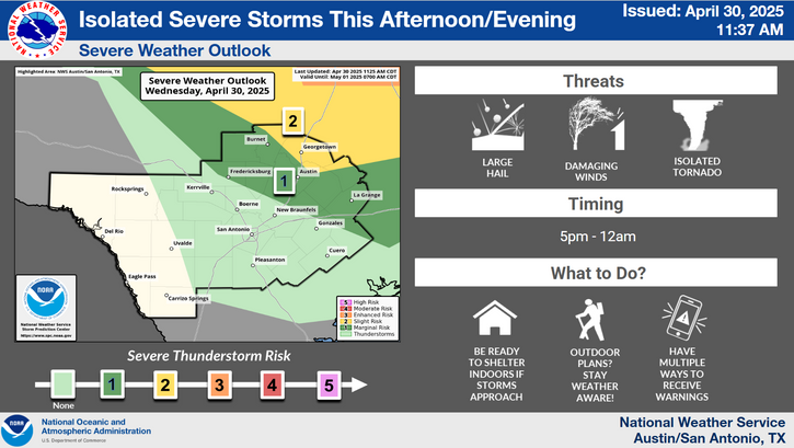
rwfromkansas wrote:DFW now gone from slight risk. Shocker lol


TomballEd wrote:rwfromkansas wrote:DFW now gone from slight risk. Shocker lol
OTOH, HRRR shows some marginally severe hail well NW to N of Houston, maybe our Aggie friends get some. Maybe an isolated hailer near San Antonio.
https://i.imgur.com/6SJiu6G.png

Stratton23 wrote:Love seeing the rain, but its making for very miserable driving conditions
Cpv17 wrote:Stratton23 wrote:Love seeing the rain, but its making for very miserable driving conditions
It’s mostly been missing me, but I’ve still managed to pick up about an inch and a half over the past week or so. Gladly take it.
Return to “USA & Caribbean Weather”
Users browsing this forum: Google [Bot], HockeyTx82, rwfromkansas, wxman22 and 159 guests