ATL: Tropical Depression Fay
Moderator: S2k Moderators
-
Weatherboy1

- Category 5

- Posts: 1190
- Age: 50
- Joined: Mon Jul 05, 2004 1:50 pm
- Location: Jupiter/Sarasota, FL

Re: ATL: Tropical Storm Fay South of Cuba
Dean4Storms wrote:Steve H. wrote:Well, if you think you've got this thing pegged to any degree, look at the 12Z Euro. Takes Fay off the east coast of Florida, then brings it back into central Florida heading west toward the panhandle. shhheeeesh.
The Euro has been all over the place on this one so discard it altogether for now.
actually it has been fairly consistent. Being on the east coast I have been keeping my eye on it.
0 likes
-
txwatcher91
- Category 5
- Posts: 1498
- Joined: Tue Aug 02, 2005 2:29 pm
Re:
gatorcane wrote:Wow look at sombrero Key of Marathon in the FL Keys....winds are on the increase....
Wind Direction (WDIR): E ( 100 deg true )
Wind Speed (WSPD): 22 kts
Wind Gust (GST): 24 kts
Uh oh, RI has begun, lol. Seriously though, this could really strengthen once in the GOM and N of Cuba.
0 likes

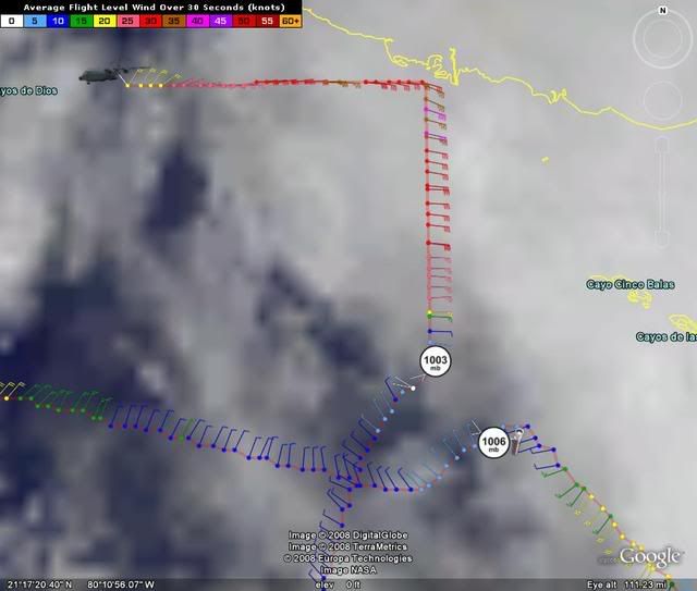
Re:
Aric Dunn wrote:URNT12 KNHC 171941
VORTEX DATA MESSAGE AL062008
A. 17/19:11:40Z
B. 20 deg 54 min N
079 deg 55 min W
C. 850 mb 1458 m
D. 26 kt
E. 196 deg 064 nm
F. 309 deg 015 kt
G. 209 deg 015 nm
H. 1003 mb
I. 16 C/ 1521 m
J. 18 C/ 1459 m
K. 16 C/ NA
L. NA
M. NA
N. 12345/ 8
O. 0.02 / NA nm
P. AF302 1306A FAY OB 12
MAX FL WIND 43 KT E QUAD 18:07:30 Z
PRELIMINARY
Yep 20.9N as expected, now we've got a good fix on the center the next recon pass will be far more interesting as we will get a good indication of the track in the short term.
0 likes
-
jaxfladude
- Category 5
- Posts: 1249
- Joined: Wed Aug 24, 2005 9:36 pm
- Location: Jacksonville, Fla
Re: Re:
marciacubed wrote:Steve wrote:>>The GDFL what do you think of this track?
Other than it hits SW FL instead of SE FL, that's been +/- my track since last Monday. So I think, if it verifies, I should be commissioned an honorary Administrator so I can ban lots of bad posters.
Steve
I hope I am not included in that group!!!
I KNOW I AM THE FIRST TO GO!!!
0 likes
-
Ed Mahmoud
Re: ATL: Tropical Storm Fay South of Cuba
53rd WRS flew Cuban airspace during Charley. Once upon a time, IIRC, Castro let the civilian WP-3D NOAA planes fly into Cuban airpspace, but not the USAFR. IIRC, Hugo Chavez has denied overflight permission a few years back.
But the info benefits Cuba as well, and without the solid backing of the old USSR (although I could see the old KGB hand Putin restoring the relationship) maybe whichever Castro actually runs things now is a touch less confrontational than he/his brother used to be.
But the info benefits Cuba as well, and without the solid backing of the old USSR (although I could see the old KGB hand Putin restoring the relationship) maybe whichever Castro actually runs things now is a touch less confrontational than he/his brother used to be.
0 likes
Re: ATL: Tropical Storm Fay South of Cuba
WV loop looks strange , weird cloud motion on the side of the ULL late in the loop. prob just me, but is this ULL behaving as forecast, seems to stop westward motion towar the end?
http://www.ssd.noaa.gov/goes/east/gmex/loop-wv.html
also cuban radar shows a center that is appearing to organize or back build
http://www.insmet.cu/asp/genesis.asp?TB ... AXw01a.gif
http://www.ssd.noaa.gov/goes/east/gmex/loop-wv.html
also cuban radar shows a center that is appearing to organize or back build
http://www.insmet.cu/asp/genesis.asp?TB ... AXw01a.gif
Last edited by cpdaman on Sun Aug 17, 2008 2:51 pm, edited 1 time in total.
0 likes
-
Shockwave
- Tropical Storm

- Posts: 167
- Joined: Fri Jul 25, 2008 7:33 am
- Location: Lafayette, TN
- Contact:
Re:
chris_fit wrote:From Sarasota County Government...
....At this time, a mandatory evacuation order is in place for all residents living in a mobile home. A voluntary evacuation is urged for all residents living in a low-lying area or on barrier islands. These evacuations may be upgraded Monday depending on storm conditions. Shelters will open after 5 p.m. Monday. Stay tuned to local media for the latest storm advisories. Currently, Sarasota County Schools will be open Monday, Aug. 18 along with all county and municipal offices. Continue to monitor local media and NOAA weather radio throughout today and tonight for the latest information.
http://www.scgov.net/stormcenter/stormcenterhome.asp
I would think with a mandatory evacuation (for some), schools would be closed? I guess they might have shelters opened up for the evacuation poeple who have no where to go.
0 likes
-
chris_fit

- Category 5
- Posts: 3261
- Age: 43
- Joined: Wed Sep 10, 2003 11:58 pm
- Location: Tampa Bay Area, FL
Re: Re:
Shockwave wrote:chris_fit wrote:From Sarasota County Government...
....At this time, a mandatory evacuation order is in place for all residents living in a mobile home. A voluntary evacuation is urged for all residents living in a low-lying area or on barrier islands. These evacuations may be upgraded Monday depending on storm conditions. Shelters will open after 5 p.m. Monday. Stay tuned to local media for the latest storm advisories. Currently, Sarasota County Schools will be open Monday, Aug. 18 along with all county and municipal offices. Continue to monitor local media and NOAA weather radio throughout today and tonight for the latest information.
http://www.scgov.net/stormcenter/stormcenterhome.asp
I would think with a mandatory evacuation (for some), schools would be closed? I guess they might have shelters opened up for the evacuation poeple who have no where to go.
Negative... schools are still open, see that link.
0 likes
-
jaxfladude
- Category 5
- Posts: 1249
- Joined: Wed Aug 24, 2005 9:36 pm
- Location: Jacksonville, Fla
Re: ATL: Tropical Storm Fay South of Cuba
It is the waiting game......well at least it is Mid Sun afternoon edt....
0 likes
Re: ATL: Tropical Storm Fay South of Cuba
Could be setting up for a slightly shorter pass over Cuba with night time d-max to give it legs to survive the trip.
- Tearing away to prepare house now.
- Tearing away to prepare house now.
0 likes

>>Yep 20.9N as expected
It's 20.54 so maybe not quite as expected.
----------------------------------------
I'm just kidding y'all. The only thing I would do differently than most of our fine mods and administrators would be to open up another forum called the Arena and suspend wobble-warriors, state-casters and whinecasters to fight it out there rather than on the regular boards until storm "x" passed. Nobody is automatically destined for that hypothetical forum, but depending on the storm, certain posters would be forced over there.
Steve
It's 20.54 so maybe not quite as expected.
----------------------------------------
I'm just kidding y'all. The only thing I would do differently than most of our fine mods and administrators would be to open up another forum called the Arena and suspend wobble-warriors, state-casters and whinecasters to fight it out there rather than on the regular boards until storm "x" passed.
Steve
Last edited by Steve on Sun Aug 17, 2008 2:53 pm, edited 1 time in total.
0 likes


-
gatorcane

- S2K Supporter

- Posts: 23708
- Age: 48
- Joined: Sun Mar 13, 2005 3:54 pm
- Location: Boca Raton, FL
is it me or does it "look" like its starting to jump NNW already now --- probably just an illusion with the mid-level clouds covering the low-level center I guess..
http://www.ssd.noaa.gov/goes/flt/t1/loop-vis.html
http://www.ssd.noaa.gov/goes/flt/t1/loop-vis.html
Last edited by gatorcane on Sun Aug 17, 2008 2:54 pm, edited 1 time in total.
0 likes
Re:
Steve wrote:>>Yep 20.9N as expected
It's 20.54 so maybe not quite as expected.
----------------------------------------
I'm just kidding y'all. The only thing I would do differently than most of our fine mods and administrators would be to open up another forum called the Arena and suspend wobble-warriors, state-casters and whinecasters to fight it out there rather than on the regular boards.
Steve
20.54 is 20.9
0 likes


Who is online
Users browsing this forum: No registered users and 9 guests