ATL GUSTAV: Tropical Depression - Discussion
Moderator: S2k Moderators
-
soonertwister
- Category 5

- Posts: 1091
- Joined: Mon Jun 16, 2003 2:52 pm
Re: Cat. 3 Hurricane Gustav in NW Caribbean Sea
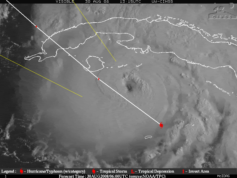
Looks like Havana is going to be in for some rather hellish weather in a few hours.
0 likes
-
O Town
- S2K Supporter

- Posts: 5205
- Age: 52
- Joined: Wed Sep 07, 2005 9:37 pm
- Location: Orlando, Florida 28°35'35"N 81°22'55"W
Re: Cat. 3 Hurricane Gustav in NW Caribbean Sea
crazycajuncane wrote::uarrow: but still falling in line. Look at the end of the loop it pushes over west. The jog was temporary as stated many times on the board this morning. The NHC expects the storm to resume a NW path.
Haven't had time to read over all the posts this morning. Just stating my observations.
Nice visible loop
0 likes


-
Harry Cane

- Tropical Low

- Posts: 33
- Joined: Tue Aug 21, 2007 11:23 pm
- Location: Asia
- Contact:
Re:
O Town wrote:Wow just taking my real first look at Gustav this AM.
While he does look good as expected, he sure seems to be alot further east than anticipated. By thisit looks like he is to the furthest N or E of the cone of error.
Thanks O town great information
0 likes
-
HURAKAN

- Professional-Met

- Posts: 46084
- Age: 39
- Joined: Thu May 20, 2004 4:34 pm
- Location: Key West, FL
- Contact:
Re:
WhirlWind wrote:I have a question, with the cone looking so far away from Fl. why have they issuded warnings and watches for the Keys? Just asking and cotinuing to learn...Thanks
WhirlWind

TS winds will extend to the lower keys as Gustav passes over Cuba.
0 likes
-
Texashawk

- Category 2

- Posts: 579
- Joined: Tue Aug 14, 2007 1:50 am
- Location: Missouri City, TX (Houston)
Re: Cat. 3 Hurricane Gustav in NW Caribbean Sea
cycloneye wrote:

You guys do realize, due to the somewhat oblique angle of the track vis a vis the coastline it would only take a 2 degree shift in track to affect Texas and a 3.5 degree shift to affect Houston (assuming a straight-line shift) It's way too early to drop your guard if you live in Texas and I hope people are still paying attention!
Last edited by Texashawk on Sat Aug 30, 2008 10:09 am, edited 1 time in total.
0 likes

-
Sabanic

- Category 2
- Posts: 683
- Age: 66
- Joined: Wed Aug 01, 2007 7:01 am
- Location: Mobile, AL
- Contact:
Re: Cat. 3 Hurricane Gustav in NW Caribbean Sea
Texashawk wrote:cycloneye wrote:
You guys do realize, due to the angle of the track vis a vis the coastline it would only take a 2 degree shift in track to affect Texas and a 3.5 degree shift to affect Houston (assuming a straight-line shift) It's way too early to drop your guard if you live in Texas and I hope people are still paying attention!
Exactly TexasHawk, and the same goes for the other side MGC/SWAL particularly being on the Eastern side. Storm surge, and the strongest winds. Mobile is 100 miles from NOLA as the crow flies
0 likes

-
Texashawk
- Category 2
- Posts: 579
- Joined: Tue Aug 14, 2007 1:50 am
- Location: Missouri City, TX (Houston)
Re: Cat. 3 Hurricane Gustav in NW Caribbean Sea
Sabanic wrote:Texashawk wrote:cycloneye wrote:
You guys do realize, due to the angle of the track vis a vis the coastline it would only take a 2 degree shift in track to affect Texas and a 3.5 degree shift to affect Houston (assuming a straight-line shift) It's way too early to drop your guard if you live in Texas and I hope people are still paying attention!
Exactly TexasHawk, and the same goes for the other side MGC/SWAL particularly being on the Eastern side. Storm surge, and the strongest winds. Mobile is 100 miles from NOLA as the crow flies
Very true, Sabanic. I think, for the first time in my life, I hate that skinny black line!
0 likes
-
deltadog03

- Professional-Met
- Posts: 3580
- Joined: Tue Jul 05, 2005 6:16 pm
- Location: Macon, GA
Re: Cat. 3 Hurricane Gustav in NW Caribbean Sea
Looks like Gus is trying to run for that weakness
0 likes
-
GeneratorPower

- S2K Supporter
- Posts: 1648
- Age: 46
- Joined: Sun Dec 18, 2005 11:48 pm
- Location: Huntsville, AL
Re: Cat. 3 Hurricane Gustav in NW Caribbean Sea
deltadog03 wrote:Looks like Gus is trying to run for that weakness
Please elaborate.
0 likes
Re: Cat. 3 Hurricane Gustav in NW Caribbean Sea
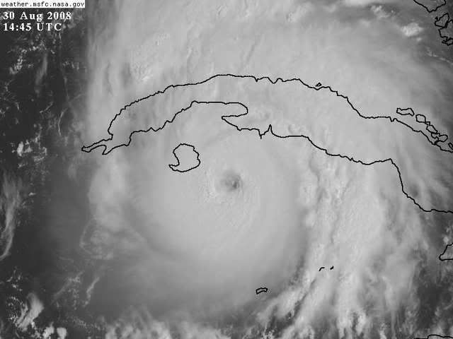
A look at "O-Towns" loop on the last page shows classic trochoidal wobbles. The sign of a strengthening storm.
0 likes
-
x-y-no

- Category 5
- Posts: 8359
- Age: 65
- Joined: Wed Aug 11, 2004 12:14 pm
- Location: Fort Lauderdale, FL
Re:
WhirlWind wrote:I have a question, with the cone looking so far away from Fl. why have they issuded warnings and watches for the Keys? Just asking and cotinuing to learn...Thanks
WhirlWind
Gustav has a large and still expanding wind field. Even if he goes exactly down the track, one can expect some TS gusts in Key West. Any track on the right side of the cone will bring sustained TS winds to the lower keys.
0 likes
Re: Re:
x-y-no wrote:WhirlWind wrote:I have a question, with the cone looking so far away from Fl. why have they issuded warnings and watches for the Keys? Just asking and cotinuing to learn...Thanks
WhirlWind
Gustav has a large and still expanding wind field. Even if he goes exactly down the track, one can expect some TS gusts in Key West. Any track on the right side of the cone will bring sustained TS winds to the lower keys.
i wonder if any flooding would occur in key west near time of high tide
0 likes
-
Just Joshing You

- Category 2
- Posts: 512
- Joined: Sat Nov 03, 2007 10:29 am
- Location: Nova Scotia
-
deltadog03
- Professional-Met
- Posts: 3580
- Joined: Tue Jul 05, 2005 6:16 pm
- Location: Macon, GA
Re: Cat. 3 Hurricane Gustav in NW Caribbean Sea
OLook back a couple of pages at the steering flow.
0 likes
-
Just Joshing You
- Category 2
- Posts: 512
- Joined: Sat Nov 03, 2007 10:29 am
- Location: Nova Scotia
Re: Re:
cpdaman wrote:x-y-no wrote:WhirlWind wrote:I have a question, with the cone looking so far away from Fl. why have they issuded warnings and watches for the Keys? Just asking and cotinuing to learn...Thanks
WhirlWind
Gustav has a large and still expanding wind field. Even if he goes exactly down the track, one can expect some TS gusts in Key West. Any track on the right side of the cone will bring sustained TS winds to the lower keys.
i wonder if any flooding would occur in key west near time of high tide
Probably won't have much time to build up a surge before passing them the keys.
0 likes

Re: Cat. 3 Hurricane Gustav in NW Caribbean Sea
I wish they'd recenter that storm relative floater. I e-mailed the site administrator earlier this morning but, so far, no dice.
Last edited by Agua on Sat Aug 30, 2008 10:21 am, edited 1 time in total.
0 likes
Who is online
Users browsing this forum: No registered users and 22 guests