
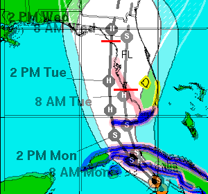
11am track and 5pm track over layed. You can see the track shift to the west wasn't that big, but it changed the landfall location (red line) dramatically.
Moderator: S2k Moderators

Extremeweatherguy wrote:I have added 2am times, and you can see just how slowly the NHC expects this thing to move...
The west coast could be in for an absolutely awful period of weather!


KWT wrote:Yep NHC track has only shifted a little but it makes a world of difference to landfall and may make a difference in terms of strength as well we shall see.
I think the current NHC track is about right, I don't think this will shift much more west than where its at now to be honest.


RL3AO wrote:
11am track and 5pm track over layed. You can see the track shift to the west wasn't that big, but it changed the landfall location (red line) dramatically.
KWT wrote:EWG, yep the NHC really have this only slowly moving northwards, would suggest a fairly long period of tropical storm force winds, I'd also imagine a big risk of tornadoes given the dirty side will remain over Florida throughout.
Aric Dunn wrote:center is clearly trying to tuck under that convection if it succeeds we should see soem intensification

Brent wrote:Track shifted west with delayed landfall:


TheRingo wrote:Does it seem like a jog to the east at the end of this run?
http://www.ssd.noaa.gov/goes/east/watl/loop-wv.html
I think that's the convection giving off a illusion, it has however REALLY slowed down. Might be an indication that it is about to turn N and maybe NNE soon.TheRingo wrote:Does it seem like a jog to the east at the end of this run?
http://www.ssd.noaa.gov/goes/east/watl/loop-wv.html
RL3AO wrote:
11am track and 5pm track over layed. You can see the track shift to the west wasn't that big, but it changed the landfall location (red line) dramatically.

johngaltfla wrote:RL3AO wrote:
11am track and 5pm track over layed. You can see the track shift to the west wasn't that big, but it changed the landfall location (red line) dramatically.
Nice comparison! If you can overlay the 2300 and 0500 paths on this, we might have a darned good idea of the final destination in 36 hours. As it sits now, if I lived anywhere from Bonita Beach to Crystal River my attention would be focused on her.
MiamiensisWx wrote:THE FORECAST TRACK SITUATION IS SIMILAR TO THAT OF HURRICANE CHARELY
FROM AUGUST 2004...IN THAT A SMALL CHANGE IN THE TRACK OF THE STORM
COULD MAKE A BIG DIFFERENCE IN THE EVETUAL LANDFALL LOCATION. THE
NHC WIND SPEED PROBABILITIES PRODUCT SHOWS ABOUT AN EQUAL CHANCE OF
HURRICANE-FORCE WINDS FOR THE ENTIRE WEST COAST OF THE FLORIDA
PENINSULA.
http://www.nhc.noaa.gov/text/refresh/MIATCDAT1+shtml/172105.shtml
Users browsing this forum: No registered users and 62 guests


