Trust those models and their text grid numbers are your own risk.
Texas Winter 2013-2014
Moderator: S2k Moderators
Forum rules
 The posts in this forum are NOT official forecast and should not be used as such. They are just the opinion of the poster and may or may not be backed by sound meteorological data. They are NOT endorsed by any professional institution or STORM2K.

The posts in this forum are NOT official forecast and should not be used as such. They are just the opinion of the poster and may or may not be backed by sound meteorological data. They are NOT endorsed by any professional institution or STORM2K.
-
Portastorm

- Storm2k Moderator

- Posts: 9955
- Age: 63
- Joined: Fri Jul 11, 2003 9:16 am
- Location: Round Rock, TX
- Contact:
Re: Texas Winter 2013-2014
How today's weather has developed in Texas ... and how poorly some of the models performed in underestimating the cold air, let along the vorticity of the short wave rolling through the state ... this should all clue you in to NOT model hug for what lies ahead. As Ntxw and srainhoutx have cautioned, we have two more systems after this one in the next seven days. And the one for later next week has some pretty large potential to create widespread misery over a lot of real estate.
Trust those models and their text grid numbers are your own risk.
Trust those models and their text grid numbers are your own risk.
0 likes
Any forecasts under my name are to be taken with a grain of salt. Get your best forecasts from the National Weather Service and National Hurricane Center.
-
SouthernMet

- Category 3

- Posts: 857
- Joined: Sun Aug 29, 2010 8:23 pm
- Location: fort worth, tx
Re: Texas Winter 2013-2014
Denton, Mineral Wells, Bridgeport all 29-31 degrees so accumulations on streets are starting now..
Decatur on the other hand is at 29degrees with a one
mile visibility & they have been getting precip for hours.
edit : (Power Emergency) Trenton & Whitewright - ALL POWER is out in Trenton & Whitewright. TXNM dose not anticipate restoration before 1pm.
Decatur on the other hand is at 29degrees with a one
mile visibility & they have been getting precip for hours.
edit : (Power Emergency) Trenton & Whitewright - ALL POWER is out in Trenton & Whitewright. TXNM dose not anticipate restoration before 1pm.
Last edited by SouthernMet on Sun Feb 02, 2014 11:32 am, edited 1 time in total.
0 likes
Nothing that SouthernMet posts, is an official forecast,nor does it reflect views of STORM2K.. SouthernMet is just adding to the great discussions on STORM2K.. Refer to NWS for official forecasts.
-
TheProfessor

- Professional-Met

- Posts: 3506
- Age: 29
- Joined: Tue Dec 03, 2013 10:56 am
- Location: Wichita, Kansas
Re:
gboudx wrote:Here's an update from McCauley:The winter storm approaches bringing a mix of rain/freezing rain/sleet/snow. Bridges and overpasses here in the Metroplex may get a little icy this afternoon, but as you can see, worse conditions will be to our north and northwest. Although temperatures are already near freezing here in the Metro, the temperatures aloft are running near 50 degrees. So as the rain falls, it will bring down some of this warmth, so do not expect a rapid fall in temperatures. It will all be over in the immediate DFW area before the sun goes down this evening.
But if that very heavy precip makes it to some place in the Metroplex, wouldn't that rapidly cool the air?
0 likes
An alumnus of The Ohio State University.
Your local National Weather Service office is your best source for weather information.
Your local National Weather Service office is your best source for weather information.
-
Portastorm
- Storm2k Moderator
- Posts: 9955
- Age: 63
- Joined: Fri Jul 11, 2003 9:16 am
- Location: Round Rock, TX
- Contact:
Re: Re:
TheProfessor wrote:gboudx wrote:Here's an update from McCauley:The winter storm approaches bringing a mix of rain/freezing rain/sleet/snow. Bridges and overpasses here in the Metroplex may get a little icy this afternoon, but as you can see, worse conditions will be to our north and northwest. Although temperatures are already near freezing here in the Metro, the temperatures aloft are running near 50 degrees. So as the rain falls, it will bring down some of this warmth, so do not expect a rapid fall in temperatures. It will all be over in the immediate DFW area before the sun goes down this evening.
But if that very heavy precip makes it to some place in the Metroplex, wouldn't that rapidly cool the air?
No, because the air immediately above the surface is much warmer, not much colder.
0 likes
Any forecasts under my name are to be taken with a grain of salt. Get your best forecasts from the National Weather Service and National Hurricane Center.
-
gboudx

- S2K Supporter

- Posts: 4090
- Joined: Thu Sep 04, 2003 1:39 pm
- Location: Rockwall, Tx but from Harvey, La
Re: Re:
TheProfessor wrote:gboudx wrote:Here's an update from McCauley:The winter storm approaches bringing a mix of rain/freezing rain/sleet/snow. Bridges and overpasses here in the Metroplex may get a little icy this afternoon, but as you can see, worse conditions will be to our north and northwest. Although temperatures are already near freezing here in the Metro, the temperatures aloft are running near 50 degrees. So as the rain falls, it will bring down some of this warmth, so do not expect a rapid fall in temperatures. It will all be over in the immediate DFW area before the sun goes down this evening.
But if that very heavy precip makes it to some place in the Metroplex, wouldn't that rapidly cool the air?
Not really. I've seen too many wintry events ruined by warm air being drawn down by heavy rain. I believe it depends on the depth of the warm nose. The deeper the warm nose the more likely it won't cool down enough. But someone correct me if I'm wrong.
0 likes
-
Portastorm
- Storm2k Moderator
- Posts: 9955
- Age: 63
- Joined: Fri Jul 11, 2003 9:16 am
- Location: Round Rock, TX
- Contact:
Re: Texas Winter 2013-2014
You're spot on, gboudx. Check out latest Tweet from @NWSFortWorth:
NWS Fort Worth @NWSFortWorth 47s
Aircraft data from DAL has temps 37-40 at 3000-7000ft. This is warm enough to keep all rain/fzra in the metroplex for a while. #txwx #dfwwx
NWS Fort Worth @NWSFortWorth 47s
Aircraft data from DAL has temps 37-40 at 3000-7000ft. This is warm enough to keep all rain/fzra in the metroplex for a while. #txwx #dfwwx
0 likes
Any forecasts under my name are to be taken with a grain of salt. Get your best forecasts from the National Weather Service and National Hurricane Center.
-
Meteorcane

- Category 2

- Posts: 559
- Joined: Thu Jul 21, 2011 6:49 am
- Location: North Platte Nebraska
Re: Re:
TheProfessor wrote:gboudx wrote:Here's an update from McCauley:The winter storm approaches bringing a mix of rain/freezing rain/sleet/snow. Bridges and overpasses here in the Metroplex may get a little icy this afternoon, but as you can see, worse conditions will be to our north and northwest. Although temperatures are already near freezing here in the Metro, the temperatures aloft are running near 50 degrees. So as the rain falls, it will bring down some of this warmth, so do not expect a rapid fall in temperatures. It will all be over in the immediate DFW area before the sun goes down this evening.
But if that very heavy precip makes it to some place in the Metroplex, wouldn't that rapidly cool the air?
There are two terms at play here, one is the evaporative cooling term that you mention, which if the subcloud layer was dry enough could produce cooling. The second term the one mentioned by McCauley is the vertical advection of temperature term. This term is usually not very significant unless significant updrafts/downdrafts are present. I doubt precip-induced downdrafts will be very strong in this case, however DT/DZ (change in temperature with height) is fairly large (and positive) in this case, which might make this term a little-larger and counteract the evaporative cooling affect.
0 likes
-
srainhoutx

- S2K Supporter
- Posts: 6919
- Age: 68
- Joined: Sun Jan 14, 2007 11:34 am
- Location: Haywood County, NC
- Contact:
Re: Texas Winter 2013-2014
.75 inches of sleet reported in Jacksboro (Jack County). Also FWD reports a light glazing of ice developing in the City of Denton.
0 likes
Carla/Alicia/Jerry(In The Eye)/Michelle/Charley/Ivan/Dennis/Katrina/Rita/Wilma/Ike/Harvey
Member: National Weather Association
Wx Infinity Forums
http://wxinfinity.com/index.php
Facebook.com/WeatherInfinity
Twitter @WeatherInfinity
Member: National Weather Association
Wx Infinity Forums
http://wxinfinity.com/index.php
Facebook.com/WeatherInfinity
Twitter @WeatherInfinity
-
Meteorcane
- Category 2
- Posts: 559
- Joined: Thu Jul 21, 2011 6:49 am
- Location: North Platte Nebraska
Re: Texas Winter 2013-2014
srainhoutx wrote:.75 inches of sleet reported in Jacksboro (Jack County). Also FWD reports a light glazing of ice developing in the City of Denton.
That high reflectivity band (which I assume is sleet based on radar classifcation) just to the W and NW of DFW looks nasty.
0 likes
-
srainhoutx
- S2K Supporter
- Posts: 6919
- Age: 68
- Joined: Sun Jan 14, 2007 11:34 am
- Location: Haywood County, NC
- Contact:
Re: Texas Winter 2013-2014
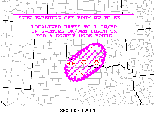
MESOSCALE DISCUSSION 0054
NWS STORM PREDICTION CENTER NORMAN OK
1009 AM CST SUN FEB 02 2014
AREAS AFFECTED...SWRN/S-CNTRL/CNTRL OK AND WRN NORTH TX
CONCERNING...HEAVY SNOW
VALID 021609Z - 021815Z
SUMMARY...SNOW WILL BE TAPERING OFF FROM NW TO SE INTO EARLY
AFTERNOON...THOUGH LOCALIZED SNOW RATES TO 1 INCH/HR MAY PERSIST IN
PARTS OF S-CNTRL OK AND WRN NORTH TX FOR A COUPLE MORE HOURS.
DISCUSSION...COMPOSITE RADAR IMAGERY AND SFC OBSERVATIONS CONTINUE
TO INDICATE THE EROSION OF THE NWRN EDGE OF THE ONGOING SRN-PLAINS
PRECIPITATION SHIELD. THIS IS OCCURRING AS A MID-LEVEL DRY SLOT
PRECEDING AN UPSTREAM SHORTWAVE IMPULSE -- EMERGING OVER THE TX S
PLAINS PER MOISTURE-CHANNEL IMAGERY -- IS OVERTAKING THE LEADING
WARM CONVEYOR STRUCTURE. AS SUCH...SNOW WILL CONTINUE TO TAPER OFF
FROM NW TO SE THROUGH THE MORNING...ENDING AROUND 17Z IN THE
OKLAHOMA CITY TO FORT SILL CORRIDOR...AND AROUND 1730Z-1800Z IN
NORMAN. FARTHER SOUTH INTO S-CNTRL OK AND WRN NORTH TX...SNOWFALL
RATES TO 1 INCH/HOUR WILL LIKELY PERSIST FOR THE REMAINDER OF THE
MORNING BEFORE TAPERING OFF IN RESPONSE TO MID-LEVEL DRYING EARLY
THIS AFTERNOON. ANY ONGOING SLEET ACROSS PARTS OF WRN NORTH TX
SHOULD CHANGE TO SNOW IN THE NEXT HOUR OR TWO AS DEEP ASCENT
PRECEDING THE TROUGH ADIABATICALLY COOLS THE ELEVATED WARM NOSE
SAMPLED BY THE 12Z FWD RAOB.
..COHEN.. 02/02/2014
ATTN...WFO...FWD...OUN...SJT...
0 likes
Carla/Alicia/Jerry(In The Eye)/Michelle/Charley/Ivan/Dennis/Katrina/Rita/Wilma/Ike/Harvey
Member: National Weather Association
Wx Infinity Forums
http://wxinfinity.com/index.php
Facebook.com/WeatherInfinity
Twitter @WeatherInfinity
Member: National Weather Association
Wx Infinity Forums
http://wxinfinity.com/index.php
Facebook.com/WeatherInfinity
Twitter @WeatherInfinity
-
srainhoutx
- S2K Supporter
- Posts: 6919
- Age: 68
- Joined: Sun Jan 14, 2007 11:34 am
- Location: Haywood County, NC
- Contact:
Re: Texas Winter 2013-2014
SJT reports 2.5 inches of snow in Anson (Jones County)
0 likes
Carla/Alicia/Jerry(In The Eye)/Michelle/Charley/Ivan/Dennis/Katrina/Rita/Wilma/Ike/Harvey
Member: National Weather Association
Wx Infinity Forums
http://wxinfinity.com/index.php
Facebook.com/WeatherInfinity
Twitter @WeatherInfinity
Member: National Weather Association
Wx Infinity Forums
http://wxinfinity.com/index.php
Facebook.com/WeatherInfinity
Twitter @WeatherInfinity
Re: Texas Winter 2013-2014
Just about over in San Angelo.....a little icing on some elevated surfaces but the roads were nice and warm from our 85 degrees the other day so no problems driving. Hope the end of week system brings some of the white stuff.
0 likes
-
TheProfessor
- Professional-Met
- Posts: 3506
- Age: 29
- Joined: Tue Dec 03, 2013 10:56 am
- Location: Wichita, Kansas
-
orangeblood
- S2K Supporter
- Posts: 3895
- Joined: Tue Dec 15, 2009 6:14 pm
- Location: Fort Worth, TX
Re: Texas Winter 2013-2014
srainhoutx wrote:MESOSCALE DISCUSSION 0054
NWS STORM PREDICTION CENTER NORMAN OK
1009 AM CST SUN FEB 02 2014
AREAS AFFECTED...SWRN/S-CNTRL/CNTRL OK AND WRN NORTH TX
CONCERNING...HEAVY SNOW
VALID 021609Z - 021815Z
SUMMARY...SNOW WILL BE TAPERING OFF FROM NW TO SE INTO EARLY
AFTERNOON...THOUGH LOCALIZED SNOW RATES TO 1 INCH/HR MAY PERSIST IN
PARTS OF S-CNTRL OK AND WRN NORTH TX FOR A COUPLE MORE HOURS.
DISCUSSION...COMPOSITE RADAR IMAGERY AND SFC OBSERVATIONS CONTINUE
TO INDICATE THE EROSION OF THE NWRN EDGE OF THE ONGOING SRN-PLAINS
PRECIPITATION SHIELD. THIS IS OCCURRING AS A MID-LEVEL DRY SLOT
PRECEDING AN UPSTREAM SHORTWAVE IMPULSE -- EMERGING OVER THE TX S
PLAINS PER MOISTURE-CHANNEL IMAGERY -- IS OVERTAKING THE LEADING
WARM CONVEYOR STRUCTURE. AS SUCH...SNOW WILL CONTINUE TO TAPER OFF
FROM NW TO SE THROUGH THE MORNING...ENDING AROUND 17Z IN THE
OKLAHOMA CITY TO FORT SILL CORRIDOR...AND AROUND 1730Z-1800Z IN
NORMAN. FARTHER SOUTH INTO S-CNTRL OK AND WRN NORTH TX...SNOWFALL
RATES TO 1 INCH/HOUR WILL LIKELY PERSIST FOR THE REMAINDER OF THE
MORNING BEFORE TAPERING OFF IN RESPONSE TO MID-LEVEL DRYING EARLY
THIS AFTERNOON. ANY ONGOING SLEET ACROSS PARTS OF WRN NORTH TX
SHOULD CHANGE TO SNOW IN THE NEXT HOUR OR TWO AS DEEP ASCENT
PRECEDING THE TROUGH ADIABATICALLY COOLS THE ELEVATED WARM NOSE
SAMPLED BY THE 12Z FWD RAOB.
..COHEN.. 02/02/2014
ATTN...WFO...FWD...OUN...SJT...
This makes much more sense that what McCauley is throwing out there....freezing rain might be present at the onset but the warm nose should be cooled quite rapidly transitioning over to sleet, at least from DFW northwestward
The following post is NOT an official forecast and should not be used as such. It is just the opinion of the poster and may or may not be backed by sound meteorological data. It is NOT endorsed by any professional institution including storm2k.org. For official information, please refer to NWS products.
0 likes
-
Portastorm
- Storm2k Moderator
- Posts: 9955
- Age: 63
- Joined: Fri Jul 11, 2003 9:16 am
- Location: Round Rock, TX
- Contact:
Re: Texas Winter 2013-2014
Careful though ... that will only work for those areas pretty much underneath the shortwave and it will occur when the precip is close to ending.
0 likes
Any forecasts under my name are to be taken with a grain of salt. Get your best forecasts from the National Weather Service and National Hurricane Center.

Re: Texas Winter 2013-2014
Portastorm wrote:Folks, we went through a historic occasion in the last 12 hours of special note for you North Texas members! Did you realize that your local NWS office (@NWSFortWorth) used Twitter to provide nonstop forecast reasoning, insights, and real-time observations on the weather? That's right ... the midnight shift specifically were the ones who used Twitter to open the window into their world.
To my knowledge no other Texas-based WFO has done such a thing. It was as if they brought you into their office, gave you a workstation alongside them, and openly discussed what they looked at and how they came to deciding on a forecast. Absolutely groundbreaking social media type stuff and certainly extraordinary for NWS!
I'm going to repeat this post throughout the day because I want folks in the NWS Dallas/Fort Worth area to know what an amazing bunch of government professionals they have working for them, besides Dennis Cavanaugh.
Go back and look at their tweets for yourself and see what I'm talking about. As I myself wrote on Twitter, those men and women on that midnight deserve a high five, or fist bump, or whatever accolade you think is appropriate.
Yes they are - fantastic.
0 likes
The above post and any post by dhweather is NOT an official forecast and should not be used as such. It is just the opinion of the poster and may or may not be backed by sound meteorological data. It is NOT endorsed by any professional institution including storm2k.org. For official information, please refer to NWS products.
-
Lagreeneyes03
- Category 2
- Posts: 610
- Joined: Mon Dec 09, 2013 10:53 am
- Location: Luxurious Lake Grapevine
Re: Texas Winter 2013-2014
It's been so much one or the other in DFW-VERY cold, no precip or precip and kind of cold. Why is it the extreme cold air can filter in so easily last week and not this week?
And how is it looking for the Thu/Fri/Sat event that was talked about earlier this week?
And how is it looking for the Thu/Fri/Sat event that was talked about earlier this week?
0 likes
I'm a Princess, not a forecaster.

Re: Texas Winter 2013-2014
dhweather wrote:Portastorm wrote:Folks, we went through a historic occasion in the last 12 hours of special note for you North Texas members! Did you realize that your local NWS office (@NWSFortWorth) used Twitter to provide nonstop forecast reasoning, insights, and real-time observations on the weather? That's right ... the midnight shift specifically were the ones who used Twitter to open the window into their world.
To my knowledge no other Texas-based WFO has done such a thing. It was as if they brought you into their office, gave you a workstation alongside them, and openly discussed what they looked at and how they came to deciding on a forecast. Absolutely groundbreaking social media type stuff and certainly extraordinary for NWS!
I'm going to repeat this post throughout the day because I want folks in the NWS Dallas/Fort Worth area to know what an amazing bunch of government professionals they have working for them, besides Dennis Cavanaugh.
Go back and look at their tweets for yourself and see what I'm talking about. As I myself wrote on Twitter, those men and women on that midnight deserve a high five, or fist bump, or whatever accolade you think is appropriate.
Yes they are - fantastic.
Thumbs up! FW is also one of the best in the country when it comes to severe weather along with OUN. We are lucky here in DFW to have a weather service who seems to enjoy the weather as much as they like to forecast it.
0 likes
The above post and any post by Ntxw is NOT an official forecast and should not be used as such. It is just the opinion of the poster and may or may not be backed by sound meteorological data. It is NOT endorsed by any professional institution including Storm2k. For official information, please refer to NWS products.
Help support Storm2K!
-
WeatherNewbie
- Tropical Storm

- Posts: 235
- Joined: Mon Mar 22, 2010 3:42 pm
- Location: Richardson, Texas
Is that line of snow/sleet/fr rain actually going to move into the Metroplex? It seems to be moving almost exactly parallel to it at the moment.
0 likes
The above post is NOT an official forecast and should not be used as such. It is just the opinion of the poster and may or may not be backed by sound meteorological data. It is NOT endorsed by any professional institution including storm2k.org. For official information, please refer to NWS products.

Re: Texas Winter 2013-2014
I have noted that the system is moving through fairly quickly, also quite a dry slot developing. Remainder of event may be short lived. Sun already out here at Del Rio.
0 likes
Anything I post is my personal opinion and should not used for any type of planning or lifesaving reasons. Please refer to National Weather Service forecasts.
Who is online
Users browsing this forum: No registered users and 163 guests