ATL: JOAQUIN - Post-Tropical - Discussion

Moderator: S2k Moderators

Message
Author
Aric Dunn
Category 5
Category 5
Posts: 21238
Age: 42
Joined: Sun Sep 19, 2004 9:58 pm
Location: Ready for the Chase.
Contact:

Re:

#681 Postby Aric Dunn » Tue Sep 29, 2015 10:59 pm

Alyono wrote:to be honest, cat 5 is not impossible. I know its early. However, everything looks incredibly favorable


especially given is smaller size...
0 likes   
Note: If I make a post that is brief. Please refer back to previous posts for the analysis or reasoning. I do not re-write/qoute what my initial post said each time.
If there is nothing before... then just ask :)

Space & Atmospheric Physicist, Embry-Riddle Aeronautical University,
I believe the sky is falling...

User avatar
northjaxpro
S2K Supporter
S2K Supporter
Posts: 8900
Joined: Mon Sep 27, 2010 11:21 am
Location: Jacksonville, FL

#682 Postby northjaxpro » Tue Sep 29, 2015 11:01 pm

Well, one thing is for sure. The surf along the United States East Coast is going to be rather amazing later this week and beyond, especially if Joaquin really becomes an intense major tropical cyclone.
0 likes   
NEVER, EVER SAY NEVER in the tropics and weather in general, and most importantly, with life itself!!

________________________________________________________________________________________

Fay 2008 Beryl 2012 Debby 2012 Colin 2016 Hermine 2016 Julia 2016 Matthew 2016 Irma 2017 Dorian 2019

User avatar
hurricanedude
Military Member
Military Member
Posts: 1856
Joined: Tue Oct 08, 2002 9:54 am
Location: Virginia Beach, Virginia
Contact:

Re: ATL: JOAQUIN - Tropical Storm - Discussion

#683 Postby hurricanedude » Tue Sep 29, 2015 11:01 pm

wouldnt a cat 4 or five almost certainly move more out.....stronger may be better for east coast?
0 likes   

Aric Dunn
Category 5
Category 5
Posts: 21238
Age: 42
Joined: Sun Sep 19, 2004 9:58 pm
Location: Ready for the Chase.
Contact:

#684 Postby Aric Dunn » Tue Sep 29, 2015 11:02 pm

00z bending back towards the coast very strong. 930"s
0 likes   
Note: If I make a post that is brief. Please refer back to previous posts for the analysis or reasoning. I do not re-write/qoute what my initial post said each time.
If there is nothing before... then just ask :)

Space & Atmospheric Physicist, Embry-Riddle Aeronautical University,
I believe the sky is falling...

User avatar
Hurricaneman
Category 5
Category 5
Posts: 7351
Age: 45
Joined: Tue Aug 31, 2004 3:24 pm
Location: central florida

Re: ATL: JOAQUIN - Tropical Storm - Discussion

#685 Postby Hurricaneman » Tue Sep 29, 2015 11:03 pm

hurricanedude wrote:wouldnt a cat 4 or five almost certainly move more out.....stronger may be better for east coast?


Not with that blocking high keeping that from happening, it would actually be a much worse disaster

The posts in this forum are NOT official forecast and should not be used as such. They are just the opinion of the poster and may or may not be backed by sound meteorological data. They are NOT endorsed by any professional institution or storm2k.org. For official information, please refer to the NHC and NWS products
0 likes   

Aric Dunn
Category 5
Category 5
Posts: 21238
Age: 42
Joined: Sun Sep 19, 2004 9:58 pm
Location: Ready for the Chase.
Contact:

#686 Postby Aric Dunn » Tue Sep 29, 2015 11:06 pm

talk about one of the worst case scenarios..
0 likes   
Note: If I make a post that is brief. Please refer back to previous posts for the analysis or reasoning. I do not re-write/qoute what my initial post said each time.
If there is nothing before... then just ask :)

Space & Atmospheric Physicist, Embry-Riddle Aeronautical University,
I believe the sky is falling...

User avatar
Hurricaneman
Category 5
Category 5
Posts: 7351
Age: 45
Joined: Tue Aug 31, 2004 3:24 pm
Location: central florida

Re: ATL: JOAQUIN - Tropical Storm - Discussion

#687 Postby Hurricaneman » Tue Sep 29, 2015 11:08 pm

That GFS run would bring 100mph+ winds to DC which would be a national disaster possibly

The posts in this forum are NOT official forecast and should not be used as such. They are just the opinion of the poster and may or may not be backed by sound meteorological data. They are NOT endorsed by any professional institution or storm2k.org. For official information, please refer to the NHC and NWS products
0 likes   

Alyono
Professional-Met
Professional-Met
Posts: 6961
Joined: Fri Apr 26, 2013 3:52 pm
Location: Texas Coast

#688 Postby Alyono » Tue Sep 29, 2015 11:08 pm

this is going to also grow significantly in size
0 likes   

Aric Dunn
Category 5
Category 5
Posts: 21238
Age: 42
Joined: Sun Sep 19, 2004 9:58 pm
Location: Ready for the Chase.
Contact:

#689 Postby Aric Dunn » Tue Sep 29, 2015 11:09 pm

latest sat image.. one new little burst beginning.. lets see how much it explodes.
0 likes   
Note: If I make a post that is brief. Please refer back to previous posts for the analysis or reasoning. I do not re-write/qoute what my initial post said each time.
If there is nothing before... then just ask :)

Space & Atmospheric Physicist, Embry-Riddle Aeronautical University,
I believe the sky is falling...

LarryWx
S2K Supporter
S2K Supporter
Posts: 6305
Joined: Sun Sep 07, 2003 2:04 pm
Location: GA

Re: Re:

#690 Postby LarryWx » Tue Sep 29, 2015 11:10 pm

HurricaneBelle wrote:
northjaxpro wrote:
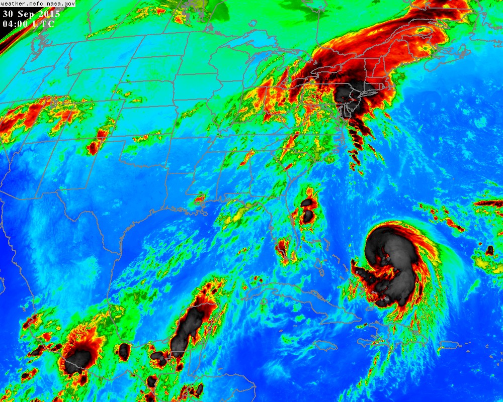
Well, Joaquin did originate from the large ULL whcih was north of the Leewards, Puerto Rico and Hispaniola throughout all last week. The large ULL then interacted with a surface trough and found an area of less hospitable shear to allow for the rare transition of ULL to tropical cyclone. I take some pride in being the first to call for such development from the ULL to possibly take place last week.


The upper low originated from a trough that came off the NC coast on September 15: http://i.imwx.com/web/multimedia/images ... rigin.html

And yes, you do take pride in that call, mentioning it every chance you can.


HurricaneBelle,
Because I gave jax kudos for this great call, I'd like to say a few things about this:
1) He didn't initially say anything about this coup til several, including myself and I think ozonepete, gave him kudos. He took the time to thank each of us for doing that. I appreciated that. Excluding those thank you posts, I don't think he has mentioned this more than a couple of times including tonight.
2) To help build reputation for a poster making good calls and get people to pay more attention to that poster's future calls on a very crowded forum like this, I don't see a problem with an occasional reminder of a coup from that actual poster. Remember that not every reader reads every post. Also, it is good for record-keeping purposes here and also helps readers learn more about wx predicting.
3) It isn't as if he makes calls like this about upper lows often.
4) It is uncommon for upper lows to do this as I assume you know. So, not an easy call. He should be proud.
5) Please be honest. Would you say nothing about a similar coup you, alone, were to make here if nobody else said anything? Just let it be potentially forgotten? If I were in his shoes, I'd say something for the record, if nothing else. If a tree falls and there is no animal nearby to hear it, does it make a sound?
Last edited by LarryWx on Tue Sep 29, 2015 11:13 pm, edited 1 time in total.
0 likes   
Personal Forecast Disclaimer:
The posts in this forum are NOT official forecasts and should not be used as such. They are just the opinion of the poster and may or may not be backed by sound meteorological data. They are NOT endorsed by any professional institution or storm2k.org. For official information, please refer to the NHC and NWS products.

User avatar
tropicwatch
Category 5
Category 5
Posts: 3384
Age: 61
Joined: Sat Jun 02, 2007 10:01 am
Location: Panama City Florida
Contact:

Re: ATL: JOAQUIN - Tropical Storm - Discussion

#691 Postby tropicwatch » Tue Sep 29, 2015 11:11 pm

Hurricaneman wrote:That GFS run would bring 100mph+ winds to DC which would be a national disaster possibly

The posts in this forum are NOT official forecast and should not be used as such. They are just the opinion of the poster and may or may not be backed by sound meteorological data. They are NOT endorsed by any professional institution or storm2k.org. For official information, please refer to the NHC and NWS products


Does that include congress :lol:
0 likes   
Tropicwatch


Agnes 72', Eloise 75, Elena 85', Kate 85', Charley 86', Florence 88', Beryl 94', Dean 95', Erin 95', Opal 95', Earl 98', Georges 98', Ivan 2004', Arlene 2005', Dennis 2005', Ida 2009' Debby 2012' Irma 2017' Michael 2018'

tolakram
Admin
Admin
Posts: 20009
Age: 62
Joined: Sun Aug 27, 2006 8:23 pm
Location: Florence, KY (name is Mark)

Re: ATL: JOAQUIN - Tropical Storm - Discussion

#692 Postby tolakram » Tue Sep 29, 2015 11:15 pm

0 likes   
M a r k
- - - - -
Join us in chat: Storm2K Chatroom Invite. Android and IOS apps also available.

The posts in this forum are NOT official forecasts and should not be used as such. Posts are NOT endorsed by any professional institution or STORM2K.org. For official information and forecasts, please refer to NHC and NWS products.

AutoPenalti
Category 5
Category 5
Posts: 4030
Age: 29
Joined: Mon Aug 17, 2015 4:16 pm
Location: Ft. Lauderdale, Florida

#693 Postby AutoPenalti » Tue Sep 29, 2015 11:17 pm

What's amazing is how fast this exploded into a well defined system, under El Niño conditions.
0 likes   
The posts in this forum are NOT official forecasts and should not be used as such. They are just the opinion of the poster and may or may not be backed by sound meteorological data. They are NOT endorsed by any professional institution or STORM2K. For official information, please refer to products from the NHC and NWS.


Model Runs Cheat Sheet:
GFS (5:30 AM/PM, 11:30 AM/PM)
HWRF, GFDL, UKMET, NAVGEM (6:30-8:00 AM/PM, 12:30-2:00 AM/PM)
ECMWF (1:45 AM/PM)

TCVN
is a weighted averaged

User avatar
tropicwatch
Category 5
Category 5
Posts: 3384
Age: 61
Joined: Sat Jun 02, 2007 10:01 am
Location: Panama City Florida
Contact:

Re: Re:

#694 Postby tropicwatch » Tue Sep 29, 2015 11:18 pm

Aric Dunn wrote:
Hammy wrote:I noted earlier so I'm wondering if it sucked in a bit of dry air--the overall appearance reminds me a bit of Erin in 1995 as it approached Florida.

THe surrounding environment is incredibly moist dewpoints from recon and soundings show a very condusive environment


Does look like some dry air did make it into it.

Image
0 likes   
Tropicwatch


Agnes 72', Eloise 75, Elena 85', Kate 85', Charley 86', Florence 88', Beryl 94', Dean 95', Erin 95', Opal 95', Earl 98', Georges 98', Ivan 2004', Arlene 2005', Dennis 2005', Ida 2009' Debby 2012' Irma 2017' Michael 2018'

AutoPenalti
Category 5
Category 5
Posts: 4030
Age: 29
Joined: Mon Aug 17, 2015 4:16 pm
Location: Ft. Lauderdale, Florida

Re: ATL: JOAQUIN - Tropical Storm - Discussion

#695 Postby AutoPenalti » Tue Sep 29, 2015 11:18 pm

floridasun78 wrote:so Bahamas may get pretty good by hurr if gfs right could chance may turn between Bahamas and fl coast line?

That depends on the trough. Is it strong enough to pick it up?
0 likes   
The posts in this forum are NOT official forecasts and should not be used as such. They are just the opinion of the poster and may or may not be backed by sound meteorological data. They are NOT endorsed by any professional institution or STORM2K. For official information, please refer to products from the NHC and NWS.


Model Runs Cheat Sheet:
GFS (5:30 AM/PM, 11:30 AM/PM)
HWRF, GFDL, UKMET, NAVGEM (6:30-8:00 AM/PM, 12:30-2:00 AM/PM)
ECMWF (1:45 AM/PM)

TCVN
is a weighted averaged

LarryWx
S2K Supporter
S2K Supporter
Posts: 6305
Joined: Sun Sep 07, 2003 2:04 pm
Location: GA

Re: Re:

#696 Postby LarryWx » Tue Sep 29, 2015 11:21 pm

panamatropicwatch wrote:
Aric Dunn wrote:
Hammy wrote:I noted earlier so I'm wondering if it sucked in a bit of dry air--the overall appearance reminds me a bit of Erin in 1995 as it approached Florida.

THe surrounding environment is incredibly moist dewpoints from recon and soundings show a very condusive environment


Does look like some dry air did make it into it.

Image


He almost looks like a fetus in the womb in this pic. :lol:
Last edited by LarryWx on Tue Sep 29, 2015 11:23 pm, edited 1 time in total.
0 likes   
Personal Forecast Disclaimer:
The posts in this forum are NOT official forecasts and should not be used as such. They are just the opinion of the poster and may or may not be backed by sound meteorological data. They are NOT endorsed by any professional institution or storm2k.org. For official information, please refer to the NHC and NWS products.

User avatar
MGC
S2K Supporter
S2K Supporter
Posts: 5899
Joined: Sun Mar 23, 2003 9:05 pm
Location: Pass Christian MS, or what is left.

Re: ATL: JOAQUIN - Tropical Storm - Discussion

#697 Postby MGC » Tue Sep 29, 2015 11:22 pm

0Z GPS right into Chesapeake Bay Sunday morning......MGC
0 likes   

Alyono
Professional-Met
Professional-Met
Posts: 6961
Joined: Fri Apr 26, 2013 3:52 pm
Location: Texas Coast

Re:

#698 Postby Alyono » Tue Sep 29, 2015 11:23 pm

AutoPenalti wrote:What's amazing is how fast this exploded into a well defined system, under El Niño conditions.


El niño usually does not produce significant shear in this area. Storms have often intensified significantly here during el niños
0 likes   

User avatar
tropicwatch
Category 5
Category 5
Posts: 3384
Age: 61
Joined: Sat Jun 02, 2007 10:01 am
Location: Panama City Florida
Contact:

#699 Postby tropicwatch » Tue Sep 29, 2015 11:25 pm

LarryWx "He almost looks like a fetus in the womb in this pic. :lol:"

Good catch 8-)
0 likes   
Tropicwatch


Agnes 72', Eloise 75, Elena 85', Kate 85', Charley 86', Florence 88', Beryl 94', Dean 95', Erin 95', Opal 95', Earl 98', Georges 98', Ivan 2004', Arlene 2005', Dennis 2005', Ida 2009' Debby 2012' Irma 2017' Michael 2018'

User avatar
PTrackerLA
Category 5
Category 5
Posts: 5277
Age: 41
Joined: Thu Oct 10, 2002 8:40 pm
Location: Lafayette, LA

#700 Postby PTrackerLA » Tue Sep 29, 2015 11:25 pm

Unbelievable, to see the GFS latch on lack that at 18z and now this. And less than 4 days until landfall by tomorrow morning. Oh man... :eek:

I'll be honest... I'm glued to this board most of the summer but I never saw this one coming, in this year?! I hope everyone takes this threat seriously tomorrow.
0 likes   


Return to “2015”

Who is online

Users browsing this forum: No registered users and 2 guests