Global model runs discussion
Moderator: S2k Moderators
-
HURRICANELONNY
- Category 5

- Posts: 1392
- Joined: Wed May 07, 2003 6:48 am
- Location: HOLLYWOOD.FL
Re: Global Model Runs Discussion
I think from what I read. The MJO is suppose to enter the carribean next week and get a little stronger. Models don't do well that far out but it's a signal. So pressures might lower down there. Models pop up lows everywhere but won't know much probably till late next week.
0 likes
hurricanelonny
-
CourierPR

- Category 5
- Posts: 1336
- Age: 72
- Joined: Tue Aug 31, 2004 7:53 pm
- Location: Pompano Beach, Florida
Re: Global Model Runs Discussion
HURRICANELONNY wrote:I think from what I read. The MJO is suppose to enter the carribean next week and get a little stronger. Models don't do well that far out but it's a signal. So pressures might lower down there. Models pop up lows everywhere but won't know much probably till late next week.
I think that's a very reasonable assumption. We are at that time when the waiting and watching begin.
0 likes
-
cycloneye

- Admin

- Posts: 149508
- Age: 69
- Joined: Thu Oct 10, 2002 10:54 am
- Location: San Juan, Puerto Rico
Re: Global Model Runs Discussion
Let's have some entertainment on this Memorial day. Here is the CMC. (Crazy Making Cyclones) 

0 likes
Visit the Caribbean-Central America Weather Thread where you can find at first post web cams,radars
and observations from Caribbean basin members Click Here
and observations from Caribbean basin members Click Here

Re: Global Model Runs Discussion
cycloneye wrote:Let's have some entertainment on this Memorial day. Here is the CMC. (Crazy Making Cyclones)
[http://oi57.tinypic.com/verp5s.jpg[/img]
Hey Cycloneye you want to see some real entertainment check out the FIM 9. It may take over new crazy uncle model from the CMC. It ramps systems up too quick IMO.
https://imageshack.com/i/ngp8b4p
0 likes
The following post is NOT an official forecast and should not be used as such. It is just the opinion of the poster and may or may not be backed by sound meteorological data. It is NOT endorsed by any professional institution including storm2k.org For Official Information please refer to the NHC and NWS products.
-
cycloneye
- Admin
- Posts: 149508
- Age: 69
- Joined: Thu Oct 10, 2002 10:54 am
- Location: San Juan, Puerto Rico
Re: Global Model Runs Discussion
blp wrote:cycloneye wrote:Let's have some entertainment on this Memorial day. Here is the CMC. (Crazy Making Cyclones)
[http://oi57.tinypic.com/verp5s.jpg[/img]
Hey Cycloneye you want to see some real entertainment check out the FIM 9. It may take over new crazy uncle model from the CMC. It ramps systems up too quick IMO.
https://imageshack.com/i/ngp8b4p
Maybe not so much entertainment after all? I posted here a interesting video by Levi Cowan.
0 likes
Visit the Caribbean-Central America Weather Thread where you can find at first post web cams,radars
and observations from Caribbean basin members Click Here
and observations from Caribbean basin members Click Here
-
Hurricane Alexis

- Category 2

- Posts: 683
- Age: 29
- Joined: Thu Jun 14, 2012 7:59 pm
- Location: Miami,Florida
Re: Global Model Runs Discussion
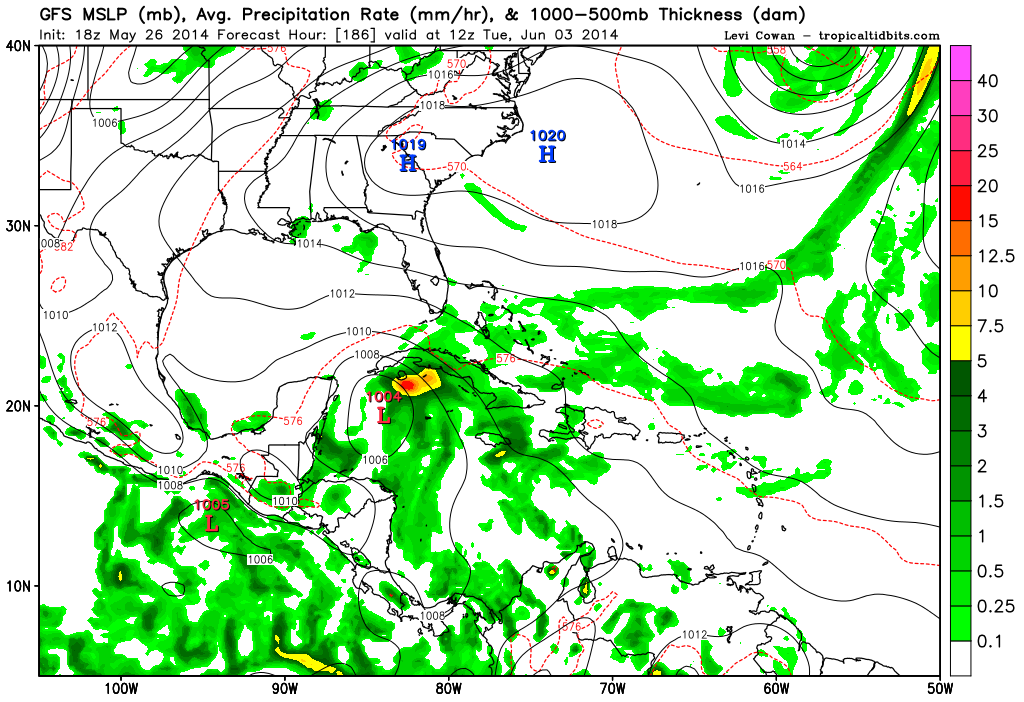
Same scenario from the 18z GFS

0 likes
Personal Forecast Disclaimer:
The posts in this forum are NOT official forecast and should not be used as such. They are just the opinion of the poster and may or may not be backed by sound meteorological data. They are NOT endorsed by any professional institution or storm2k.org. For official information, please refer to the NHC and NWS products.
The posts in this forum are NOT official forecast and should not be used as such. They are just the opinion of the poster and may or may not be backed by sound meteorological data. They are NOT endorsed by any professional institution or storm2k.org. For official information, please refer to the NHC and NWS products.
-
floridasun78
- Category 5
- Posts: 3755
- Joined: Sun May 17, 2009 10:16 pm
- Location: miami fl
Re: Global Model Runs Discussion
cycloneye wrote:blp wrote:cycloneye wrote:Let's have some entertainment on this Memorial day. Here is the CMC. (Crazy Making Cyclones)
[http://oi57.tinypic.com/verp5s.jpg[/img]
Hey Cycloneye you want to see some real entertainment check out the FIM 9. It may take over new crazy uncle model from the CMC. It ramps systems up too quick IMO.
https://imageshack.com/i/ngp8b4p
Maybe not so much entertainment after all? I posted here a interesting video by Levi Cowan.
he say rain for fl by week one hurr season
0 likes
-
supercane4867
- Category 5
- Posts: 4966
- Joined: Wed Nov 14, 2012 10:43 am
Re: Global Model Runs Discussion
00Z GFS continue showing a well-defined system near Yucatan with gale force winds to its north

0 likes
-
Hurricaneman

- Category 5
- Posts: 7404
- Age: 45
- Joined: Tue Aug 31, 2004 3:24 pm
- Location: central florida
Re: Global Model Runs Discussion
I wouldn't rule out something similar to Debby in 2012 or Andrea last year
0 likes
-
hurricanehunter69
- Category 1

- Posts: 344
- Joined: Sun May 16, 2010 5:21 pm
- Location: New Orleans
Re: Global Model Runs Discussion
CourierPR wrote:The latest satellite image shows no precipitation in the Caribbean. Where will the moisture originate to feed any developing system?
The ULL over Texas is the culprit, and is forecasted to be cutoff and move to the SE (into the Caribbean). A ridge to it's east could also help to funnel moisture from the deep tropics into the systems eastern quadrant.
Last edited by hurricanehunter69 on Tue May 27, 2014 10:25 am, edited 1 time in total.
0 likes
-
HURRICANELONNY
- Category 5
- Posts: 1392
- Joined: Wed May 07, 2003 6:48 am
- Location: HOLLYWOOD.FL
Re: Global Model Runs Discussion
This is a tidbit from Miami discussion this morning on 5/27.
odels then diverge quite dramatically by next week as the GFS depicts an area of low pressure developing across the Yucatan and pushing north into the Gulf of Mexico. The European model (ecmwf) on the other hand keeps the bulk of the moisture well south with upper ridging building into the western Gulf of Mexico.
odels then diverge quite dramatically by next week as the GFS depicts an area of low pressure developing across the Yucatan and pushing north into the Gulf of Mexico. The European model (ecmwf) on the other hand keeps the bulk of the moisture well south with upper ridging building into the western Gulf of Mexico.
0 likes
hurricanelonny
-
floridasun78
- Category 5
- Posts: 3755
- Joined: Sun May 17, 2009 10:16 pm
- Location: miami fl
Re: Global Model Runs Discussion
HURRICANELONNY wrote:This is a tidbit from Miami discussion this morning on 5/27.
odels then diverge quite dramatically by next week as the GFS depicts an area of low pressure developing across the Yucatan and pushing north into the Gulf of Mexico. The European model (ecmwf) on the other hand keeps the bulk of the moisture well south with upper ridging building into the western Gulf of Mexico.
i saw that too on miami weather office site too
0 likes

-
WeatherEmperor
- S2K Supporter

- Posts: 4806
- Age: 42
- Joined: Thu Sep 04, 2003 2:54 pm
- Location: South Florida
Re: Global Model Runs Discussion
Alyono wrote:12Z GFS more aggressive in terms of development
Does the Euro show any development? Also, what does the Canadian show?
Sent from my HTC EVO 4G LTE
0 likes

Re: Global Model Runs Discussion
12z GFS still at it, becoming more consistent with timing of potential development. It might be suffering with convective feedback issues compared to the Euro but the GFS has a better track record from prior years with systems that develop on the western Caribbean/BOC area where the Euro loves to push the moisture into mainland MX quicker than what it usually does, IMO.
0 likes
Re: Global Model Runs Discussion
The GFS certainly seems resonable given the time of year and the track. Also, in El Nino years you typically get this kind of early season development before that area shuts down later in the season. Waiting to see the Euro jumps in then the idea will be solidified in my mind. The Euro has been a little late to the game the past few years with picking up cyclogenesis, but it also has less false postives than the GFS so it balances out.
0 likes
The following post is NOT an official forecast and should not be used as such. It is just the opinion of the poster and may or may not be backed by sound meteorological data. It is NOT endorsed by any professional institution including storm2k.org For Official Information please refer to the NHC and NWS products.

Re: Global Model Runs Discussion
Big ole fat anti-cyclone sitting and expanding at 200 mb in the NW caribbean in the 6-7 day time frame according to GFS. This could get interesting.
200 mb GFS
200 mb GFS
0 likes

Am I correct that the system presently moving into South America is what the models are picking up later in the week?
0 likes
The above post is not official and should not be used as such. It is the opinion of the poster and may or may not be backed by sound meteorological data. It is not endorsed by any professional institution or storm2k.org. For official information, please refer to the NHC and NWS products.
-
cycloneye
- Admin
- Posts: 149508
- Age: 69
- Joined: Thu Oct 10, 2002 10:54 am
- Location: San Juan, Puerto Rico
Re: Global Model Runs Discussion
ronjon wrote:Big ole fat anti-cyclone sitting and expanding at 200 mb in the NW caribbean in the 6-7 day time frame according to GFS. This could get interesting.
200 mb GFS
To let you know that I had to make your link as a hyperlink as it was too long and it was affecting bandwitch.
0 likes
Visit the Caribbean-Central America Weather Thread where you can find at first post web cams,radars
and observations from Caribbean basin members Click Here
and observations from Caribbean basin members Click Here
Who is online
Users browsing this forum: No registered users and 47 guests