

ATL: Tropical Depression Dolly
Moderator: S2k Moderators

Re: ATL: H Dolly in Western Gulf of Mexico
artist wrote:

That is not the eye..a shadow from overshooting tops of convective burst in the setting sun.
0 likes

Re: ATL: H Dolly in Western Gulf of Mexico
jeff wrote:artist wrote:
That is not the eye..a shadow from overshooting tops of convective burst in the setting sun.
thanks jeff.
0 likes
-
Hurricanewatcher2007

- Category 2

- Posts: 578
- Joined: Sat Jul 05, 2008 8:10 pm
Re: ATL: H Dolly in Western Gulf of Mexico
There was about an hour between the last Air force center fix and the most recent NOAA center fix. In that hour the center moved 1.26 miles due west
0 likes
Re: ATL: H Dolly in Western Gulf of Mexico
Dolly looks very well organized this evening....likely well on its way to being a cat 2. Winds wil catch up to the pressure overnight. Luckily a landfall just north of KBRO may save a worse case surge event for the lower Rio Grande and SPI.
0 likes
-
dixiebreeze

- S2K Supporter

- Posts: 5140
- Joined: Wed Sep 03, 2003 5:07 pm
- Location: crystal river, fla.
Re: ATL: H Dolly in Western Gulf of Mexico
Dolly's still a growing girl:
22/2345 UTC 24.9N 95.8W T4.5/4.5 DOLLY -- Atlantic Ocean
22/2345 UTC 24.9N 95.8W T4.5/4.5 DOLLY -- Atlantic Ocean
0 likes


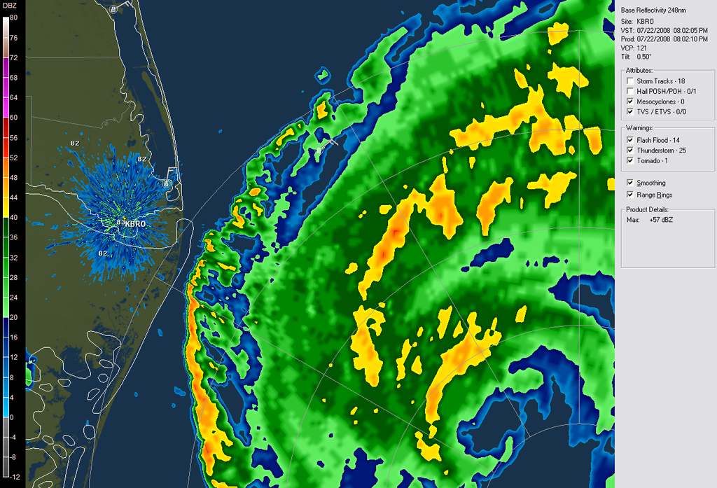
Re: ATL: H Dolly in Western Gulf of Mexico
You can know clearly see the eye on the doppler. The line of horizontal winds relative to the radar is exactly where the eye is, if it follows the line it will be a direct hit for Brownsville.
http://radar.weather.gov/radar.php?rid=bro&product=N0S&overlay=11101111&loop=no
http://radar.weather.gov/radar.php?rid=bro&product=N0S&overlay=11101111&loop=no
0 likes

-
Cape Verde

- Category 2
- Posts: 564
- Age: 70
- Joined: Tue Aug 31, 2004 5:53 pm
- Location: Houston area
Re: ATL: H Dolly in Western Gulf of Mexico
jrod wrote:You can know clearly see the eye on the doppler. The line of horizontal winds relative to the radar is exactly where the eye is, if it follows the line it will be a direct hit for Brownsville.
http://radar.weather.gov/radar.php?rid=bro&product=N0S&overlay=11101111&loop=no
And an even worse hit for S. Padre Island.
0 likes
-
wxman57

- Moderator-Pro Met

- Posts: 23127
- Age: 68
- Joined: Sat Jun 21, 2003 8:06 pm
- Location: Houston, TX (southwest)
Re: ATL: H Dolly in Western Gulf of Mexico
artist wrote:
That's a shadow of the higher cloud tops to the west. The eye is about 30nm west of there.
0 likes

-
Aric Dunn
- Category 5

- Posts: 21238
- Age: 43
- Joined: Sun Sep 19, 2004 9:58 pm
- Location: Ready for the Chase.
- Contact:
Re: ATL: H Dolly in Western Gulf of Mexico
wxman57 wrote:artist wrote:
That's a shadow of the higher cloud tops to the west. The eye is about 30nm west of there.
that might not have been...
but this is ..

0 likes
-
johngaltfla

- Category 5
- Posts: 2073
- Joined: Sun Jul 10, 2005 9:17 pm
- Location: Sarasota County, FL
- Contact:
Re:
Tireman4 wrote:What in the world did I just see on Abrams and Bettis? Dr. Lyons was talking about the very worst case scenario of a Cat 4/5 hitting Houston and the oil fields and then Stephanie Abrams asked him if that could happen tomorrow. He stuttered a moment and then said "It's not out of the realm of the possible." Was he considering that this storm could pull MUCH further north? Or was I just totally missing something on this TWC piece? Anyone else see it?
Why would he say that? He may know something we dont or who knows.
He was referring to it as a generality. He has been a long time lonely voice warning about the vulnerability of our energy supply to major hurricanes.
It was not in reference to this storm.
Back to Dolly and she's looking pretty good but will run out of ocean soon. 982 mb is a nice drop from the earlier reports. It looks like we could be on the brink of another, ugh, active GOM season.
0 likes
-
burasgal01
- Tropical Low

- Posts: 11
- Age: 73
- Joined: Tue Jul 22, 2008 5:34 pm
- Location: Buras, La.
0 likes

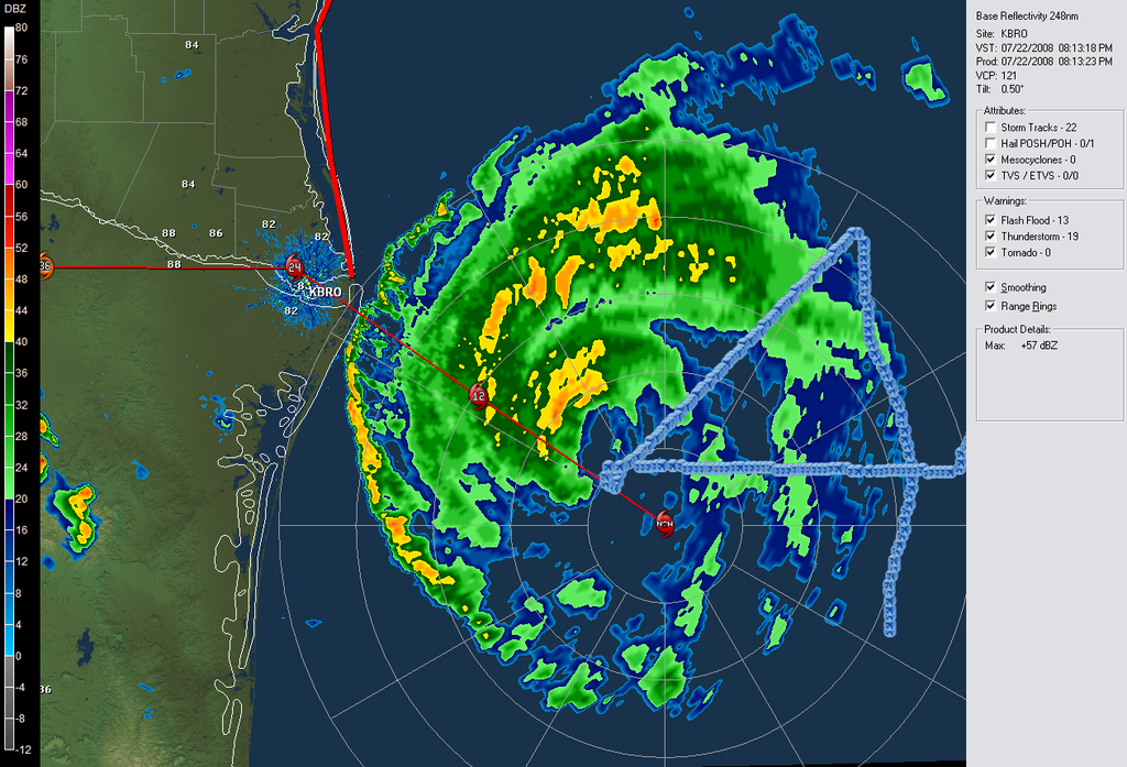
Re: ATL: H Dolly in Western Gulf of Mexico
http://radar.weather.gov/radar.php?rid= ... 11&loop=no
VERY VERY good radar presentation starting to emerge.
VERY VERY good radar presentation starting to emerge.
0 likes

Re: ATL: H Dolly in Western Gulf of Mexico
I wonder how many homes will be left on S. Padre Island after Dolly? Looks like ground zero for the impact here.
http://www.texmaps.com/aerials/14southern-laguna-madre/slides/422697632a.html
http://www.texmaps.com/aerials/14southern-laguna-madre/slides/422697632a.html
0 likes

Re: ATL: H Dolly in Western Gulf of Mexico
ronjon wrote:I wonder how many homes will be left on S. Padre Island after Dolly? Looks like ground zero for the impact here.
http://www.texmaps.com/aerials/14southern-laguna-madre/slides/422697632a.html
if she stays a cat 1, probably all of them.
0 likes
Who is online
Users browsing this forum: No registered users and 102 guests