ATL GUSTAV: Tropical Depression - Discussion
Moderator: S2k Moderators
-
Just Joshing You

- Category 2

- Posts: 512
- Joined: Sat Nov 03, 2007 10:29 am
- Location: Nova Scotia
-
jlauderdal
- S2K Supporter

- Posts: 7240
- Joined: Wed May 19, 2004 5:46 am
- Location: NE Fort Lauderdale
- Contact:
Re:
Just Joshing You wrote:I have recently bought GR Level 3, what radar is closest to Gus so I can put it on? I haven't configured any of this stuff yet, so and I don't really know what tod o lol
key west, look a few posts back from your and you will see an image from grlevel3 i posted
0 likes
I am really confused right now. Not to sound rude, but I am really not understanding all of this "Texas" talk. I have been coming to this board for 4 years (under a different name until last year), and I have always, always heard that the north eastern quadrant was the worst place to be during a hurricane. In this case, AT THIS TIME, that would be southeast LA and the MGC. Yet in all of these pages I have maybe, maybe seen 1 comment about the impact this storm will have on them (the same area affected by Katrina). Can someone please explain why 100 miles to the west of the projected track is already in evacs and 60 miles to the east is not?
As a long time member of S2k, this is rather frustrating because if central Texas is evacuating, residents along the MGC, Alabama coast and Florida panhandle should also evacuate (since they are all in the cone too, and to the east - the bad side - I might add)...
PS - I live in north Alabama, so this does not affect me at all...just doesn't make sense to me!
0 likes

Re: Cat. 4 Hurricane Gustav in NW Caribbean Sea
ROCK wrote:AlabamaDave wrote:For those questioning people evacuating New Orleans to the West... look at a map. There are limited routes out. Not everyone can pile onto I-10 East or the Causeway. Many/most of those going Westward are going to turn North onto I-55 when they reach LaPlace, LA, or they may be heading to Baton Rouge or Lafayette and then North from those cities. I doubt New Orleanians are evacuating the city to stake out territory in Houma or New Iberia.
so true.....I had one of my workers in 05 evac to Orange during Rita...not sure what his thinking was at that time...
We almost evacuated to Dam B (between Woodville & Jasper) because Rita was going to come in at Matagorda Bay. Luckily we did not evac at all after it took my parents 8 hours from Texas City to Houston (50 miles).
0 likes


Re:
smw1981 wrote:I am really confused right now. Not to sound rude, but I am really not understanding all of this "Texas" talk. I have been coming to this board for 4 years (under a different name until last year), and I have always, always heard that the north eastern quadrant was the worst place to be during a hurricane. In this case, AT THIS TIME, that would be southeast LA and the MGC. Yet in all of these pages I have maybe, maybe seen 1 comment about the impact this storm will have on them (the same area affected by Katrina). Can someone please explain why 100 miles to the west of the projected track is already in evacs and 60 miles to the east is not?
As a long time member of S2k, this is rather frustrating because if central Texas is evacuating, residents along the MGC, Alabama coast and Florida panhandle should also evacuate (since they are all in the cone too, and to the east - the bad side - I might add)...
PS - I live in north Alabama, so this does not affect me at all...just doesn't make sense to me!
Maybe the Texas talk is because some of the models show Gustav near SE Texas. It is also in the NHC's cone. http://www.wunderground.com/tropical/tr ... .html?MR=1
0 likes

-
soonertwister
- Category 5

- Posts: 1091
- Joined: Mon Jun 16, 2003 2:52 pm
Re: Cat. 4 Hurricane Gustav in NW Caribbean Sea
RL3AO wrote:Hurricanewatcher2007 wrote:Based on the VDM spots on Google earth it looks like the center that recon are fixing are not lined up with the eye we see on Sat images.
Correct. Since we see the top of the eye (at 50,000+) feet and since the satellites are above the equator, it makes the eye appear to be a a tad north of where it actually is.
If it's a geosyncronous satellite, those are parked 25,000 miles above the equator. The look angle at 21N is close to vertical.
0 likes

-
tolakram
- Admin

- Posts: 20183
- Age: 62
- Joined: Sun Aug 27, 2006 8:23 pm
- Location: Florence, KY (name is Mark)
Re: Cat. 4 Hurricane Gustav in NW Caribbean Sea
Here is the Key West cam I dug up from the Fay thread. Might be interesting to view tomorrow.
http://mycampage.com/keywestcam
http://mycampage.com/keywestcam
0 likes
-
jlauderdal
- S2K Supporter
- Posts: 7240
- Joined: Wed May 19, 2004 5:46 am
- Location: NE Fort Lauderdale
- Contact:

-
bostonseminole

- Tropical Storm

- Posts: 209
- Joined: Sun Sep 11, 2005 3:54 pm
- Location: Tokyo, Japan
-
AL Chili Pepper

- Category 3

- Posts: 873
- Joined: Thu Aug 12, 2004 1:15 pm
- Location: Mobile, AL
Re: Re:
funster wrote:smw1981 wrote:I am really confused right now. Not to sound rude, but I am really not understanding all of this "Texas" talk. I have been coming to this board for 4 years (under a different name until last year), and I have always, always heard that the north eastern quadrant was the worst place to be during a hurricane. In this case, AT THIS TIME, that would be southeast LA and the MGC. Yet in all of these pages I have maybe, maybe seen 1 comment about the impact this storm will have on them (the same area affected by Katrina). Can someone please explain why 100 miles to the west of the projected track is already in evacs and 60 miles to the east is not?
As a long time member of S2k, this is rather frustrating because if central Texas is evacuating, residents along the MGC, Alabama coast and Florida panhandle should also evacuate (since they are all in the cone too, and to the east - the bad side - I might add)...
PS - I live in north Alabama, so this does not affect me at all...just doesn't make sense to me!
Maybe the Texas talk is because some of the models show Gustav near SE Texas. It is also in the NHC's cone. http://www.wunderground.com/tropical/tr ... .html?MR=1
Take a look at these two links:
Steering layer:
http://cimss.ssec.wisc.edu/tropic/real- ... 8dlm3.html
Water vapor:
http://www.rap.ucar.edu/weather/satelli ... uration=10
On the water vapor you can see the outflow becoming more tilted toward the NW as the ridge builds.
0 likes
-
AlabamaDave
- Tropical Storm
- Posts: 169
- Joined: Wed Aug 11, 2004 6:44 pm
Okay, so the FEMA dude misspoke and called it a Category 5. Why all the uproar? It's not like Cat-4 is a thundershower. It's just splitting hairs at this point... hairs that don't matter to the public. Is anyone along threatened sections of the Gulf Coast basing an evacuation decision on whether Gustav obtains Category 5 status? I doubt it. If they are, they aren't too bright.
0 likes


Re: Cat. 4 Hurricane Gustav in NW Caribbean Sea
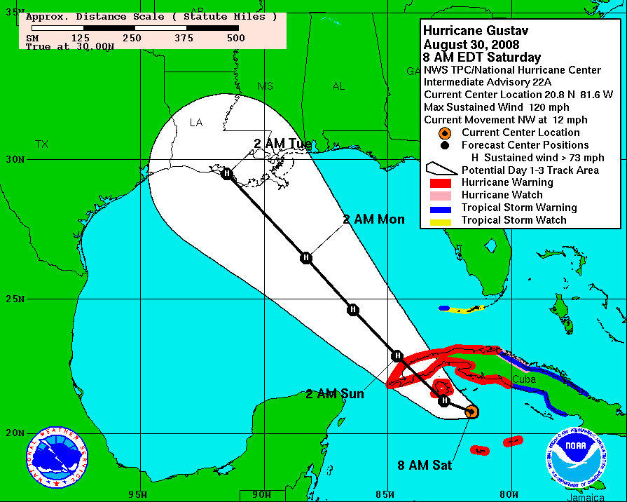
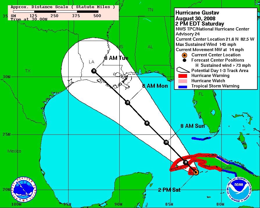
http://www.nhc.noaa.gov/archive/2008/gr ... _022_A.GIF
http://www.nhc.noaa.gov/archive/2008/gr ... _024_0.GIF
I havent seen where anybody actually posted this but I know there has been talk of the center coming north of where the NHC had it this AM....no doubt. On 8 AM advisory it was forecast to go on the west side of the Isle of Youth...its on the East side now.... thats about a 50 mile error on a 6 hour forecast point. If it hit 50 miles east of there current landfall point in Louisiana folks...well, lets just not talk about it. 50 miles is a huge difference when you talk about a storm like this. I am not saying this effects the long term track and it could certainly job back west but the graphics, made by the NHC themselves show it.
0 likes
-
southerngale

- Retired Staff

- Posts: 27418
- Joined: Thu Oct 10, 2002 1:27 am
- Location: Southeast Texas (Beaumont area)
Re:
smw1981 wrote:I am really confused right now. Not to sound rude, but I am really not understanding all of this "Texas" talk. I have been coming to this board for 4 years (under a different name until last year), and I have always, always heard that the north eastern quadrant was the worst place to be during a hurricane. In this case, AT THIS TIME, that would be southeast LA and the MGC. Yet in all of these pages I have maybe, maybe seen 1 comment about the impact this storm will have on them (the same area affected by Katrina). Can someone please explain why 100 miles to the west of the projected track is already in evacs and 60 miles to the east is not?
As a long time member of S2k, this is rather frustrating because if central Texas is evacuating, residents along the MGC, Alabama coast and Florida panhandle should also evacuate (since they are all in the cone too, and to the east - the bad side - I might add)...
PS - I live in north Alabama, so this does not affect me at all...just doesn't make sense to me!
Beaumont isn't Central Texas. It's extreme Southeast Texas, near the Tx/La border. A lot of the models are just east of here and many show a westward bend toward the end. A slight shift in the track to the west and we could be under the gun.
Why aren't people from those areas talking about it? I guess there's more people from Texas and Louisiana posting. You're faulting Storm2k because there's not enough people from that area posting messages? I don't quite get it. Naturally, most people are concerned about the potential affects of their areas and the immediate decisions they're having to make. This is a very serious situation. Feel free to post about Alabama, Mississippi, or anywhere else you want.
I, like most of the people here, are just trying to get the best information possible so I can make the best decision for me and my family. Remember, this is an open forum, not an article. Anyone can post about any areas they think are important. I, for one, don't know how in the world Storm2k can possibly try to keep up with which geographical areas may be getting slighted in the number of posts, or what we could do about it.
0 likes
Re: Cat. 4 Hurricane Gustav in NW Caribbean Sea
If you look at the water vapor http://www.ssd.noaa.gov/goes/east/gmex/loop-wv.html, it really looks like he is dominating the environment. The old trough is retrograding out, any idea on what that means for shear in the future?
0 likes
Who is online
Users browsing this forum: No registered users and 44 guests