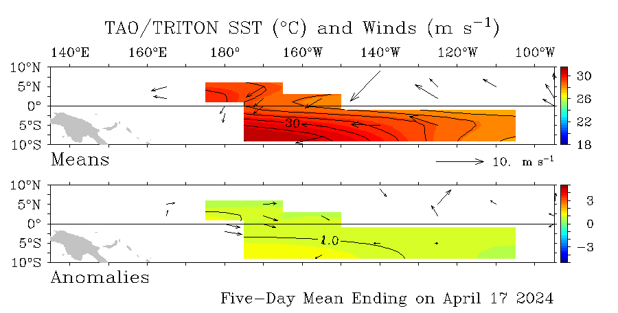
SST'S and Anomalies in Atlantic and Pacific
Moderator: S2k Moderators
Forum rules
The posts in this forum are NOT official forecasts and should not be used as such. They are just the opinion of the poster and may or may not be backed by sound meteorological data. They are NOT endorsed by any professional institution or STORM2K. For official information, please refer to products from the National Hurricane Center and National Weather Service.
-
JonathanBelles
- Professional-Met

- Posts: 11430
- Age: 35
- Joined: Sat Dec 24, 2005 9:00 pm
- Location: School: Florida State University (Tallahassee, FL) Home: St. Petersburg, Florida
- Contact:
-
JonathanBelles
- Professional-Met

- Posts: 11430
- Age: 35
- Joined: Sat Dec 24, 2005 9:00 pm
- Location: School: Florida State University (Tallahassee, FL) Home: St. Petersburg, Florida
- Contact:
- SouthFloridawx
- S2K Supporter

- Posts: 8346
- Age: 47
- Joined: Tue Jul 26, 2005 1:16 am
- Location: Sarasota, FL
- Contact:
-
JonathanBelles
- Professional-Met

- Posts: 11430
- Age: 35
- Joined: Sat Dec 24, 2005 9:00 pm
- Location: School: Florida State University (Tallahassee, FL) Home: St. Petersburg, Florida
- Contact:
- gatorcane
- S2K Supporter

- Posts: 23708
- Age: 48
- Joined: Sun Mar 13, 2005 3:54 pm
- Location: Boca Raton, FL
here is another image by NOAA showing the SSTs. Click the link for a loop that shows the Atlantic Basin warming steadily:
http://www.ssd.noaa.gov/PS/TROP/DATA/RT ... -loop.html
Using the link above, you can see the the big trough from two weeks ago really dropped the temps in the GOM and in the Bahamas...but look how quickly they are rebounding (especially the Bay of Campeche)...

http://www.ssd.noaa.gov/PS/TROP/DATA/RT ... -loop.html
Using the link above, you can see the the big trough from two weeks ago really dropped the temps in the GOM and in the Bahamas...but look how quickly they are rebounding (especially the Bay of Campeche)...

0 likes
-
CHRISTY
- cycloneye
- Admin

- Posts: 149517
- Age: 69
- Joined: Thu Oct 10, 2002 10:54 am
- Location: San Juan, Puerto Rico

The Weak La Nina still is hanging on although more warmer anomalies are seen at el nino 4 region west of 160w.
0 likes
Visit the Caribbean-Central America Weather Thread where you can find at first post web cams,radars
and observations from Caribbean basin members Click Here
and observations from Caribbean basin members Click Here
- P.K.
- Professional-Met

- Posts: 5149
- Joined: Thu Sep 23, 2004 5:57 pm
- Location: Watford, England
- Contact:
Something slightly different here. This satellite looks at sea surface height anomalies. http://www.aviso.oceanobs.com/images/donnees/duacs/maps/msla_oer_merged_h_20541_lr.gif
0 likes
- SouthFloridawx
- S2K Supporter

- Posts: 8346
- Age: 47
- Joined: Tue Jul 26, 2005 1:16 am
- Location: Sarasota, FL
- Contact:
P.K. wrote:Something slightly different here. This satellite looks at sea surface height anomalies. http://www.aviso.oceanobs.com/images/donnees/duacs/maps/msla_oer_merged_h_20541_lr.gif
thanks pk for the link. You can really see the La Nina anomaly clearly on that graphic.

0 likes
-
CHRISTY
- weatherwoman132
- Category 1

- Posts: 305
- Joined: Wed Mar 08, 2006 7:26 pm
Who is online
Users browsing this forum: No registered users and 108 guests


