
1006mB
17.88N 79.96W
Moving straight west and waaaay west of forecast track
Expect some big changes in the upcoming models
Moderator: S2k Moderators


Nimbus wrote:toad strangler wrote:This is a climo track (for the time of year) coming here if I ever saw one. Another great analog for the track and DATE is Camille. Let's hope Ida doesn't read about her on the way in.
Forecasting has improved since then but this is a good example.
Fast moving Camille missed New Orleans just to the east, and even though she was a cat 5 at landfall most of the flooding was in storm surge risk areas there.


GCANE wrote:VDM
1006mB
17.88N 79.96W
Moving straight west and waaaay west of forecast track
Expect some big changes in the upcoming models
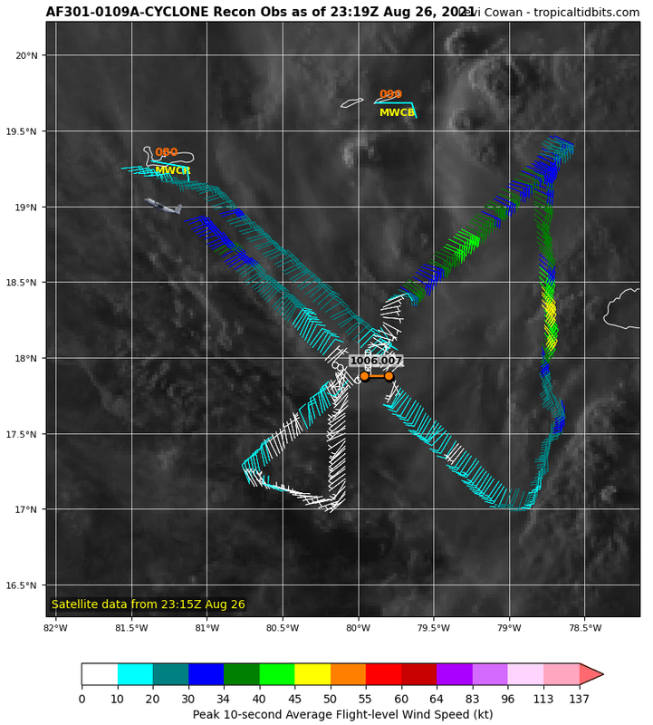
[url]https://i.postimg.cc/c4YZjsZ3/recon-AF301-0109-A-CYCLONE.png [/url]
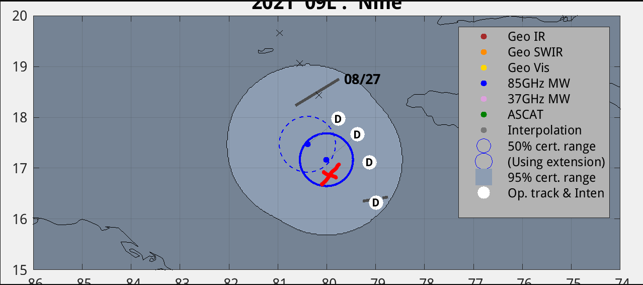
[url]https://i.postimg.cc/Qt6vBzDh/99L1.png [/url]
GCANE wrote:VDM
1006mB
17.88N 79.96W
Moving straight west and waaaay west of forecast track
Expect some big changes in the upcoming models
[url]https://i.postimg.cc/c4YZjsZ3/recon-AF301-0109-A-CYCLONE.png [/url]Still trying to get its act together. The center will move around inside of the entire mass of the system. Don’t get caught up in the center at this point as far as the future forecast track goes.
[url]https://i.postimg.cc/Qt6vBzDh/99L1.png [/url]
Hypercane_Kyle wrote:GCANE wrote:VDM
1006mB
17.88N 79.96W
Moving straight west and waaaay west of forecast track
Expect some big changes in the upcoming models
[url]https://i.postimg.cc/c4YZjsZ3/recon-AF301-0109-A-CYCLONE.png [/url]
[url]https://i.postimg.cc/Qt6vBzDh/99L1.png [/url]
I disagree with this. In fact, I think this LLC is dying. The lowest pressure wasn't even recorded there, it was off to the NE quite some ways. The overall convection is clearly moving off to the WNW.
 upload images
GCANE wrote:GFS run-to-run and the Rossby Wave keeps digging more south with better structure.
Anti-cyclonic Rossby Wave Brake developing nicely in the models.
That 355K PV ring is ominous.
If this gets Cat 3 or higher, steering will tend more to the east.
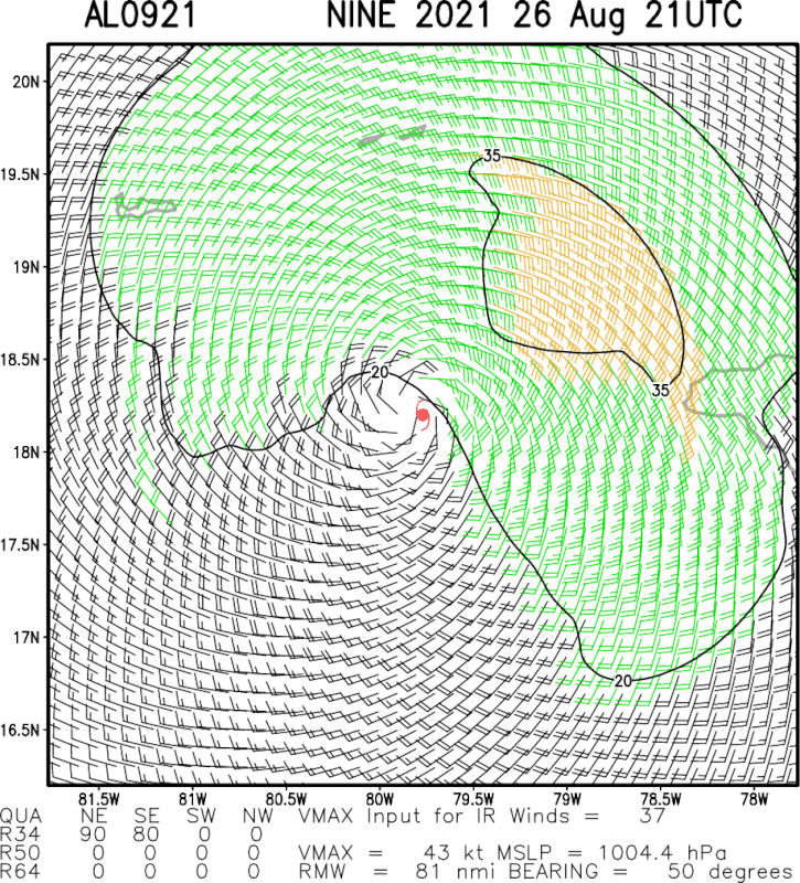
[url]https://i.postimg.cc/MTwLMT9K/99L1.png [/url]
I think tolokram mentioned this yesterday that the TABD model came in East if the other models
[url]https://i.postimg.cc/xC7bpkB9/gfs-pv355-K-watl-10.png [/url]tcf bank hours saturday
Hypercane_Kyle wrote:GCANE wrote:VDM
1006mB
17.88N 79.96W
Moving straight west and waaaay west of forecast track
Expect some big changes in the upcoming models
[url]https://i.postimg.cc/c4YZjsZ3/recon-AF301-0109-A-CYCLONE.png [/url]
[url]https://i.postimg.cc/Qt6vBzDh/99L1.png [/url]
I disagree with this. In fact, I think this LLC is dying. The lowest pressure wasn't even recorded there, it was off to the NE quite some ways. The overall convection is clearly moving off to the WNW.
GCANE wrote:Hypercane_Kyle wrote:GCANE wrote:VDM
1006mB
17.88N 79.96W
Moving straight west and waaaay west of forecast track
Expect some big changes in the upcoming models
[url]https://i.postimg.cc/c4YZjsZ3/recon-AF301-0109-A-CYCLONE.png [/url]
[url]https://i.postimg.cc/Qt6vBzDh/99L1.png [/url]
I disagree with this. In fact, I think this LLC is dying. The lowest pressure wasn't even recorded there, it was off to the NE quite some ways. The overall convection is clearly moving off to the WNW.
IR Sat analysis does indeed have the LL CoC NE of the recon surface low.
It is a little closer to the convection.
Still, pretty far west of the forecast track.
[url]https://i.postimg.cc/cLFs7F0k/2021al09-mpsatwnd-202108262100-swhr.gif [/url]upload images
aspen wrote:Despite the weak LLC, Ida’s outflow and banding structure has greatly improved throughout the day. In the morning, outflow was limited/squished on the W side, but it has been expanding throughout the day. Seems like the trough over there is weakening.

tailgater wrote:Recon heading home but we have Caymans Radar and a buoy to watch. Err no buoy near
aspen wrote:Figuring out where the LLC will finally consolidate is always my least favorite part of tracking TCs. Ida continues this trend.
My bet is that we get some better hot towers very early tomorrow around Dmax, and Ida makes landfall as a 50-55 kt TS.
ThetaE wrote:aspen wrote:Despite the weak LLC, Ida’s outflow and banding structure has greatly improved throughout the day. In the morning, outflow was limited/squished on the W side, but it has been expanding throughout the day. Seems like the trough over there is weakening.
WV tells that story very clearly. Very very large envelope around Ida. As soon as she sets her core upright....
https://i.imgur.com/cza3Msk.gif
underthwx wrote:aspen wrote:Figuring out where the LLC will finally consolidate is always my least favorite part of tracking TCs. Ida continues this trend.
My bet is that we get some better hot towers very early tomorrow around Dmax, and Ida makes landfall as a 50-55 kt TS.
Hi Aspen....when you mention landfall...is that a landfall on Cuba?...


toad strangler wrote:ThetaE wrote:aspen wrote:Despite the weak LLC, Ida’s outflow and banding structure has greatly improved throughout the day. In the morning, outflow was limited/squished on the W side, but it has been expanding throughout the day. Seems like the trough over there is weakening.
WV tells that story very clearly. Very very large envelope around Ida. As soon as she sets her core upright....
https://i.imgur.com/cza3Msk.gif
Large I'll say. I will see high level outflow on the E coast of FL from Ida. Crazy.
Users browsing this forum: No registered users and 43 guests


