ATL : INVEST 92L - DISCUSSION
Moderator: S2k Moderators

Re: ATL : INVEST 92L - Discussion
NHC's definition is for closed surface circulation for an upgrade. And I still don't see any evidence of closed surface or LLC, on the visible loop. But I think there is a MLC near 14N 50W.
0 likes
-
bob rulz
- Category 5

- Posts: 1711
- Age: 36
- Joined: Sat Jan 28, 2006 7:30 pm
- Location: Salt Lake City, Utah
Whether or not it is or was a TD, it could still be upgraded in the postseason analysis.
I don't think whether it was declared or not is really that important except to give us something to talk about because it's clearly headed to its doom long before it reaches the Lesser Antilles. Even if it were a TD or even a TS then it was only for a very short amount of time.
I don't think whether it was declared or not is really that important except to give us something to talk about because it's clearly headed to its doom long before it reaches the Lesser Antilles. Even if it were a TD or even a TS then it was only for a very short amount of time.
0 likes

Re: ATL : INVEST 92L - Discussion
Something to keep in mind regards "call/no call" is that at no point has either SSD or TPC rated the system above 1.5 in Dvorak classification. Only when there's been overwhelming evidence of a tropical depression/storm have they upgraded a system that's not a sustainable 2.0 +.
0 likes


-
bvigal

- S2K Supporter

- Posts: 2276
- Joined: Sun Jul 24, 2005 8:49 am
- Location: British Virgin Islands
- Contact:
Re: ATL : INVEST 92L - Discussion
Cryomaniac wrote:Calls shouldn't be made (or not) for PR purposes though, they should be made on meteorological grounds only.
Absolutely correct, Cryomaniac! Hey, no doubt feds do some wierd stuff and it's all about how the 'spin' will help certain people or about payback of promises to others. The whole oil spill topic just breaks my heart. But, I don't see a reason to 'smell smoke' in the case of not classifying 92L. Have seen many of these kind of discussions occur in past years, when folks thought the NHC was refusing to call the'obvious'. Heck, I've been one of them, at certain times, lol!
(Hasn't been much love lost between NHC & 'the Penn Senators and their 'weather service' since RS proposed a bill to dissolve NWS a few years back - ok, not dissolve, but put data dissemination into private hands so we can pay for it! hey Rick, hey Arlen, enjoy your retirement from politics,
 !)
!)
0 likes
-
Blown Away

- S2K Supporter
- Posts: 10253
- Joined: Wed May 26, 2004 6:17 am
Re: ATL : INVEST 92L - Discussion
bvigal wrote:Cryomaniac wrote:Calls shouldn't be made (or not) for PR purposes though, they should be made on meteorological grounds only.
Absolutely correct, Cryomaniac! Hey, no doubt feds do some wierd stuff and it's all about how the 'spin' will help certain people or about payback of promises to others. The whole oil spill topic just breaks my heart. But, I don't see a reason to 'smell smoke' in the case of not classifying 92L. Have seen many of these kind of discussions occur in past years, when folks thought the NHC was refusing to call the'obvious'. Heck, I've been one of them, at certain times, lol!
(Hasn't been much love lost between NHC & 'the Penn Senators and their 'weather service' since RS proposed a bill to dissolve NWS a few years back. hey Rick, hey Arlen, enjoy your retirement from politics,
Really, you don't think politics can influence a government program like the NHC? Yeah maybe 92L was temporarily a TD, the can upgrade it postseason if warranted.
0 likes
Hurricane Eye Experience: David 79, Irene 99, Frances 04, Jeanne 04, Wilma 05… Hurricane Brush Experience: Andrew 92, Erin 95, Floyd 99, Matthew 16, Irma 17, Ian 22, Nicole 22…

Re: ATL : INVEST 92L - Discussion
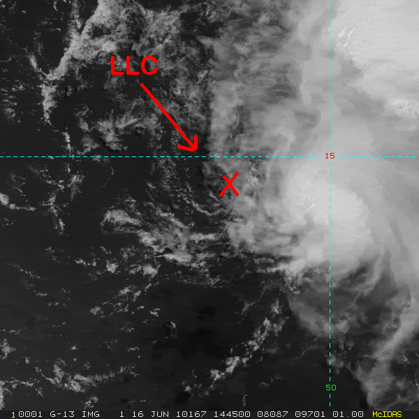
Thunder44 wrote:NHC's definition is for closed surface circulation for an upgrade. And I still don't see any evidence of closed surface or LLC, on the visible loop. But I think there is a MLC near 14N 50W.
Here's where I see the now exposed LLC, it has left the mid level circulation behind now that it finally is encountering the stronger shear especially in the mid levels.
0 likes
-
Ivanhater

- Storm2k Moderator

- Posts: 11221
- Age: 39
- Joined: Fri Jul 01, 2005 8:25 am
- Location: Pensacola
Re: ATL : INVEST 92L - Discussion
If it continues to head westerly and take this path, it will be able to avoid most of the shear

96 hours

96 hours
0 likes
Michael

-
hockeytim19

- Tropical Low

- Posts: 15
- Age: 45
- Joined: Mon Jun 07, 2010 7:36 pm
- Location: Deerfield Beach, FL
- Contact:
Re: ATL : INVEST 92L - Discussion
I agree with some of the posts I've seen... and maybe this is better suited for a general discussion. Whether 92L was/is a tropical depression, it begs the question: when should the NHC classify a system as a tropical depression? In recent years, I can remember many times when the NHC would drag its feet time and time again in upgrading to a depression, or from a depression to a named storm.
If it's purely beacuse there is not enough sound meteorological evidence behind an upgrade, then fine. But if there's more going on in a government organization... after the 2005 season we had... after the oil spill in the gulf this year... then that's a completely different story. Unfortunately I think the bottom line is we have an instance of actual scientists working in a governmental organization trying to walk a fine line between science and PR... knowing full well that the media is salivating at the opportunity to jump all over a newly formed tropical system, whether its a lowly tropical depression being sheared apart... or a cat 5 hurricane bearing down on NOLA/Miami, etc.
While I do agree with JB to a point... it's a heck of a lot easier for AccuWeather to make a call on a system then it is for the NHC.
0 likes
-
cycloneye

- Admin

- Posts: 149505
- Age: 69
- Joined: Thu Oct 10, 2002 10:54 am
- Location: San Juan, Puerto Rico
Re: ATL : INVEST 92L - Discussion
For the members that live in the Caribbean and still dont know,we have a thread for the Local Caribbean & Central-America Weather at U.S. & Caribbean Weather forum where you can post what is going on weatherwise in the islands,and it will be important for the next few days to know the observations from the different islands as 92L moves thru.Also,there are many web cams posted on the first post of the thread.
viewtopic.php?f=24&t=85676&p=1991635#p1991635
viewtopic.php?f=24&t=85676&p=1991635#p1991635
0 likes
Visit the Caribbean-Central America Weather Thread where you can find at first post web cams,radars
and observations from Caribbean basin members Click Here
and observations from Caribbean basin members Click Here
-
Bocadude85

- Category 5
- Posts: 2991
- Age: 39
- Joined: Mon Apr 18, 2005 2:20 pm
- Location: Honolulu,Hi
Re: ATL : INVEST 92L - Discussion
Ivanhater wrote:If it continues to head westerly and take this path, it will be able to avoid most of the shear
96 hours
I am not sure how much of 92L will be left if it passes over the greater antilles
0 likes
-
Blown Away
- S2K Supporter
- Posts: 10253
- Joined: Wed May 26, 2004 6:17 am
Re: ATL : INVEST 92L - Discussion

http://www.ssd.noaa.gov/goes/flt/t1/loop-vis.html
IMO, the LLC looks intact but is in the process of losing the convection to the SE. I expect the LLC to be totally exposed in a few hours. The LLC seems to be moving a pretty good clip and maybe this will help keep the LLC intact when it encounters better conditions???
0 likes
Hurricane Eye Experience: David 79, Irene 99, Frances 04, Jeanne 04, Wilma 05… Hurricane Brush Experience: Andrew 92, Erin 95, Floyd 99, Matthew 16, Irma 17, Ian 22, Nicole 22…

Re: ATL : INVEST 92L - Discussion
Not so fast my friend--the center may be undergoing a reformation to the SE under that burst which seems to have decent rotation. TC's often do this to protect themselves vs. shear.......
0 likes

Re: ATL : INVEST 92L - Discussion
Check out this five day loop out and draw your own conclusions, especially the last few frames in the eastern Caribbean.
http://cimss.ssec.wisc.edu/tropic2/real ... 1java.html
http://cimss.ssec.wisc.edu/tropic2/real ... 1java.html
0 likes
The following post is NOT an official forecast and should not be used as such. It is just the opinion of the poster and may or may not be backed by sound meteorological data. It is NOT endorsed by any professional institution including storm2k.org For Official Information please refer to the NHC and NWS products.
-
Brent
- S2K Supporter
- Posts: 38755
- Age: 37
- Joined: Sun May 16, 2004 10:30 pm
- Location: Tulsa Oklahoma
- Contact:
Re: ATL : INVEST 92L - Discussion
NHC still says NEXT!
SHOWERS AND THUNDERSTORMS ASSOCIATED WITH THE LOW PRESSURE SYSTEM
LOCATED ABOUT 625 MILES EAST OF THE LESSER ANTILLES ARE POORLY
ORGANIZED. UPPER-LEVEL WINDS ARE EXPECTED TO REMAIN UNFAVORABLE
FOR TROPICAL CYCLONE FORMATION. THERE IS A LOW CHANCE...10
PERCENT... OF THIS SYSTEM BECOMING A TROPICAL CYCLONE DURING THE
NEXT 48 HOURS AS IT MOVES WEST-NORTHWESTWARD NEAR 15 MPH.
0 likes
#neversummer

Well this mornings convective burst was pretty interesting but as it has done nearly every day over the last few the convection is really weakening.
0 likes
Personal Forecast Disclaimer:
The posts in this forum are NOT official forecast and should not be used as such. They are just the opinion of the poster and may or may not be backed by sound meteorological data. They are NOT endorsed by any professional institution or storm2k.org. For official information, please refer to the NHC and NWS products
The posts in this forum are NOT official forecast and should not be used as such. They are just the opinion of the poster and may or may not be backed by sound meteorological data. They are NOT endorsed by any professional institution or storm2k.org. For official information, please refer to the NHC and NWS products
-
tolakram
- Admin
- Posts: 20186
- Age: 62
- Joined: Sun Aug 27, 2006 8:23 pm
- Location: Florence, KY (name is Mark)
Re: ATL : INVEST 92L - Discussion
It hit the wall and now the LLC is fully exposed.

0 likes
M a r k
- - - - -
Join us in chat: Storm2K Chatroom Invite. Android and IOS apps also available.
The posts in this forum are NOT official forecasts and should not be used as such. Posts are NOT endorsed by any professional institution or STORM2K.org. For official information and forecasts, please refer to NHC and NWS products.
Whilst I think most of us have said this at some point, I think this really could be it for 92L this time round, the shear is finally hitting the system, its done well to avoid it as long as it did.
0 likes
Personal Forecast Disclaimer:
The posts in this forum are NOT official forecast and should not be used as such. They are just the opinion of the poster and may or may not be backed by sound meteorological data. They are NOT endorsed by any professional institution or storm2k.org. For official information, please refer to the NHC and NWS products
The posts in this forum are NOT official forecast and should not be used as such. They are just the opinion of the poster and may or may not be backed by sound meteorological data. They are NOT endorsed by any professional institution or storm2k.org. For official information, please refer to the NHC and NWS products
Who is online
Users browsing this forum: No registered users and 54 guests