

ATL: BERYL - Post-Tropical
Moderator: S2k Moderators
-
Bocadude85

- Category 5

- Posts: 2991
- Age: 39
- Joined: Mon Apr 18, 2005 2:20 pm
- Location: Honolulu,Hi
Re: ATL: BERYL - Subtropical Storm
hurricanefloyd5 wrote:http://www.ssd.noaa.gov/goes/east/eaus/loop-rb.html
will this come close to being a hurricane?
She has a long ways to go before becoming a hurricane
0 likes
-
weatherSnoop

- S2K Supporter

- Posts: 702
- Age: 63
- Joined: Wed Oct 09, 2002 10:06 pm
- Location: Tampa, FL
- Contact:

Re: ATL: BERYL - Subtropical Storm
I was looking at that large area of 80 degree water in the gulf stream just east of Daytona. Inflow will be drawing moisture in from that at the low levels soon. Quite a lot of dry air at the mid levels though so we will have to see which wins. The pros only gave this an 8 percent chance of reaching hurricane status but if it stalls or slides south further than projected that could change.
0 likes
-
cycloneye

- Admin

- Posts: 149291
- Age: 69
- Joined: Thu Oct 10, 2002 10:54 am
- Location: San Juan, Puerto Rico
Re: ATL: BERYL - Recon Discussion
Hmmm,it has been a little over a half an hour without new data.
0 likes
Visit the Caribbean-Central America Weather Thread where you can find at first post web cams,radars
and observations from Caribbean basin members Click Here
and observations from Caribbean basin members Click Here
-
thundercam96

- Tropical Storm

- Posts: 129
- Joined: Thu Aug 18, 2011 3:01 pm
- Location: Boston, MA
What Are The Chances Of This System Moving At A More Southerly Pace?
0 likes
Fay '08 / Mathew 16'
Personal Forecast Disclaimer: I am not a certified meteorologist, therefore, what is posted on this forum under my header should not be treated as an official forecast. Please refer to the NWS/NHC products for forecast information.
Personal Forecast Disclaimer: I am not a certified meteorologist, therefore, what is posted on this forum under my header should not be treated as an official forecast. Please refer to the NWS/NHC products for forecast information.
-
weatherSnoop
- S2K Supporter
- Posts: 702
- Age: 63
- Joined: Wed Oct 09, 2002 10:06 pm
- Location: Tampa, FL
- Contact:
-
ozonepete
- Professional-Met

- Posts: 4743
- Joined: Mon Sep 07, 2009 3:23 pm
- Location: From Ozone Park, NYC / Now in Brooklyn, NY
Re: ATL: BERYL - Subtropical Storm
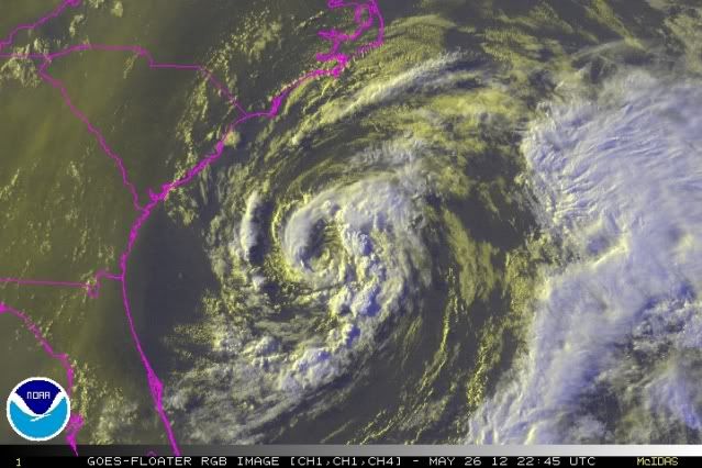
Here is why an upper level low (ULL) is no good for intensification. It prevents good outflow at the top of the system. Notice there are pretty much no high cirrus clouds feathering out at the top levels, thus no outflow and not enough venting above the lower levels. If we start to see some cirrus clouds blowing out above it that would be a good sign for intensification. But none right now.
0 likes
-
Bocadude85
- Category 5
- Posts: 2991
- Age: 39
- Joined: Mon Apr 18, 2005 2:20 pm
- Location: Honolulu,Hi
Re: ATL: BERYL - Subtropical Storm
If Beryl keeps on her current heading she will miss her next forecast point to the southeast
http://www.ssd.noaa.gov/PS/TROP/floaters/02L/java-vis-long.html
http://www.ssd.noaa.gov/PS/TROP/floaters/02L/java-vis-long.html
0 likes
-
cycloneye
- Admin
- Posts: 149291
- Age: 69
- Joined: Thu Oct 10, 2002 10:54 am
- Location: San Juan, Puerto Rico
Re: ATL: BERYL - Recon Discussion
Mission is over!
000
URNT11 KNHC 262245
97779 22434 70300 75308 03600 21028 21213 /0013
42315
RMK AF307 0102A BERYL OB 10
SWS = 13 KTS
SE OUTBOUND LAST REPORT
000
URNT11 KNHC 262245
97779 22434 70300 75308 03600 21028 21213 /0013
42315
RMK AF307 0102A BERYL OB 10
SWS = 13 KTS
SE OUTBOUND LAST REPORT
0 likes
Visit the Caribbean-Central America Weather Thread where you can find at first post web cams,radars
and observations from Caribbean basin members Click Here
and observations from Caribbean basin members Click Here
-
ozonepete
- Professional-Met
- Posts: 4743
- Joined: Mon Sep 07, 2009 3:23 pm
- Location: From Ozone Park, NYC / Now in Brooklyn, NY
Re:
thundercam96 wrote:What Are The Chances Of This System Moving At A More Southerly Pace?
They look pretty low right now. One thing you have to remember is that the models (and the NHC analysis of their output) have gotten really good on track forecasts over the last few years. VERY good actually. I have seen many very smart people second-guess the NHC on track at short range (1 or 2 days) and they are never better. It is intensity where there are still big problems, but not track.
0 likes
-
cycloneye
- Admin
- Posts: 149291
- Age: 69
- Joined: Thu Oct 10, 2002 10:54 am
- Location: San Juan, Puerto Rico
Re: ATL: BERYL - Recon
This mission is over.
000
URNT11 KNHC 262245
97779 22434 70300 75308 03600 21028 21213 /0013
42315
RMK AF307 0102A BERYL OB 10
SWS = 13 KTS
SE OUTBOUND LAST REPORT
000
URNT11 KNHC 262245
97779 22434 70300 75308 03600 21028 21213 /0013
42315
RMK AF307 0102A BERYL OB 10
SWS = 13 KTS
SE OUTBOUND LAST REPORT
0 likes
Visit the Caribbean-Central America Weather Thread where you can find at first post web cams,radars
and observations from Caribbean basin members Click Here
and observations from Caribbean basin members Click Here
Re: ATL: BERYL - Recon Discussion
cycloneye wrote:Mission is over!
000
URNT11 KNHC 262245
97779 22434 70300 75308 03600 21028 21213 /0013
42315
RMK AF307 0102A BERYL OB 10
SWS = 13 KTS
SE OUTBOUND LAST REPORT
Unexpected, usually there is another sweep...
0 likes
-
cycloneye
- Admin
- Posts: 149291
- Age: 69
- Joined: Thu Oct 10, 2002 10:54 am
- Location: San Juan, Puerto Rico
Re: ATL: BERYL - Recon
Next mission will start around 5:15 AM EDT.
Code: Select all
FLIGHT TWO -- TEAL 71
       A. 27/1200Z
       B. AFXXX 0202A CYCLONE
       C. 27/0915Z
       D. 30.8N 79.5W
       E. 27/1130Z TO 27/1630Z
       F. SFC TO 10,000 FT
0 likes
Visit the Caribbean-Central America Weather Thread where you can find at first post web cams,radars
and observations from Caribbean basin members Click Here
and observations from Caribbean basin members Click Here
-
weatherSnoop
- S2K Supporter
- Posts: 702
- Age: 63
- Joined: Wed Oct 09, 2002 10:06 pm
- Location: Tampa, FL
- Contact:
-
hurricanefloyd5

- Category 5
- Posts: 1659
- Age: 45
- Joined: Sun May 02, 2004 10:53 am
- Location: Spartanburg
- Contact:
-
thundercam96
- Tropical Storm
- Posts: 129
- Joined: Thu Aug 18, 2011 3:01 pm
- Location: Boston, MA
Re: Re:
ozonepete wrote:thundercam96 wrote:What Are The Chances Of This System Moving At A More Southerly Pace?
They look pretty low right now. One thing you have to remember is that the models (and the NHC analysis of their output) have gotten really good on track forecasts over the last few years. VERY good actually. I have seen many very smart people second-guess the NHC on track at short range (1 or 2 days) and they are never better. It is intensity where there are still big problems, but not track.
So It Probably Wont Make Landfall Anywhere South Of St. Augustine?
0 likes
Fay '08 / Mathew 16'
Personal Forecast Disclaimer: I am not a certified meteorologist, therefore, what is posted on this forum under my header should not be treated as an official forecast. Please refer to the NWS/NHC products for forecast information.
Personal Forecast Disclaimer: I am not a certified meteorologist, therefore, what is posted on this forum under my header should not be treated as an official forecast. Please refer to the NWS/NHC products for forecast information.
-
cycloneye
- Admin
- Posts: 149291
- Age: 69
- Joined: Thu Oct 10, 2002 10:54 am
- Location: San Juan, Puerto Rico
Re: ATL: BERYL - Advisories
BULLETIN
SUBTROPICAL STORM BERYL INTERMEDIATE ADVISORY NUMBER 4A
NWS NATIONAL HURRICANE CENTER MIAMI FL AL022012
800 PM EDT SAT MAY 26 2012
...HURRICANE HUNTERS FIND THAT BERYL IS A LITTLE STRONGER...
SUMMARY OF 800 PM EDT...0000 UTC...INFORMATION
----------------------------------------------
LOCATION...31.1N 76.9W
ABOUT 220 MI...350 KM SE OF CHARLESTON SOUTH CAROLINA
ABOUT 290 MI...465 KM E OF JACKSONVILLE FLORIDA
MAXIMUM SUSTAINED WINDS...50 MPH...80 KM/H
PRESENT MOVEMENT...SW OR 235 DEGREES AT 6 MPH...9 KM/H
MINIMUM CENTRAL PRESSURE...998 MB...29.47 INCHES
WATCHES AND WARNINGS
--------------------
CHANGES WITH THIS ADVISORY...
NONE.
SUMMARY OF WATCHES AND WARNINGS IN EFFECT...
A TROPICAL STORM WARNING IS IN EFFECT FOR...
* VOLUSIA/BREVARD COUNTY LINE FLORIDA TO EDISTO BEACH SOUTH CAROLINA
A TROPICAL STORM WATCH IS IN EFFECT FOR...
* NORTH OF EDISTO BEACH TO SOUTH SANTEE RIVER SOUTH CAROLINA
FOR STORM INFORMATION SPECIFIC TO YOUR AREA...INCLUDING POSSIBLE
INLAND WATCHES AND WARNINGS...PLEASE MONITOR PRODUCTS ISSUED BY
YOUR LOCAL NATIONAL WEATHER SERVICE FORECAST OFFICE.
DISCUSSION AND 48-HOUR OUTLOOK
------------------------------
AT 800 PM EDT...0000 UTC...THE CENTER OF SUBTROPICAL STORM BERYL WAS
LOCATED NEAR LATITUDE 31.1 NORTH...LONGITUDE 76.9 WEST. THE STORM IS
MOVING TOWARD THE SOUTHWEST NEAR 6 MPH...9 KM/H...AND THIS GENERAL
MOTION IS FORECAST TO CONTINUE THROUGH EARLY SUNDAY. A TURN TOWARD
THE WEST IS EXPECTED LATE SUNDAY. ON THE FORECAST TRACK...THE CENTER
OF BERYL WILL BE NEAR THE COAST WITHIN THE WARNING AREA BY LATE
SUNDAY.
REPORTS FROM AN AIR FORCE RESERVE HURRICANE HUNTER AIRCRAFT INDICATE
THAT MAXIMUM SUSTAINED WINDS ARE NOW NEAR 50 MPH...80 KM/H...WITH
HIGHER GUSTS. LITTLE CHANGE IN STRENGTH IS EXPECTED DURING THE
NEXT DAY OR TWO WHILE THE CENTER REMAINS OVER WATER.
TROPICAL-STORM-FORCE WINDS EXTEND OUTWARD UP TO 90 MILES...145 KM
FROM THE CENTER.
THE HURRICANE HUNTER AIRCRAFT RECENTLY REPORTED A MINIMUM CENTRAL
PRESSURE OF 998 MB...29.47 INCHES.
HAZARDS AFFECTING LAND
----------------------
WIND...TROPICAL STORM CONDITIONS ARE EXPECTED TO REACH THE COAST
WITHIN THE WARNING AREA FROM NORTHEASTERN FLORIDA TO SOUTH CAROLINA
ON SUNDAY. TROPICAL STORM CONDITIONS ARE POSSIBLE IN THE WATCH AREA
ALONG THE CENTRAL SOUTH CAROLINA COAST LATE TONIGHT OR ON SUNDAY.
STORM SURGE...THE COMBINATION OF A STORM SURGE AND THE TIDE WILL
CAUSE NORMALLY DRY AREAS NEAR THE COAST TO BE FLOODED BY RISING
WATERS. THE WATER COULD REACH THE FOLLOWING DEPTHS ABOVE GROUND IF
THE PEAK SURGE OCCURS AT THE TIME OF HIGH TIDE...
COASTAL PORTIONS OF SOUTH CAROLINA...GEORGIA...AND NORTH FLORIDA...
1 TO 3 FT
THE DEEPEST WATER WILL OCCUR ALONG THE IMMEDIATE COAST NEAR AND TO
THE NORTH OF THE LANDFALL LOCATION...WHERE THE SURGE WILL BE
ACCOMPANIED BY LARGE WAVES. SURGE-RELATED FLOODING DEPENDS ON THE
RELATIVE TIMING OF THE SURGE AND THE TIDAL CYCLE...AND CAN VARY
GREATLY OVER SHORT DISTANCES. FOR INFORMATION SPECIFIC TO YOUR
AREA...PLEASE SEE PRODUCTS ISSUED BY YOUR LOCAL NATIONAL WEATHER
SERVICE OFFICE.
SURF...DANGEROUS SURF CONDITIONS ARE POSSIBLE ALONG THE COAST FROM
NORTHEASTERN FLORIDA TO NORTH CAROLINA OVER THE MEMORIAL DAY
WEEKEND. PLEASE SEE STATEMENTS ISSUED BY YOUR LOCAL NATIONAL
WEATHER SERVICE OFFICE FOR INFORMATION SPECIFIC TO YOUR AREA.
RAINFALL...BERYL IS EXPECTED TO PRODUCE TOTAL RAIN ACCUMULATIONS OF
3 TO 6 INCHES ALONG THE SOUTHEASTERN COAST OF THE UNITED STATES
FROM NORTHERN FLORIDA THROUGH SOUTHEASTERN NORTH CAROLINA.
NEXT ADVISORY
-------------
NEXT COMPLETE ADVISORY...1100 PM EDT.
$$
FORECASTER BEVEN/KIMBERLAIN
0 likes
Visit the Caribbean-Central America Weather Thread where you can find at first post web cams,radars
and observations from Caribbean basin members Click Here
and observations from Caribbean basin members Click Here
-
TropicalAnalystwx13

- Category 5
- Posts: 2109
- Age: 28
- Joined: Tue Jul 19, 2011 8:20 pm
- Location: Wilmington, NC
- Contact:
BULLETIN
SUBTROPICAL STORM BERYL INTERMEDIATE ADVISORY NUMBER 4A
NWS NATIONAL HURRICANE CENTER MIAMI FL AL022012
800 PM EDT SAT MAY 26 2012
...HURRICANE HUNTERS FIND THAT BERYL IS A LITTLE STRONGER...
SUMMARY OF 800 PM EDT...0000 UTC...INFORMATION
----------------------------------------------
LOCATION...31.1N 76.9W
ABOUT 220 MI...350 KM SE OF CHARLESTON SOUTH CAROLINA
ABOUT 290 MI...465 KM E OF JACKSONVILLE FLORIDA
MAXIMUM SUSTAINED WINDS...50 MPH...80 KM/H
PRESENT MOVEMENT...SW OR 235 DEGREES AT 6 MPH...9 KM/H
MINIMUM CENTRAL PRESSURE...998 MB...29.47 INCHES
0 likes
Who is online
Users browsing this forum: No registered users and 15 guests