2025 Global Model Runs Discussion (Out thru day 16)
Moderator: S2k Moderators
Forum rules

The posts in this forum are NOT official forecasts and should not be used as such. They are just the opinion of the poster and may or may not be backed by sound meteorological data. They are NOT endorsed by any professional institution or STORM2K. For official information, please refer to products from the National Hurricane Center and National Weather Service.


Re: 2025 Global Model Runs Discussion (Out thru day 16)
It’s the pattern. Hey LAF92, I went ahead and watched the first 12 minutes of Saturday summary (hurricane portion anyway), and it’s basically what I posted above. Probably worth your time to watch that portion which he’s got graphics.
1 likes
Re: 2025 Global Model Runs Discussion (Out thru day 16)
336 Hour gfs ensembles, other than a short lived weak thing off a front along the Mid Atlantic, this looks more like June. Something at the tail end in the MDR, but not a strong signal (And not on operationals) One way I tell if we're active or not is if you can use the MLSP surface charts or percip models to find anything on the operational models, if you need to use the 850mb voracity to even find a hint, it's dead. Not even a hint of anything from 99L either.

Google Deep Mind Ensembles:

Could switch up by the second half of September, but for now it's still about as quiet as late August could be in the Atlantic. The one wave that does show up in the MDR in the ensembles leaves Africa on Labor Day, but it's not in any operationals.
Google Deep Mind Ensembles:
Could switch up by the second half of September, but for now it's still about as quiet as late August could be in the Atlantic. The one wave that does show up in the MDR in the ensembles leaves Africa on Labor Day, but it's not in any operationals.
Last edited by BobHarlem on Mon Aug 25, 2025 6:03 am, edited 1 time in total.
2 likes
-
tropicwatch

- Category 5

- Posts: 3427
- Age: 62
- Joined: Sat Jun 02, 2007 10:01 am
- Location: The Villages, Florida
- Contact:
Re: 2025 Global Model Runs Discussion (Out thru day 16)
Time to watch the fronts. Forecast Models sometimes have a hard time sniffing out development from these features.
2 likes
Tropicwatch
Agnes 72', Eloise 75, Elena 85', Kate 85', Charley 86', Florence 88', Beryl 94', Dean 95', Erin 95', Opal 95', Earl 98', Georges 98', Ivan 2004', Arlene 2005', Dennis 2005', Ida 2009' Debby 2012' Irma 2017' Michael 2018'
Agnes 72', Eloise 75, Elena 85', Kate 85', Charley 86', Florence 88', Beryl 94', Dean 95', Erin 95', Opal 95', Earl 98', Georges 98', Ivan 2004', Arlene 2005', Dennis 2005', Ida 2009' Debby 2012' Irma 2017' Michael 2018'
-
StormWeather

- Category 1

- Posts: 477
- Joined: Wed Jun 05, 2024 2:34 pm
Re: 2025 Global Model Runs Discussion (Out thru day 16)
EURO hinting at a few circulations in the CPAC, and the 00Z run of Easterlywave had several members crossing the IDL and moving into the WPAC.
0 likes
Just an average cyclone tracker
The posts in this forum are NOT official forecasts and should not be used as such. They are just the opinion of the poster and may or may not be backed by sound meteorological data. They are NOT endorsed by any professional institution or storm2k.org. For official information, please refer to the NHC and NWS products
The posts in this forum are NOT official forecasts and should not be used as such. They are just the opinion of the poster and may or may not be backed by sound meteorological data. They are NOT endorsed by any professional institution or storm2k.org. For official information, please refer to the NHC and NWS products
-
cycloneye

- Admin

- Posts: 149719
- Age: 69
- Joined: Thu Oct 10, 2002 10:54 am
- Location: San Juan, Puerto Rico
Re: 2025 Global Model Runs Discussion (Out thru day 16)
This is for September 10th (Peak day) and is not common to see it without TC's on that particular day. I guess there are not many years that are like this in the archives.

0 likes
Visit the Caribbean-Central America Weather Thread where you can find at first post web cams,radars
and observations from Caribbean basin members Click Here
and observations from Caribbean basin members Click Here
Re: 2025 Global Model Runs Discussion (Out thru day 16)
BobHarlem wrote:336 Hour gfs ensembles, other than a short lived weak thing off a front along the Mid Atlantic, this looks more like June. Something at the tail end in the MDR, but not a strong signal (And not on operationals) One way I tell if we're active or not is if you can use the MLSP surface charts or percip models to find anything on the operational models, if you need to use the 850mb voracity to even find a hint, it's dead. Not even a hint of anything from 99L either.
https://i.imgur.com/f9T9ng2.png
Google Deep Mind Ensembles:
https://i.imgur.com/L8sqKq1.png
Could switch up by the second half of September, but for now it's still about as quiet as late August could be in the Atlantic. The one wave that does show up in the MDR in the ensembles leaves Africa on Labor Day, but it's not in any operationals.
This kind of reminds me of the 2024 19 day lull of no storms during the first half of peak season.
5 likes
Personal Forecast Disclaimer:
The posts in this forum are NOT official forecasts and should not be used as such. They are just the opinion of the poster and may or may not be backed by sound meteorological data. They are NOT endorsed by any professional institution or storm2k.org. For official information, please refer to the NHC and NWS products.
The posts in this forum are NOT official forecasts and should not be used as such. They are just the opinion of the poster and may or may not be backed by sound meteorological data. They are NOT endorsed by any professional institution or storm2k.org. For official information, please refer to the NHC and NWS products.
-
StormWeather
- Category 1
- Posts: 477
- Joined: Wed Jun 05, 2024 2:34 pm
Re: 2025 Global Model Runs Discussion (Out thru day 16)
StormWeather wrote:EURO hinting at a few circulations in the CPAC, and the 00Z run of Easterlywave had several members crossing the IDL and moving into the WPAC.
12Z GFS run on board with this. Spins up a short-lived 998 mb system in the CPAC as it approaches the IDL.
0 likes
Just an average cyclone tracker
The posts in this forum are NOT official forecasts and should not be used as such. They are just the opinion of the poster and may or may not be backed by sound meteorological data. They are NOT endorsed by any professional institution or storm2k.org. For official information, please refer to the NHC and NWS products
The posts in this forum are NOT official forecasts and should not be used as such. They are just the opinion of the poster and may or may not be backed by sound meteorological data. They are NOT endorsed by any professional institution or storm2k.org. For official information, please refer to the NHC and NWS products
-
Stratton23
- Category 5
- Posts: 3575
- Joined: Fri Jul 21, 2023 10:59 pm
- Location: Katy, Tx
Re: 2025 Global Model Runs Discussion (Out thru day 16)
Wouldn’t be the least bit surprised if we saw 1-2 homegrown systems in the atlantic over the next 2 weeks while the MDR goes quiet, models continue to show several decent fronts making progress into the gulf over the next 10-14 days, lots of energy in the gulf and se coast but nothing consolidating yet, worth watching though
0 likes
Re: 2025 Global Model Runs Discussion (Out thru day 16)
For the record and fwiw, the 12Z UKMET is its first run with a TD forming at 132 hours in the E Atlantic and moving WSW. This could easily be gone on the next run and seems like a big longshot when considering other models and ensembles: 17.6N, 17.6W 
If this were real, the Cabo Verde Islands would get another hit in 2025!
If this were real, the Cabo Verde Islands would get another hit in 2025!
NEW TROPICAL CYCLONE FORECAST TO DEVELOP AFTER 132 HOURS
FORECAST POSITION AT T+132 : 17.6N 17.6W
LEAD CENTRAL MAXIMUM WIND
VERIFYING TIME TIME POSITION PRESSURE (MB) SPEED (KNOTS)
-------------- ---- -------- ------------- -------------
0000UTC 31.08.2025 132 17.6N 17.6W 1010 25
1200UTC 31.08.2025 144 17.3N 19.7W 1010 24
0000UTC 01.09.2025 156 17.2N 22.2W 1011 23
1200UTC 01.09.2025 168 16.7N 25.6W 1012 25
Last edited by LarryWx on Mon Aug 25, 2025 12:12 pm, edited 1 time in total.
1 likes
Personal Forecast Disclaimer:
The posts in this forum are NOT official forecasts and should not be used as such. They are just the opinion of the poster and may or may not be backed by sound meteorological data. They are NOT endorsed by any professional institution or storm2k.org. For official information, please refer to the NHC and NWS products.
The posts in this forum are NOT official forecasts and should not be used as such. They are just the opinion of the poster and may or may not be backed by sound meteorological data. They are NOT endorsed by any professional institution or storm2k.org. For official information, please refer to the NHC and NWS products.
-
tolakram
- Admin
- Posts: 20186
- Age: 62
- Joined: Sun Aug 27, 2006 8:23 pm
- Location: Florence, KY (name is Mark)
Re: 2025 Global Model Runs Discussion (Out thru day 16)
Concerning numerous posts from various users:
This is a model runs thread, not a social media thread. Just expect your posts to vanish if off topic. Every year we get season cancel crap that drifts into just about every thread and drives multiple mods crazy. I don't care, they don't care, most of us don't care. Not sure how to politely phrase that. Feel free to create a 2025 season cancel thread and talk away.
This is a model runs thread, not a social media thread. Just expect your posts to vanish if off topic. Every year we get season cancel crap that drifts into just about every thread and drives multiple mods crazy. I don't care, they don't care, most of us don't care. Not sure how to politely phrase that. Feel free to create a 2025 season cancel thread and talk away.
13 likes
M a r k
- - - - -
Join us in chat: Storm2K Chatroom Invite. Android and IOS apps also available.
The posts in this forum are NOT official forecasts and should not be used as such. Posts are NOT endorsed by any professional institution or STORM2K.org. For official information and forecasts, please refer to NHC and NWS products.
Re: 2025 Global Model Runs Discussion (Out thru day 16)
LarryWx wrote:For the record and fwiw, the 12Z UKMET is its first run with a TD forming at 132 hours in the E Atlantic and moving WSW. This could easily be gone on the next run and seems like a big longshot when considering other models and ensembles: 17.6N, 17.6W
If this were real, the Cabo Verde Islands would get another hit in 2025!NEW TROPICAL CYCLONE FORECAST TO DEVELOP AFTER 132 HOURS
FORECAST POSITION AT T+132 : 17.6N 17.6W
LEAD CENTRAL MAXIMUM WIND
VERIFYING TIME TIME POSITION PRESSURE (MB) SPEED (KNOTS)
-------------- ---- -------- ------------- -------------
0000UTC 31.08.2025 132 17.6N 17.6W 1010 25
1200UTC 31.08.2025 144 17.3N 19.7W 1010 24
0000UTC 01.09.2025 156 17.2N 22.2W 1011 23
1200UTC 01.09.2025 168 16.7N 25.6W 1012 25
Actually, I need to retract what I said above, “This could easily be gone on the next run and seems like a big longshot when considering other models..”
I just looked at other 12Z ops and there’s actually the same general idea of a LL circ forming just off Africa within 6 days from these 12Z models: Euro, CMC, Icon, and JMA in addition to the UKMET. The GFS is about the only major op that has virtually nothing. Hmmmm.
0 likes
Personal Forecast Disclaimer:
The posts in this forum are NOT official forecasts and should not be used as such. They are just the opinion of the poster and may or may not be backed by sound meteorological data. They are NOT endorsed by any professional institution or storm2k.org. For official information, please refer to the NHC and NWS products.
The posts in this forum are NOT official forecasts and should not be used as such. They are just the opinion of the poster and may or may not be backed by sound meteorological data. They are NOT endorsed by any professional institution or storm2k.org. For official information, please refer to the NHC and NWS products.

Re: 2025 Global Model Runs Discussion (Out thru day 16)
tropicwatch wrote:Time to watch the fronts. Forecast Models sometimes have a hard time sniffing out development from these features.
That is something I have concerns about.
I am not aware of any forecast models that have Mesoscale Convective System (MCS) from frontal boundaries becoming tropical in nature. The forecast models tend to forecast tropical waves becoming hurricanes.
0 likes
Re: 2025 Global Model Runs Discussion (Out thru day 16)
0Z followup to all 12Z major ops but GFS showing a surface low forming just off of Africa this weekend:
0Z Icon like 12Z has a sfc low just off Africa Sat. It becomes a TD that day and then a TS by Sun.
0Z Icon like 12Z has a sfc low just off Africa Sat. It becomes a TD that day and then a TS by Sun.
0 likes
Personal Forecast Disclaimer:
The posts in this forum are NOT official forecasts and should not be used as such. They are just the opinion of the poster and may or may not be backed by sound meteorological data. They are NOT endorsed by any professional institution or storm2k.org. For official information, please refer to the NHC and NWS products.
The posts in this forum are NOT official forecasts and should not be used as such. They are just the opinion of the poster and may or may not be backed by sound meteorological data. They are NOT endorsed by any professional institution or storm2k.org. For official information, please refer to the NHC and NWS products.
-
Category5Kaiju

- Category 5
- Posts: 4346
- Joined: Thu Dec 24, 2020 12:45 pm
- Location: Seattle during the summer, Phoenix during the winter
Re: 2025 Global Model Runs Discussion (Out thru day 16)
0z ICON develops a storm right as it splashes down off the coast of Mauritania and has it pass through the Cape Verde islands before heading WNW. Mind you, this happens on Labor Day weekend, so not far from now.
Perhaps another Cape Verde system is in the works?
Perhaps another Cape Verde system is in the works?
0 likes
Unless explicitly stated, all information in my posts is based on my own opinions and observations. Tropical storms and hurricanes can be extremely dangerous. Refer to an accredited weather research agency or meteorologist if you need to make serious decisions regarding an approaching storm.
Re: 2025 Global Model Runs Discussion (Out thru day 16)
Category5Kaiju wrote:0z ICON develops a storm right as it splashes down off the coast of Mauritania and has it pass through the Cape Verde islands before heading WNW. Mind you, this happens on Labor Day weekend, so not far from now.
Perhaps another Cape Verde system is in the works?
OZ:
-UKMET dropped it as a TC
-GFS still doesn’t have anything
-CMC still has a very weak version but it’s even weaker than 12Z
-Euro not out yet
0 likes
Personal Forecast Disclaimer:
The posts in this forum are NOT official forecasts and should not be used as such. They are just the opinion of the poster and may or may not be backed by sound meteorological data. They are NOT endorsed by any professional institution or storm2k.org. For official information, please refer to the NHC and NWS products.
The posts in this forum are NOT official forecasts and should not be used as such. They are just the opinion of the poster and may or may not be backed by sound meteorological data. They are NOT endorsed by any professional institution or storm2k.org. For official information, please refer to the NHC and NWS products.

Re: 2025 Global Model Runs Discussion (Out thru day 16)
Category5Kaiju wrote:0z ICON develops a storm right as it splashes down off the coast of Mauritania and has it pass through the Cape Verde islands before heading WNW. Mind you, this happens on Labor Day weekend, so not far from now.
Perhaps another Cape Verde system is in the works?
That might be the same wave that Larry said the UKMET was picking up on. Nvm he just clarified that lol
1 likes
Re: 2025 Global Model Runs Discussion (Out thru day 16)
LAF92 wrote:Category5Kaiju wrote:0z ICON develops a storm right as it splashes down off the coast of Mauritania and has it pass through the Cape Verde islands before heading WNW. Mind you, this happens on Labor Day weekend, so not far from now.
Perhaps another Cape Verde system is in the works?
That might be the same wave that Larry said the UKMET was picking up on. Nvm he just clarified that lol
The 0Z CMC like the 12Z is a much weaker version of the Icon but it is significantly further S.
1 likes
Personal Forecast Disclaimer:
The posts in this forum are NOT official forecasts and should not be used as such. They are just the opinion of the poster and may or may not be backed by sound meteorological data. They are NOT endorsed by any professional institution or storm2k.org. For official information, please refer to the NHC and NWS products.
The posts in this forum are NOT official forecasts and should not be used as such. They are just the opinion of the poster and may or may not be backed by sound meteorological data. They are NOT endorsed by any professional institution or storm2k.org. For official information, please refer to the NHC and NWS products.

Re: 2025 Global Model Runs Discussion (Out thru day 16)
I kinda expected 99L to develop at some point, but since it hasn't it looks like we're in for a quiet period. Below the Euro and GFS ensembles, which show some MDR action near the 10-day mark. But until then, not much.
Euro (+240hr)

GEFS (+240hr)

GEFS (+336hr)

Euro (+240hr)
GEFS (+240hr)
GEFS (+336hr)
0 likes
Re: 2025 Global Model Runs Discussion (Out thru day 16)
LAF92 wrote:Category5Kaiju wrote:0z ICON develops a storm right as it splashes down off the coast of Mauritania and has it pass through the Cape Verde islands before heading WNW. Mind you, this happens on Labor Day weekend, so not far from now.
Perhaps another Cape Verde system is in the works?
That might be the same wave that Larry said the UKMET was picking up on. Nvm he just clarified that lol
The Euro (0Z) has this again as a weak low just off Africa. It then eventually comes across to just N of the Leewards as a H moving NW though those details aren’t important so far out on an operational.
The EPS (0Z) again has a few TC members from this and they all are headed for a safe recurve from the US.
The Icon (6Z) has this again at 120 just off Africa.
The GFS (6Z) again doesn’t have this develop.
0 likes
Personal Forecast Disclaimer:
The posts in this forum are NOT official forecasts and should not be used as such. They are just the opinion of the poster and may or may not be backed by sound meteorological data. They are NOT endorsed by any professional institution or storm2k.org. For official information, please refer to the NHC and NWS products.
The posts in this forum are NOT official forecasts and should not be used as such. They are just the opinion of the poster and may or may not be backed by sound meteorological data. They are NOT endorsed by any professional institution or storm2k.org. For official information, please refer to the NHC and NWS products.

Re: 2025 Global Model Runs Discussion (Out thru day 16)
With the caveat that 360 hr model runs are not to be taken literally... The (supposedly conservative) 0z ECMWF has two CV storms at the end of the run.
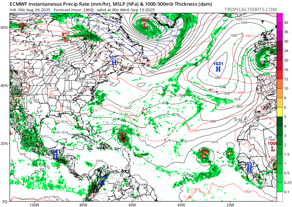
1 likes
TC naming lists: retirements and intensity
Most aggressive Advisory #1's in North Atlantic (cr. kevin for starting the list)
Most aggressive Advisory #1's in North Atlantic (cr. kevin for starting the list)