ATL: IKE Discussion

Moderator: S2k Moderators

Message
Author
rtd2
Category 5
Category 5
Posts: 1183
Joined: Tue Aug 12, 2003 12:45 pm
Location: Biloxi, MS

Re: ATL IKE: Category 2 - Discussion

#7781 Postby rtd2 » Wed Sep 10, 2008 3:29 pm

terrapintransit wrote:
Stormcenter wrote:
terrapintransit wrote:The more strength Ike attains the more northerly he will go.... :eek:


Huh?


I believe I heard Steve Lyons talking about this at one time...


you did and for the most part its true 'canes natural motion is to go poleward but there is alot of other factors and IKE's no where near strong enough to create or influence his own enviroment. it can and does happen though ESPECIALLY close to land imho
0 likes   

User avatar
SMNederlandTX
Tropical Depression
Tropical Depression
Posts: 57
Age: 50
Joined: Fri Aug 17, 2007 7:02 pm
Location: Nederland, TX

Re: ATL IKE: Category 2 - Discussion

#7782 Postby SMNederlandTX » Wed Sep 10, 2008 3:29 pm

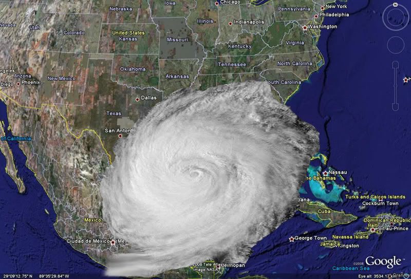
Now, I may be wrong on this one, so correct me please, if I am. I thought I read from several posters that Rita and Katrina both had no dry air to contend with and that was one of several things that made them so powerful.....And Rita produced a lot of tornadoes from what I read. Oops....LOL forgot to post the rest :oops:
Anyways....Ike is supposedly dealing with dry air, that is one of the reasons he is not as strong as those...ok am I making any sense...? LOL

N2Storms wrote:
Lowpressure wrote:
SMNederlandTX wrote:I don't know if this can be forecasted or not....but does anyone know if there will be a lot of tornadoes with this and if so, how far from the center do you think they will occur? Probably a stupid question...but kinda curious.... :oops:

Depends on several factors. Usually right front quad is more prone to be tornadic, but as we all saw with Gustav, it really depends on the air pattern that he bumps into over land.


quite frequently, if the storm is ingesting a lot of dry air it will tend to produce more tornadoes
Last edited by SMNederlandTX on Wed Sep 10, 2008 3:36 pm, edited 1 time in total.
0 likes   

User avatar
Sabanic
Category 2
Category 2
Posts: 683
Age: 65
Joined: Wed Aug 01, 2007 7:01 am
Location: Mobile, AL
Contact:

Re: ATL IKE: Category 2 - Discussion

#7783 Postby Sabanic » Wed Sep 10, 2008 3:29 pm

Lowpressure wrote:
SMNederlandTX wrote:I don't know if this can be forecasted or not....but does anyone know if there will be a lot of tornadoes with this and if so, how far from the center do you think they will occur? Probably a stupid question...but kinda curious.... :oops:

Depends on several factors. Usually right front quad is more prone to be tornadic, but as we all saw with Gustav, it really depends on the air pattern that he bumps into over land.


The amount of moisture a storm can draw also is a major contributor. Fay rode the Gulf Coast and was able to draw from the GOM for a long period of time. In the bands were many squalls and the majority of the tornadic activity was in the feeder bands. Gustav also drew mositure from the GOM for a good while. Not that the moisture is the main contibutor, but basically the more thunderstorm activity in the squalls the more chance for tornadoes.
Last edited by Sabanic on Wed Sep 10, 2008 3:30 pm, edited 1 time in total.
0 likes   

User avatar
dixiebreeze
S2K Supporter
S2K Supporter
Posts: 5140
Joined: Wed Sep 03, 2003 5:07 pm
Location: crystal river, fla.

Re: ATL IKE: Category 2 - Discussion

#7784 Postby dixiebreeze » Wed Sep 10, 2008 3:30 pm

Deep pressure drop here:

Station 42001 - MID GULF 180 nm South of Southwest Pass, LA

Owned and maintained by National Data Buoy Center
12-meter discus buoy
ARES payload
25.900 N 89.667 W (25°54'0" N 89°40'0" W)

Site elevation: sea level
Air temp height: 10 m above site elevation
Anemometer height: 10 m above site elevation
Barometer elevation: sea level
Sea temp depth: 1 m below site elevation
Water depth: 3246 m
Watch circle radius: 3172 yards

Latest Satellite Wind Map for this Area
Conditions at 42001 as of
(2:50 pm CDT)

Wind Direction (WDIR): NE ( 40 deg true )
Wind Speed (WSPD): 21.4 kts
Wind Gust (GST): 25.3 kts
Wave Height (WVHT): 16.4 ft
Dominant Wave Period (DPD): 13 sec
Average Period (APD): 8.9 sec
Atmospheric Pressure (PRES): 29.69 in
Pressure Tendency (PTDY): -0.06 in ( Falling )
Air Temperature (ATMP): 82.6 °F
Water Temperature (WTMP): 84.9 °F
Dew Point (DEWP): 73.8 °F
Heat Index (HEAT): 88.7 °F
Combined plot of Wind Speed, Gust, and Air Pressure
Continuous Winds TIME
(CDT) WDIR WSPD
2:50 pm NE ( 36 deg ) 21.6 kts
2:40 pm NE ( 38 deg ) 22.9 kts
2:30 pm NE ( 41 deg ) 23.3 kts
2:20 pm NE ( 44 deg ) 22.5 kts
2:10 pm NE ( 40 deg ) 23.3 kts
2:00 pm NE ( 43 deg ) 27.2 kts
0 likes   

User avatar
KatDaddy
Category 5
Category 5
Posts: 2815
Joined: Mon Oct 21, 2002 6:23 pm
Location: League City, Texas

#7785 Postby KatDaddy » Wed Sep 10, 2008 3:31 pm

The trend of moving E has started. Hoping like hell the trend continues. Not to wish this on anyone but the HOU-GAL areas dont need it.
0 likes   

N2Storms
Category 1
Category 1
Posts: 324
Joined: Thu Sep 04, 2003 1:37 pm
Location: Panama City, Florida

Re:

#7786 Postby N2Storms » Wed Sep 10, 2008 3:32 pm

[quote="KatDaddy"]The trend of moving E has started. Hoping like hell the trend continues. Not to wish this on anyone but the HOU-GAL areas dont need it.[/quote]


Kat...are you alright?
0 likes   

Myersgirl
Tropical Storm
Tropical Storm
Posts: 216
Joined: Fri Jul 23, 2004 7:32 pm
Location: Fort Myers
Contact:

Re: ATL IKE: Category 2 - Discussion

#7787 Postby Myersgirl » Wed Sep 10, 2008 3:33 pm

I have been working all day and wondering why these clouds are still hanging thick. Looking at satellite, is Ike almost 1 degree NE of next forecast point and slowing? By the way is this thing also expanding? Best of Luck Texas, here is hoping he falls apart!
0 likes   

Matt-hurricanewatcher

Re: ATL IKE: Category 2 - Discussion

#7788 Postby Matt-hurricanewatcher » Wed Sep 10, 2008 3:36 pm

Image

Image

:eek: :double:

Full creit to Memeber Jevo...


So far Ike is big but not close to tips. We will see how big he gets.
Last edited by Matt-hurricanewatcher on Wed Sep 10, 2008 3:38 pm, edited 1 time in total.
0 likes   

User avatar
cycloneye
Admin
Admin
Posts: 145452
Age: 68
Joined: Thu Oct 10, 2002 10:54 am
Location: San Juan, Puerto Rico

Re: ATL IKE: Recon Discussion

#7789 Postby cycloneye » Wed Sep 10, 2008 3:36 pm

Anyone knows why the Air Force identifies the flight as=AF303 2009A IKE1 That number 1 besides the name.
0 likes   

User avatar
Cape Verde
Category 2
Category 2
Posts: 564
Age: 70
Joined: Tue Aug 31, 2004 5:53 pm
Location: Houston area

Re: ATL IKE: Category 2 - Discussion

#7790 Postby Cape Verde » Wed Sep 10, 2008 3:37 pm

I pruned my big oak trees in front of the house on Monday. I wasn't even thinking about doing it in preparation of Ike. They just needed it.

Right now in Houston, I'll bet every crew is booked at the moment. Luckiest decision I've made in awhile.
0 likes   

User avatar
SMNederlandTX
Tropical Depression
Tropical Depression
Posts: 57
Age: 50
Joined: Fri Aug 17, 2007 7:02 pm
Location: Nederland, TX

Re: ATL IKE: Category 2 - Discussion

#7791 Postby SMNederlandTX » Wed Sep 10, 2008 3:38 pm

When is the next update?
0 likes   

User avatar
terrapintransit
Category 1
Category 1
Posts: 275
Age: 50
Joined: Tue Sep 04, 2007 8:08 pm
Location: Williamsport, Pa

Re: ATL IKE: Category 2 - Discussion

#7792 Postby terrapintransit » Wed Sep 10, 2008 3:38 pm

Matt-hurricanewatcher wrote:Image

Image

:eek: :double:

Full creit to Memeber Jevo...


So far Ike is big but not close to tips. We will see how big he gets.


Is that Blob out in the Central Atlantic Josephine trying to make a come back??
0 likes   

RL3AO
Moderator-Pro Met
Moderator-Pro Met
Posts: 16308
Joined: Thu Jun 14, 2007 10:03 pm
Location: NC

Re: ATL IKE: Recon Discussion

#7793 Postby RL3AO » Wed Sep 10, 2008 3:38 pm

cycloneye wrote:Anyone knows why the Air Force identifies the flight as=AF303 2009A IKE1 That number 1 besides the name.


They had transmission problems or something after takeoff and there were no new hdobs for an hour or so. When they came back, the HDOBs restarted at set #1 and the mission was IKE1.
0 likes   

mascpa
S2K Supporter
S2K Supporter
Posts: 500
Age: 70
Joined: Tue Sep 30, 2003 10:43 am
Location: Jupiter, FL
Contact:

Re: ATL IKE: Category 2 - Discussion

#7794 Postby mascpa » Wed Sep 10, 2008 3:39 pm

Well I certainly hope the debris from your trimming gets picked up before Ike arrives. Otherwose you may have created a lot of missiles to be picked up by the wind.
0 likes   

Nederlander
S2K Supporter
S2K Supporter
Posts: 1250
Joined: Sat Jul 19, 2008 4:28 pm
Location: Conroe, TX

Re: ATL IKE: Category 2 - Discussion

#7795 Postby Nederlander » Wed Sep 10, 2008 3:39 pm

SMNederlandTX wrote:When is the next update?


in about 15 minutes....
0 likes   

User avatar
cycloneye
Admin
Admin
Posts: 145452
Age: 68
Joined: Thu Oct 10, 2002 10:54 am
Location: San Juan, Puerto Rico

Re: ATL IKE: Recon Discussion

#7796 Postby cycloneye » Wed Sep 10, 2008 3:40 pm

RL3AO wrote:
cycloneye wrote:Anyone knows why the Air Force identifies the flight as=AF303 2009A IKE1 That number 1 besides the name.


They had transmission problems or something after takeoff and there were no new hdobs for an hour or so. When they came back, the HDOBs restarted at set #1 and the mission was IKE1.


Thanks for the answer.
0 likes   

User avatar
SMNederlandTX
Tropical Depression
Tropical Depression
Posts: 57
Age: 50
Joined: Fri Aug 17, 2007 7:02 pm
Location: Nederland, TX

Re: ATL IKE: Category 2 - Discussion

#7797 Postby SMNederlandTX » Wed Sep 10, 2008 3:41 pm

Nederlander wrote:
SMNederlandTX wrote:When is the next update?


in about 15 minutes....


Thank you :)

Anyone think there will be any changes in the forecasted path?
0 likes   

Matt-hurricanewatcher

Re: ATL IKE: Category 2 - Discussion

#7798 Postby Matt-hurricanewatcher » Wed Sep 10, 2008 3:42 pm

terrapintransit wrote:
Matt-hurricanewatcher wrote:Image

Image

:eek: :double:

Full creit to Memeber Jevo...


So far Ike is big but not close to tips. We will see how big he gets.


Is that Blob out in the Central Atlantic Josephine trying to make a come back??


Maybe, but as Ike's strengthens expect his outflow jet to strengthen on his east side. So this keeps it on topic for talking about Ike!
0 likes   

User avatar
Lowpressure
S2K Supporter
S2K Supporter
Posts: 2032
Age: 58
Joined: Sun Sep 14, 2003 9:17 am
Location: Charlotte, North Carolina

Re: ATL IKE: Category 2 - Discussion

#7799 Postby Lowpressure » Wed Sep 10, 2008 3:42 pm

Yes, the trailing blob on the IR satellite is the former Josephine. See the separate thread on this as several have picked up on this.
0 likes   

HenkL
S2K Supporter
S2K Supporter
Posts: 2401
Joined: Fri Sep 10, 2004 5:33 pm
Location: Groningen, The Netherlands
Contact:

#7800 Postby HenkL » Wed Sep 10, 2008 3:42 pm

The 1209 mission restarted HDOBs 4 times and came to IKE4 two days ago.
0 likes   


Return to “2008”

Who is online

Users browsing this forum: No registered users and 7 guests