Tropical Wave with low near African Coast

This is the general tropical discussion area. Anyone can take their shot at predicting a storms path.

Moderator: S2k Moderators

Forum rules

The posts in this forum are NOT official forecasts and should not be used as such. They are just the opinion of the poster and may or may not be backed by sound meteorological data. They are NOT endorsed by any professional institution or STORM2K. For official information, please refer to products from the National Hurricane Center and National Weather Service.

Help Support Storm2K
Message
Author
User avatar
drezee
S2K Supporter
S2K Supporter
Posts: 3664
Joined: Mon Jun 09, 2003 12:49 pm
Location: FL

Re: Strong Disturbance off African Coast

#81 Postby drezee » Mon Jul 28, 2008 4:55 pm

drezee 1236 UTC wrote:Based on the high-res visble loops, I would guess the area of low pressure is near 8.5N and 14.5W


Aric Dunn wrote:
cycloneye wrote:Aric,you almost nailed the position of the low.Here is the first ssd plot:

28/1800 UTC 9.2N 15.4W TOO WEAK INV -- Atlantic Ocean

http://www.ssd.noaa.gov/PS/TROP/positions.html


yeah its pretty evident on visible sat loop i posted with it.. not so hard to extrap the center from the curved bands that are rotating around it.


Seems to be moving WNW. I placed it this morning WSW of the 1800z position.
0 likes   

SapphireSea
Category 1
Category 1
Posts: 430
Joined: Wed Aug 24, 2005 12:13 pm
Location: Miami, FL

Re: Tropical Wave with low pressure off African Coast

#82 Postby SapphireSea » Mon Jul 28, 2008 4:58 pm

All the convection associated with this is all part of the ITCZ, this is going to have the same challenges as 94L (Became Dolly 1000+ miles W from where it was classified an invest initially), it will have to disconnect somewhat from the ITCZ and survive the dry air that is present over most of the Atlantic. There is a small chance it can develop in the ITCZ, but we have seen better waves fail, so I believe that's why we wouldn't be surprised if it dies out.

Needless to say, that the future it is uncertain, and this can develop somewhere down the line just like Dolly, and even then if it does decide to get its act together, it wont be a true Cape Verde storm.
Last edited by SapphireSea on Mon Jul 28, 2008 7:27 pm, edited 1 time in total.
0 likes   

Matt-hurricanewatcher

Re: Tropical Wave with low pressure off African Coast

#83 Postby Matt-hurricanewatcher » Mon Jul 28, 2008 5:08 pm

Convection is falling apart. Maybe a "weak" low but we more or less have to see if a LLC can get started. Maybe no development in the next day or so. But maybe if "shear" is low once into the centeral Atlantic is maybe worth watching.
0 likes   

RL3AO
Moderator-Pro Met
Moderator-Pro Met
Posts: 16308
Joined: Thu Jun 14, 2007 10:03 pm
Location: NC

#84 Postby RL3AO » Mon Jul 28, 2008 5:09 pm

Dolly was 94L not 95L.
0 likes   

Aric Dunn
Category 5
Category 5
Posts: 21238
Age: 42
Joined: Sun Sep 19, 2004 9:58 pm
Location: Ready for the Chase.
Contact:

Re: Tropical Wave with low pressure off African Coast

#85 Postby Aric Dunn » Mon Jul 28, 2008 5:28 pm

Matt-hurricanewatcher wrote:Convection is falling apart. Maybe a "weak" low but we more or less have to see if a LLC can get started. Maybe no development in the next day or so. But maybe if "shear" is low once into the centeral Atlantic is maybe worth watching.


honestly convection always looks very similar in systems at this stage. and there is clearly a well defined circulation ( and not to broad) http://www.meteo.psu.edu/~gadomski/SAT_ ... m16ir.html

and looking at the longer loop the circulation is taking shape quite nicely. and considering it just emerged off the coast earlier today im not surprised convection has flared down as they normally do .. This system has better chance than the one that came off last week .. this one is at a much lower latitude and is in a good moisture envelope, there is some light to moderate sal well to the north which in at least the short term is not going to affect it to much. so all in all at this moment i see no reason why it could not become more organized ! as for tomorrow and the next day well that remains to be seen as it all depends on the evolution of the Circualtion meaning how far north does it move if it stays south it will be better off.
0 likes   

Matt-hurricanewatcher

Re: Tropical Wave with low pressure off African Coast

#86 Postby Matt-hurricanewatcher » Mon Jul 28, 2008 5:37 pm

Now that I have looked at the satellite above, it appears that we have a well defined cirulation off the coast of Africa near 9 north/15 west. Looking very good. I'm sorry I was just looking at still large scale images, now that I look in at a loop it does look interesting.
0 likes   

User avatar
cycloneye
Admin
Admin
Posts: 145268
Age: 68
Joined: Thu Oct 10, 2002 10:54 am
Location: San Juan, Puerto Rico

Re: Tropical Wave with low pressure off African Coast

#87 Postby cycloneye » Mon Jul 28, 2008 5:40 pm

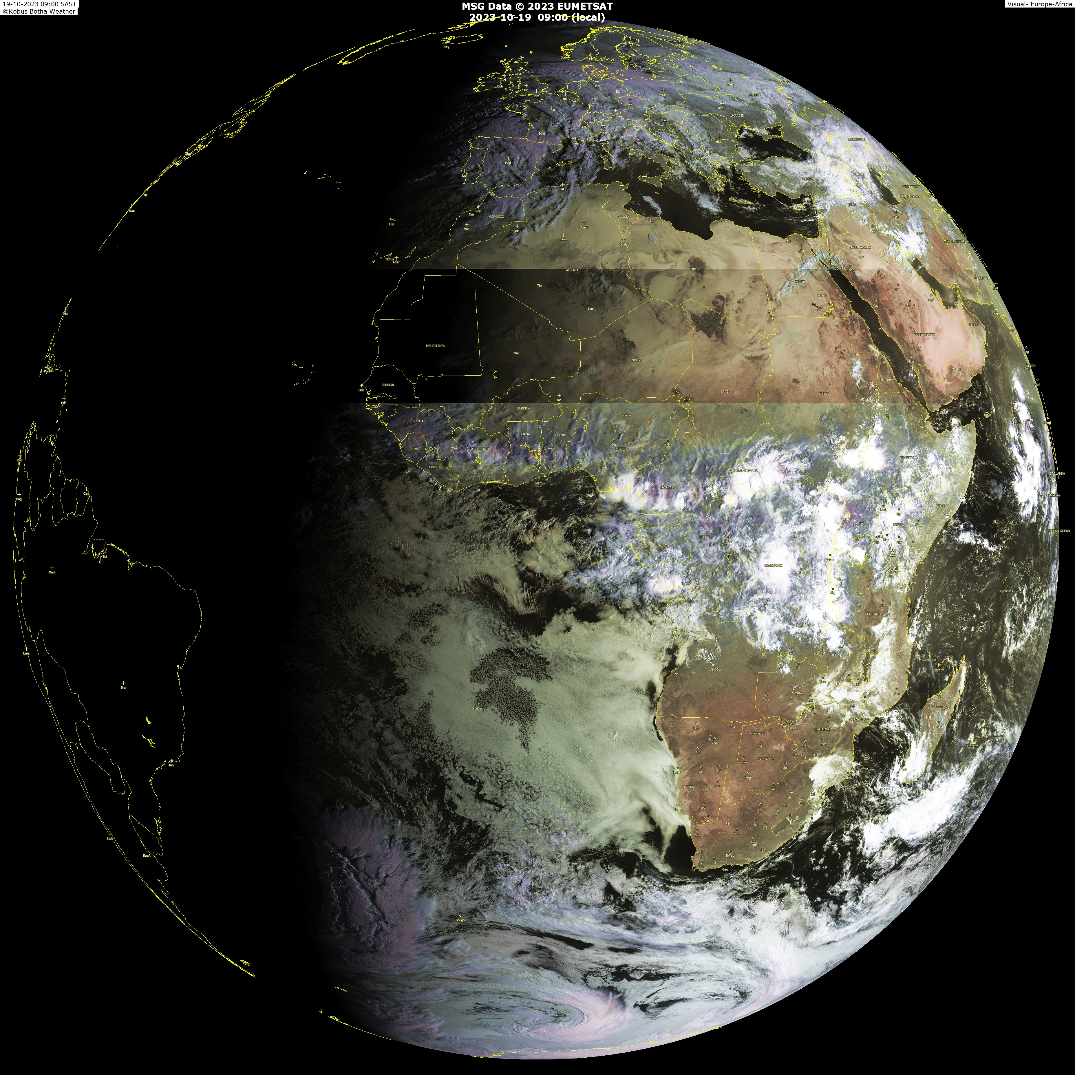
Neat pic where you can see upclose where the low is,near that black ball off the coast below 10n.

Image

http://www.weatherphotos.co.za/photos/world_big.jpg
0 likes   

Sanibel
Category 5
Category 5
Posts: 10375
Joined: Mon Aug 30, 2004 11:06 pm
Location: Offshore SW Florida

Re: Tropical Wave with low pressure off African Coast

#88 Postby Sanibel » Mon Jul 28, 2008 6:16 pm

I think the basin turns a corner over the next 10 days or so.


(More active)
Last edited by Sanibel on Mon Jul 28, 2008 6:19 pm, edited 1 time in total.
0 likes   

fasterdisaster
Category 5
Category 5
Posts: 1868
Joined: Mon Sep 19, 2005 4:41 pm
Location: Miami, Florida

Re: Tropical Wave with low pressure off African Coast

#89 Postby fasterdisaster » Mon Jul 28, 2008 6:17 pm

Sanibel wrote:I think the basin turns a corner over the next 10 days or so.


Do you mean more active or less active?
0 likes   

User avatar
cycloneye
Admin
Admin
Posts: 145268
Age: 68
Joined: Thu Oct 10, 2002 10:54 am
Location: San Juan, Puerto Rico

Re: Tropical Wave with low pressure off African Coast

#90 Postby cycloneye » Mon Jul 28, 2008 6:33 pm

043
ABNT20 KNHC 282332
TWOAT
TROPICAL WEATHER OUTLOOK
NWS TPC/NATIONAL HURRICANE CENTER MIAMI FL
800 PM EDT MON JUL 28 2008

FOR THE NORTH ATLANTIC...CARIBBEAN SEA AND THE GULF OF MEXICO...

A TROPICAL WAVE HAS EMERGED OFF THE WEST COAST OF AFRICA AND SHOWS
SOME SIGNS OF ORGANIZATION. SOME SLOW DEVELOPMENT OF THIS SYSTEM
IS POSSIBLE OVER THE NEXT COUPLE OF DAYS AS IT MOVES TO THE
WEST-NORTHWEST AT ABOUT 15 MPH.

ELSEWHERE...TROPICAL CYCLONE FORMATION IS NOT EXPECTED DURING THE
NEXT 48 HOURS.

$$
FORECASTER PASCH

http://asp1.sbs.ohio-state.edu/tropical ... c/outlook/
0 likes   

RL3AO
Moderator-Pro Met
Moderator-Pro Met
Posts: 16308
Joined: Thu Jun 14, 2007 10:03 pm
Location: NC

#91 Postby RL3AO » Mon Jul 28, 2008 6:36 pm

cycloneye, did you forget about the rules?

http://www.storm2k.org/phpbb2/viewtopic.php?p=1753072#p1753072

:P :wink:
0 likes   

User avatar
cycloneye
Admin
Admin
Posts: 145268
Age: 68
Joined: Thu Oct 10, 2002 10:54 am
Location: San Juan, Puerto Rico

Re:

#92 Postby cycloneye » Mon Jul 28, 2008 6:41 pm

RL3AO wrote:cycloneye, did you forget about the rules?

http://www.storm2k.org/phpbb2/viewtopic.php?p=1753072#p1753072

:P :wink:


Nobody is perfect,but its done. :)
0 likes   

SapphireSea
Category 1
Category 1
Posts: 430
Joined: Wed Aug 24, 2005 12:13 pm
Location: Miami, FL

Re:

#93 Postby SapphireSea » Mon Jul 28, 2008 7:26 pm

RL3AO wrote:Dolly was 94L not 95L.


Sorry you are right. A bit confused, I believe 95L was some GoM activity.

Point still stands.
0 likes   

User avatar
cycloneye
Admin
Admin
Posts: 145268
Age: 68
Joined: Thu Oct 10, 2002 10:54 am
Location: San Juan, Puerto Rico

Re: Tropical Wave with low pressure off African Coast

#94 Postby cycloneye » Mon Jul 28, 2008 7:38 pm

29/0000 UTC 9.4N 15.8W TOO WEAK INV -- Atlantic Ocean

http://www.ssd.noaa.gov/PS/TROP/positions.html

0 likes   

User avatar
cycloneye
Admin
Admin
Posts: 145268
Age: 68
Joined: Thu Oct 10, 2002 10:54 am
Location: San Juan, Puerto Rico

Re: Tropical Wave with low pressure off African Coast

#95 Postby cycloneye » Mon Jul 28, 2008 7:52 pm

8 PM discussion by TPC:

A TROPICAL WAVE IS MOVING OFF THE WEST COAST OF AFRICA WITH A
1009 MB LOW LOCATED NEAR 10N14W. THIS LOW SHOWS SOME SIGNS OF
ORGANIZATION. SOME SLOW DEVELOPMENT OF THIS SYSTEM IS POSSIBLE
OVER THE NEXT COUPLE OF DAYS AS THE WAVE MOVES TO THE WNW AT
ABOUT 15 MPH. SATELLITE IMAGERY SHOWS THE CLOUD PATTERN
EXHIBITING CYCLONIC CIRCULATION DUE TO THE PRESENCE OF THE LOW
PRES. THIS WAVE WILL BE ADDED TO THE 00Z SFC MAP.

http://www.storm2k.org/weather/hw3.php? ... hwvmetric=

0 likes   

Aric Dunn
Category 5
Category 5
Posts: 21238
Age: 42
Joined: Sun Sep 19, 2004 9:58 pm
Location: Ready for the Chase.
Contact:

Re: Tropical Wave with low pressure off African Coast

#96 Postby Aric Dunn » Mon Jul 28, 2008 7:56 pm

cycloneye wrote:8 PM discussion by TPC:

A TROPICAL WAVE IS MOVING OFF THE WEST COAST OF AFRICA WITH A
1009 MB LOW LOCATED NEAR 10N14W. THIS LOW SHOWS SOME SIGNS OF
ORGANIZATION. SOME SLOW DEVELOPMENT OF THIS SYSTEM IS POSSIBLE
OVER THE NEXT COUPLE OF DAYS AS THE WAVE MOVES TO THE WNW AT
ABOUT 15 MPH. SATELLITE IMAGERY SHOWS THE CLOUD PATTERN
EXHIBITING CYCLONIC CIRCULATION DUE TO THE PRESENCE OF THE LOW
PRES. THIS WAVE WILL BE ADDED TO THE 00Z SFC MAP.

http://www.storm2k.org/weather/hw3.php? ... hwvmetric=


yeah.... its clearly on its way, just have to wait and see in the trend continues. as of right now its looking pretty decent.

although 10n seems a little too far ... but they did say "near"
0 likes   

Derek Ortt

#97 Postby Derek Ortt » Mon Jul 28, 2008 8:20 pm

went with development not expected on PNJ and nwhhc tonight

http://www.pnj.com/apps/pbcs.dll/sectio ... fe.pnj.com

http://www.nwhhc.com/gpage1.html
0 likes   

Aric Dunn
Category 5
Category 5
Posts: 21238
Age: 42
Joined: Sun Sep 19, 2004 9:58 pm
Location: Ready for the Chase.
Contact:

Re:

#98 Postby Aric Dunn » Mon Jul 28, 2008 8:20 pm

Derek Ortt wrote:went with development not expected on PNJ and nwhhc tonight

http://www.pnj.com/apps/pbcs.dll/sectio ... fe.pnj.com

http://www.nwhhc.com/gpage1.html


ok
0 likes   

User avatar
RattleMan
Category 5
Category 5
Posts: 1218
Joined: Wed Aug 24, 2005 7:14 pm
Location: Phoenix, AZ

Re: Re:

#99 Postby RattleMan » Mon Jul 28, 2008 8:34 pm

SapphireSea wrote:
RL3AO wrote:Dolly was 94L not 95L.


Sorry you are right. A bit confused, I believe 95L was some GoM activity.

Point still stands.

95L was in front of 94L (Dolly) in the western Caribbean, crossed over into the EPAC and became Hurricane Genevieve.
0 likes   

Ed Mahmoud

Re: Re:

#100 Postby Ed Mahmoud » Mon Jul 28, 2008 8:40 pm

RattleMan wrote:
SapphireSea wrote:
RL3AO wrote:Dolly was 94L not 95L.


Sorry you are right. A bit confused, I believe 95L was some GoM activity.

Point still stands.

95L was in front of 94L (Dolly) in the western Caribbean, crossed over into the EPAC and became Hurricane Genevieve.


94L lasted so long, they should retire the number, and in future years skip from 93L to 95L. Not Dolly, bring that name back in 2014.

IMHO.
0 likes   


Return to “Talkin' Tropics”

Who is online

Users browsing this forum: JtSmarts and 26 guests