

Disturbed Weather in NW Gulf/Texas
Moderator: S2k Moderators
Forum rules

The posts in this forum are NOT official forecasts and should not be used as such. They are just the opinion of the poster and may or may not be backed by sound meteorological data. They are NOT endorsed by any professional institution or STORM2K. For official information, please refer to products from the National Hurricane Center and National Weather Service.
Re: NW Carib Flare-Up
Shear doesn't look like it'll be an issue for now...
0 likes
Igor 2010, Sandy 2012, Fay 2014, Gonzalo 2014, Joaquin 2015, Nicole 2016, Humberto 2019, Imelda 2025
I am only a tropical weather enthusiast. My predictions are not official and may or may not be backed by sound meteorological data. For official information, please refer to the NHC and NWS products.
I am only a tropical weather enthusiast. My predictions are not official and may or may not be backed by sound meteorological data. For official information, please refer to the NHC and NWS products.

Re: NW Carib Flare-Up
Saved vis loop, nice inflow into the storms from the Caribbean. Slight circulation is all in the mid levels.

0 likes
-
Dean4Storms
- S2K Supporter

- Posts: 6358
- Age: 63
- Joined: Sun Aug 31, 2003 1:01 pm
- Location: Miramar Bch. FL
Re: NW Carib Flare-Up
0 likes


Re: NW Carib Flare-Up
Looks like whatever the Euro is trying to develop is energy dragged North with this wave but left in the BoC, combined with some of Carlotta’s energy.
0 likes
-
TheStormExpert
Re: NW Carib Flare-Up
With shear decreasing in its path I’m surprised no model really develops this. 10% seems kind of low, I’d go with 20% for now on development chances. Looks Invest worthy if you ask me.
3 likes


-
wxman57

- Moderator-Pro Met

- Posts: 23172
- Age: 68
- Joined: Sat Jun 21, 2003 8:06 pm
- Location: Houston, TX (southwest)
Re: NW Carib Flare-Up
Euro ensembles say 8% chance of development next 3-5 days. GFS ensembles at 0%. It is more "blobby" today (that's a technical meteorological term). Something to keep an eye on, but not much model support.
2 likes
-
stormreader
Re: NW Carib Flare-Up
EasyTiger wrote:GFS from last Sunday's 06Z run...not bad
https://www.tropicaltidbits.com/analysi ... _us_23.png
Not bad at all!
0 likes
-
stormreader
Re: NW Carib Flare-Up
TheStormExpert wrote:With shear decreasing in its path I’m surprised no model really develops this. 10% seems kind of low, I’d go with 20% for now on development chances. Looks Invest worthy if you ask me.
Think so, too. Looks impressive, but apparently all the numbers fed into the models used by the Mets say very little to no chance. NHC says 90% chance of no cyclone formation. That’s pretty strong. I guess if you were at the racetrack and you bet in favor of formation you would get 9-1 odds on your bet.
0 likes
Re: NW Carib Flare-Up
Nice mid level circuation, it will be interesting if a surface circulation forms near this later today.

2 likes

Re: NW Carib Flare-Up
stormreader wrote:TheStormExpert wrote:With shear decreasing in its path I’m surprised no model really develops this. 10% seems kind of low, I’d go with 20% for now on development chances. Looks Invest worthy if you ask me.
Think so, too. Looks impressive, but apparently all the numbers fed into the models used by the Mets say very little to no chance. NHC says 90% chance of no cyclone formation. That’s pretty strong. I guess if you were at the racetrack and you bet in favor of formation you would get 9-1 odds on your bet.
I'll take that bet and you're gonna reget cuz I'm the best there's ...... Ha ha I'm sleep deprived.
0 likes
The following post is NOT an official forecast and should not be used as such. It is just the opinion of the poster and may or may not be backed by sound meteorological data. It is NOT endorsed by any professional institution including storm2k.org For Official Information please refer to the NHC and NWS products.
-
TheStormExpert
Re: NW Carib Flare-Up
Yeah not much Euro Ensemble support for this as Wxman57 said. Here are the 00z Euro Ensembles through 72hrs. (excluding the longer range stuff)

0 likes
-
stormreader
Re: NW Carib Flare-Up
tailgater wrote:stormreader wrote:TheStormExpert wrote:With shear decreasing in its path I’m surprised no model really develops this. 10% seems kind of low, I’d go with 20% for now on development chances. Looks Invest worthy if you ask me.
Think so, too. Looks impressive, but apparently all the numbers fed into the models used by the Mets say very little to no chance. NHC says 90% chance of no cyclone formation. That’s pretty strong. I guess if you were at the racetrack and you bet in favor of formation you would get 9-1 odds on your bet.
I'll take that bet and you're gonna reget cuz I'm the best there's ...... Ha ha I'm sleep deprived.
Don't blame you at all for that bet! You really like the look of that horse, and you don't get 9-1 everyday. Good luck!
1 likes
-
latitude_20

- Tropical Storm

- Posts: 196
- Joined: Wed Jun 30, 2010 6:46 am
- Location: Tulum, Mexico
- Contact:
Re: NW Carib Flare-Up
Greetings from Tulum, Mexico. Day 4 of rolling thunder, pouring rain. 6 power outages in the last 2 hours. And they ask me why I drink.
But seriously, is it me or does this thing look like it should at least be an invest?
Lat20
But seriously, is it me or does this thing look like it should at least be an invest?
Lat20
3 likes
Re: NW Carib Flare-Up
ICON is more organized this run, sending a broad 1007mb TD into Matagorda Bay.
0 likes
-
Clearcloudz

- Category 2

- Posts: 540
- Joined: Sun Jun 10, 2018 1:46 pm
- Location: Rosenberg TX
Re: NW Carib Flare-Up
Could the GFS be right 2 weeks ago about a hurricane forming in the gulf??? Only time will tell....
Give me INVEST 92L already
Give me INVEST 92L already
0 likes

Re: NW Carib Flare-Up
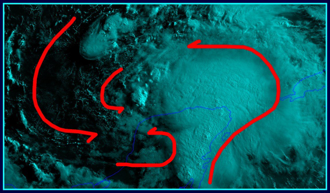
The high cirrus clouds are streaming a little more slowly in the familiar concentric pattern that often indicates higher pressure might be developing mid gulf. Most of the trough circulation is likely still WNW of the shear induced convection.
1 likes
-
Haris

- Category 5

- Posts: 1814
- Joined: Mon Nov 27, 2017 8:19 pm
- Location: ( Bee Cave) West Austin, Texas
Re: NW Carib Flare-Up
the fact nam is going to icon and their entire camp makes me soo anxious ! model war !!!!
1 likes
Weather geek and a storm spotter in West Austin. Not a degreed meteorologist. Big snow fan. Love rain and cold! Despise heat!
Who is online
Users browsing this forum: mixedDanilo.E and 137 guests