NATL: IMELDA - Models

Moderator: S2k Moderators

Message
Author
LarryWx
S2K Supporter
S2K Supporter
Posts: 6830
Joined: Sun Sep 07, 2003 2:04 pm
Location: GA

Re: NATL: INVEST 94L - Models

#81 Postby LarryWx » Thu Sep 25, 2025 12:17 am

BobHarlem wrote:0z canadian shifted left to a Myrtle Beach, SC landfall (was out to sea at 12z)
https://i.imgur.com/Y7qbWfX.png

0z gfs
https://i.postimg.cc/rFc2bg4P/floop-gfs-2025092500-850hv-watl.gif


Humberto dragging 94L away on the 0Z GFS makes sense since Humberto is 25 mb stronger.
1 likes   
Personal Forecast Disclaimer:
The posts in this forum are NOT official forecasts and should not be used as such. They are just the opinion of the poster and may or may not be backed by sound meteorological data. They are NOT endorsed by any professional institution or storm2k.org. For official information, please refer to the NHC and NWS products.

LarryWx
S2K Supporter
S2K Supporter
Posts: 6830
Joined: Sun Sep 07, 2003 2:04 pm
Location: GA

Re: NATL: INVEST 94L - Models

#82 Postby LarryWx » Thu Sep 25, 2025 12:43 am

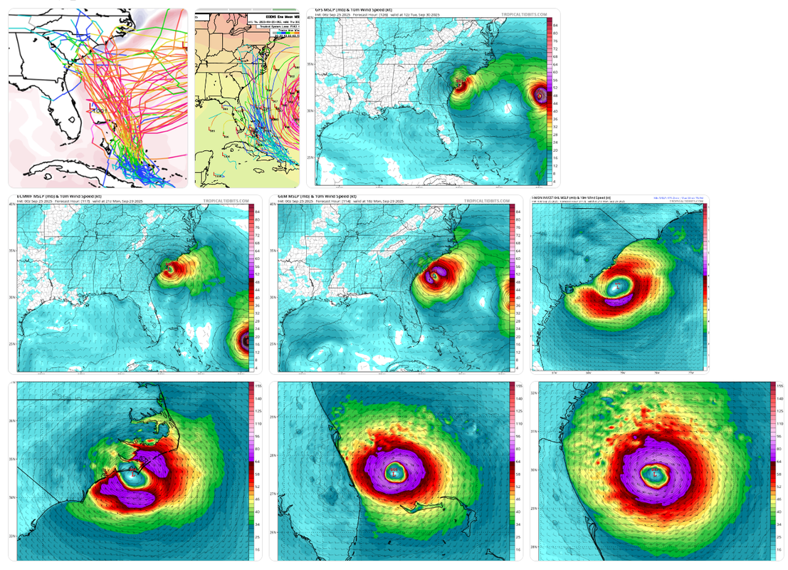
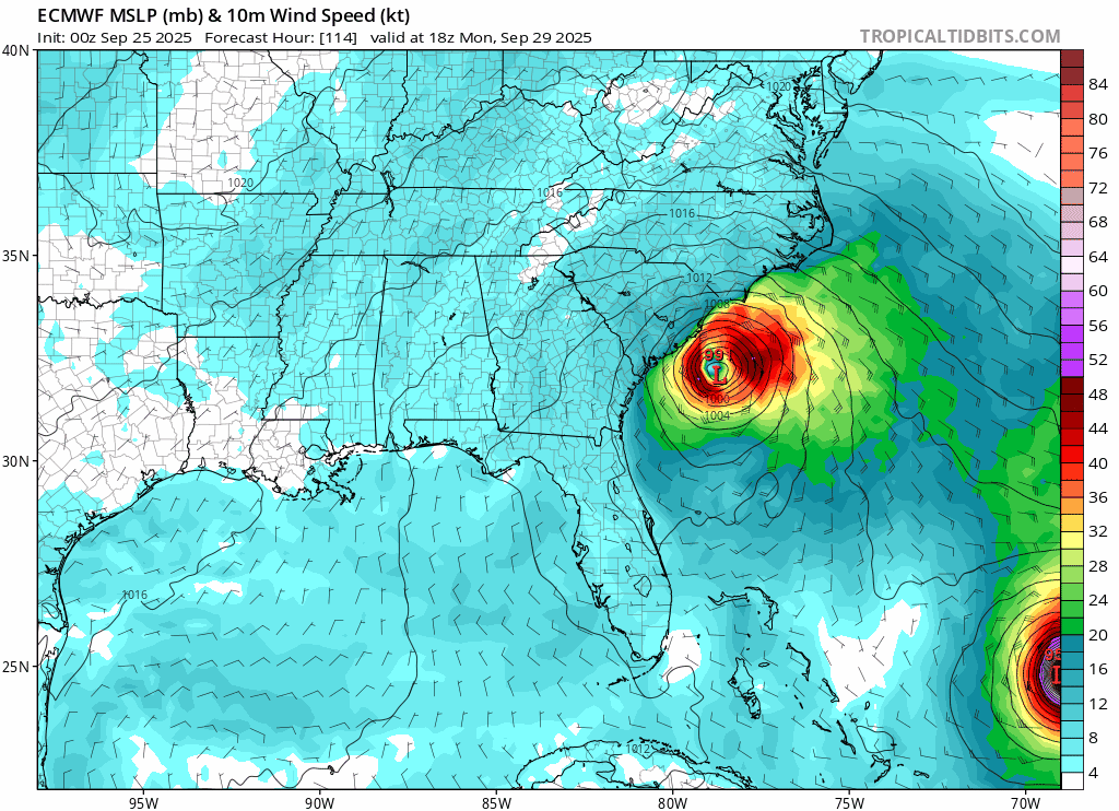
0Z Euro, just like the 0Z CMC, hits Georgetown, SC, on Monday evening though it isn’t as strong (989 mb per WxBell).

So, of major 0Z ops, Euro and CMC hit Georgetown while UKMET, GFS, and Icon stay well offshore.
0 likes   
Personal Forecast Disclaimer:
The posts in this forum are NOT official forecasts and should not be used as such. They are just the opinion of the poster and may or may not be backed by sound meteorological data. They are NOT endorsed by any professional institution or storm2k.org. For official information, please refer to the NHC and NWS products.

Stratton23
Category 5
Category 5
Posts: 2827
Joined: Fri Jul 21, 2023 10:59 pm
Location: Katy, Tx

Re: NATL: INVEST 94L - Models

#83 Postby Stratton23 » Thu Sep 25, 2025 1:24 am

EPS has some pretty bizarre solutions for 94L lol
0 likes   

LarryWx
S2K Supporter
S2K Supporter
Posts: 6830
Joined: Sun Sep 07, 2003 2:04 pm
Location: GA

Re: NATL: INVEST 94L - Models

#84 Postby LarryWx » Thu Sep 25, 2025 1:42 am

Stratton23 wrote:EPS has some pretty bizarre solutions for 94L lol


The 0Z EPS is by far the most ominous for the SE US (including some that get into the Gulf) with a whopping ~75% of the members hitting or skimming. Some of these are very weak (not full TCs) while ~1/3 of the hits are strong.
0 likes   
Personal Forecast Disclaimer:
The posts in this forum are NOT official forecasts and should not be used as such. They are just the opinion of the poster and may or may not be backed by sound meteorological data. They are NOT endorsed by any professional institution or storm2k.org. For official information, please refer to the NHC and NWS products.

User avatar
weeniepatrol
Category 5
Category 5
Posts: 1322
Joined: Sat Aug 22, 2020 5:30 pm
Location: WA State

Re: NATL: INVEST 94L - Models

#85 Postby weeniepatrol » Thu Sep 25, 2025 1:55 am

0z euro not only landfalls this into the carolinas but it also deepens Humberto to 935mb or so

I hereby declare the season cancel to be canceled.
6 likes   

User avatar
kevin
Category 5
Category 5
Posts: 2795
Age: 27
Joined: Wed Aug 28, 2019 4:35 am

Re: NATL: INVEST 94L - Models

#86 Postby kevin » Thu Sep 25, 2025 3:50 am

All 00z hurricane models develop 94L and make it a hurricane (even a MH with the exception of HMON) which threatens the US in the 4 - 7 day range. Humberto might have a higher peak, but 94L might steal the attention as a potential US threat. And of course it'll get the I-name if it develops.

HWRF
Image

HMON
Image

HAFS-B
Image

HAFS-A
Image
4 likes   

User avatar
kevin
Category 5
Category 5
Posts: 2795
Age: 27
Joined: Wed Aug 28, 2019 4:35 am

Re: NATL: INVEST 94L - Models

#87 Postby kevin » Thu Sep 25, 2025 4:20 am

06z ICON has Humberto a bit more to the east than 00z, but not enough to prevent significant shear on 94L. 94L will most likely still become a hurricane if the run would continue (similar to 00z), but would also get pulled away from the US together with Humberto. Note that most hurricane models already have 94L at MH intensity and even almost at the US coast at this time frame in which case the impact of Humberto would be significantly less. So it all depends on how fast 94L moves and organizes.

Image
1 likes   

User avatar
kevin
Category 5
Category 5
Posts: 2795
Age: 27
Joined: Wed Aug 28, 2019 4:35 am

Re: NATL: INVEST 94L - Models

#88 Postby kevin » Thu Sep 25, 2025 4:31 am

06z intensity and track guidance. Ranges from a weak TS clearly OTS (AVNI) to a cat 5 over the Bahamas and on a collision course with the US (HFAI aka HAFS-A). Let's take a latter with a grain of salt for now.

Image

Image
2 likes   

User avatar
ronjon
Category 5
Category 5
Posts: 4881
Joined: Fri Aug 19, 2005 5:17 pm
Location: Hernando Beach, FL

Re: NATL: INVEST 94L - Models

#89 Postby ronjon » Thu Sep 25, 2025 4:45 am

HAFS-A develops 94l into a CAT 5 that threatens SE FL. Fortunately it's the furthest west of the guidance models. Very complex situation but Euro ensembles shift west is disturbing.
1 likes   

User avatar
kevin
Category 5
Category 5
Posts: 2795
Age: 27
Joined: Wed Aug 28, 2019 4:35 am

Re: NATL: INVEST 94L - Models

#90 Postby kevin » Thu Sep 25, 2025 5:09 am

06z GFS also shifts west. Less impact from Humberto, cat 1 landfall near Charleston, SC.

Image
0 likes   

User avatar
GCANE
S2K Supporter
S2K Supporter
Posts: 11864
Joined: Mon Oct 22, 2007 8:03 am

Re: NATL: INVEST 94L - Models

#91 Postby GCANE » Thu Sep 25, 2025 5:19 am

Looks like 06Z GFS has correctly initialized this. A rare occurrence.
Almost all models now have a Charleston-area landfall.
3 likes   

TomballEd
Category 5
Category 5
Posts: 1062
Age: 61
Joined: Wed Aug 16, 2023 4:52 pm
Location: Spring/Klein area, not Tomball

Re: NATL: INVEST 94L - Models

#92 Postby TomballEd » Thu Sep 25, 2025 5:34 am

2 likes   

User avatar
blp
Category 5
Category 5
Posts: 2876
Age: 46
Joined: Thu Sep 09, 2004 7:51 pm
Location: Miami, FL
Contact:

Re: NATL: INVEST 94L - Models

#93 Postby blp » Thu Sep 25, 2025 6:06 am

ronjon wrote:HAFS-A develops 94l into a CAT 5 that threatens SE FL. Fortunately it's the furthest west of the guidance models. Very complex situation but Euro ensembles shift west is disturbing.


Another view of that run. That is some ramp up. :eek:

Image
3 likes   
The following post is NOT an official forecast and should not be used as such. It is just the opinion of the poster and may or may not be backed by sound meteorological data. It is NOT endorsed by any professional institution including storm2k.org For Official Information please refer to the NHC and NWS products.

BobHarlem
Category 5
Category 5
Posts: 2535
Joined: Thu Oct 20, 2005 6:11 pm

Re: NATL: INVEST 94L - Models

#94 Postby BobHarlem » Thu Sep 25, 2025 6:26 am

A bunch o' models:
Image
top to bottom, l t or
0z Google AI, 0z Google Ensembles, 6z GFS,
0z Euro, 0z Canadian, 0z HWRF
0z HMON, 0z HAFS-A, 0z HAFS B
5 likes   

BobHarlem
Category 5
Category 5
Posts: 2535
Joined: Thu Oct 20, 2005 6:11 pm

Re: NATL: INVEST 94L - Models

#95 Postby BobHarlem » Thu Sep 25, 2025 7:07 am

Longer range the GFS pulls the remnants back out into the Atlantic. The Euro also does, redevelops it then makes another landfall in the Outer Banks.

ex 12z Euro
landfall, then comes back out with a second landfall on the OBX.
Image
4 likes   

User avatar
Teban54
Category 5
Category 5
Posts: 3571
Joined: Sat May 19, 2018 1:19 pm

Re: NATL: INVEST 94L - Models

#96 Postby Teban54 » Thu Sep 25, 2025 8:36 am

BobHarlem wrote:Longer range the GFS pulls the remnants back out into the Atlantic. The Euro also does, redevelops it then makes another landfall in the Outer Banks.

ex 12z Euro
landfall, then comes back out with a second landfall on the OBX.
https://i.postimg.cc/fT4dRzkP/ecmwf-mslp-wind-seus-fh114-324.gif

This will surpass Ivan as the most confusing regeneration if it happens.
1 likes   

User avatar
Teban54
Category 5
Category 5
Posts: 3571
Joined: Sat May 19, 2018 1:19 pm

Re: NATL: INVEST 94L - Models

#97 Postby Teban54 » Thu Sep 25, 2025 8:47 am

ICON is now practically the only model with a Fujiwhara and without a CONUS landfall, it seems.
0 likes   

User avatar
boca
Category 5
Category 5
Posts: 6398
Age: 61
Joined: Mon Dec 15, 2003 8:49 am
Location: Boca Raton,FL

Re: NATL: INVEST 94L - Models

#98 Postby boca » Thu Sep 25, 2025 8:49 am

SE Florida is looking better even though we were never a threat from 94L hopefully it will stay on the weaker side for those in the Carolina’s.
0 likes   

BobHarlem
Category 5
Category 5
Posts: 2535
Joined: Thu Oct 20, 2005 6:11 pm

Re: NATL: INVEST 94L - Models

#99 Postby BobHarlem » Thu Sep 25, 2025 8:56 am

This init point

[Image

vs this

Image

I do see the low level swirl there, but the MLC is going bonkers south of Hispaniola.
0 likes   

User avatar
Teban54
Category 5
Category 5
Posts: 3571
Joined: Sat May 19, 2018 1:19 pm

Re: NATL: INVEST 94L - Models

#100 Postby Teban54 » Thu Sep 25, 2025 8:59 am

BobHarlem wrote:This init point

[https://i.imgur.com/Fjg9qzc.png

vs this

https://i.postimg.cc/KzPj6jSs/20392897.gif

I do see the low level swirl there, but the MLC is going bonkers south of Hispaniola.

The init point actually seems fairly close to the low-level vort, which you can see north of DR. The key question is whether it reforms further south... Which can and do happen sometimes, but not always.
0 likes   


Return to “2025”

Who is online

Users browsing this forum: No registered users and 58 guests