Trade winds throughout the Caribbean are stronger than normal according to Phil K. This could mean less intense hurricanes this season.
https://twitter.com/philklotzbach/status/750726852331704321
Seasonal Indicators (Beyond Day 16): Instability / SST's / MSLP / Steering / Sal
Moderator: S2k Moderators
Forum rules

The posts in this forum are NOT official forecasts and should not be used as such. They are just the opinion of the poster and may or may not be backed by sound meteorological data. They are NOT endorsed by any professional institution or STORM2K. For official information, please refer to products from the National Hurricane Center and National Weather Service.
-
TheStormExpert
Re: Seasonal Indicators (Beyond Day 15): Instability / SST's / MSLP / Steering / Sal
Last edited by TheStormExpert on Wed Jul 06, 2016 1:34 pm, edited 1 time in total.
0 likes
-
SFLcane

- S2K Supporter

- Posts: 10281
- Age: 48
- Joined: Sat Jun 05, 2010 1:44 pm
- Location: Lake Worth Florida
Re: Seasonal Indicators (Beyond Day 15): Instability / SST's / MSLP / Steering / Sal
57 if your around can you comment on the 500mb set up and your thoughts on we're you think highest areas at risk are. Haven't heard much from you in terms of all important steering pattern. Thx
0 likes
-
gatorcane

- S2K Supporter
- Posts: 23708
- Age: 48
- Joined: Sun Mar 13, 2005 3:54 pm
- Location: Boca Raton, FL
Re: Seasonal Indicators (Beyond Day 15): Instability / SST's / MSLP / Steering / Sal
No idea if this is an indicator, but the Atlantic continues to be "bone dry" looking at the wide area SAT image. I understand July is usually a dry month in the Atlantic basin but this seems pretty extreme. Here in South Florida we have 0% rain chances for several consecutive days in the RAINY season and heat advisories as a strong SAL surge has moved in from the east. I don't remember it being like this years ago. Seems like it is just getting hotter and drier each summer.

Last edited by gatorcane on Wed Jul 06, 2016 12:05 pm, edited 2 times in total.
0 likes
-
1900hurricane

- Category 5

- Posts: 6063
- Age: 34
- Joined: Fri Feb 06, 2015 12:04 pm
- Location: Houston, TX
- Contact:
Re: Seasonal Indicators (Beyond Day 15): Instability / SST's / MSLP / Steering / Sal
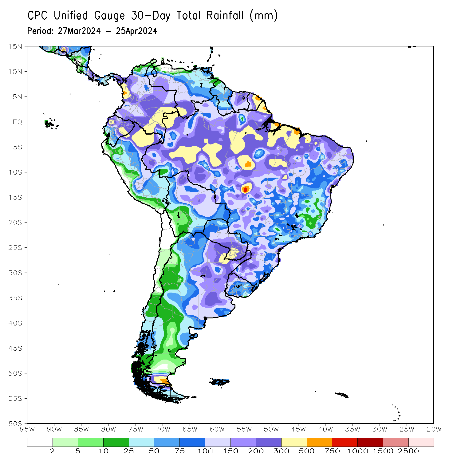
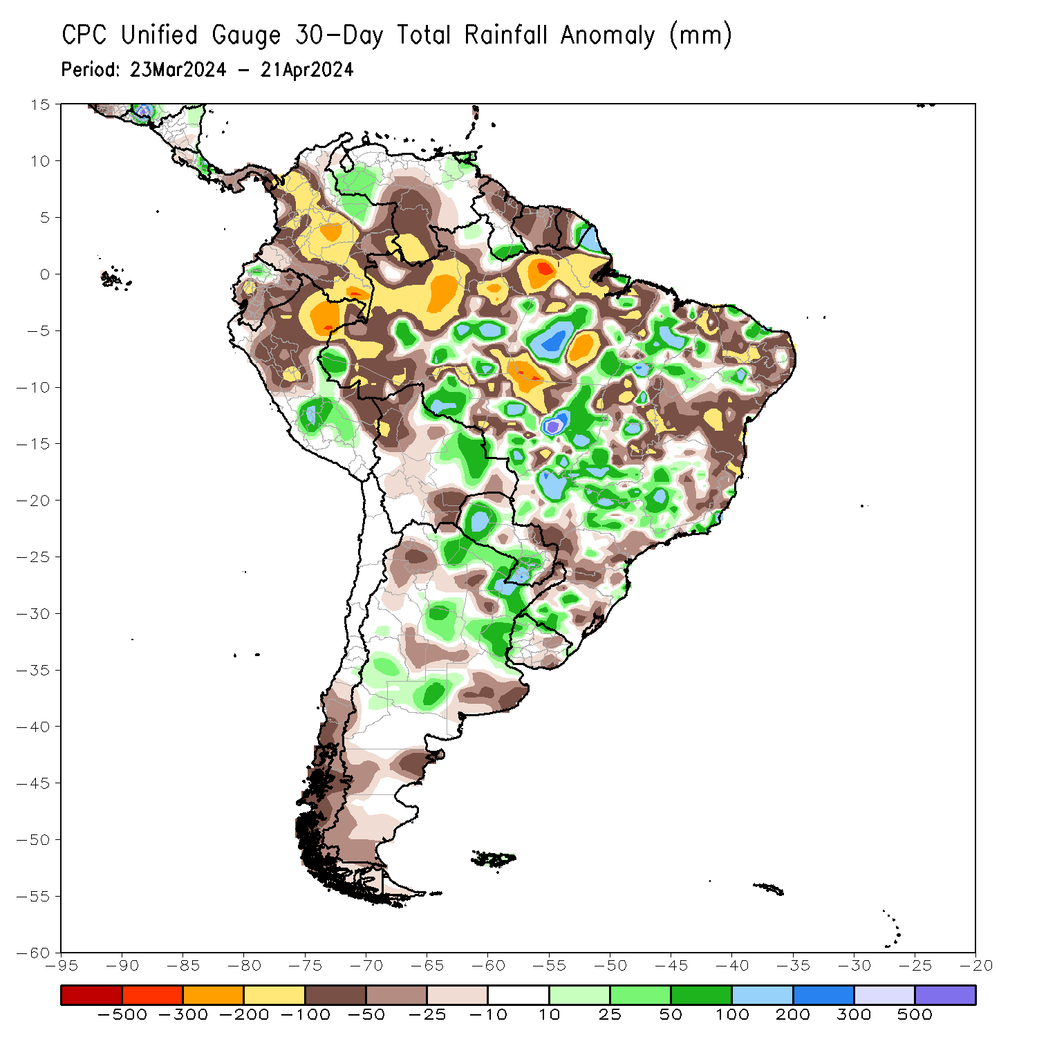
1900hurricane wrote:I'm not sure if this will impact the season or not, but South American drought is very bad right now. I can't remember if I saw someone trying to say that South American drought helped contribute to the 2013 flop (didn't see a mention on a quick scan of the Wiki page for what it's worth).
http://earthobservatory.nasa.gov/IOTD/view.php?id=88308&src=ve
1900hurricane wrote:To be fair, I don't remember where I read such a thing. It may end up having no correlation at all if it was mere speculation or if it was from an unreliable source.
I managed to find one such source, a blog from Dr. Jeff Masters in late 2013. However, it's only one sentence long and contains no outside sources referenced. Even though it's from Dr. Jeff Masters, any correlation still remains somewhat dubious.
https://www.wunderground.com/blog/JeffMasters/comment.html?entrynum=2590
Last edited by 1900hurricane on Wed Jul 06, 2016 12:06 pm, edited 1 time in total.
0 likes
Contract Meteorologist. TAMU & MSST. Fiercely authentic, one of a kind. We are all given free will, so choose a life meant to be lived. We are the Masters of our own Stories.
Opinions expressed are mine alone.
Follow me on Twitter at @1900hurricane : Read blogs at https://1900hurricane.wordpress.com/
Opinions expressed are mine alone.
Follow me on Twitter at @1900hurricane : Read blogs at https://1900hurricane.wordpress.com/
-
tarheelprogrammer

- S2K Supporter
- Posts: 1793
- Joined: Mon Mar 28, 2016 9:25 pm
- Location: Raleigh, NC area (Garner, NC)
Re: Seasonal Indicators (Beyond Day 15): Instability / SST's / MSLP / Steering / Sal
gatorcane wrote:No idea if this is an indicator, but the Atlantic continues to be "bone dry" looking at the wide area SAT image. I understand July is usually a dry month in the Atlantic basin but this seems pretty extreme. Here in South Florida we have 0% rain chances and heat advisories as a strong SAL surge has moved in from the east.
Yeah it is absolutely dry in the Atlantic. Haven't seen it this convection free since the winter and that is saying something.
0 likes
My posts are not official forecasts. They are just my opinion and may or may not be backed by sound meteorological data. They are NOT endorsed by any professional institution or storm2k.org. For official information, please refer to the NHC and NWS products.
-
USTropics
- Professional-Met

- Posts: 2738
- Joined: Sun Aug 12, 2007 3:45 am
- Location: Florida State University
Re: Seasonal Indicators (Beyond Day 15): Instability / SST's / MSLP / Steering / Sal
1900hurricane wrote:1900hurricane wrote:I'm not sure if this will impact the season or not, but South American drought is very bad right now. I can't remember if I saw someone trying to say that South American drought helped contribute to the 2013 flop (didn't see a mention on a quick scan of the Wiki page for what it's worth).
http://earthobservatory.nasa.gov/IOTD/view.php?id=88308&src=ve1900hurricane wrote:To be fair, I don't remember where I read such a thing. It may end up having no correlation at all if it was mere speculation or if it was from an unreliable source.
I managed to find one such source, a blog from Dr. Jeff Masters in late 2013. However, it's only one sentence long and contains no outside sources referenced. Even though it's from Dr. Jeff Masters, any correlation still remains somewhat dubious.
https://www.wunderground.com/blog/JeffMasters/comment.html?entrynum=2590
You're 100% correct. One of Jeff Master's guest bloggers did an indepth article that detailed the Northeast Brazilian drought and its negative impact on the 2013 Atlantic season but I can't find the link. Needless to say, it pretty much stripped the convection off of t-waves as they approached the Caribbean.
Also worth noting that northeast Brazil had a decent rainfall amount during their Autumn season (Autumn in Brazil runs from May-June), giving temporary relief for now. Typically you would see a wet Winter in northeast Brazil during a La Nina as well, but since we don't have a fully developed La Nina yet, that most likely won't happen.
It will bring relief to drought conditions in Colombia and Venezuela, however.
1 likes
-
WPBWeather

- S2K Supporter
- Posts: 535
- Age: 67
- Joined: Thu Jul 18, 2013 12:33 pm
Re: Seasonal Indicators (Beyond Day 15): Instability / SST's / MSLP / Steering / Sal
USTropics wrote:1900hurricane wrote:1900hurricane wrote:I'm not sure if this will impact the season or not, but South American drought is very bad right now. I can't remember if I saw someone trying to say that South American drought helped contribute to the 2013 flop (didn't see a mention on a quick scan of the Wiki page for what it's worth).
http://earthobservatory.nasa.gov/IOTD/view.php?id=88308&src=ve1900hurricane wrote:To be fair, I don't remember where I read such a thing. It may end up having no correlation at all if it was mere speculation or if it was from an unreliable source.
I managed to find one such source, a blog from Dr. Jeff Masters in late 2013. However, it's only one sentence long and contains no outside sources referenced. Even though it's from Dr. Jeff Masters, any correlation still remains somewhat dubious.
https://www.wunderground.com/blog/JeffMasters/comment.html?entrynum=2590
You're 100% correct. One of Jeff Master's guest bloggers did an indepth article that detailed the Northeast Brazilian drought and its negative impact on the 2013 Atlantic season but I can't find the link. Needless to say, it pretty much stripped the convection off of t-waves as they approached the Caribbean.
Also worth noting that northeast Brazil had a decent rainfall amount during their Autumn season (Autumn in Brazil runs from May-June), giving temporary relief for now. Typically you would see a wet Winter in northeast Brazil during a La Nina as well, but since we don't have a fully developed La Nina yet, that most likely won't happen.
It will bring relief to drought conditions in Colombia and Venezuela, however.
Not to beat this to death, but I think some are grasping at straws about the season. No accepted science says anything one way or another.
0 likes

Re: Seasonal Indicators (Beyond Day 15): Instability / SST's / MSLP / Steering / Sal
WPBWeather wrote:USTropics wrote:1900hurricane wrote:
I managed to find one such source, a blog from Dr. Jeff Masters in late 2013. However, it's only one sentence long and contains no outside sources referenced. Even though it's from Dr. Jeff Masters, any correlation still remains somewhat dubious.
https://www.wunderground.com/blog/JeffMasters/comment.html?entrynum=2590
You're 100% correct. One of Jeff Master's guest bloggers did an indepth article that detailed the Northeast Brazilian drought and its negative impact on the 2013 Atlantic season but I can't find the link. Needless to say, it pretty much stripped the convection off of t-waves as they approached the Caribbean.
Also worth noting that northeast Brazil had a decent rainfall amount during their Autumn season (Autumn in Brazil runs from May-June), giving temporary relief for now. Typically you would see a wet Winter in northeast Brazil during a La Nina as well, but since we don't have a fully developed La Nina yet, that most likely won't happen.
It will bring relief to drought conditions in Colombia and Venezuela, however.
Not to beat this to death, but I think some are grasping at straws about the season. No accepted science says anything one way or another.
I can't find any of the articles but I recall reading something like this, but it was the other way around, that one of the contributing factors to the drought was the dry air present in the tropics in the first place--the drought was worsened by the same conditions that helped suppress the season. That being said, despite the ongoing drought, the Atlantic/Caribbean have been much more unstable the last few years (and especially this year) than they were in 2013 so I don't think the drought will in any way be a factor against the season.
0 likes
The above post is not official and should not be used as such. It is the opinion of the poster and may or may not be backed by sound meteorological data. It is not endorsed by any professional institution or storm2k.org. For official information, please refer to the NHC and NWS products.
-
Hurricaneman

- Category 5
- Posts: 7404
- Age: 45
- Joined: Tue Aug 31, 2004 3:24 pm
- Location: central florida
Re: Seasonal Indicators (Beyond Day 15): Instability / SST's / MSLP / Steering / Sal
Looking at things the MJO is modeled to become more favorable the last 10 days of the month through the first half of August but thats the Euro input, the GFS input doesn't really go into a favorable MJO, I'm more likely to go with the Euro as the MJO seems to be following that model better than the GFS
The posts in this forum are NOT official forecast and should not be used as such. They are just the opinion of the poster and may or may not be backed by sound meteorological data. They are NOT endorsed by any professional institution or STORM2K. For official information, please refer to products from the National Hurricane Center and National Weather Service
The posts in this forum are NOT official forecast and should not be used as such. They are just the opinion of the poster and may or may not be backed by sound meteorological data. They are NOT endorsed by any professional institution or STORM2K. For official information, please refer to products from the National Hurricane Center and National Weather Service
0 likes
-
ninel conde
Re: Seasonal Indicators (Beyond Day 15): Instability / SST's / MSLP / Steering / Sal
gatorcane wrote:No idea if this is an indicator, but the Atlantic continues to be "bone dry" looking at the wide area SAT image. I understand July is usually a dry month in the Atlantic basin but this seems pretty extreme. Here in South Florida we have 0% rain chances for several consecutive days in the RAINY season and heat advisories as a strong SAL surge has moved in from the east. I don't remember it being like this years ago. Seems like it is just getting hotter and drier each summer.

Its easy to see why the atlantic is bone dry. pressures well above normal and the high is perfectly positioned to flood the atlantic with cane killing dust. its also why trade winds are way above normal with the high pushed well south because of the neg NAO. I really dont know why some are saying the conditions are going to change.
0 likes
-
Hurricaneman
- Category 5
- Posts: 7404
- Age: 45
- Joined: Tue Aug 31, 2004 3:24 pm
- Location: central florida
Re: Seasonal Indicators (Beyond Day 15): Instability / SST's / MSLP / Steering / Sal
ninel conde wrote:gatorcane wrote:No idea if this is an indicator, but the Atlantic continues to be "bone dry" looking at the wide area SAT image. I understand July is usually a dry month in the Atlantic basin but this seems pretty extreme. Here in South Florida we have 0% rain chances for several consecutive days in the RAINY season and heat advisories as a strong SAL surge has moved in from the east. I don't remember it being like this years ago. Seems like it is just getting hotter and drier each summer.
Its easy to see why the atlantic is bone dry. pressures well above normal and the high is perfectly positioned to flood the atlantic with cane killing dust. its also why trade winds are way above normal with the high pushed well south because of the neg NAO. I really dont know why some are saying the conditions are going to change.
yes dry air is the game in the atlantic right now but looking at the long range models the azores high is going to weaken and retreat north of the Azores which should allow for robust tropical waves and by the way the way the atlantic looks right now is actually quite normal and will probably change in the next 15 to 20 days with climatology
saying that we most likely will have lots more activity soon
ps: The Azore high is at around 40N on the GFS at 240 retreating from 32N which would allow for more moisture in the ITCZ and more favorability while the Euro has the high pressure at 50N which would be quite favorable for something to get going in the MDR
The posts in this forum are NOT official forecast and should not be used as such. They are just the opinion of the poster and may or may not be backed by sound meteorological data. They are NOT endorsed by any professional institution or STORM2K. For official information, please refer to products from the National Hurricane Center and National Weather Service
0 likes

Re: Seasonal Indicators (Beyond Day 15): Instability / SST's / MSLP / Steering / Sal
1900hurricane wrote:I'm not sure if this will impact the season or not, but South American drought is very bad right now. I can't remember if I saw someone trying to say that South American drought helped contribute to the 2013 flop (didn't see a mention on a quick scan of the Wiki page for what it's worth).
http://earthobservatory.nasa.gov/IOTD/view.php?id=88308&src=ve
Is fairly normal for parts of north east S.A. to be in a severe drought during a strong El Nino event. But since El Nino is gone some of this area has seen some relief during the past 30 days.
Regarding 2013, it was the drought in northern Brazil that year that they were trying correlate with the very dry conditions in the atmosphere from the Atlantic MDR down southward.
0 likes
Re: Seasonal Indicators (Beyond Day 15): Instability / SST's / MSLP / Steering / Sal
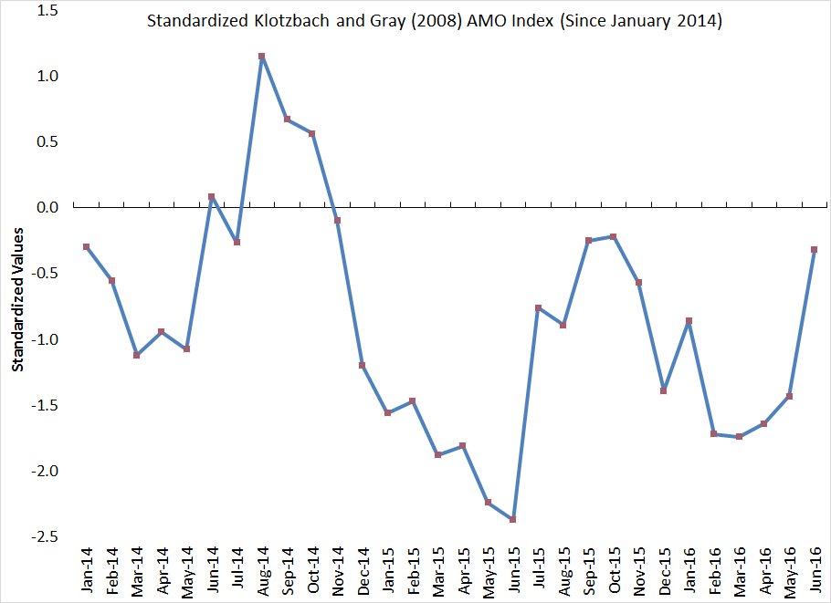
Dr Phil K is too funny, so according to their index the AMO jumped all the way from -1.4 to -0.3 from May to June and he calls it a "somewhat rebound". I call it a "big" rebound, lol. Compared to July of last year it is higher, leading me to believe that if current trends continue it may even go positive during the heart of the hurricane season.
Philip Klotzbach
@philklotzbach
The AMO rebounded somewhat in June to -0.3 standard deviations. It has remained negative for 20 straight months.
0 likes
-
USTropics
- Professional-Met
- Posts: 2738
- Joined: Sun Aug 12, 2007 3:45 am
- Location: Florida State University
Re: Seasonal Indicators (Beyond Day 15): Instability / SST's / MSLP / Steering / Sal
WPBWeather wrote:USTropics wrote:1900hurricane wrote:
I managed to find one such source, a blog from Dr. Jeff Masters in late 2013. However, it's only one sentence long and contains no outside sources referenced. Even though it's from Dr. Jeff Masters, any correlation still remains somewhat dubious.
https://www.wunderground.com/blog/JeffMasters/comment.html?entrynum=2590
You're 100% correct. One of Jeff Master's guest bloggers did an indepth article that detailed the Northeast Brazilian drought and its negative impact on the 2013 Atlantic season but I can't find the link. Needless to say, it pretty much stripped the convection off of t-waves as they approached the Caribbean.
Also worth noting that northeast Brazil had a decent rainfall amount during their Autumn season (Autumn in Brazil runs from May-June), giving temporary relief for now. Typically you would see a wet Winter in northeast Brazil during a La Nina as well, but since we don't have a fully developed La Nina yet, that most likely won't happen.
It will bring relief to drought conditions in Colombia and Venezuela, however.
Not to beat this to death, but I think some are grasping at straws about the season. No accepted science says anything one way or another.
I was only commenting on conditions in 2013, not what will be present this season. Northeast Brazil had a wet Autumn this year, not like in 2013 (which I alluded to). It also wasn't just dry air intrusion from the drought conditions in SA (although it was a factor), but a three pronged attack with a large area of low pressure in the central Atlantic bringing dry, sinking air to the area and a large propagation of SAL.
0 likes
Re: Seasonal Indicators (Beyond Day 15): Instability / SST's / MSLP / Steering / Sal
Hurricaneman wrote:ninel conde wrote:gatorcane wrote:No idea if this is an indicator, but the Atlantic continues to be "bone dry" looking at the wide area SAT image. I understand July is usually a dry month in the Atlantic basin but this seems pretty extreme. Here in South Florida we have 0% rain chances for several consecutive days in the RAINY season and heat advisories as a strong SAL surge has moved in from the east. I don't remember it being like this years ago. Seems like it is just getting hotter and drier each summer.
http://i.imgur.com/74YaQAg.jpg
http://moe.met.fsu.edu/tcgengifs/gfs/2016070612/slp8.png
Its easy to see why the atlantic is bone dry. pressures well above normal and the high is perfectly positioned to flood the atlantic with cane killing dust. its also why trade winds are way above normal with the high pushed well south because of the neg NAO. I really dont know why some are saying the conditions are going to change.
yes dry air is the game in the atlantic right now but looking at the long range models the azores high is going to weaken and retreat north of the Azores which should allow for robust tropical waves and by the way the way the atlantic looks right now is actually quite normal and will probably change in the next 15 to 20 days with climatology
saying that we most likely will have lots more activity soon
ps: The Azore high is at around 40N on the GFS at 240 retreating from 32N which would allow for more moisture in the ITCZ and more favorability while the Euro has the high pressure at 50N which would be quite favorable for something to get going in the MDR
The posts in this forum are NOT official forecast and should not be used as such. They are just the opinion of the poster and may or may not be backed by sound meteorological data. They are NOT endorsed by any professional institution or STORM2K. For official information, please refer to products from the National Hurricane Center and National Weather Service
The similarities to 1998 continue to be remarkable. El Nino exiting, drought in the southeast, repeated troughs coming off the Mid-Atlantic and Northeast coast, and large dry swath across most of the Atlantic.
http://i.imgur.com/v420fqU.jpg today (there is more convection than the visible image leads one to believe.)
http://i.imgur.com/tIxtHRh.png 7/18/98: very similar appearance to now, and this was later in the month even. And Florida went most of June and though a large chunk of July with little to no rainfall.
But 1999-2001 also had long dry periods during July.
http://i.imgur.com/5UeVezj.png July 25 1999
http://i.imgur.com/sOx1Upt.png July 24 2000
http://i.imgur.com/Wirr1xy.png July 19 2001 (later in the month and the western section of the ITCZ was all but nonexistent.)
All three largely mirror this season: some ITCZ convection, convection north of the Caribbean, east coast trough, and basically nothing in the Caribbean or GoM.
In fact there was one depression in July, in the BoC, that formed as it was moving inland during those three years. A barren July in the Atlantic is no indicator of the rest of the season, and if anything the convection is higher overall so far this year during July than it's been since 2012.
1 likes
The above post is not official and should not be used as such. It is the opinion of the poster and may or may not be backed by sound meteorological data. It is not endorsed by any professional institution or storm2k.org. For official information, please refer to the NHC and NWS products.
-
ninel conde
Re: Seasonal Indicators (Beyond Day 15): Instability / SST's / MSLP / Steering / Sal
Hurricaneman wrote:ninel conde wrote:gatorcane wrote:No idea if this is an indicator, but the Atlantic continues to be "bone dry" looking at the wide area SAT image. I understand July is usually a dry month in the Atlantic basin but this seems pretty extreme. Here in South Florida we have 0% rain chances for several consecutive days in the RAINY season and heat advisories as a strong SAL surge has moved in from the east. I don't remember it being like this years ago. Seems like it is just getting hotter and drier each summer.
Its easy to see why the atlantic is bone dry. pressures well above normal and the high is perfectly positioned to flood the atlantic with cane killing dust. its also why trade winds are way above normal with the high pushed well south because of the neg NAO. I really dont know why some are saying the conditions are going to change.
yes dry air is the game in the atlantic right now but looking at the long range models the azores high is going to weaken and retreat north of the Azores which should allow for robust tropical waves and by the way the way the atlantic looks right now is actually quite normal and will probably change in the next 15 to 20 days with climatology
saying that we most likely will have lots more activity soon
ps: The Azore high is at around 40N on the GFS at 240 retreating from 32N which would allow for more moisture in the ITCZ and more favorability while the Euro has the high pressure at 50N which would be quite favorable for something to get going in the MDR
The posts in this forum are NOT official forecast and should not be used as such. They are just the opinion of the poster and may or may not be backed by sound meteorological data. They are NOT endorsed by any professional institution or STORM2K. For official information, please refer to products from the National Hurricane Center and National Weather Service
I hope that occurs. another ray of hope is dan leonard saying the heat ridge over the southern US will expand north which hopefully will cut off the flood pattern and WNW flow.
0 likes
Re: Seasonal Indicators (Beyond Day 15): Instability / SST's / MSLP / Steering / Sal
ninel conde wrote:I hope that occurs. another ray of hope is dan leonard saying the heat ridge over the southern US will expand north which hopefully will cut off the flood pattern and WNW flow.
I'm hoping it pulls out altogether--we're certainly in desperate need of rain here in northern Georgia.
0 likes
The above post is not official and should not be used as such. It is the opinion of the poster and may or may not be backed by sound meteorological data. It is not endorsed by any professional institution or storm2k.org. For official information, please refer to the NHC and NWS products.
-
ninel conde
Re: Seasonal Indicators (Beyond Day 15): Instability / SST's / MSLP / Steering / Sal
Hammy wrote:ninel conde wrote:I hope that occurs. another ray of hope is dan leonard saying the heat ridge over the southern US will expand north which hopefully will cut off the flood pattern and WNW flow.
I'm hoping it pulls out altogether--we're certainly in desperate need of rain here in northern Georgia.
Wish you could get all our rain. wooden porch covered in mold. had to spray it with bleach.
0 likes
-
tolakram
- Admin

- Posts: 20185
- Age: 62
- Joined: Sun Aug 27, 2006 8:23 pm
- Location: Florence, KY (name is Mark)
Re: Seasonal Indicators (Beyond Day 15): Instability / SST's / MSLP / Steering / Sal
For anyone interested, older satellite imagery is archived and available here: http://www.ncdc.noaa.gov/gibbs/
Pretty neat archive, and if you let the images load for each frame you can smoothly animate every 3 hours.
Pretty neat archive, and if you let the images load for each frame you can smoothly animate every 3 hours.
2 likes
M a r k
- - - - -
Join us in chat: Storm2K Chatroom Invite. Android and IOS apps also available.
The posts in this forum are NOT official forecasts and should not be used as such. Posts are NOT endorsed by any professional institution or STORM2K.org. For official information and forecasts, please refer to NHC and NWS products.
-
Hurricaneman
- Category 5
- Posts: 7404
- Age: 45
- Joined: Tue Aug 31, 2004 3:24 pm
- Location: central florida
Re: Seasonal Indicators (Beyond Day 15): Instability / SST's / MSLP / Steering / Sal
I look at 1998 and what I see for the most part is a dusty dry atlantic until mid August and things changed just like that to an active regime in the MDR which included such storms as Bonnie, Danielle, Georges, Ivan, Jeanne into late September so in that time between August19 to September 25 there were 5 storms that formed in the MDR so if this year is anything like 1998 we could get 1 month of craziness starting next month or if the models are right could be even late this month
The posts in this forum are NOT official forecast and should not be used as such. They are just the opinion of the poster and may or may not be backed by sound meteorological data. They are NOT endorsed by any professional institution or STORM2K. For official information, please refer to products from the National Hurricane Center and National Weather Service
The posts in this forum are NOT official forecast and should not be used as such. They are just the opinion of the poster and may or may not be backed by sound meteorological data. They are NOT endorsed by any professional institution or STORM2K. For official information, please refer to products from the National Hurricane Center and National Weather Service
1 likes
Who is online
Users browsing this forum: NotSparta and 153 guests