NATL: MELISSA - Aftermath - Discussion
Moderator: S2k Moderators
Re: NATL: MELISSA - Hurricane - Discussion
Looks like the plane is heading in for another pass soon. NE to SW. We’ll see if the intensification is continuing (it likely is).
2 likes
-
Keldeo1997
- Category 2

- Posts: 688
- Joined: Fri Oct 11, 2019 11:35 pm
Re: NATL: MELISSA - Hurricane - Discussion

Oh noooooo
Edit: Also how in heck did it get a annular structure?
Last edited by Keldeo1997 on Sat Oct 25, 2025 11:31 pm, edited 1 time in total.
12 likes
-
Iceresistance

- Category 5

- Posts: 9607
- Age: 22
- Joined: Sat Oct 10, 2020 9:45 am
- Location: Tecumseh, OK/Norman, OK
Re: NATL: MELISSA - Hurricane - Discussion
Holy crap I have never seen anything like this before
Super thick eyewall with no banding
Removed image since it was the same, whoops
Last edited by Iceresistance on Sat Oct 25, 2025 11:39 pm, edited 3 times in total.
4 likes
Bill 2015 & Beta 2020
Winter 2020-2021
All observations are in Tecumseh, OK unless otherwise noted.
Winter posts are focused mainly for Oklahoma & Texas.
Take any of my forecasts with a grain of salt, refer to the NWS, SPC, and NHC for official information
Never say Never with weather! Because ANYTHING is possible!
Winter 2020-2021
All observations are in Tecumseh, OK unless otherwise noted.
Winter posts are focused mainly for Oklahoma & Texas.
Take any of my forecasts with a grain of salt, refer to the NWS, SPC, and NHC for official information
Never say Never with weather! Because ANYTHING is possible!

Re: NATL: MELISSA - Hurricane - Discussion
This is a WPAC-level monster
Last edited by edu2703 on Sat Oct 25, 2025 11:36 pm, edited 2 times in total.
5 likes
-
CrazyC83
- Professional-Met

- Posts: 34316
- Joined: Tue Mar 07, 2006 11:57 pm
- Location: Deep South, for the first time!
Re: NATL: MELISSA - Hurricane - Discussion
I'm thinking it finds a pressure around 955 this pass.
5 likes
Re: NATL: MELISSA - Hurricane - Discussion
Both microwave and radar indicate there is a thin rainband just outside of the eyewall (you can see the 2 layers). This kind of structure reminds me of Irma.
1 likes

Re: NATL: MELISSA - Hurricane - Discussion


3 likes
TC naming lists: retirements and intensity
Most aggressive Advisory #1's in North Atlantic (cr. kevin for starting the list)
Most aggressive Advisory #1's in North Atlantic (cr. kevin for starting the list)
-
InfernoFlameCat

- Category 5
- Posts: 2127
- Age: 23
- Joined: Mon Dec 14, 2020 10:52 am
- Location: Buford, GA
Re: NATL: MELISSA - Hurricane - Discussion
Keldeo1997 wrote:https://cdn.discordapp.com/attachments/1157676956674949152/1431861979290800250/IMG_5367.jpeg?ex=68fef4e2&is=68fda362&hm=3b70e929e0ffcf966f74923b7d20b31cc6553698efb3073802b70ebacc79c3b8&
Oh noooooo
Edit: Also how in heck did it get a annular structure?
Absolutely no EWRC anywhere near occurring
2 likes
I am by no means a professional. DO NOT look at my forecasts for official information or make decisions based on what I post.
Goal: to become a registered expert over tropical and subtropical cyclones.
Goal: to become a registered expert over tropical and subtropical cyclones.

Re: NATL: MELISSA - Hurricane - Discussion
Absolutely stunning how fast the eye popped and symmetrization occured.Teban54 wrote::double:
2 likes
-
Tekken_Guy
- Tropical Storm

- Posts: 150
- Joined: Fri Sep 01, 2017 8:08 pm
Re: NATL: MELISSA - Hurricane - Discussion
galaxy401 wrote:Melissa single-handedly making the Caribbean from a graveyard this season to featuring potentially the most intense storm worldwide for the year.
It doesn’t look like it will top Ragasa at this point.
0 likes
Re: NATL: MELISSA - Hurricane - Discussion
It could be close, Melissa has plenty of time still and the SSTs are nonlimiting. However the environment isn't perfect and Jamaica is close enough to maybe put a wrinkle on the inflow. I wouldn't confidently bet either way.Tekken_Guy wrote:galaxy401 wrote:Melissa single-handedly making the Caribbean from a graveyard this season to featuring potentially the most intense storm worldwide for the year.
It doesn’t look like it will top Ragasa at this point.
0 likes

Re: NATL: MELISSA - Hurricane - Discussion
Tekken_Guy wrote:galaxy401 wrote:Melissa single-handedly making the Caribbean from a graveyard this season to featuring potentially the most intense storm worldwide for the year.
It doesn’t look like it will top Ragasa at this point.
Ragasa's official peak was 140 kts / 905 hPa (though admittedly in post-season analysis that intensity may be increased based on buoy obs.). Melissa is forecast to at least match Ragasa's wind speed, and matching its central pressure isn't at all outside the realm of possibility (several GDM ensemble members show such a scenario). We've got a storm with a nearly perfect structure, no signs of an imminent EWRC, and 36 hours before landfall...I wouldn't count her out yet.
7 likes

Re: NATL: MELISSA - Hurricane - Discussion
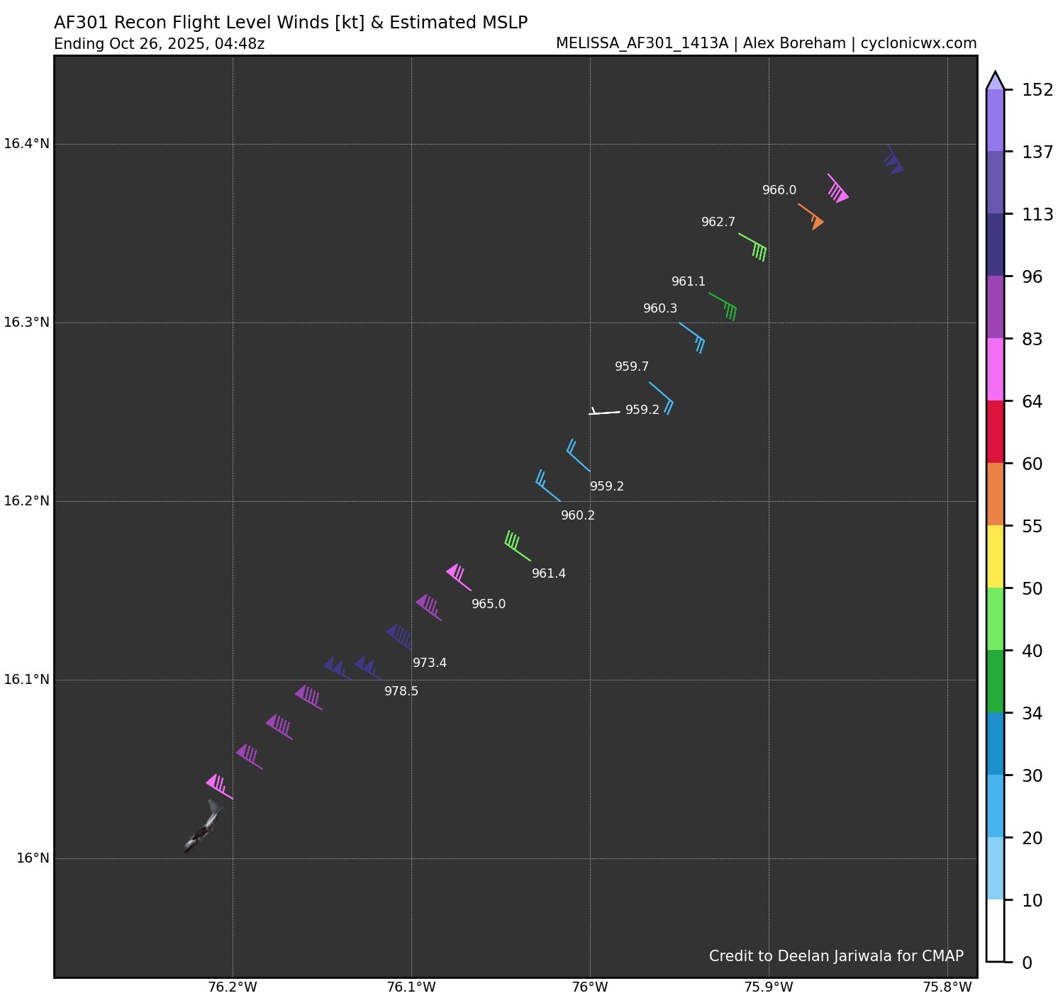
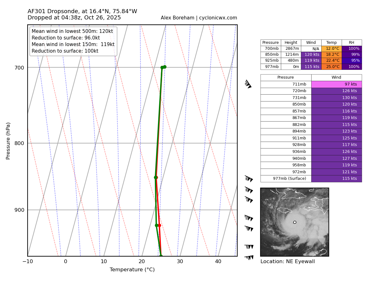
Down to 959.2mb extrap pressure, and 114kt FL winds blend with 104kt SFMR to support 105kts.
5 likes
-
Keldeo1997
- Category 2
- Posts: 688
- Joined: Fri Oct 11, 2019 11:35 pm
Re: NATL: MELISSA - Hurricane - Discussion
Travorum wrote:Down to 959.2mb extrap pressure, and 114kt FL winds blend with 104kt SFMR to support 105kts.
AF301's previous pass had 966.1 mb extrap, and the dropsonade supported ~967 mb. That's roughly a drop of 7 mb in 2.3 hours (3 mb/hr).
3 likes
TC naming lists: retirements and intensity
Most aggressive Advisory #1's in North Atlantic (cr. kevin for starting the list)
Most aggressive Advisory #1's in North Atlantic (cr. kevin for starting the list)
-
Iceresistance
- Category 5
- Posts: 9607
- Age: 22
- Joined: Sat Oct 10, 2020 9:45 am
- Location: Tecumseh, OK/Norman, OK
Re: NATL: MELISSA - Hurricane - Discussion
4 likes
Bill 2015 & Beta 2020
Winter 2020-2021
All observations are in Tecumseh, OK unless otherwise noted.
Winter posts are focused mainly for Oklahoma & Texas.
Take any of my forecasts with a grain of salt, refer to the NWS, SPC, and NHC for official information
Never say Never with weather! Because ANYTHING is possible!
Winter 2020-2021
All observations are in Tecumseh, OK unless otherwise noted.
Winter posts are focused mainly for Oklahoma & Texas.
Take any of my forecasts with a grain of salt, refer to the NWS, SPC, and NHC for official information
Never say Never with weather! Because ANYTHING is possible!
-
CrazyC83
- Professional-Met
- Posts: 34316
- Joined: Tue Mar 07, 2006 11:57 pm
- Location: Deep South, for the first time!
Re: NATL: MELISSA - Hurricane - Discussion
Iceresistance wrote:Instantaneous winds, but wow
https://s12.gifyu.com/images/b3nV7.png
https://s12.gifyu.com/images/b3nV7.png
Eye drop is 959 with 7 knots btw
That drop supports 958 mb - a drop of 9 mb in about 1 1/2 hours.
0 likes
-
Hurricane2022

- Category 5
- Posts: 2092
- Joined: Tue Aug 23, 2022 11:38 pm
- Location: Araçatuba, Brazil
Re: NATL: MELISSA - Hurricane - Discussion
5 likes
Sorry for the bad English sometimes...!
For reliable and detailed information for any meteorological phenomenon, please consult the National Hurricane Center, Joint Typhoon Warning Center , or your local Meteo Center.
--------
ECCE OMNIA NOVA FACIAM (Ap 21,5).
For reliable and detailed information for any meteorological phenomenon, please consult the National Hurricane Center, Joint Typhoon Warning Center , or your local Meteo Center.
--------
ECCE OMNIA NOVA FACIAM (Ap 21,5).
Re: NATL: MELISSA - Hurricane - Discussion
CrazyC83 wrote:Iceresistance wrote:Instantaneous winds, but wow
https://s12.gifyu.com/images/b3nV7.png
https://s12.gifyu.com/images/b3nV7.png
Eye drop is 959 with 7 knots btw
That drop supports 958 mb - a drop of 9 mb in about 1 1/2 hours.
I’m about to head to bed, I really hope that drop rate doesn’t continue for the next seven hours. She’s trying to make her name in the history books.
1 likes
Re: NATL: MELISSA - Hurricane - Discussion
CrazyC83 wrote:Iceresistance wrote:Instantaneous winds, but wow
https://s12.gifyu.com/images/b3nV7.png
https://s12.gifyu.com/images/b3nV7.png
Eye drop is 959 with 7 knots btw
That drop supports 958 mb - a drop of 9 mb in about 1 1/2 hours.
Did I miss something? The most recent eye pass that I could find from either aircraft was at 2:28z, which was 2 1/2 hours ago, not 1 1/2.
Last edited by Teban54 on Sun Oct 26, 2025 12:12 am, edited 1 time in total.
0 likes
TC naming lists: retirements and intensity
Most aggressive Advisory #1's in North Atlantic (cr. kevin for starting the list)
Most aggressive Advisory #1's in North Atlantic (cr. kevin for starting the list)
Who is online
Users browsing this forum: No registered users and 50 guests