ATL: Tropical Depression Fay

Moderator: S2k Moderators

Message
Author
User avatar
x-y-no
Category 5
Category 5
Posts: 8359
Age: 65
Joined: Wed Aug 11, 2004 12:14 pm
Location: Fort Lauderdale, FL

Re: ATL: Tropical Storm Fay in Florida Straits

#8361 Postby x-y-no » Mon Aug 18, 2008 12:03 pm

Clipper96 wrote:
x-y-no wrote:Sombrero Key (Anemometer height: 48.5 m)
...
38 knots sustained.
That is very nice; where are you getting them?


National Data Buoy Center:

http://www.ndbc.noaa.gov/maps/Florida.shtml
0 likes   

User avatar
Extremeweatherguy
Category 5
Category 5
Posts: 11095
Joined: Mon Oct 10, 2005 8:13 pm
Location: Florida

#8362 Postby Extremeweatherguy » Mon Aug 18, 2008 12:04 pm

Winds look to be very slowly increasing in Miami. The Miami International airport has gone from 7mph last hour to 15mph this hour. The first frequent gusts over 20mph should probably be arriving there soon. Down in Homestead, they are already gusting to 25mph.
0 likes   

User avatar
HURAKAN
Professional-Met
Professional-Met
Posts: 46086
Age: 38
Joined: Thu May 20, 2004 4:34 pm
Location: Key West, FL
Contact:

#8363 Postby HURAKAN » Mon Aug 18, 2008 12:05 pm

Image

Looks like its becoming better organized. Fay must have found heaven in the Gulf Stream.
0 likes   

User avatar
Blown Away
S2K Supporter
S2K Supporter
Posts: 10252
Joined: Wed May 26, 2004 6:17 am

Re: ATL: Tropical Storm Fay in Florida Straits

#8364 Postby Blown Away » Mon Aug 18, 2008 12:06 pm

deltadog03 wrote:
EURO has a very potent CANE sitting off the GA coast and coming in on thursday!


Deltadog03, will you confirm a few things:
1. Did recent recon indicate N movement?
2. With regards to the NHC track is this N movement early?
3. Do you expect more of an E adjustment to the NHC track?
4. Do you think Fay will exit into the Atlantic S of the Cape?

Sorry posted in the Fay models also.
Last edited by Blown Away on Mon Aug 18, 2008 12:16 pm, edited 1 time in total.
0 likes   

User avatar
artist
Category 5
Category 5
Posts: 9792
Joined: Mon Jun 06, 2005 3:26 pm
Location: West Palm

Re: Re:

#8365 Postby artist » Mon Aug 18, 2008 12:07 pm

NEXRAD wrote:
wxwonder12 wrote:Is the northward motion happening in the expected time frame or is it earlier then expected


I wouldn't consider a single fix to be a northward motion. Fay's past movement shows plenty of sudden changes with direction (more west versus more north) and with forward motion. I'd wait to see what the trend is over several hours.

- Jay


Jay, we are 30 miles to the east of the lake O. Do you think we will see anything more than ts winds here? Thanks!
0 likes   

User avatar
x-y-no
Category 5
Category 5
Posts: 8359
Age: 65
Joined: Wed Aug 11, 2004 12:14 pm
Location: Fort Lauderdale, FL

Re: ATL: Tropical Storm Fay in Florida Straits

#8366 Postby x-y-no » Mon Aug 18, 2008 12:07 pm

NEXRAD wrote:With the Florida Keys surface observations, notice the steeper pressure drops, this is a clear sign that the locations are falling within the tropical cyclone's core region.

- Jay


Yes - while up at Fowey Rocks (offshore from Miami) it's still just an average day, 17 knot wind, no particular pressure drop.

That'll change soon ...
0 likes   

tolakram
Admin
Admin
Posts: 20165
Age: 62
Joined: Sun Aug 27, 2006 8:23 pm
Location: Florence, KY (name is Mark)

Re: ATL: Tropical Storm Fay in Florida Straits

#8367 Postby tolakram » Mon Aug 18, 2008 12:08 pm

Image

and once again the hi res floater link:

http://hadar.cira.colostate.edu/ramsdis ... ive_0.html
0 likes   

User avatar
Hurricanewatcher2007
Category 2
Category 2
Posts: 578
Joined: Sat Jul 05, 2008 8:10 pm

Re: ATL: Tropical Storm Fay in Florida Straits

#8368 Postby Hurricanewatcher2007 » Mon Aug 18, 2008 12:09 pm

Blown_away wrote:
deltadog03 wrote:
EURO has a very potent CANE sitting off the GA coast and coming in on thursday!


Deltadog03, will you confirm a few things:
1. Did recent recon indicate N movement?
2. With regards to the NHC track is this N movement early?
3. Do you expect more of an E adjustment to the NHC track?
4. Do you think Fay will exit into the Atlantic S of the Cape?

Sorry posted in the Fay models aslo.


I am not deltadog but I have been watching recon closely. According to the last center fix it was north of where the center fix was before that. Could be a sign of a North movement, could be a wobble, could be the center being pulled up by the deeper convection. This next fix will decide if it is a North movement or not and even if it is it could still be just a short term movement.
0 likes   

User avatar
KWT
Category 5
Category 5
Posts: 31416
Joined: Tue Aug 17, 2004 11:02 am
Location: UK!!!

#8369 Postby KWT » Mon Aug 18, 2008 12:09 pm

Looks like its structure is indeed improviung Hurakan but the shearing is really stopping this from doing a great deal in terms of ramping up compared to what is possibly in this region of the basin.
Still depsite the shear the system does seem to be slowly strengthening.
0 likes   

User avatar
StJoe
S2K Supporter
S2K Supporter
Posts: 274
Age: 55
Joined: Wed Sep 01, 2004 11:55 am
Location: Wellington

Re: ATL: Tropical Storm Fay in Florida Straits

#8370 Postby StJoe » Mon Aug 18, 2008 12:10 pm

tolakram wrote:Image

and once again the hi res floater link:

http://hadar.cira.colostate.edu/ramsdis ... ive_0.html


OMG...she is exploding!!! :eek:
0 likes   

User avatar
WhirlWind
Tropical Storm
Tropical Storm
Posts: 104
Age: 66
Joined: Sat Oct 12, 2002 9:04 pm
Location: Lehigh Acres, Florida
Contact:

#8371 Postby WhirlWind » Mon Aug 18, 2008 12:11 pm

Lee County schools have now closed for Tuesday.
WhirlWind
0 likes   

Clipper96

Re: ATL: Tropical Storm Fay in Florida Straits

#8372 Postby Clipper96 » Mon Aug 18, 2008 12:11 pm

NEXRAD wrote:With the Florida Keys surface observations, notice the steeper pressure drops, this is a clear sign that the locations are falling within the tropical cyclone's core region.
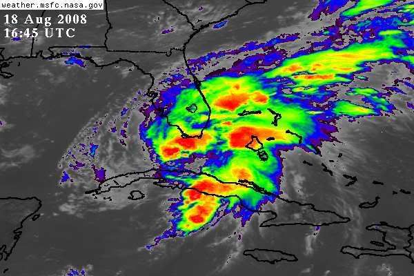
According to radar, the Keys are currently getting hard with strong banding. The apparent surface center is still well to the SSW halfway to Cuba, and echoes there are actually weakening.
0 likes   

User avatar
Extremeweatherguy
Category 5
Category 5
Posts: 11095
Joined: Mon Oct 10, 2005 8:13 pm
Location: Florida

Re: ATL: Tropical Storm Fay in Florida Straits

#8373 Postby Extremeweatherguy » Mon Aug 18, 2008 12:12 pm

tolakram wrote:Image

and once again the hi res floater link:

http://hadar.cira.colostate.edu/ramsdis ... ive_0.html


Looking at those surface wind reports out of the keys, it seems like the center may have relocated ENE of the red circle and more toward the deeper convection.
0 likes   

User avatar
SWFLA_CANE
Tropical Storm
Tropical Storm
Posts: 196
Joined: Tue Jun 06, 2006 6:41 pm
Location: Naples, Florida

#8374 Postby SWFLA_CANE » Mon Aug 18, 2008 12:12 pm

All Collier Gov. will be closed tomorrow.
0 likes   

NEXRAD
Category 1
Category 1
Posts: 370
Joined: Fri Jul 22, 2005 12:05 am
Location: South Florida

Re: Re:

#8375 Postby NEXRAD » Mon Aug 18, 2008 12:14 pm

artist wrote:
NEXRAD wrote:
wxwonder12 wrote:Is the northward motion happening in the expected time frame or is it earlier then expected


I wouldn't consider a single fix to be a northward motion. Fay's past movement shows plenty of sudden changes with direction (more west versus more north) and with forward motion. I'd wait to see what the trend is over several hours.

- Jay


Jay, we are 30 miles to the east of the lake O. Do you think we will see anything more than ts winds here? Thanks!


This is a tricky question to answer. Based on all of the information I have thus far, I'd count on expecting conditions similar to what 1999's Hurricane Irene brought.

- Jay
0 likes   

tolakram
Admin
Admin
Posts: 20165
Age: 62
Joined: Sun Aug 27, 2006 8:23 pm
Location: Florence, KY (name is Mark)

Re: ATL: Tropical Storm Fay in Florida Straits

#8376 Postby tolakram » Mon Aug 18, 2008 12:14 pm

Extremeweatherguy wrote:
tolakram wrote:Image

and once again the hi res floater link:

http://hadar.cira.colostate.edu/ramsdis ... ive_0.html


Looking at those surface wind reports out of the keys, it seems like the center may have relocated ENE of the red circle and more toward the deeper convection.


Look at the loop I linked too. The LLC visible there looks vigorous, I doubt it's relocation but i agree the wind direction int he keys looks suspicious. Maybe a pro-met can comment?
0 likes   

User avatar
HURAKAN
Professional-Met
Professional-Met
Posts: 46086
Age: 38
Joined: Thu May 20, 2004 4:34 pm
Location: Key West, FL
Contact:

#8377 Postby HURAKAN » Mon Aug 18, 2008 12:16 pm

To put to rest the confusion about Katrina's intensity over the Everglades:

"Katrina continued west-southwestward overnight and spent only about six hours over land, mostly over the water-laden Everglades. Surface observations and velocity estimates from the Miami and Key West Doppler radars indicated that Katrina weakened over mainland Monroe County to a tropical storm with maximum sustained winds of 60 knots. The center of Tropical Storm Katrina then emerged into the southeastern Gulf of Mexico at approximately 0500 UTC on 26 August just north of Cape Sable."

Link: http://www.nhc.noaa.gov/2005atlan.shtml

The NHC's website is working in short intervals.

Back to Fay!

Image
0 likes   

NEXRAD
Category 1
Category 1
Posts: 370
Joined: Fri Jul 22, 2005 12:05 am
Location: South Florida

Re: ATL: Tropical Storm Fay in Florida Straits

#8378 Postby NEXRAD » Mon Aug 18, 2008 12:17 pm

The storm cells just offshore Broward County are beginning to show signs of weak rotation. The current spinning cell will be moving towards the Central and North Broward County coast, heading towards Oakland Park, Lauderdale-by-the-Sea, and Pompano Beach.

- Jay
0 likes   

User avatar
StJoe
S2K Supporter
S2K Supporter
Posts: 274
Age: 55
Joined: Wed Sep 01, 2004 11:55 am
Location: Wellington

Re: Florida Closings - Schools, businesses etc.

#8379 Postby StJoe » Mon Aug 18, 2008 12:17 pm

Evil Jeremy wrote:
lbvbl wrote:Anyone have any ideas about what PBC schools will be doing?


So far, they are open tomorrow, though there is speculation that they might have a half day tomorrow. It is not to late for minor changes like those.


From the PBC school board:

Hurricane Information - Updated 8/18/08
Palm Beach County schools are operating on their normal schedules today, Monday, August 18. District officials will announce between noon and six p.m. today whether any changes will be made to Tuesday's schedule. Please monitor local news media, this Web site or the emergency hotline at (561) 357-7500 for any updates.

Oh, here's the link...just update it every 1/2 hour.

http://www.palmbeachschools.org/
0 likes   

User avatar
KWT
Category 5
Category 5
Posts: 31416
Joined: Tue Aug 17, 2004 11:02 am
Location: UK!!!

#8380 Postby KWT » Mon Aug 18, 2008 12:18 pm

Seems like the center you've put there ios a touch too far east according to the vortex message, probably why it loos like the center has relocated to the east but in fact the center is actually a little to the east of where you placed it, vortex showed 23.54N 81.30W.
0 likes   


Return to “2008”

Who is online

Users browsing this forum: No registered users and 33 guests