ATL: CRISTOBAL - Post-Tropical - Discussion

Moderator: S2k Moderators

Message
Author
User avatar
CaneCurious
Tropical Storm
Tropical Storm
Posts: 160
Joined: Wed Aug 25, 2004 1:40 pm
Location: Kenner, LA

Re: Re:

#841 Postby CaneCurious » Sat Aug 23, 2014 12:45 am

ozonepete wrote:
hurrtracker79 wrote:
hectopascal wrote:Could very well start to see models shift to a track quite similar to Hurricane Isaac's path.


The posts in this forum are NOT official forecast and should not be used as such. They are just the opinion of the poster and may or may not be backed by sound meteorological data. They are NOT endorsed by any professional institution or storm2k.org. For official information, please refer to the NHC and NWS products.

can you please explain your reasoning?


You beat me to it. :) What is the reasoning for that?


Yes, I would love to know your reasoning on that. I don't see an Isaac set up at all (and living in SELA I certainly don't want that mess again)
0 likes   

User avatar
Evil Jeremy
S2K Supporter
S2K Supporter
Posts: 5463
Age: 32
Joined: Mon Apr 10, 2006 2:10 pm
Location: Los Angeles, CA

#842 Postby Evil Jeremy » Sat Aug 23, 2014 12:47 am

000
ABNT20 KNHC 230532
TWOAT

TROPICAL WEATHER OUTLOOK
NWS NATIONAL HURRICANE CENTER MIAMI FL
200 AM EDT SAT AUG 23 2014

For the North Atlantic...Caribbean Sea and the Gulf of Mexico:

Satellite and surface data indicate that the area of disturbed
weather near Hispaniola still lacks a well-defined surface
circulation. However, thunderstorm activity continues to show
signs of organization and environmental conditions are favorable
for the development of a tropical depression or storm today or
Sunday. This system is forecast to move west-northwestward over or
near the southeastern Bahamas today, and over or near the central
Bahamas on Sunday. Heavy rains and gusty winds are expected to
continue over Puerto Rico and Hispaniola today. Winds to tropical
storm force and heavy rains are expected to spread over the
southeastern Bahamas, the Turks and Caicos Islands, and the Central
Bahamas through Sunday. These rains could cause life-threatening
flash floods and mudslides, especially in the mountainous areas of
Hispaniola and Puerto Rico. An Air Force Reserve Hurricane Hunter
aircraft is scheduled to investigate the system this morning.
Interests in the Turks and Caicos and all of the Bahama Islands
should monitor the progress of this disturbance, since tropical
storm watches and warnings could be required with little advance
notice.
* Formation chance through 48 hours...high...80 percent.
* Formation chance through 5 days...high...90 percent.

$$
Forecaster Brown
0 likes   
Frances 04 / Jeanne 04 / Katrina 05 / Wilma 05 / Fay 08 / Debby 12 / Andrea 13 / Colin 16 / Hermine 16 / Matthew 16 / Irma 17

User avatar
Bocadude85
Category 5
Category 5
Posts: 2991
Age: 38
Joined: Mon Apr 18, 2005 2:20 pm
Location: Honolulu,Hi

Re:

#843 Postby Bocadude85 » Sat Aug 23, 2014 12:51 am

Evil Jeremy wrote:000
ABNT20 KNHC 230532
TWOAT

TROPICAL WEATHER OUTLOOK
NWS NATIONAL HURRICANE CENTER MIAMI FL
200 AM EDT SAT AUG 23 2014

For the North Atlantic...Caribbean Sea and the Gulf of Mexico:

Satellite and surface data indicate that the area of disturbed
weather near Hispaniola still lacks a well-defined surface
circulation. However, thunderstorm activity continues to show
signs of organization and environmental conditions are favorable
for the development of a tropical depression or storm today or
Sunday. This system is forecast to move west-northwestward over or
near the southeastern Bahamas today, and over or near the central
Bahamas on Sunday. Heavy rains and gusty winds are expected to
continue over Puerto Rico and Hispaniola today. Winds to tropical
storm force and heavy rains are expected to spread over the
southeastern Bahamas, the Turks and Caicos Islands, and the Central
Bahamas through Sunday. These rains could cause life-threatening
flash floods and mudslides, especially in the mountainous areas of
Hispaniola and Puerto Rico. An Air Force Reserve Hurricane Hunter
aircraft is scheduled to investigate the system this morning.
Interests in the Turks and Caicos and all of the Bahama Islands
should monitor the progress of this disturbance, since tropical
storm watches and warnings could be required with little advance
notice.
* Formation chance through 48 hours...high...80 percent.
* Formation chance through 5 days...high...90 percent.

$$
Forecaster Brown


Notice they now say all of the Bahama Islands should monitor 96L. Leads me to believe they are not sold on a recurve.
0 likes   

User avatar
chaser1
S2K Supporter
S2K Supporter
Posts: 5467
Age: 64
Joined: Sat Oct 15, 2005 5:59 pm
Location: Longwood, Fl

Re: ATL: INVEST 96L - Discussion

#844 Postby chaser1 » Sat Aug 23, 2014 1:00 am

Boy, sure seems as if 96l wants to defy prediction. Any other system with an E. Coast trough would be a recurve no brainer. At this point the major models seem to agree. The biggest distinction from most other years however, is the strange tropical disease SAL-Ebola (tongue-in-cheek, plus of course other "non-SAL" related instability conditions), which has largely neutered the best of tropical waves & disturbances during 2013 & 2014. So... how might this impact 96L & it's potential development & path?? At this point it would not be ridiculous to rule out the possibility of the system never quite develop into a tropical storm. Let's face it, it has had no shortage of opportunities thus far. Timing not withstanding, the 0Z 500mb run seems to depict a weak skinny ridge even up through 72 hrs. But we all know that if there is an E. Coast trough within "10 Million miles" (okay, slight exaggeration here, LOL), any deepening storm would no doubt feel it and re-curve. What if the present tropical plague were to continue to affect 96L just long enough to
1) allow the stronger 850 mb ridging to carry it more WNW than a deeper system might go... and
2) If it's delayed development caused it to be left in an area of little or no steering for approx. 12-24 hrs. Then the S.E. US ridge would slowly build north of the storm, forcing a slow west to west northwest motion toward Florida and into the Gulf.

At this point, this would seem unlikely.... except it's 2014. Such would be similar to a "poor man's Hurricane Andrew" - LOL. The differences being perhaps a Cat. 1 vs. a Cat. 5 AND also a potentially shorter fuse for local Watches & Warnings. I suppose there's a 20% chance of that scenario playing out.
0 likes   
Andy D

(For official information, please refer to the NHC and NWS products.)

User avatar
artist
Category 5
Category 5
Posts: 9792
Joined: Mon Jun 06, 2005 3:26 pm
Location: West Palm

Re: ATL: INVEST 96L - Discussion

#845 Postby artist » Sat Aug 23, 2014 1:12 am

MWatkins wrote:This is a tough forecast challenge - we're looking at anything from a hurricane in the upper Keys to a clip of Cape Hattaras - or out to sea after passing over the Bahamas.

Unfortunately there are no environmental flights scheduled until Sunday afternoon.

It's been a while since we've had a developing system moving WNW into the SW Atlantic near the peak of the season. Still a very subtle difference in the steering pattern will make a huge difference on who gets what.

Also curious what - if any - impact a strong Marie in the east Pac will have on the downstream steering flow.

MW

Good to see your thoughts here, Mike. Please continue to share as you can.
0 likes   

Frank2
Category 5
Category 5
Posts: 4061
Joined: Mon Jul 25, 2005 12:47 pm

#846 Postby Frank2 » Sat Aug 23, 2014 1:22 am

Also curious what - if any - impact a strong Marie in the east Pac will have on the downstream steering flow.


Yes, that's been my question for a few days - at least perhaps it would increase GOM shear, I'd guess.

The WV loop once again shows an elongated ULL east of FL that's been around for a few days - we'll see what happens...

Frank
Last edited by Frank2 on Sat Aug 23, 2014 1:31 am, edited 1 time in total.
0 likes   

User avatar
chaser1
S2K Supporter
S2K Supporter
Posts: 5467
Age: 64
Joined: Sat Oct 15, 2005 5:59 pm
Location: Longwood, Fl

Re: ATL: INVEST 96L - Discussion

#847 Postby chaser1 » Sat Aug 23, 2014 1:27 am

96L continues to look as good as it has thus far, yet I'm sitting here trying to figure exactly why. BUT, OF COURSE! It was in need of a mountainous terrain! :cheesy:
0 likes   
Andy D

(For official information, please refer to the NHC and NWS products.)

User avatar
wyq614
Category 3
Category 3
Posts: 827
Age: 37
Joined: Sun Dec 02, 2007 12:32 am
Location: Beijing, China (Hometown: Qingdao, China, 36.06N 120.43E)
Contact:

#848 Postby wyq614 » Sat Aug 23, 2014 1:33 am

Cuban INSMET says:

In Eastern Provinces there will be numerous showers and some thunderstorms which will expand to the northern coast of Central Provinces in the evening. For the western provinces, it will be few clouds in the morning and occasionally cloudy in the afternoon with isolated showers.

...

The wind direction will be NE with 10-25 km/h but 35 km/h for the eastern north coast, with higher gusty winds.


http://www.insmet.cu/asp/genesis.asp?TB ... co/pth.txt

BTW, I think if it were CMA (Chinese Meteorological Agency) that is in charge of the Northern Atlantic, 96L would be upgraded to a TD earlier today even yesterday, if not a TS, regardless of whether a well-defined LLCC is found, and make the Bahamas, Turks and Caicos, Hispaniola to apply TS Watch/Warning without worry about "little advance notice", simply because there are two many countries and islands and interests nearby and it's always better for them to get serious about this and prepared as earlier as possible.

NHC has a lot of advanced techniques, it has recon and almost all necessary, but I wonder if it should be more flexible about designations of a TD, even a weak TS.
0 likes   

ozonepete
Professional-Met
Professional-Met
Posts: 4743
Joined: Mon Sep 07, 2009 3:23 pm
Location: From Ozone Park, NYC / Now in Brooklyn, NY

Re:

#849 Postby ozonepete » Sat Aug 23, 2014 1:42 am

wyq614 wrote:Cuban INSMET says:

In Eastern Provinces there will be numerous showers and some thunderstorms which will expand to the northern coast of Central Provinces in the evening. For the western provinces, it will be few clouds in the morning and occasionally cloudy in the afternoon with isolated showers.

...

The wind direction will be NE with 10-25 km/h but 35 km/h for the eastern north coast, with higher gusty winds.


http://www.insmet.cu/asp/genesis.asp?TB ... co/pth.txt

BTW, I think if it were CMA (Chinese Meteorological Agency) that is in charge of the Northern Atlantic, 96L would be upgraded to a TD earlier today even yesterday, if not a TS, regardless of whether a well-defined LLCC is found, and make the Bahamas, Turks and Caicos, Hispaniola to apply TS Watch/Warning without worry about "little advance notice", simply because there are two many countries and islands and interests nearby and it's always better for them to get serious about this and prepared as earlier as possible.

NHC has a lot of advanced techniques, it has recon and almost all necessary, but I wonder if it should be more flexible about designations of a TD, even a weak TS.


Good questions my friend. Maybe, counterintuitively, the more technology we have the more cautious we get?
0 likes   

tolakram
Admin
Admin
Posts: 20009
Age: 62
Joined: Sun Aug 27, 2006 8:23 pm
Location: Florence, KY (name is Mark)

Re:

#850 Postby tolakram » Sat Aug 23, 2014 1:46 am

wyq614 wrote:Cuban INSMET says:

In Eastern Provinces there will be numerous showers and some thunderstorms which will expand to the northern coast of Central Provinces in the evening. For the western provinces, it will be few clouds in the morning and occasionally cloudy in the afternoon with isolated showers.

...

The wind direction will be NE with 10-25 km/h but 35 km/h for the eastern north coast, with higher gusty winds.


http://www.insmet.cu/asp/genesis.asp?TB ... co/pth.txt

BTW, I think if it were CMA (Chinese Meteorological Agency) that is in charge of the Northern Atlantic, 96L would be upgraded to a TD earlier today even yesterday, if not a TS, regardless of whether a well-defined LLCC is found, and make the Bahamas, Turks and Caicos, Hispaniola to apply TS Watch/Warning without worry about "little advance notice", simply because there are two many countries and islands and interests nearby and it's always better for them to get serious about this and prepared as earlier as possible.

NHC has a lot of advanced techniques, it has recon and almost all necessary, but I wonder if it should be more flexible about designations of a TD, even a weak TS.


I think they will be forced to change at some point. The fact they don't issue tropical warnings until they declare the storm tropical has always bothered me. They are forecasters, and if they think a tropical storm will form then by all means do at least a watch. Sandy forced one round of changes on the back side of these storms, and I think more changes to designations and watches/warnings are appropriate on the front side. IMO of course. :)
0 likes   
M a r k
- - - - -
Join us in chat: Storm2K Chatroom Invite. Android and IOS apps also available.

The posts in this forum are NOT official forecasts and should not be used as such. Posts are NOT endorsed by any professional institution or STORM2K.org. For official information and forecasts, please refer to NHC and NWS products.

User avatar
Evil Jeremy
S2K Supporter
S2K Supporter
Posts: 5463
Age: 32
Joined: Mon Apr 10, 2006 2:10 pm
Location: Los Angeles, CA

Re: Re:

#851 Postby Evil Jeremy » Sat Aug 23, 2014 1:49 am

tolakram wrote:I think they will be forced to change at some point. The fact they don't issue tropical warnings until they declare the storm tropical has always bothered me. They are forecasters, and if they think a tropical storm will form then by all means do at least a watch. Sandy forced one round of changes on the back side of these storms, and I think more changes to designations and watches/warnings are appropriate on the front side. IMO of course. :)


The NHC has discussed doing this before. I forget which convention, pretty sure it was the Galveston Workshop a few years ago, the NHC said they were looking into issuing watches/warnings for disturbances that had a likelyhood of becoming cyclones. They never tested it though.
0 likes   
Frances 04 / Jeanne 04 / Katrina 05 / Wilma 05 / Fay 08 / Debby 12 / Andrea 13 / Colin 16 / Hermine 16 / Matthew 16 / Irma 17

MWatkins
S2K Supporter
S2K Supporter
Posts: 2574
Joined: Sat Oct 12, 2002 7:51 pm
Location: SE Florida
Contact:

Re: ATL: INVEST 96L - Discussion

#852 Postby MWatkins » Sat Aug 23, 2014 1:50 am

I'd put the center near 20.5N 70.5W based on IR2 imagery:

http://www.ssd.noaa.gov/PS/TROP/floater ... short.html

SAB puts the center near 19.6N 69.5W but notes center may be further south over land:

http://www.ssd.noaa.gov/PS/TROP/DATA/20 ... 96L.htmlMW

MW

(PS thanks Artist!)
0 likes   
Updating on the twitter now: http://www.twitter.com/@watkinstrack

User avatar
bahamaswx
Category 5
Category 5
Posts: 1542
Joined: Sat Sep 13, 2003 1:11 am
Location: Georgetown, Bahamas

Re:

#853 Postby bahamaswx » Sat Aug 23, 2014 1:50 am

wyq614 wrote:Cuban INSMET says:

In Eastern Provinces there will be numerous showers and some thunderstorms which will expand to the northern coast of Central Provinces in the evening. For the western provinces, it will be few clouds in the morning and occasionally cloudy in the afternoon with isolated showers.

...

The wind direction will be NE with 10-25 km/h but 35 km/h for the eastern north coast, with higher gusty winds.


http://www.insmet.cu/asp/genesis.asp?TB ... co/pth.txt

BTW, I think if it were CMA (Chinese Meteorological Agency) that is in charge of the Northern Atlantic, 96L would be upgraded to a TD earlier today even yesterday, if not a TS, regardless of whether a well-defined LLCC is found, and make the Bahamas, Turks and Caicos, Hispaniola to apply TS Watch/Warning without worry about "little advance notice", simply because there are two many countries and islands and interests nearby and it's always better for them to get serious about this and prepared as earlier as possible.

NHC has a lot of advanced techniques, it has recon and almost all necessary, but I wonder if it should be more flexible about designations of a TD, even a weak TS.


I don't know a single person here who isn't aware that there's a storm coming, whether it's designated a weak TS or not.
0 likes   

User avatar
Evil Jeremy
S2K Supporter
S2K Supporter
Posts: 5463
Age: 32
Joined: Mon Apr 10, 2006 2:10 pm
Location: Los Angeles, CA

#854 Postby Evil Jeremy » Sat Aug 23, 2014 1:58 am

TCFA was issued this evening. Did a forum search and notice no one posted it.

Image

WTNT21 KNGU 221700
SUBJ/TROPICAL CYCLONE FORMATION ALERT REISSUED //
REF/A/FLEWEACEN NORFOLK VA/211943Z AUG 14//
AMPN/REF IS TROPICAL CYCLONE FORMATION ALERT (WTNT21 KNGU 212000)//
RMKS/THIS ALERT SUPERSEDES REF A.
1. FORMATION OF A SIGNIFICANT TROPICAL CYCLONE IS POSSIBLE WITHIN
200 NM EITHER SIDE OF A LINE FROM 19.4N 65.4W TO 25.1N 73.5W
WITHIN THE NEXT 12 TO 24 HOURS. AVAILABLE DATA DOES NOT JUSTIFY
ISSUANCE OF NUMBERED TROPICAL CYCLONE WARNINGS AT THIS TIME.
WINDS IN THE AREA ARE ESTIMATED TO BE 25 TO 35 KNOTS. METSAT
IMAGERY AT 221200Z INDICATES THAT A CIRCULATION CENTER IS LOCATED
NEAR 19.2N 65.1W. THE SYSTEM IS MOVING WEST-NORTHWESTWARD AT 30
KNOTS.
2. REMARKS: CURRENT MODEL GUIDANCE IS COMING INTO A BETTER AGREEMENT
WITH THE TRACK OF THIS DISTURBANCE. THE CONVECTION IS BECOMING
BETTER ORGANIZED, AND THE SYSTEM WILL BE MOVING INTO AN AREA OF MORE
FAVORABLE CONDITIONS OVER THE NEXT 24 HOURS.
3. THIS ALERT WILL BE REISSUED, UPGRADED TO WARNING OR CANCELLED BY
231600Z.//
0 likes   
Frances 04 / Jeanne 04 / Katrina 05 / Wilma 05 / Fay 08 / Debby 12 / Andrea 13 / Colin 16 / Hermine 16 / Matthew 16 / Irma 17

tolakram
Admin
Admin
Posts: 20009
Age: 62
Joined: Sun Aug 27, 2006 8:23 pm
Location: Florence, KY (name is Mark)

Re: ATL: INVEST 96L - Discussion

#855 Postby tolakram » Sat Aug 23, 2014 2:00 am

0 likes   
M a r k
- - - - -
Join us in chat: Storm2K Chatroom Invite. Android and IOS apps also available.

The posts in this forum are NOT official forecasts and should not be used as such. Posts are NOT endorsed by any professional institution or STORM2K.org. For official information and forecasts, please refer to NHC and NWS products.

User avatar
artist
Category 5
Category 5
Posts: 9792
Joined: Mon Jun 06, 2005 3:26 pm
Location: West Palm

#856 Postby artist » Sat Aug 23, 2014 2:02 am

Well, hopefully recon can give us a clearer picture later on today. Those anywhere in the Bahamas, Cuba, Turks and Caicos and se US, et al, be sure to check your supplies and use this time to prepare, just in case, whether this hits or one further down the road could. It hurts to be unprepared and hit alot worse than being prepared and nothing hits.
0 likes   

User avatar
Hammy
Category 5
Category 5
Posts: 5849
Age: 41
Joined: Fri May 25, 2012 5:25 pm
Contact:

#857 Postby Hammy » Sat Aug 23, 2014 2:21 am

Given cycloneye's estimate of where the center was at earlier, and watching (what appears to be) low cloud motion, I'd say that a circulation has likely formed and is right on the coast near 59.5. The hole in the convection east of the Haitian border shows apparent inflow from the NW and WNW.
0 likes   
The above post is not official and should not be used as such. It is the opinion of the poster and may or may not be backed by sound meteorological data. It is not endorsed by any professional institution or storm2k.org. For official information, please refer to the NHC and NWS products.

Alyono
Professional-Met
Professional-Met
Posts: 6961
Joined: Fri Apr 26, 2013 3:52 pm
Location: Texas Coast

#858 Postby Alyono » Sat Aug 23, 2014 3:09 am

shear and Hispañiola have really taken a toll on this. Very possible nothing forms until Sunday now
0 likes   

ozonepete
Professional-Met
Professional-Met
Posts: 4743
Joined: Mon Sep 07, 2009 3:23 pm
Location: From Ozone Park, NYC / Now in Brooklyn, NY

Re: ATL: INVEST 96L - Discussion

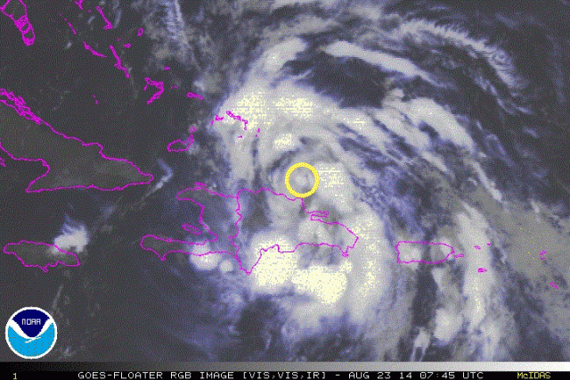
#859 Postby ozonepete » Sat Aug 23, 2014 3:27 am

The center is really obvious now, thanks to rgb satellite images. It's definitely north of the Hispaniola coast.

Image
0 likes   

User avatar
bahamaswx
Category 5
Category 5
Posts: 1542
Joined: Sat Sep 13, 2003 1:11 am
Location: Georgetown, Bahamas

#860 Postby bahamaswx » Sat Aug 23, 2014 3:27 am

Yep. Way too much interaction with the DR.
0 likes   


Return to “2014”

Who is online

Users browsing this forum: No registered users and 5 guests