
Area of 5500 CAPE east of the core.
Helicity increasing now,
300mb winds 30kt over this area.
As a result STP is at 3.
So we may have the tornado outbreak after all.
Will be watching this very closely. Will post updates as they develop.
ATL: FRANCINE - Remnants - Discussion
Moderator: S2k Moderators

Re: ATL: FRANCINE - Hurricane - Discussion
MEANINGLESS_NUMBERS wrote:Sheer increasing. No improvement on satellite. Recon is finding rising pressures. NHC's predicted strengthening may not happen.
The predicted strengthening has already happened. An extra 5 kts to reach cat 2 isn't very significant.
5 likes
Igor 2010, Sandy 2012, Fay 2014, Gonzalo 2014, Joaquin 2015, Nicole 2016, Humberto 2019, Imelda 2025
I am only a tropical weather enthusiast. My predictions are not official and may or may not be backed by sound meteorological data. For official information, please refer to the NHC and NWS products.
I am only a tropical weather enthusiast. My predictions are not official and may or may not be backed by sound meteorological data. For official information, please refer to the NHC and NWS products.
-
storm_in_a_teacup

- Category 1

- Posts: 496
- Age: 33
- Joined: Wed Aug 16, 2017 5:01 pm
- Location: Huntsville, Alabama (originally from Houston)
- Contact:
Re: ATL: FRANCINE - Hurricane - Discussion
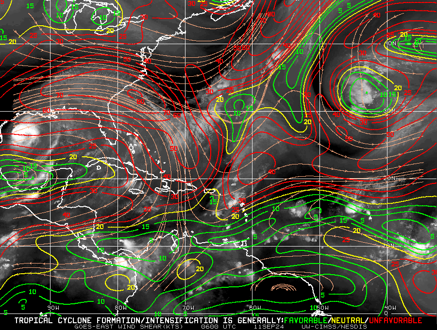
Teban54 wrote:It does look like Francine is at most holding steady if not weakening slightly. Pressure has remained generally unchanged (and maybe risen a little bit), and any winds that support 80 kt (if any) are rather limited with unimpressive SFMR. I wouldn't rule out a slight bump at the last minute to Cat 2, however, and impacts will be the same regardless: tornados will be the biggest story.
Remember that Francine has a rather impressive intensification phase last night when shear looked like this. This is why strong shear isn't automatically a death sentence.
https://i.postimg.cc/cCGnKRKL/image.png
Any idea why the intense shear isn't hurting Francine? Does it have something to do with the orientation of it?
0 likes
I know I can't straddle the atmosphere...just a tiny storm in your teacup, girl.
-
Sciencerocks
- Category 5

- Posts: 10181
- Age: 40
- Joined: Thu Jul 06, 2017 1:51 am

-
MGC

- S2K Supporter

- Posts: 5940
- Joined: Sun Mar 23, 2003 9:05 pm
- Location: Pass Christian MS, or what is left.
Re: ATL: FRANCINE - Hurricane - Discussion
Good to see the pressure rise, hope it falls apart soon. 60 mile wide eye according to recon....MGC
0 likes

-
MississippiWx

- S2K Supporter
- Posts: 1720
- Joined: Sat Aug 14, 2010 1:44 pm
- Location: Hattiesburg, Mississippi
Re: ATL: FRANCINE - Hurricane - Discussion
The center is tightening up on radar as a hot tower can be seen rotating around on the satellite imagery. Could be one more attempt at strengthening if it can persist.
1 likes
This post is not an official forecast and should not be used as such. It is just the opinion of MississippiWx and may or may not be backed by sound meteorological data. It is not endorsed by any professional institution including storm2k.org. For Official Information please refer to the NHC and NWS products.

Re: ATL: FRANCINE - Hurricane - Discussion
MississippiWx wrote:The center is tightening up on radar as a hot tower can be seen rotating around on the satellite imagery. Could be one more attempt at strengthening if it can persist.
Agreed, and also recon is finding FL winds near 90 kts again. Of course this happened right after I commented on how she's at most holding steady lol.
3 likes
TC naming lists: retirements and intensity
Most aggressive Advisory #1's in North Atlantic (cr. kevin for starting the list)
Most aggressive Advisory #1's in North Atlantic (cr. kevin for starting the list)
-
MississippiWx
- S2K Supporter
- Posts: 1720
- Joined: Sat Aug 14, 2010 1:44 pm
- Location: Hattiesburg, Mississippi
Re: ATL: FRANCINE - Hurricane - Discussion
Teban54 wrote:MississippiWx wrote:The center is tightening up on radar as a hot tower can be seen rotating around on the satellite imagery. Could be one more attempt at strengthening if it can persist.
Agreed, and also recon is finding FL winds near 90 kts again. Of course this happened right after I commented on how she's at most holding steady lol.
The hurricane models show her strengthening until landfall, so I guess it's possible.
0 likes
This post is not an official forecast and should not be used as such. It is just the opinion of MississippiWx and may or may not be backed by sound meteorological data. It is not endorsed by any professional institution including storm2k.org. For Official Information please refer to the NHC and NWS products.
-
MarioProtVI
- Category 5
- Posts: 1034
- Age: 24
- Joined: Sun Sep 29, 2019 7:33 pm
- Location: New Jersey
Re: ATL: FRANCINE - Hurricane - Discussion
Teban54 wrote:MississippiWx wrote:The center is tightening up on radar as a hot tower can be seen rotating around on the satellite imagery. Could be one more attempt at strengthening if it can persist.
Agreed, and also recon is finding FL winds near 90 kts again. Of course this happened right after I commented on how she's at most holding steady lol.
750 mb height though which is still ~79 kt converted so still holding steady.
0 likes
-
ColdMiser123

- Professional-Met

- Posts: 905
- Age: 29
- Joined: Mon Sep 26, 2016 3:26 pm
- Location: Northeast US
Re: ATL: FRANCINE - Hurricane - Discussion
I'd want to see the hurricane hunters sampling the eastern semicircle much more, especially as Francine continues to close in on landfall. Hurricane models show jet-enhanced winds in this area just before landfall. That sampling will give us a better idea as to what the max winds actually are.
As is, hurricane hunters just found flight level wind of 91 kt in the SE quadrant, which would support an intensity right on the border of Cat 1/Cat 2.
As is, hurricane hunters just found flight level wind of 91 kt in the SE quadrant, which would support an intensity right on the border of Cat 1/Cat 2.
0 likes
B.S., M.S., Meteorology & Atmospheric Science
-
Cunxi Huang

- Category 1
- Posts: 329
- Age: 27
- Joined: Thu Sep 26, 2013 12:17 pm
- Location: San Jose, CA
- Contact:
Re: ATL: FRANCINE - Hurricane - Discussion
FL 91 kt in the SE quad... Radar's getting better as well. I would say we might see a Cat.2 upgrade the next public advisory.

0 likes
06 SuTY SAOMAI | 09 TY LINFA | 10 TY FANAPI | 10 SuTY MEGI | 16 SuTY MERANTI | 19 SuTY LEKIMA | 24 C2 FRANCINE
DO NOT use my posts for life and death decisions. For official information, please refer to products from your RSMC and national weather agency.
DO NOT use my posts for life and death decisions. For official information, please refer to products from your RSMC and national weather agency.
Re: ATL: FRANCINE - Hurricane - Discussion
Last eye drop showing a saturated core. She is not giving up
1 likes
-
Pipelines182
- Tropical Storm

- Posts: 159
- Joined: Tue Jul 02, 2024 8:46 am
Re: ATL: FRANCINE - Hurricane - Discussion
storm_in_a_teacup wrote:Teban54 wrote:It does look like Francine is at most holding steady if not weakening slightly. Pressure has remained generally unchanged (and maybe risen a little bit), and any winds that support 80 kt (if any) are rather limited with unimpressive SFMR. I wouldn't rule out a slight bump at the last minute to Cat 2, however, and impacts will be the same regardless: tornados will be the biggest story.
Remember that Francine has a rather impressive intensification phase last night when shear looked like this. This is why strong shear isn't automatically a death sentence.
https://i.postimg.cc/cCGnKRKL/image.png
Any idea why the intense shear isn't hurting Francine? Does it have something to do with the orientation of it?
Maybe someone with more knowledge than me can chime in but from what I've seen when a storm is moving in the same direction as the shear vector, the impacts are far less destructive for a given shear value. Whenever you see a storm get quickly completely sheared off, like a candle getting blown out, is when the movement is near opposite of the shear vector.
3 likes
-
Tailgater33
- Tropical Depression

- Posts: 94
- Joined: Thu Jun 02, 2022 9:15 am
Re: ATL: FRANCINE - Hurricane - Discussion
104 Flight level winds outbound to southeast of last VDM?
0 likes
Re: ATL: FRANCINE - Hurricane - Discussion
Looks like some big time eyewall building happening
2 likes
Re: ATL: FRANCINE - Hurricane - Discussion
So, it seems like the unexpected strengthening is correlating with the undisclosed factor I mentioned earlier.
This likely due to the impact of a solar stream and subsequent heating of the ionosphere.
Note the sudden jump in density.
https://solarham.com/solarwind.htm
Ionospheric heating is seen here
https://solarham.com/globald.htm
This likely due to the impact of a solar stream and subsequent heating of the ionosphere.
Note the sudden jump in density.
https://solarham.com/solarwind.htm
Ionospheric heating is seen here
https://solarham.com/globald.htm
2 likes
-
Hurricane2022

- Category 5
- Posts: 2016
- Joined: Tue Aug 23, 2022 11:38 pm
- Location: Araçatuba, Brazil
Re: ATL: FRANCINE - Hurricane - Discussion
What the hell
?⁹⁷⁶⁴


?⁹⁷⁶⁴
Last edited by Hurricane2022 on Wed Sep 11, 2024 10:47 am, edited 2 times in total.
1 likes
Sorry for the bad English sometimes...!
For reliable and detailed information for any meteorological phenomenon, please consult the National Hurricane Center, Joint Typhoon Warning Center , or your local Meteo Center.
--------
ECCE OMNIA NOVA FACIAM (Ap 21,5).
For reliable and detailed information for any meteorological phenomenon, please consult the National Hurricane Center, Joint Typhoon Warning Center , or your local Meteo Center.
--------
ECCE OMNIA NOVA FACIAM (Ap 21,5).
Who is online
Users browsing this forum: No registered users and 33 guests