
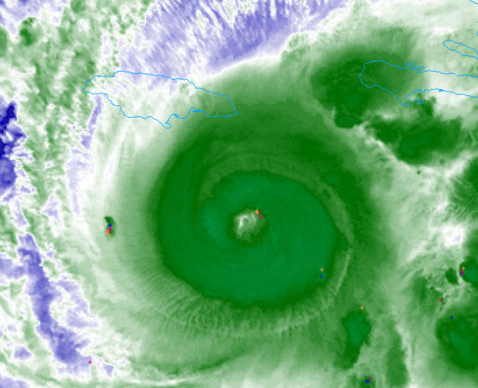
I almost wonder if such a thick eyewall will allow Melissa to just spend the next 36 hours before landfall without an EWRC at all.
NATL: MELISSA - Aftermath - Discussion
Moderator: S2k Moderators
Re: NATL: MELISSA - Hurricane - Discussion
I almost wonder if such a thick eyewall will allow Melissa to just spend the next 36 hours before landfall without an EWRC at all.
6 likes
TC naming lists: retirements and intensity
Most aggressive Advisory #1's in North Atlantic (cr. kevin for starting the list)
Most aggressive Advisory #1's in North Atlantic (cr. kevin for starting the list)
-
HurricaneRyan
- Category 3

- Posts: 847
- Age: 32
- Joined: Sun Dec 05, 2010 3:05 pm
Re: NATL: MELISSA - Hurricane - Discussion
this is gonna be like Ian and I'll wake up to a Cat 4/5
5 likes
Kay '22 Hilary '23
-
WaveBreaking

- Category 2

- Posts: 728
- Joined: Sun Jun 30, 2024 11:33 am
- Location: US
Re: NATL: MELISSA - Hurricane - Discussion
Keldeo1997 wrote:https://cdn.discordapp.com/attachments/1157676956674949152/1431861979290800250/IMG_5367.jpeg?ex=68fef4e2&is=68fda362&hm=3b70e929e0ffcf966f74923b7d20b31cc6553698efb3073802b70ebacc79c3b8&
Oh noooooo
Edit: Also how in heck did it get an annular structure?
That structure reminds me of Cyclone Winston at its peak.

3 likes
I am NOT a professional meteorologist, so take all of my posts with a grain of salt. My opinions are mine and mine alone.
Re: NATL: MELISSA - Hurricane - Discussion
Too bad recon left just before Melissa looked like this.

9 likes
TC naming lists: retirements and intensity
Most aggressive Advisory #1's in North Atlantic (cr. kevin for starting the list)
Most aggressive Advisory #1's in North Atlantic (cr. kevin for starting the list)
-
WaveBreaking
- Category 2
- Posts: 728
- Joined: Sun Jun 30, 2024 11:33 am
- Location: US
Re: NATL: MELISSA - Hurricane - Discussion
I feel like I’m gonna wake up to a monster in the morning.
1 likes
I am NOT a professional meteorologist, so take all of my posts with a grain of salt. My opinions are mine and mine alone.

Re: NATL: MELISSA - Hurricane - Discussion
Neither Erin nor Humberto had a raw ADT fix of more than 7.1 at any point, and Ragasa's never got higher than 7.2; Melissa has now had seven in a row at 7.2 or higher. Granted, constraints are there for a reason, this obviously isn't a Category 5 yet, and cold cloud tops in the CDO can lead to exaggerated Dvorak values - but I still think it speaks to just how impressive the storm's overall appearance is.
5 likes
-
Iceresistance

- Category 5

- Posts: 9607
- Age: 22
- Joined: Sat Oct 10, 2020 9:45 am
- Location: Tecumseh, OK/Norman, OK
Re: NATL: MELISSA - Hurricane - Discussion
Is this a full 360 gravity wave? (Image is dated by 15-20 minutes)
https://s12.gifyu.com/images/b3naQ.png
https://s12.gifyu.com/images/b3naQ.png
4 likes
Bill 2015 & Beta 2020
Winter 2020-2021
All observations are in Tecumseh, OK unless otherwise noted.
Winter posts are focused mainly for Oklahoma & Texas.
Take any of my forecasts with a grain of salt, refer to the NWS, SPC, and NHC for official information
Never say Never with weather! Because ANYTHING is possible!
Winter 2020-2021
All observations are in Tecumseh, OK unless otherwise noted.
Winter posts are focused mainly for Oklahoma & Texas.
Take any of my forecasts with a grain of salt, refer to the NWS, SPC, and NHC for official information
Never say Never with weather! Because ANYTHING is possible!
-
mrbagyo

- Category 5
- Posts: 3998
- Age: 33
- Joined: Thu Apr 12, 2012 9:18 am
- Location: 14.13N 120.98E
- Contact:
Re: NATL: MELISSA - Hurricane - Discussion
Amazing gravity wave.
Kinda reminds me of hunga tonga's shock wave

Kinda reminds me of hunga tonga's shock wave
7 likes
The posts in this forum are NOT official forecast and should not be used as such. They are just the opinion of the poster and may or may not be backed by sound meteorological data. They are NOT endorsed by any professional institution or storm2k.org. For official information, please refer to RSMC, NHC and NWS products.

Re: NATL: MELISSA - Hurricane - Discussion
mrbagyo wrote:Amazing gravity wave.
Kinda reminds me of hunga tonga's shock wave
https://s12.gifyu.com/images/b3naC.gif
Melissa literally BOMBED

1 likes
Georges '98, Irene '99, Frances '04, Jeanne '04, Katrina '05, Wilma '05, Gustav '08, Isaac '12, Matthew '16, Florence '18, Michael '18, Ian '22
-
WaveBreaking
- Category 2
- Posts: 728
- Joined: Sun Jun 30, 2024 11:33 am
- Location: US
Re: NATL: MELISSA - Hurricane - Discussion
Iceresistance wrote:Is this a full 360 gravity wave? (Image is dated by 15-20 minutes)
https://s12.gifyu.com/images/b3naQ.png
https://s12.gifyu.com/images/b3naQ.png
Eyewall’s been spewing out gravity waves for a while now. That really big one came from when a large VHT wrapped around the eye.

4 likes
I am NOT a professional meteorologist, so take all of my posts with a grain of salt. My opinions are mine and mine alone.
-
WaveBreaking
- Category 2
- Posts: 728
- Joined: Sun Jun 30, 2024 11:33 am
- Location: US
Re: NATL: MELISSA - Hurricane - Discussion
Just to show how quickly things went from 0 to 100 (GIF spans from 10/21 to 10/26)
Going to bed now. Hope everyone stays safe in Jamaica.

Going to bed now. Hope everyone stays safe in Jamaica.
8 likes
I am NOT a professional meteorologist, so take all of my posts with a grain of salt. My opinions are mine and mine alone.
-
Iceresistance
- Category 5
- Posts: 9607
- Age: 22
- Joined: Sat Oct 10, 2020 9:45 am
- Location: Tecumseh, OK/Norman, OK
Re: NATL: MELISSA - Hurricane - Discussion
The eye temperature just hit the positives
2 likes
Bill 2015 & Beta 2020
Winter 2020-2021
All observations are in Tecumseh, OK unless otherwise noted.
Winter posts are focused mainly for Oklahoma & Texas.
Take any of my forecasts with a grain of salt, refer to the NWS, SPC, and NHC for official information
Never say Never with weather! Because ANYTHING is possible!
Winter 2020-2021
All observations are in Tecumseh, OK unless otherwise noted.
Winter posts are focused mainly for Oklahoma & Texas.
Take any of my forecasts with a grain of salt, refer to the NWS, SPC, and NHC for official information
Never say Never with weather! Because ANYTHING is possible!
Re: NATL: MELISSA - Hurricane - Discussion
Up to 110 kts on best track.
Also, we have a T6.0 fix from NOAA, based on constraints. DT was 6.5.
13L MELISSA 251026 0600 16.3N 76.1W ATL 110 954
Also, we have a T6.0 fix from NOAA, based on constraints. DT was 6.5.
H. REMARKS...OW EYE SURROUNDED BY CMG AND EMBEDDED IN W RESULTS IN AN E#
OF 6.0 WITH AN EADJ OF 0.5 FOR A DT OF 6.5. THE 6-HOUR AVG GIVES 6.1 SO
THIS DOES NOT JUSTIFY BREAKING CONSTRAINTS AT THIS TIME. THE MET EQUALS
5.0 BASED ON A RAPIDLY DEVELOPING 24-HOUR TREND AND THE PT EQUALS 5.5. THE
FT IS BASED ON CONSTRAINTS DUE TO THE LIMIT OF 1.0 T-NUMBER CHANGE IN
6 HOURS.
OF 6.0 WITH AN EADJ OF 0.5 FOR A DT OF 6.5. THE 6-HOUR AVG GIVES 6.1 SO
THIS DOES NOT JUSTIFY BREAKING CONSTRAINTS AT THIS TIME. THE MET EQUALS
5.0 BASED ON A RAPIDLY DEVELOPING 24-HOUR TREND AND THE PT EQUALS 5.5. THE
FT IS BASED ON CONSTRAINTS DUE TO THE LIMIT OF 1.0 T-NUMBER CHANGE IN
6 HOURS.
3 likes
-
dexterlabio
- Category 5
- Posts: 3517
- Joined: Sat Oct 24, 2009 11:50 pm
Re: NATL: MELISSA - Hurricane - Discussion
Atlantic dropping the biggest bomb of the season in late October.
0 likes
Personal Forecast Disclaimer:
The posts in this forum are NOT official forecast and should not be used as such. They are just the opinion of the poster and may or may not be backed by sound meteorological data. They are NOT endorsed by any professional institution or storm2k.org. For official information, please refer to the NHC and NWS products.
The posts in this forum are NOT official forecast and should not be used as such. They are just the opinion of the poster and may or may not be backed by sound meteorological data. They are NOT endorsed by any professional institution or storm2k.org. For official information, please refer to the NHC and NWS products.


Re: NATL: MELISSA - Hurricane - Discussion
WaveBreaking wrote:Just to show how quickly things went from 0 to 100 (GIF spans from 10/21 to 10/26)
Going to bed now. Hope everyone stays safe in Jamaica.
https://i.imgur.com/0mfOS81.gif
Perhaps even more impressive would be two side-by-side satellite photo's comparing current to 24 hours ago. An amazing transformation
2 likes
Andy D
(For official information, please refer to the NHC and NWS products.)
(For official information, please refer to the NHC and NWS products.)

Re: NATL: MELISSA - Hurricane - Discussion
Wow 
ADVANCED DVORAK TECHNIQUE
ADT-Version 9.1
Tropical Cyclone Intensity Algorithm
----- Current Analysis -----
Date : 26 OCT 2025 Time : 071021 UTC
Lat : 16:19:47 N Lon : 76:07:12 W
CI# /Pressure/ Vmax
5.6 / 954.9mb/104.6kt
Final T# Adj T# Raw T#
5.6 5.7 7.7
Estimated radius of max. wind based on IR : 13 km
Center Temp : +6.1C Cloud Region Temp : -77.4C
Scene Type : EYE
4 likes
Personal Forecast Disclaimer:
The posts in this forum are NOT official forecast and should not be used as such. They are just the opinion of the poster and may or may not be backed by sound meteorological data. They are NOT endorsed by any professional institution or storm2k.org. For official information, please refer to the NHC and NWS products.
The posts in this forum are NOT official forecast and should not be used as such. They are just the opinion of the poster and may or may not be backed by sound meteorological data. They are NOT endorsed by any professional institution or storm2k.org. For official information, please refer to the NHC and NWS products.
-
PavelGaborik10
- Category 1

- Posts: 472
- Joined: Tue Sep 04, 2018 3:23 pm

Re: NATL: MELISSA - Hurricane - Discussion
chaser1 wrote:WaveBreaking wrote:Just to show how quickly things went from 0 to 100 (GIF spans from 10/21 to 10/26)
Going to bed now. Hope everyone stays safe in Jamaica.
https://i.imgur.com/0mfOS81.gif
Perhaps even more impressive would be two side-by-side satellite photo's comparing current to 24 hours ago. An amazing transformation

6 likes
The above post is not official and should not be used as such. It is the opinion of the poster and may or may not be backed by sound meteorological data. It is not endorsed by any professional institution or storm2k.org. For official information, please refer to the NHC and NWS products.
-
eastcoastFL

- Category 5
- Posts: 3996
- Age: 44
- Joined: Thu Apr 12, 2007 12:29 pm
- Location: Palm City, FL
Re: NATL: MELISSA - Hurricane - Discussion
The storms have really filled in quickly.

2 likes
Personal Forecast Disclaimer:
The posts in this forum are NOT official forecast and should not be used as such. They are just the opinion of the poster and may or may not be backed by sound meteorological data. They are NOT endorsed by any professional institution or storm2k.org. For official information, please refer to the NHC and NWS products.
The posts in this forum are NOT official forecast and should not be used as such. They are just the opinion of the poster and may or may not be backed by sound meteorological data. They are NOT endorsed by any professional institution or storm2k.org. For official information, please refer to the NHC and NWS products.

Re: NATL: MELISSA - Hurricane - Discussion
I think by the time the recon gets there, we might have a cat 5 on are hands
1 likes
Who is online
Users browsing this forum: No registered users and 57 guests