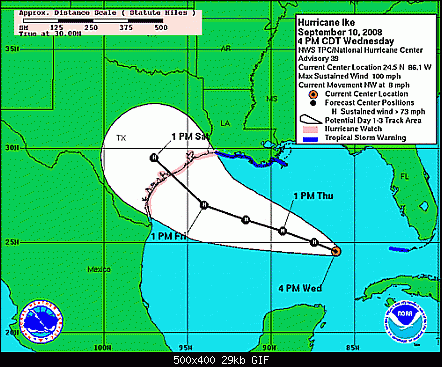
ATL: IKE Discussion

Moderator: S2k Moderators

Message
Author
smw1981
S2K Supporter
S2K Supporter
Posts: 253
Joined: Tue Jul 31, 2007 9:04 pm
Location: Alabamer

Re: Re:

#8401 Postby smw1981 » Wed Sep 10, 2008 11:10 pm

teal61 wrote:
smw1981 wrote:
Sean in New Orleans wrote:Houston will probably be on the West side of this hurricane, but, very close, so, the worst weather will probably be around Beaumont, IMO.


Fairly good news for Houston, not so good news for the area that just got slapped by Gustav (since they would be on the east side...) Lots of rain in a rain soaked area...


I think what you meant to say is would be fairly good news for Houston. As it is now we need another shift or two up the coast to be east of Houston.


Haha, yes. I meant that if Houston was on the west side, it would be good news for them and not such good news for the people who just got hit with Gustav.
0 likes   

User avatar
HarlequinBoy
Category 5
Category 5
Posts: 1400
Age: 34
Joined: Wed Nov 29, 2006 1:57 am
Location: Memphis

Re: Re:

#8402 Postby HarlequinBoy » Wed Sep 10, 2008 11:11 pm

O Town wrote:
HarlequinBoy wrote:
deltadog03 wrote:If that steering is right it will have to move generally NW.....Thats why I havn't changed my map for landfall yet....


Where is your map? I'd like to see it.


Thanks!

Maybe hes speaking of this one.


viewtopic.php?f=29&t=103095


Okay, cool.
0 likes   

User avatar
thetruesms
Professional-Met
Professional-Met
Posts: 844
Age: 41
Joined: Thu Aug 16, 2007 1:14 pm
Location: Tallahasee, FL
Contact:

Re: ATL IKE: Category 2 - Discussion

#8403 Postby thetruesms » Wed Sep 10, 2008 11:11 pm

Ed Mahmoud wrote:
Sean in New Orleans wrote:
Tireman4 wrote:Houston will probably be on the West side of this hurricane, but, very close, so, the worst weather will probably be around Beaumont, IMO.


Are you sure?


It's my opinion. I wouldn't be shocked if it hit Cameron Parish, LA, at this point. We'll see. I'm watching the same thing as everyone else and I'm forming thoughts just like the rest.


Cameron is in the cone...
Indeed. I would personally be surprised to see it happen, but at the same time, it wouldn't be like it came out of absolutely nowhere
0 likes   

HurricaneHunter914
Category 5
Category 5
Posts: 4439
Age: 31
Joined: Fri Mar 10, 2006 7:36 pm
Location: College Station, TX

Re: ATL IKE: Category 2 - Discussion

#8404 Postby HurricaneHunter914 » Wed Sep 10, 2008 11:12 pm

Ed Mahmoud wrote:
Sean in New Orleans wrote:
Tireman4 wrote:Houston will probably be on the West side of this hurricane, but, very close, so, the worst weather will probably be around Beaumont, IMO.


Are you sure?


It's my opinion. I wouldn't be shocked if it hit Cameron Parish, LA, at this point. We'll see. I'm watching the same thing as everyone else and I'm forming thoughts just like the rest.


Cameron is in the cone...


We're almost two days away from landfall. To hit LA, all of the models would need to make a major shift east. Then again, Ike was supposed to hit the Carolinas a few days earlier, so we'll see.
0 likes   

Matt-hurricanewatcher

Re: ATL IKE: Category 2 - Discussion

#8405 Postby Matt-hurricanewatcher » Wed Sep 10, 2008 11:12 pm

Personal Forecast Disclaimer:
The posts in this forum are NOT official forecast and should not be used as such. They are just the opinion of the poster and may or may not be backed by sound meteorological data. They are NOT endorsed by any professional institution or storm2k.org. For official information, please refer to the NHC and NWS products.

Based on the fact that the outter eye wall appears to be finally winning the war...I expect some strengthing as it tightens up...

Wind forecast 12am est

Now 85 knots
6 90 knots
12 100 knots
24 110 knots
36 115 knots
48 120 knots
60 75 knots inland
72 50 knots inland
96 35 knots inland
120 20 knots remant low

Based on ship data showing under 10 knots of upper level shear over the next 2-3 days...With good to very good outflow, we are expecting a higher level of strengthing then the nhc. I feel once this finally gets going it could go a little stronger then the nhc thinking. Of course another suprize like 20 knots of shear or dry air could change all this....
0 likes   

MBryant
Category 1
Category 1
Posts: 416
Joined: Fri Aug 27, 2004 7:13 pm
Location: Orange, Texas

Re: ATL IKE: Category 2 - Discussion

#8406 Postby MBryant » Wed Sep 10, 2008 11:13 pm

Lamar University just notified their students that classes were canceled for the rest of the week.
0 likes   

smw1981
S2K Supporter
S2K Supporter
Posts: 253
Joined: Tue Jul 31, 2007 9:04 pm
Location: Alabamer

#8407 Postby smw1981 » Wed Sep 10, 2008 11:13 pm

I posted this a few pages back, but Sean may not be far off according to Don Sutherland...

"For what it is worth, the 9/11 0z runs of the hurricane models (excluding the GFDL, which is not yet available) continued to feature a shift farther to the north. A number of models brings Ike onshore in north Texas, quite close to the border with Louisiana." - Don Sutherland's PM forecast tonight

Edited to say that I got this out of the Tropical Analysis Forum from his PM forecast (I think it is number 20 but I'm not completely positive about that!)
Last edited by smw1981 on Wed Sep 10, 2008 11:16 pm, edited 1 time in total.
0 likes   

User avatar
teal61
Tropical Storm
Tropical Storm
Posts: 134
Joined: Fri Jun 06, 2003 9:20 pm
Location: Spring, TX

Re: ATL IKE: Category 2 - Discussion

#8408 Postby teal61 » Wed Sep 10, 2008 11:13 pm

No shortage of opinions here for sure....I think I will stick with the pros now. Facts, not opinions or wishes. This is becoming more serious by the minutes and no one needs to make decisions based on uneducated opinions.

And yes I live near Houston. And no the idea of no electricity for a week or more does not appeal to me so don't even go there.
0 likes   

HurricaneHunter914
Category 5
Category 5
Posts: 4439
Age: 31
Joined: Fri Mar 10, 2006 7:36 pm
Location: College Station, TX

Re: ATL IKE: Category 2 - Discussion

#8409 Postby HurricaneHunter914 » Wed Sep 10, 2008 11:14 pm

Matt-hurricanewatcher wrote:Personal Forecast Disclaimer:
The posts in this forum are NOT official forecast and should not be used as such. They are just the opinion of the poster and may or may not be backed by sound meteorological data. They are NOT endorsed by any professional institution or storm2k.org. For official information, please refer to the NHC and NWS products.

Based on the fact that the outter eye wall appears to be finally winning the war...I expect some strengthing as it tightens up...

Wind forecast 12am est

Now 85 knots
6 90 knots
12 100 knots
24 110 knots
36 115 knots
48 120 knots
60 75 knots inland
72 50 knots inland
96 35 knots inland
120 20 knots remant low

Based on ship data showing under 10 knots of upper level shear over the next 2-3 days...With good to very good outflow, we are expecting a higher level of strengthing then the nhc. I feel once this finally gets going it could go a little stronger then the nhc thinking. Of course another suprize like 20 knots of shear or dry air could change all this....


Where would you put landfall Matt?
0 likes   

soonertwister
Category 5
Category 5
Posts: 1091
Joined: Mon Jun 16, 2003 2:52 pm

Re: ATL IKE: Category 2 - Discussion

#8410 Postby soonertwister » Wed Sep 10, 2008 11:15 pm

The cardinal rule for tropical systems that are projected to be major hurricanes, when you are anywhere within the cone within three days of landfall:

PREPARE FOR THE WORST, AND HOPE FOR THE BEST.
0 likes   

dwg71
Category 5
Category 5
Posts: 2349
Joined: Wed Jun 08, 2005 4:34 pm

#8411 Postby dwg71 » Wed Sep 10, 2008 11:18 pm

trough is approaching 4 corners region, no signs of letting up. how far east can ike go.

a couple of runs and GFDl could be the southern outlier. eerily similar to Rita, same timing.
0 likes   

Stormcenter
S2K Supporter
S2K Supporter
Posts: 6684
Joined: Wed Sep 03, 2003 11:27 am
Location: Houston, TX

Re: Re:

#8412 Postby Stormcenter » Wed Sep 10, 2008 11:18 pm

fasterdisaster wrote:
smw1981 wrote:
Sean in New Orleans wrote:Houston will probably be on the West side of this hurricane, but, very close, so, the worst weather will probably be around Beaumont, IMO.


Fairly good news for Houston, not so good news for the area that just got slapped by Gustav (since they would be on the east side...) Lots of rain in a rain soaked area...


Uh...you guys, this is just his opinion. The NHC has said nothing to indicate this is a done deal. The middle of the cone is left of Houston.


You must mean Houston will be on the east side unless you are not
following the NHC's advisory.
0 likes   

jdjaguar
Category 2
Category 2
Posts: 551
Joined: Fri Aug 26, 2005 12:07 pm
Location: Jacksonville Beach, FL

Re: ATL IKE: Category 2 - Discussion

#8413 Postby jdjaguar » Wed Sep 10, 2008 11:19 pm

pressure down to 940.5

:eek:
0 likes   

User avatar
Sean in New Orleans
Category 5
Category 5
Posts: 1794
Joined: Thu Aug 28, 2003 7:26 pm
Location: New Orleans, LA 30.0N 90.0W
Contact:

#8414 Postby Sean in New Orleans » Wed Sep 10, 2008 11:19 pm

Remember This:

Image

Image
0 likes   

Stormcenter
S2K Supporter
S2K Supporter
Posts: 6684
Joined: Wed Sep 03, 2003 11:27 am
Location: Houston, TX

Re: ATL IKE: Category 2 - Discussion

#8415 Postby Stormcenter » Wed Sep 10, 2008 11:19 pm

Sean in New Orleans wrote:
Tireman4 wrote:Houston will probably be on the West side of this hurricane, but, very close, so, the worst weather will probably be around Beaumont, IMO.


Are you sure?


It's my opinion. I wouldn't be shocked if it hit Cameron Parish, LA, at this point. We'll see. I'm watching the same thing as everyone else and I'm forming thoughts just like the rest.


Please be raedy to eat some NHC crow on Saturday if that's not the case.
0 likes   

smw1981
S2K Supporter
S2K Supporter
Posts: 253
Joined: Tue Jul 31, 2007 9:04 pm
Location: Alabamer

Re: ATL IKE: Category 2 - Discussion

#8416 Postby smw1981 » Wed Sep 10, 2008 11:19 pm

teal61 wrote:No shortage of opinions here for sure....I think I will stick with the pros now. Facts, not opinions or wishes. This is becoming more serious by the minutes and no one needs to make decisions based on uneducated opinions.

And yes I live near Houston. And no the idea of no electricity for a week or more does not appeal to me so don't even go there.


I agree, as that will definitely be no fun, but I think it is kind of scary that the pro mets aren't in exact agreement at this point of where LF will be. I think pretty much anywhere in the cone is fair game at this point, and the cone could still shift (which way, I don't know) according to the pro mets on this board. Good luck for whatever you have to endure though! :D
0 likes   

Stormcenter
S2K Supporter
S2K Supporter
Posts: 6684
Joined: Wed Sep 03, 2003 11:27 am
Location: Houston, TX

Re:

#8417 Postby Stormcenter » Wed Sep 10, 2008 11:21 pm

Sean in New Orleans wrote:Remember This:

Image

Image


Ike is not Rita right now and for all we know may never be.

But I can understand trying to compare the two and their tracks.
0 likes   

User avatar
ELF62
Tropical Low
Tropical Low
Posts: 12
Age: 62
Joined: Sat Jan 27, 2007 2:16 pm
Location: Brazoria, Texas
Contact:

Re: ATL IKE / Obs / Preparations / Web Cams / All of Texas Coast

#8418 Postby ELF62 » Wed Sep 10, 2008 11:21 pm

Doc Seminole wrote:Remember to check the bouys if they'll load, they get busy during storms.

I believe wave heights got to 60 feet+ with Katrina. Might give a clue as to how bad the surge is going to be.

http://www.ndbc.noaa.gov/maps/WestGulf.shtml

God Bless you all in Texas, (especially the 14th Congressional District of Texas home of Congressman Ron Paul, R-TX ) and God Bless the United States of America! :flag:

8-) Doc


Thanks Doc...Dr. Ron Paul raised his kids about 4 miles from where I'm sitting. He also delivered a bunch of babies here too. I appreciate your sentiments!!
0 likes   

User avatar
cycloneye
Admin
Admin
Posts: 145354
Age: 68
Joined: Thu Oct 10, 2002 10:54 am
Location: San Juan, Puerto Rico

Re: ATL IKE: Category 2 - Discussion

#8419 Postby cycloneye » Wed Sep 10, 2008 11:22 pm

Watch this bouy in the next few hours as the eye will pass close to it.Already winds of tropical storm force and pressure is falling.

Bouy 42001
0 likes   

User avatar
Sean in New Orleans
Category 5
Category 5
Posts: 1794
Joined: Thu Aug 28, 2003 7:26 pm
Location: New Orleans, LA 30.0N 90.0W
Contact:

#8420 Postby Sean in New Orleans » Wed Sep 10, 2008 11:23 pm

I'm not comparing strength...I'm comparing track. PLEASE everyone know it is just my amateur opinion, but, I can't shake my thoughts with this system moving so slow and how slow it has been moving since last night. Again, just my thoughts.
0 likes   


Return to “2008”

Who is online

Users browsing this forum: No registered users and 5 guests