ATL: DORIAN - Post-Tropical - Discussion
Moderator: S2k Moderators

Re: ATL: DORIAN - Hurricane - Discussion
a strike or two of lightning in the S eyewall to boot. slow deepening for now
1 likes
Very useful information on the Dvorak Technique --
https://severe.worldweather.wmo.int/TCF ... kBeven.pdf
https://severe.worldweather.wmo.int/TCF ... kBeven.pdf
-
p1nheadlarry

- Category 2

- Posts: 672
- Age: 34
- Joined: Wed Jan 29, 2014 2:42 pm
- Location: SR County FL
Re: RE: Re: ATL: DORIAN - Hurricane - Discussion
HurricaneEnzo wrote:Arthur in 2014 had a pretty nice appearance. Looked stronger that it actually was IMOsupercane4867 wrote:I can't remember a hurricane near this location that looked better than Dorian since maybe Hugo
https://uploads.disquscdn.com/images/d25cb38b657ecdf17c92f41b3d47102ba3660423eb83f6761b9f7c5212c5f9ff.png
Sent from my SM-N975U using Tapatalk
Yep and it peaked in intensity over Pamlico Sound. Fran in 96 also had a nice appearance at similar latitude and intensity (a bit stronger)
0 likes
--;->#GoNoles--;->.
-
plasticup
Re: ATL: DORIAN - Hurricane - Discussion
wx98 wrote:Is this thing going Cat 3 again?
It has plenty of time, and sure seems to be deepening.
1 likes
-
wxman57

- Moderator-Pro Met

- Posts: 23175
- Age: 68
- Joined: Sat Jun 21, 2003 8:06 pm
- Location: Houston, TX (southwest)
Re: ATL: DORIAN - Hurricane - Discussion
I can see that the NE turn has begun. Moving east of north now. Running into the SW-NE jet stream.
7 likes
-
1900hurricane

- Category 5

- Posts: 6063
- Age: 34
- Joined: Fri Feb 06, 2015 12:04 pm
- Location: Houston, TX
- Contact:
Re: ATL: DORIAN - Hurricane - Discussion
0 likes
Contract Meteorologist. TAMU & MSST. Fiercely authentic, one of a kind. We are all given free will, so choose a life meant to be lived. We are the Masters of our own Stories.
Opinions expressed are mine alone.
Follow me on Twitter at @1900hurricane : Read blogs at https://1900hurricane.wordpress.com/
Opinions expressed are mine alone.
Follow me on Twitter at @1900hurricane : Read blogs at https://1900hurricane.wordpress.com/
Re: ATL: DORIAN - Hurricane - Discussion
Filling in last 2 hours

1 likes
Very useful information on the Dvorak Technique --
https://severe.worldweather.wmo.int/TCF ... kBeven.pdf
https://severe.worldweather.wmo.int/TCF ... kBeven.pdf
-
supercane4867
- Category 5
- Posts: 4966
- Joined: Wed Nov 14, 2012 10:43 am


Re: ATL: DORIAN - Hurricane - Discussion
appreciable velocities as well

1 likes
Very useful information on the Dvorak Technique --
https://severe.worldweather.wmo.int/TCF ... kBeven.pdf
https://severe.worldweather.wmo.int/TCF ... kBeven.pdf

Re: ATL: DORIAN - Hurricane - Discussion
It kind of looks like it is getting its mojo back, but we will see.
1 likes
-
plasticup
Re: ATL: DORIAN - Hurricane - Discussion
Looking better by the hour. We might well see any upgrade with the next advisory.
1 likes
-
SunnyThoughts
- Category 5
- Posts: 2263
- Joined: Wed Jul 09, 2003 12:42 pm
- Location: Pensacola, Florida
Re: ATL: DORIAN - Hurricane - Discussion
000
WTNT65 KNHC 041956
TCUAT5
Hurricane Dorian Tropical Cyclone Update
NWS National Hurricane Center Miami FL AL052019
400 PM EDT Wed Sep 04 2019
...RAINBANDS OF DORIAN CONTINUE TO BRING HEAVY RAIN AND GUSTY
WINDS TO THE SOUTHEAST U.S. COAST...
A Weatherflow site at Folly Beach Pier, just south of Charleston,
SC, recently measured sustained winds of 39 mph (63 km/h) and a gust
to 51 mph (82 km/h).
The most recent minimum pressure reported by an Air Force Reserve
Hurricane Hunter plane was 962 mb (28.41 inches).
SUMMARY OF 400 PM EDT...2000 UTC...INFORMATION
----------------------------------------------
LOCATION...30.4N 79.8W
ABOUT 115 MI...185 KM E OF JACKSONVILLE FLORIDA
ABOUT 165 MI...265 KM S OF CHARLESTON SOUTH CAROLINA
MAXIMUM SUSTAINED WINDS...105 MPH...165 KM/H
PRESENT MOVEMENT...NNW OR 340 DEGREES AT 9 MPH...15 KM/H
MINIMUM CENTRAL PRESSURE...962 MB...28.41 INCHES
$$
Forecaster Zelinsky
0 likes
Re: ATL: DORIAN - Hurricane - Discussion
95-100 knots would be reasonable based off the FL winds for the 5pm update; clearly sfmr is having some issues
2 likes
Very useful information on the Dvorak Technique --
https://severe.worldweather.wmo.int/TCF ... kBeven.pdf
https://severe.worldweather.wmo.int/TCF ... kBeven.pdf
Re: ATL: DORIAN - Hurricane - Discussion
plasticup wrote:Looking better by the hour. We might well see any upgrade with the next advisory.
The towering mesos near the center are a good sign for intensification.
0 likes
-
Meteorcane

- Category 2
- Posts: 559
- Joined: Thu Jul 21, 2011 6:49 am
- Location: North Platte Nebraska
Re: ATL: DORIAN - Hurricane - Discussion
Given 110 kts at Flight level along with pressure lowering a couple mbs, could see an upgrade to 95 kt (although the SFMR malfunction is unfortunate). Has a little bit of time to maybe sneak back to major status before colder water and increasing shear near North Carolina should knock it down again.
1 likes
Re: ATL: DORIAN - Hurricane - Discussion
Meteorcane wrote:Given 110 kts at Flight level along with pressure lowering a couple mbs, could see an upgrade to 95 kt (although the SFMR malfunction is unfortunate). Has a little bit of time to maybe sneak back to major status before colder water and increasing shear near North Carolina should knock it down again.
The NOAA plane should go on the right hand side before the advisory. So it could give a bit of data.
1 likes
Re: ATL: DORIAN - Hurricane - Discussion
957-958 mb would seem apropos

1 likes
Very useful information on the Dvorak Technique --
https://severe.worldweather.wmo.int/TCF ... kBeven.pdf
https://severe.worldweather.wmo.int/TCF ... kBeven.pdf
-
SouthDadeFish

- Professional-Met

- Posts: 2835
- Joined: Thu Sep 23, 2010 2:54 pm
- Location: Miami, FL
- Contact:
Re: ATL: DORIAN - Hurricane - Discussion
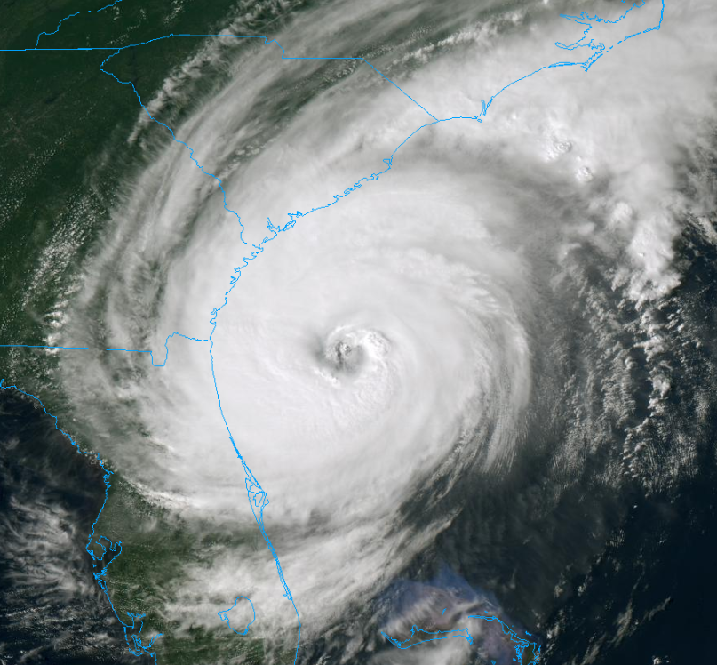
Looks like Dorian is intensifying. My thoughts below:
https://twitter.com/MikeFischerWx/status/1169339981791485952
https://twitter.com/MikeFischerWx/status/1169350940530528257
https://twitter.com/MikeFischerWx/status/1169339981791485952
https://twitter.com/MikeFischerWx/status/1169350940530528257
7 likes
Re: ATL: DORIAN - Hurricane - Discussion
961/95 kt ofcl
0 likes
Very useful information on the Dvorak Technique --
https://severe.worldweather.wmo.int/TCF ... kBeven.pdf
https://severe.worldweather.wmo.int/TCF ... kBeven.pdf
Re: ATL: DORIAN - Hurricane - Discussion
SouthDadeFish wrote:Looks like Dorian is intensifying. My thoughts below:
You used the W word.
2 likes
-
plasticup
Re: ATL: DORIAN - Hurricane - Discussion
SUMMARY OF 500 PM EDT...2100 UTC...INFORMATION
----------------------------------------------
LOCATION...30.6N 79.8W
ABOUT 150 MI...245 KM S OF CHARLESTON SOUTH CAROLINA
ABOUT 275 MI...440 KM SSW OF WILMINGTON NORTH CAROLINA
MAXIMUM SUSTAINED WINDS...110 MPH...175 KM/H
PRESENT MOVEMENT...NNW OR 345 DEGREES AT 8 MPH...13 KM/H
MINIMUM CENTRAL PRESSURE...961 MB...28.38 INCHES
Just a hair under Cat 3. I expect a major with the next update.
2 likes
Who is online
Users browsing this forum: No registered users and 74 guests