ATL: Tropical Depression Fay
Moderator: S2k Moderators
-
Aquawind

- Category 5

- Posts: 6714
- Age: 62
- Joined: Mon Jun 16, 2003 10:41 pm
- Location: Salisbury, NC
- Contact:
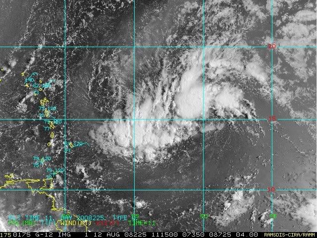
To me.. it's looking pretty good this morning with deep convection very near if not over a forming llc. The ll inflow pattern to the south looks pretty strong and much better than yesterday. I am not counting it out today yet. Visual inspection this morning is healthier than last night. The envelop looks better with the deeper convection out in front near the drier air. The shear is evident but the convection is not nearly as dispalced as it looked yesterday morning.
0 likes
Re: ATL: Invest 92L - Central Atlantic
Colocation and burst. West edge showing influence of ridge. More west track.
GFDL takes it you know where.
GFDL takes it you know where.
0 likes


-
deltadog03

- Professional-Met

- Posts: 3580
- Joined: Tue Jul 05, 2005 6:16 pm
- Location: Macon, GA
-
Ed Mahmoud
Re: ATL: Invest 92L - Central Atlantic
Just recalling what Bastardi repeated about a week ago, early season would be Florida and points West, and Texas did have two TCs, heart of the season would be Florida and points North.
I suspect he may be on to something, from his studies of analog years, but we won't know until we know. JB has said 1954 is not the best match to this year, but he sees some similarities.
IIRC, Bob was the last significant hurricane in New England. No such thing as being due, I suppose, but if there were such a thing...
0 likes
-
cycloneye

- Admin

- Posts: 149298
- Age: 69
- Joined: Thu Oct 10, 2002 10:54 am
- Location: San Juan, Puerto Rico
Re: ATL: Invest 92L - Central Atlantic
The wording in the 8 AM TWO will be very interesting.Lets see what they have to say in a few minutes.
0 likes
-
Gustywind

- Category 5
- Posts: 12334
- Joined: Mon Sep 03, 2007 7:29 am
- Location: Baie-Mahault, GUADELOUPE
http://www.weather.com/newscenter/tropical/
Mark Avery, Lead Meteorologist, The Weather Channel
6:28 a.m. ET 8/12/2008
In the Atlantic, the Hurricane Hunters are tentatively scheduled to investigate an area of low pressure that is located about 750 miles away from the Lesser Antilles this afternoon. This system is moving west-northwest around 15 miles per hour.
0 likes
-
Gustywind
- Category 5
- Posts: 12334
- Joined: Mon Sep 03, 2007 7:29 am
- Location: Baie-Mahault, GUADELOUPE
http://www.meteo.fr/temps/domtom/antill ... Tagant.jpg
Strong flaring up to the west and the south of the system near Barbados location....
Strong flaring up to the west and the south of the system near Barbados location....
0 likes
-
HURAKAN

- Professional-Met
- Posts: 46084
- Age: 39
- Joined: Thu May 20, 2004 4:34 pm
- Location: Key West, FL
- Contact:
TROPICAL WEATHER DISCUSSION
NWS TPC/NATIONAL HURRICANE CENTER MIAMI FL
805 AM EDT TUE AUG 12 2008
...SPECIAL FEATURES...
A TROPICAL WAVE LOCATED OVER THE CENTRAL ATLANTIC ALONG 50W OR
ABOUT 650 NM EAST OF THE LESSER ANTILLES IS SUPPORTING AN AREA
OF ORGANIZED SCATTERED SHOWERS AND THUNDERSTORMS FROM 14N-20N
BETWEEN 46W-56W. A 1008 MB LOW IS EMBEDDED ON THE WAVE AXIS NEAR
14N. CONVECTIVE ACTIVITY HAS PERSISTED OVER THE PAST 6-12 HOURS
AND ENVIRONMENTAL CONDITIONS APPEAR FAVORABLE FOR GRADUAL
DEVELOPMENT OF THE SYSTEM WHICH HAS THE POTENTIAL TO BECOME A
TROPICAL DEPRESSION DURING THE NEXT COUPLE OF DAYS AS IT MOVES
WEST-NORTHWESTWARD AT 15 KT.
0 likes
-
HURAKAN
- Professional-Met
- Posts: 46084
- Age: 39
- Joined: Thu May 20, 2004 4:34 pm
- Location: Key West, FL
- Contact:
667
ABNT20 KNHC 121132
TWOAT
TROPICAL WEATHER OUTLOOK
NWS TPC/NATIONAL HURRICANE CENTER MIAMI FL
800 AM EDT TUE AUG 12 2008
FOR THE NORTH ATLANTIC...CARIBBEAN SEA AND THE GULF OF MEXICO...
A BROAD AREA OF LOW PRESSURE ASSOCIATED WITH A TROPICAL WAVE IS
LOCATED 650 MILES EAST OF THE LESSER ANTILLES. ASSOCIATED SHOWER
AND THUNDERSTORM ACTIVITY HAS BEEN GRADUALLY INCREASING...AND A
TROPICAL DEPRESSION COULD FORM DURING THE NEXT DAY OR SO AS THE
SYSTEM MOVES WEST-NORTHWESTWARD OR NORTHWESTWARD AT 10 TO 15 MPH.
AN AIR FORCE RESERVE HURRICANE HUNTER AIRCRAFT IS SCHEDULED TO
INVESTIGATE THIS SYSTEM LATER TODAY...IF NECESSARY.
A LARGE AND COMPLEX AREA OF DISTURBED WEATHER IS LOCATED OVER THE
EASTERN ATLANTIC EXTENDING FROM NEAR THE CAPE VERDE ISLANDS
SOUTHWESTWARD FOR SEVERAL HUNDRED MILES. ALTHOUGH THIS SYSTEM
HAS CHANGED LITTLE IN ORGANIZATION SINCE YESTERDAY...A TROPICAL
DEPRESSION COULD STILL FORM WITHIN THIS AREA DURING THE NEXT DAY OR
TWO AS IT MOVES WESTWARD AT 10 TO 15 MPH.
SHOWERS AND THUNDERSTORMS ASSOCIATED WITH A TROPICAL WAVE OVER THE
SOUTHWESTERN CARIBBEAN SEA HAVE DIMINISHED.
ELSEWHERE.. TROPICAL CYCLONE FORMATION IS NOT EXPECTED DURING THE
NEXT 48 HOURS.
$$
FORECASTER RHOME/BROWN
0 likes
-
wxman57

- Moderator-Pro Met

- Posts: 23172
- Age: 68
- Joined: Sat Jun 21, 2003 8:06 pm
- Location: Houston, TX (southwest)
Re:
deltadog03 wrote:Wxman....I agree with the very broad/weak possible LLC....BTW, does it look like inflow is slowly increasing into the that mass of clouds??
I can see a circulation near 15.4N/51.1W on visible loops. However, it appears that circulation is not at the surface. Certainly possible it could build down to the surface if convection persists.
0 likes


-
deltadog03
- Professional-Met
- Posts: 3580
- Joined: Tue Jul 05, 2005 6:16 pm
- Location: Macon, GA
Re: Re:
wxman57 wrote:deltadog03 wrote:Wxman....I agree with the very broad/weak possible LLC....BTW, does it look like inflow is slowly increasing into the that mass of clouds??
I can see a circulation near 15.4N/51.1W on visible loops. However, it appears that circulation is not at the surface. Certainly possible it could build down to the surface if convection persists.
Ok...Thanks..I don't really see llc either. It does appear after looking hard at vis shots/loops that something is trying to spin. BTW, I am sure you seen the 00z euro last night?
0 likes
Who is online
Users browsing this forum: No registered users and 46 guests