18z HWRF is also westbound.
http://moe.met.fsu.edu/cgi-bin/hwrftc2. ... =Animation
ATL: DEBBY - Post-Tropical
Moderator: S2k Moderators
-
cycloneye

- Admin

- Posts: 148586
- Age: 69
- Joined: Thu Oct 10, 2002 10:54 am
- Location: San Juan, Puerto Rico
Re: ATL: INVEST 96L - Models
0 likes
Visit the Caribbean-Central America Weather Thread where you can find at first post web cams,radars
and observations from Caribbean basin members Click Here
and observations from Caribbean basin members Click Here

Re: Re:
TheShrimper wrote:NDG wrote:TheShrimper wrote:Where would you put that at NDG ?
Near 24N & 87.7W
Better check again. 24N isn't even in the running and 87.7W is not even close to the focal point in the Vis. Loop you provided. Just my take on what stood out in the Vis.
I am sure 100%, that LLC started slowing down and convection is starting to get closer to it and everything is starting to rotate around it at the surface.
MLC is still displaced due to the light westerly shear that is still present.
0 likes
Re:
Hurricane Andrew wrote:If you look at the VIS loop, anyone think there is a low in the centerish of the convection, at about 22.8N 86W? It's messy down there.
http://www.ssd.noaa.gov/PS/TROP/floater ... short.html
Is not on the surface, that's a mid level vorticity.
0 likes
-
Weatherfreak000
-
Portastorm

- Storm2k Moderator

- Posts: 9914
- Age: 63
- Joined: Fri Jul 11, 2003 9:16 am
- Location: Round Rock, TX
- Contact:
Re: ATL: INVEST 96L - Models
Weatherfreak000 wrote:Models backing away from development hmmmmm....
Which models?
0 likes
Any forecasts under my name are to be taken with a grain of salt. Get your best forecasts from the National Weather Service and National Hurricane Center.


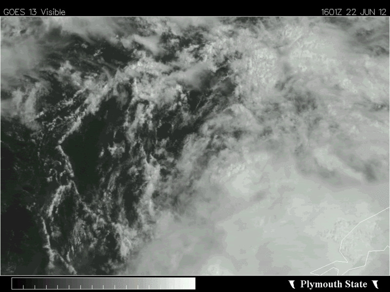
Complex VIS satellite loop over the GOM this evening. A well defined tight LLC is spinning just N of the Yucatan and moving NW while a mid level circulation is spinning to its SE midway between the Yucatan and W tip of Cuba.
0 likes
The following post is NOT an official forecast and should not be used as such. It is just the opinion of the poster and may or may not be backed by sound meteorological data. It is NOT endorsed by any professional institution including storm2k.org For Official Information please refer to the NHC and NWS products.

-
Rgv20

- S2K Supporter

- Posts: 2466
- Age: 39
- Joined: Wed Jan 05, 2011 5:42 pm
- Location: Edinburg/McAllen Tx
0 likes
The following post is NOT an official forecast and should not be used as such. It is just the opinion of the poster and may or may not be backed by sound meteorological data. It is NOT endorsed by any professional institution including storm2k.org For Official Information please refer to the NHC and NWS products.
-
tolakram
- Admin
- Posts: 20167
- Age: 62
- Joined: Sun Aug 27, 2006 8:23 pm
- Location: Florence, KY (name is Mark)
Re: ATL: INVEST 96L - Discussion
Watching the last of the visible loop this evening, I think I see what will probably be the LLC. Even the vortex that was spit out earlier is rotating around this loop.
We shall see.

Live loop (quick before it gets dark ): http://wwwghcc.msfc.nasa.gov/cgi-bin/ge ... umframes=5
We shall see.
Live loop (quick before it gets dark
0 likes
M a r k
- - - - -
Join us in chat: Storm2K Chatroom Invite. Android and IOS apps also available.
The posts in this forum are NOT official forecasts and should not be used as such. Posts are NOT endorsed by any professional institution or STORM2K.org. For official information and forecasts, please refer to NHC and NWS products.
-
Hurricane Andrew

- S2K Supporter
- Posts: 1891
- Age: 27
- Joined: Sun May 23, 2010 2:53 pm
- Location: KS
Re: ATL: INVEST 96L - Models
Portastorm wrote:Weatherfreak000 wrote:Models backing away from development hmmmmm....
Which models?
The HWRF has a very weak system, but see the post below yours.
0 likes
The Enthusiast
NREMT-AEMT, WX nerd
Irene '11, Sandy '12, Irma '17 (SAR)
"Hard to think we were born to live this way..." -Wage War
-
Nikki

- S2K Supporter
- Posts: 291
- Joined: Mon Jun 21, 2010 3:38 pm
- Location: Santa Fe, TX (yes I typed that right TEXAS not New Mexico, I am about 20 miles from Galveston, TX)
Re: Re:
NDG wrote:TheShrimper wrote:NDG wrote:So far this is the best surface vorticity that 96L has spit out, perhaps it could become the dominant circulation.
http://i20.photobucket.com/albums/b245/ ... 840_an.gif
Where would you put that at NDG ?
Near 24N & 87.7W
GOOD CALL NDG!!
0 likes
My name is Nicole and this is what I go by in Storm2k chat! Come chat with us! We have fun in there too!!
A teacher's purpose is not to create students in her own image, but to develop students who can create their own image. ~Author Unknown
Alicia, Allison, Rita, Ike
A teacher's purpose is not to create students in her own image, but to develop students who can create their own image. ~Author Unknown
Alicia, Allison, Rita, Ike
-
cycloneye
- Admin
- Posts: 148586
- Age: 69
- Joined: Thu Oct 10, 2002 10:54 am
- Location: San Juan, Puerto Rico
Re:
lester wrote:AL96, 233N 879W, 30kts, 1004mb, DB INVEST
Here is the link to the 96L Best Track.
http://ftp.nhc.noaa.gov/atcf/tcweb/inve ... 012.invest
0 likes
Visit the Caribbean-Central America Weather Thread where you can find at first post web cams,radars
and observations from Caribbean basin members Click Here
and observations from Caribbean basin members Click Here
-
Portastorm
- Storm2k Moderator
- Posts: 9914
- Age: 63
- Joined: Fri Jul 11, 2003 9:16 am
- Location: Round Rock, TX
- Contact:
Re: ATL: INVEST 96L - Models
Hurricane Andrew wrote:Portastorm wrote:Weatherfreak000 wrote:Models backing away from development hmmmmm....
Which models?
The HWRF has a very weak system, but see the post below yours.
Yes, I know. Thank you. My point was to get the poster to clarify the comment.
0 likes
Any forecasts under my name are to be taken with a grain of salt. Get your best forecasts from the National Weather Service and National Hurricane Center.
-
USTropics
- Professional-Met

- Posts: 2732
- Joined: Sun Aug 12, 2007 3:45 am
- Location: Florida State University
Re: ATL: INVEST 96L - Discussion
I've been following this all day on enhanced NASA satellite loops zoomed in and NDG is spot on with the vortex that scooted out towards the north/northwest of the persistent convection located in and around the Yucatan Channel about 2-3 hours ago but has since slowed down with some of the convection catching up and beginning to wrap around. The circluation noted in the Yucatan Channel is at the midlevels, with some hot towers looking to be firing up currently.
Last edited by USTropics on Fri Jun 22, 2012 7:43 pm, edited 2 times in total.
0 likes
-
Weatherfreak000
Re: ATL: INVEST 96L - Models
GFDL seems to stay weak, GFS spat out a random dissipation run last night. Either ukmet or nogaps keeps it weak can't remember which.
0 likes
-
cycloneye
- Admin
- Posts: 148586
- Age: 69
- Joined: Thu Oct 10, 2002 10:54 am
- Location: San Juan, Puerto Rico
Re: ATL: INVEST 96L - Models
Text of 18z GFDL.
WHXX04 KWBC 222337
CHGQLM
ATTENTION...NATIONAL HURRICANE CENTER
NCEP COUPLED GFDL HURRICANE MODEL FORECAST MADE FOR
TROPICAL DEPRESSION INVEST 96L
INITIAL TIME 18Z JUN 22
DISCLAIMER ... THIS INFORMATION IS PROVIDED AS GUIDANCE. IT
REQUIRES INTERPRETATION BY HURRICANE SPECIALISTS AND SHOULD
NOT BE CONSIDERED AS A FINAL PRODUCT. PLEASE SEE THE TPC/NHC
OFFICIAL FORECAST.
FORECAST STORM POSITION
HOUR LATITUDE LONGITUDE HEADING/SPEED(KT)
0 22.6 88.4 30./ 1.9
6 22.9 88.8 310./ 5.1
12 23.6 89.5 314./ 9.6
18 24.6 89.7 351./ 9.9
24 25.3 89.6 6./ 7.3
30 25.8 89.5 13./ 5.1
36 26.6 89.3 14./ 8.6
42 27.2 89.2 9./ 6.0
48 27.4 89.6 288./ 4.1
54 26.9 90.6 243./10.1
60 26.6 91.3 249./ 6.9
66 26.6 91.8 264./ 4.0
72 26.6 92.3 275./ 4.8
78 26.0 93.7 247./13.6
STORM DISSIPATED AT 78 HRS AT THE ABOVE PSN.
0 likes
Visit the Caribbean-Central America Weather Thread where you can find at first post web cams,radars
and observations from Caribbean basin members Click Here
and observations from Caribbean basin members Click Here

-
Frank P
- S2K Supporter
- Posts: 2779
- Joined: Fri Aug 29, 2003 10:52 am
- Location: Biloxi Beach, Ms
- Contact:
Re: ATL: INVEST 96L - Discussion
Here is the little eddy that looks to be a possible LLC... my untrained humble opinion only.. whether or not if sustains is anyone guess... very nice on the beach in Biloxi this evening...
q

q

0 likes
-
Hurricane Andrew
- S2K Supporter
- Posts: 1891
- Age: 27
- Joined: Sun May 23, 2010 2:53 pm
- Location: KS
Re:
NDG wrote:I still stand by my estimate.
Could I please have a link to that loop?
0 likes
The Enthusiast
NREMT-AEMT, WX nerd
Irene '11, Sandy '12, Irma '17 (SAR)
"Hard to think we were born to live this way..." -Wage War
-
caneman
Re: ATL: INVEST 96L - Models
Cycloneye, that run has a 25 kt. storm though. Not seeing much here to get worked up about right now. Lots of rain though.
0 likes
Who is online
Users browsing this forum: No registered users and 31 guests