
ATL: Ex-Hurricane DANIELLE - Discussion
Moderator: S2k Moderators
-
cycloneye

- Admin

- Posts: 149607
- Age: 69
- Joined: Thu Oct 10, 2002 10:54 am
- Location: San Juan, Puerto Rico
Re: ATL : Tropical Storm DANIELLE - Discussion
Trying to see?
0 likes
Visit the Caribbean-Central America Weather Thread where you can find at first post web cams,radars
and observations from Caribbean basin members Click Here
and observations from Caribbean basin members Click Here


-
ColinDelia

- S2K Supporter

- Posts: 918
- Joined: Mon Aug 29, 2005 5:52 am
- Location: The Beach, FL
Re: ATL : Tropical Storm DANIELLE - Discussion
tolakram wrote:
Of course this could aid in intensification as well.
Yeah, here is an interesting paper I read recently
http://journals.ametsoc.org/doi/pdf/10. ... -0493(2001)129%3C2570:ACSOTI%3E2.0.CO;2
"Tropical cyclones over warm water and away from
land that interact with a trough were found to be more
likely to intensify than weaken: 78% of superposition
and 61% of distant interaction cases deepened while
undergoing a trough interaction. In the favorable superposition
composite, a narrow upper-level PV maximum
extending equatorward from the poleward PV reservoir
approached the tropical cyclone center."
0 likes
-
StormClouds63
- Category 2

- Posts: 583
- Age: 62
- Joined: Tue May 13, 2008 11:56 am
- Location: Southwest Louisiana
-
DESTRUCTION5

- Category 5

- Posts: 4430
- Age: 44
- Joined: Wed Sep 03, 2003 11:25 am
- Location: Stuart, FL
Re: ATL : Tropical Storm DANIELLE - Discussion
Wont be long now till she blows, I see the fist look.
0 likes
GATOR NATION IS E V E R Y W H E R E !

Re: Re:
srainhoutx wrote:
Probably just a bit too soon to be making a blanket statement like that KWT.
Ah you know I waste no time in saying what I think, no doubts one day thats going to backfire on me in a huge way but so be it!
Looking very good now, looks like an eye is trying to get going though the western side looks a little on the weak side. Looks abit like Hurricane Karen did in 07 at its peak.
0 likes
Personal Forecast Disclaimer:
The posts in this forum are NOT official forecast and should not be used as such. They are just the opinion of the poster and may or may not be backed by sound meteorological data. They are NOT endorsed by any professional institution or storm2k.org. For official information, please refer to the NHC and NWS products
The posts in this forum are NOT official forecast and should not be used as such. They are just the opinion of the poster and may or may not be backed by sound meteorological data. They are NOT endorsed by any professional institution or storm2k.org. For official information, please refer to the NHC and NWS products
Re: ATL : Tropical Storm DANIELLE - Discussion
Hugo1989 wrote:I do not think this walk above the 14.6N
Last edited by supercane on Mon Aug 23, 2010 9:04 am, edited 1 time in total.
0 likes
-
wxman57

- Moderator-Pro Met

- Posts: 23175
- Age: 68
- Joined: Sat Jun 21, 2003 8:06 pm
- Location: Houston, TX (southwest)
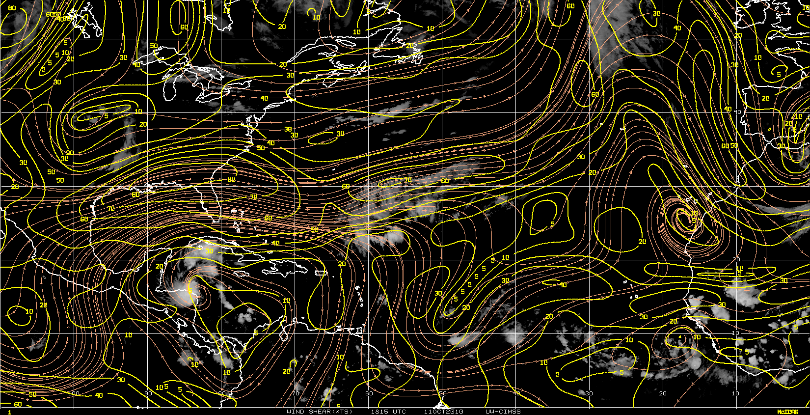
Re: ATL : Tropical Storm DANIELLE - Discussion
Here's a McIDAS shot I just took. I modified the enhancement curve to show the center better. Partial eyewall. Around 14.9N, though parallax makes it look closer to 15N:

0 likes
Re:
CrazyC83 wrote:I'd say it is up to 60 kt now with the look and eye trying to come out.
Yeah I'd agree its strengthening nicely now, I don't think its going to take till 96-120hrs to become a category-2 unless shear increases in the next 24-36hrs and halts the current strengthening trend.
Probably a hurricane later today.
0 likes
Personal Forecast Disclaimer:
The posts in this forum are NOT official forecast and should not be used as such. They are just the opinion of the poster and may or may not be backed by sound meteorological data. They are NOT endorsed by any professional institution or storm2k.org. For official information, please refer to the NHC and NWS products
The posts in this forum are NOT official forecast and should not be used as such. They are just the opinion of the poster and may or may not be backed by sound meteorological data. They are NOT endorsed by any professional institution or storm2k.org. For official information, please refer to the NHC and NWS products

Re: ATL : Tropical Storm DANIELLE - Discussion
Convection is firing much closer to the ADT Bullseye (LLC).
Core temp fluctuated quite a bite last night but now seems to be recovering.
Anti-cyclone now appears to be centered much closer to the LLC than 24 hrs ago.
This indicates IMHO an increasing updraft and strengthening system.


Core temp fluctuated quite a bite last night but now seems to be recovering.
Anti-cyclone now appears to be centered much closer to the LLC than 24 hrs ago.
This indicates IMHO an increasing updraft and strengthening system.
0 likes
Nice post Gcane and I agree conditions are getting better for this to strengthen at a quicker rate. I suspect in 24hrs time we will be looking at a 85-90kts hurricane and I still think this one has every chance of getting to major hurricane status and perhaps even slightly higher then that but who knows, all depends on how the inner core shapes up.
0 likes
Personal Forecast Disclaimer:
The posts in this forum are NOT official forecast and should not be used as such. They are just the opinion of the poster and may or may not be backed by sound meteorological data. They are NOT endorsed by any professional institution or storm2k.org. For official information, please refer to the NHC and NWS products
The posts in this forum are NOT official forecast and should not be used as such. They are just the opinion of the poster and may or may not be backed by sound meteorological data. They are NOT endorsed by any professional institution or storm2k.org. For official information, please refer to the NHC and NWS products
Re: ATL : Tropical Storm DANIELLE - Discussion
Thanks KWT.
One thing I just noticed as well.
The cell is also producing high rain rates which helps with mid/upper level latent heating.
This will help the core recover and heat back up.

One thing I just noticed as well.
The cell is also producing high rain rates which helps with mid/upper level latent heating.
This will help the core recover and heat back up.
0 likes
-
cycloneye
- Admin
- Posts: 149607
- Age: 69
- Joined: Thu Oct 10, 2002 10:54 am
- Location: San Juan, Puerto Rico
Re: ATL : Tropical Storm DANIELLE - Discussion
Remains as tropical storm at 11 AM Advisory=55kts.
From discussion.
THERE
IS NOW A 1 IN 4 CHANCE...HIGHER THAN YESTERDAY...THAT DANIELLE
COULD BECOME A MAJOR HURRICANE DURING THE NEXT 5 DAYS BASED ON
HISTORICAL NHC INTENSITY ERRORS.
From discussion.
THERE
IS NOW A 1 IN 4 CHANCE...HIGHER THAN YESTERDAY...THAT DANIELLE
COULD BECOME A MAJOR HURRICANE DURING THE NEXT 5 DAYS BASED ON
HISTORICAL NHC INTENSITY ERRORS.
0 likes
Visit the Caribbean-Central America Weather Thread where you can find at first post web cams,radars
and observations from Caribbean basin members Click Here
and observations from Caribbean basin members Click Here
I think 1 in 4 is way too low chances of this becoming a major hurricane to be honest...I'd not be surprised to see it get there within 48-72hrs actually though obviously if the shear does increase then that would make that much more unlikely.
We will see!
We will see!
0 likes
Personal Forecast Disclaimer:
The posts in this forum are NOT official forecast and should not be used as such. They are just the opinion of the poster and may or may not be backed by sound meteorological data. They are NOT endorsed by any professional institution or storm2k.org. For official information, please refer to the NHC and NWS products
The posts in this forum are NOT official forecast and should not be used as such. They are just the opinion of the poster and may or may not be backed by sound meteorological data. They are NOT endorsed by any professional institution or storm2k.org. For official information, please refer to the NHC and NWS products
-
AdamFirst

- S2K Supporter
- Posts: 2490
- Age: 36
- Joined: Thu Aug 14, 2008 10:54 am
- Location: Port Saint Lucie, FL
Re: ATL : Tropical Storm DANIELLE - Discussion
You know the nhc is always conservative with their intensity estimates. If it keeps on rolling, this is a hurricane at 11 PM at the latest.
0 likes
Dolphins Marlins Canes Golden Panthers HEAT
Andrew 1992 - Irene 1999 - Frances 2004 - Jeanne 2004 - Wilma 2005 - Fay 2008 - Isaac 2012 - Matthew 2016 - Irma 2017 - Dorian 2019 - Ian 2022 - Nicole 2022 - Milton 2024
Andrew 1992 - Irene 1999 - Frances 2004 - Jeanne 2004 - Wilma 2005 - Fay 2008 - Isaac 2012 - Matthew 2016 - Irma 2017 - Dorian 2019 - Ian 2022 - Nicole 2022 - Milton 2024
-
wxman57
- Moderator-Pro Met
- Posts: 23175
- Age: 68
- Joined: Sat Jun 21, 2003 8:06 pm
- Location: Houston, TX (southwest)
Re: ATL : Tropical Storm DANIELLE - Discussion
That 1 in 4 chance of a major hurricane is based solely on past NHC intensity forecast error. It does not take into account anything that's happening now with the storm, or any forecasts of future intensity. Actual chances may be a little higher than 1 in 4.
0 likes
Who is online
Users browsing this forum: No registered users and 66 guests