SUMMARY OF 800 AM EDT...1200 UTC...INFORMATION
----------------------------------------------
LOCATION...17.4N 83.8W
ABOUT 215 MI...345 KM SW OF GRAND CAYMAN
ABOUT 305 MI...490 KM ESE OF CHETUMAL MEXICO
MAXIMUM SUSTAINED WINDS...100 MPH...160 KM/H
PRESENT MOVEMENT...WNW OR 290 DEGREES AT 3 MPH...6 KM/H
MINIMUM CENTRAL PRESSURE...975 MB...28.79 INCHES
ATL: RINA - Post-Tropical - Discussion
Moderator: S2k Moderators
-
cycloneye

- Admin

- Posts: 149349
- Age: 69
- Joined: Thu Oct 10, 2002 10:54 am
- Location: San Juan, Puerto Rico
Re: ATL: RINA - Hurricane - Discussion
0 likes
Visit the Caribbean-Central America Weather Thread where you can find at first post web cams,radars
and observations from Caribbean basin members Click Here
and observations from Caribbean basin members Click Here

Re:
SouthDadeFish wrote:00Z Euro has Rina disappearing in four days.... Right.
The euro has been horrible with this system, IMO. I have no idea why it keeps dissipating Rina, in last nights run it shows Rina start dissipating as soon as it reach the Yucatan P, yesterday's 12z run show it start dissipating before even reaching the coast, the euro's shear forecast shows less than 8 knots of shear by Thursday night over the system, the only thing that I could think of is that dry air kills it.

0 likes
-
cycloneye
- Admin
- Posts: 149349
- Age: 69
- Joined: Thu Oct 10, 2002 10:54 am
- Location: San Juan, Puerto Rico
Re: ATL: RINA - Recon Discussion
The next plane departs at 11:00 AM EDT,but I can't be here at that time so who will help to post the data?
0 likes
Visit the Caribbean-Central America Weather Thread where you can find at first post web cams,radars
and observations from Caribbean basin members Click Here
and observations from Caribbean basin members Click Here
-
ObsessedMiami

- Category 1

- Posts: 432
- Joined: Tue Aug 31, 2004 8:08 pm
- Location: West Kendall, Fl
Re: ATL: RINA - Hurricane - Discussion
Whats the story? A CAT 2 and a whole hour goes by without a post in here? Times change....
0 likes
-
tolakram
- Admin
- Posts: 20183
- Age: 62
- Joined: Sun Aug 27, 2006 8:23 pm
- Location: Florence, KY (name is Mark)
Re: ATL: RINA - Hurricane - Discussion
ObsessedMiami wrote:Whats the story? A CAT 2 and a whole hour goes by without a post in here? Times change....
Let's stay on topic and stop fretting about early morning posts and lack of activity.
0 likes
M a r k
- - - - -
Join us in chat: Storm2K Chatroom Invite. Android and IOS apps also available.
The posts in this forum are NOT official forecasts and should not be used as such. Posts are NOT endorsed by any professional institution or STORM2K.org. For official information and forecasts, please refer to NHC and NWS products.
-
tolakram
- Admin
- Posts: 20183
- Age: 62
- Joined: Sun Aug 27, 2006 8:23 pm
- Location: Florence, KY (name is Mark)
Re: ATL: RINA - Hurricane - Discussion
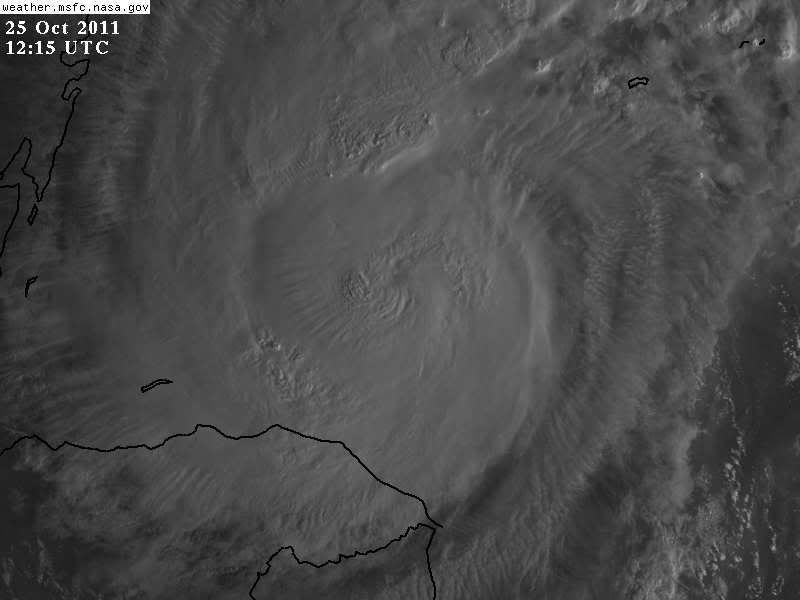
Live IR loop. Another morning blowup in convection.
http://wwwghcc.msfc.nasa.gov/cgi-bin/ge ... umframes=5
http://wwwghcc.msfc.nasa.gov/cgi-bin/ge ... umframes=5
0 likes
M a r k
- - - - -
Join us in chat: Storm2K Chatroom Invite. Android and IOS apps also available.
The posts in this forum are NOT official forecasts and should not be used as such. Posts are NOT endorsed by any professional institution or STORM2K.org. For official information and forecasts, please refer to NHC and NWS products.
- - - - -
Join us in chat: Storm2K Chatroom Invite. Android and IOS apps also available.
The posts in this forum are NOT official forecasts and should not be used as such. Posts are NOT endorsed by any professional institution or STORM2K.org. For official information and forecasts, please refer to NHC and NWS products.
-
AJC3

- Admin
- Posts: 4153
- Age: 62
- Joined: Tue Aug 31, 2004 7:04 pm
- Location: Ballston Spa, New York
- Contact:
Re: ATL: RINA - Hurricane - Discussion
It's becoming apparent to me that "something" is likely going to lift out to the NE and ENE across the Keys/straits and southern-most Florida, and that "something" is the top half of Rina.
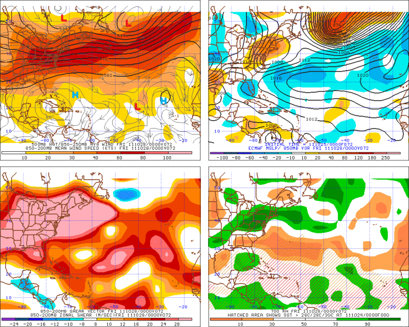
Assuming the cyclone does reach the Yucatan Channel just west of Cuba in about 4 days, thereafter I expect that Rina will completely decouple as it gets to a point not too far SW of Key West. While "it" could drag the LLC 'kicking and screaming' with it, I think that scenario is unlikely.
Since Rina is now a strong and vertically deep tropical cyclone, it simply cannot help but respond to the 500MB flow after the ridge to its north collapses. And with the large surface high building across the southeast U.S. in Florida by the end of the week, this should effectively block the LLC from keeping up with the portion of the cyclone from about 500MB on up.
my 0.000002. YOMV
0 likes
-
wxman57

- Moderator-Pro Met

- Posts: 23172
- Age: 68
- Joined: Sat Jun 21, 2003 8:06 pm
- Location: Houston, TX (southwest)
Re:
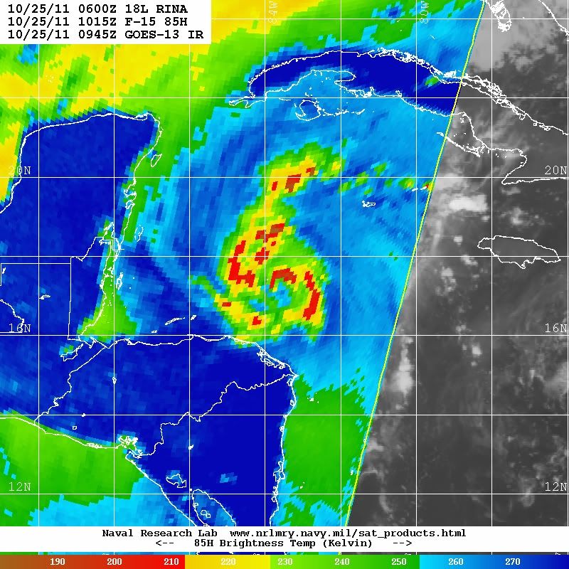
Shuriken wrote:Pinhole eye appearing at http://www.ssd.noaa.gov/goes/flt/t1/flash-rb.html
I'm not seeing it.
0 likes
-
AJC3
- Admin
- Posts: 4153
- Age: 62
- Joined: Tue Aug 31, 2004 7:04 pm
- Location: Ballston Spa, New York
- Contact:
Re:
Shuriken wrote:Pinhole eye appearing at http://www.ssd.noaa.gov/goes/flt/t1/flash-rb.html
Maybe some subtle hints of a developing warm spot, but nothing that I'd call a pinhole eye.
0 likes
-
SFLcane

- S2K Supporter

- Posts: 10281
- Age: 48
- Joined: Sat Jun 05, 2010 1:44 pm
- Location: Lake Worth Florida
Re: ATL: RINA - Hurricane - Discussion
06z GFDL coming around now has a weak ts through the keys. Just not a favorable environment that waits to its north. Likely decapitation.
0 likes
-
SootyTern
- S2K Supporter
- Posts: 316
- Age: 57
- Joined: Sun Sep 05, 2004 5:09 pm
- Location: NYC (formerly Homestead, FL)
This seems like a case of we need to watch what the storm is actually doing, not what the models say it is going to do. She is currently intensifying, a powerful front is coming; enough said. I also am confused by this turn to the ESE instead of just running up the front, even as a sheared mess.
0 likes
-
cycloneye
- Admin
- Posts: 149349
- Age: 69
- Joined: Thu Oct 10, 2002 10:54 am
- Location: San Juan, Puerto Rico
Re: ATL: RINA - Hurricane - Discussion
12z Best Track
Up to 90kts.
AL, 18, 2011102512, , BEST, 0, 174N, 838W, 90, 971, HU
Up to 90kts.
AL, 18, 2011102512, , BEST, 0, 174N, 838W, 90, 971, HU
0 likes
Visit the Caribbean-Central America Weather Thread where you can find at first post web cams,radars
and observations from Caribbean basin members Click Here
and observations from Caribbean basin members Click Here
Re: ATL: RINA - Models
My guess the ESE turn is because it has been decapitated by the trough and no longer feels the upper level winds so much as the trades.
0 likes
-
gatorcane

- S2K Supporter
- Posts: 23708
- Age: 48
- Joined: Sun Mar 13, 2005 3:54 pm
- Location: Boca Raton, FL
Re: ATL: RINA - Hurricane - Discussion
SFLcane wrote:06z GFDL coming around now has a weak ts through the keys. Just not a favorable environment that waits to its north. Likely decapitation.
The posts in this forum are NOT official forecast and should not be used as such. They are just the opinion of the poster and may or may not be backed by sound meteorological data. They are NOT endorsed by any professional institution or storm2k.org. For official information, please refer to the NHC and NWS products
I do agree with that. I don't know why people are discounting the Euro which pulverizes it and rips it to shreads in a few days. That's quite possible because very hostile conditions will be awaiting it if it tries to move out of the Caribbean towards Florida. The GFDL is an outlier (yet again) and should be discarded.
Could see decoupling as well with some weak energy passing through extreme south Florida/straits along and ahead of the cold front but can't see Rina being a significant event for Florida.
0 likes
Re: ATL: RINA - Models
xironman wrote:6z gfs still initializing this as a 1004mb low. Ends up with a weak TS near Key West.
But, the 4 day 500mb loop has a great depiction of her getting picked up by the trough http://mag.ncep.noaa.gov/NCOMAGWEB/appc ... mageSize=M
I am surprised nobody else has commented on the 06z GFS.
It keeps trending closer to S FL of at least of a tropical storm condition possible affecting the keys and extreme southern FL Friday and Saturday.

0 likes
Re: ATL: RINA - Hurricane - Discussion
gatorcane wrote:SFLcane wrote:06z GFDL coming around now has a weak ts through the keys. Just not a favorable environment that waits to its north. Likely decapitation.The posts in this forum are NOT official forecast and should not be used as such. They are just the opinion of the poster and may or may not be backed by sound meteorological data. They are NOT endorsed by any professional institution or storm2k.org. For official information, please refer to the NHC and NWS products
I do agree with that. I don't know why people are discounting the Euro which pulverizes it and rips it to shreads in a few days. That's quite possible because very hostile conditions will be awaiting it if it tries to move out of the Caribbean towards Florida.
Could see decoupling as well with some weak energy passing through extreme south Florida/straits along and ahead of the cold front but can't see Rina being a significant event for Florida.
The euro actually "pulverizes" Rina before it gets out of the Caribbean, makes no sense with UL conditions forecasted by both the GFS and Euro to be that hostile to just simply dissappear. The euro has not been handling the strength of this system that well.
0 likes
-
AdamFirst

- S2K Supporter
- Posts: 2490
- Age: 36
- Joined: Thu Aug 14, 2008 10:54 am
- Location: Port Saint Lucie, FL
Re: ATL: RINA - Models
NDG wrote:I am surprised nobody else has commented on the 06z GFS.
It keeps trending closer to S FL of at least of a tropical storm condition possible affecting the keys and extreme southern FL Friday and Saturday.
http://mag.ncep.noaa.gov/GemPakTier/Mag ... precip.gif
It also disintegrates Rina over the Keys/Florida Straits. With the front I imagine all the moisture would be ripped off the system and spread over the peninsula.
GFS has trended north with each run but hasn't stopped the weakening trend.
0 likes
Dolphins Marlins Canes Golden Panthers HEAT
Andrew 1992 - Irene 1999 - Frances 2004 - Jeanne 2004 - Wilma 2005 - Fay 2008 - Isaac 2012 - Matthew 2016 - Irma 2017 - Dorian 2019 - Ian 2022 - Nicole 2022 - Milton 2024
Andrew 1992 - Irene 1999 - Frances 2004 - Jeanne 2004 - Wilma 2005 - Fay 2008 - Isaac 2012 - Matthew 2016 - Irma 2017 - Dorian 2019 - Ian 2022 - Nicole 2022 - Milton 2024
-
AdamFirst
- S2K Supporter
- Posts: 2490
- Age: 36
- Joined: Thu Aug 14, 2008 10:54 am
- Location: Port Saint Lucie, FL
As discussed in the models thread, the 06z GFS brings Rina into Florida Bay before it completely dissolves west of mainland Monroe County and Cape Sable.
Rain event again for the peninsula? Some more moisture to add to the coffers for the dry season?
Rain event again for the peninsula? Some more moisture to add to the coffers for the dry season?
0 likes
Dolphins Marlins Canes Golden Panthers HEAT
Andrew 1992 - Irene 1999 - Frances 2004 - Jeanne 2004 - Wilma 2005 - Fay 2008 - Isaac 2012 - Matthew 2016 - Irma 2017 - Dorian 2019 - Ian 2022 - Nicole 2022 - Milton 2024
Andrew 1992 - Irene 1999 - Frances 2004 - Jeanne 2004 - Wilma 2005 - Fay 2008 - Isaac 2012 - Matthew 2016 - Irma 2017 - Dorian 2019 - Ian 2022 - Nicole 2022 - Milton 2024
Who is online
Users browsing this forum: No registered users and 20 guests