
A new burst of eyewall convection just appeared, immediately next to the "dry air channel" and near the convective blob. It's the strongest that I recall seeing this morning.
Could this be an attempt at shielding off the dry air and reintensifying?

Moderator: S2k Moderators

cheezyWXguy wrote:USTropics wrote:mrbagyo wrote:
Could that huge eastern blob of convection hindering the intensification? it appears too "heavy" for small Melissa to carry - like it's dragging the whole circulation not to spin faster.
sort of like a spinning top with uneven weight.
There are very intense storms that had strong spiral bands but their bands look "smooth". Melissa's doesn't look smooth at all
I've done a lot of research in this area, and it's definitely unique to this region like you stated. This all due to how the circulation around Melissa interacts with the prevailing easterly flow at this latitude and essentially establishes this convergence zone, or 'blob of convection' to the east of Melissa. Specifically, this is what is occurring:
1) There is a stationary band complex east of the system, or essentially confluence downshear (i.e., downshear direction is the southeast and northeast quadrant in this instance)
2) There is a surge in trade winds (see images below) coming from east -> west that interacts with this
3) We also have confluence downstream due to the vicinity of landmasses/terrain
4) Finally we have asymmetries due to mixing of drier air and these moist boundary layers
We can best see this by how the flow is completely different based on the level of the atmosphere we are in (and it doesn't impact intensity):
Surface (trade winds)
https://i.imgur.com/dDX27yf.png
Mid levels (700mb)
https://i.imgur.com/tQqTfCq.png
Upper levels (500mb)
https://i.imgur.com/mopPiDz.png
Near Troposphere (250mb)
https://i.imgur.com/xGsP9qV.png
It’s number 4 on your list that I’m suspecting to be the biggest culprit at the moment, although I’m sure it’s a combination of all like you said. Dropsondes from the southeastern half of the storm appear to be less saturated through the measured portion of the column than those from the northwestern half. Each time a band like this appeared the intensity leveled off, and after it weakened a new phase of intensification followed immediately after, which also lends credence to 1900hurricane’s lobing argument. When present, this feature seems to compete with the core for energy in some way.
Teban54 wrote:I could be reading too much into this, but...
A new burst of eyewall convection just appeared, immediately next to the "dry air channel" and near the convective blob. It's the strongest that I recall seeing this morning.
Could this be an attempt at shielding off the dry air and reintensifying?
https://i.imgur.com/05iLUyU.gif
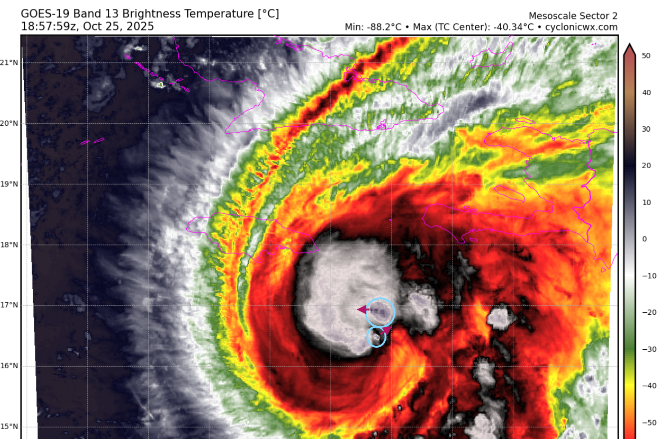
USTropics wrote:Iceresistance wrote:I think Melissa has gotten the dual VHTs, the arrows are direction. The northern VHT is moving fast
https://s12.gifyu.com/images/b3n30.png
https://s12.gifyu.com/images/b3n30.png
Definitely some VHTs induced by the dry air interaction with the moist profile of Melissa's improving inner core:
We have some dry air entrainment as Melissa starts to expand her convective envelope. Meanwhile, we have this moist inner core developing which has high equivalent potential temperature (PT). This creates these localized boundaries where inflow basically hits a wall, and we get enhanced convergence when the dry air hits the moist inflow (environment PT decreases, parcel buoyancy increases), and rapid ascent of warm, moist air takes place (our VHTs).
Each point where the dry air "hits" the moist core can initiate a separate updraft. The red VHT is optimally positioned so it has the largest vertical ascent initially. As teal continues to rotate towards the north, it gets more of those direct localized enhanced convergence effects. This is the response to balance two things: (1) the asymmetric structure that Melissa currently exhibits and (2) as a means to mix out the dry air intrusion before it reaches the inner core and disrupts the eyewall formation cycle.
https://i.imgur.com/zxBei8V.gif
LarryWx wrote:You can tell that the NHC has an extra tough challenge right now considering it’s 10:57AM EDT and the 11AM just came out. It usually comes out by 10:45AM.


Teban54 wrote:I could be reading too much into this, but...
A new burst of eyewall convection just appeared, immediately next to the "dry air channel" and near the convective blob. It's the strongest that I recall seeing this morning.
Could this be an attempt at shielding off the dry air and reintensifying?
https://i.imgur.com/05iLUyU.gif
cheezyWXguy wrote:Teban54 wrote:I could be reading too much into this, but...
A new burst of eyewall convection just appeared, immediately next to the "dry air channel" and near the convective blob. It's the strongest that I recall seeing this morning.
Could this be an attempt at shielding off the dry air and reintensifying?
https://i.imgur.com/05iLUyU.gif
I think this is true. Yesterday when this occurred, it seemed to follow this order of events:
1- prominent band forms, initially as a discrete blob, near the periphery of the cdo. Intensification levels off.
2- blob stretches into more of a classic band appearance, a moat between this band and the cdo becomes apparent.
3- new cells appear in the moat, eventually filling in as the original prominent band is gradually pushed farther away from the cdo and begins to lose influence.
4- new bursts begin to appear in the cdo/eyewall as the prominent band continues to weaken.
5- intensification resumes as eyewall bursts become stronger and band weakens further/dissipates.
If this is a repeatable sequence of events for today, I think we’re at the 4th point by now. We should watch to see if the band gets further removed from the core, new banding forms in the dry moat, and if new bursts continue to occur in the eyewall over the next couple hours.


kevin wrote:Compared to Milton or Wilma it might 'feel' like Melissa isn't intensifying nearly as fast and has more periods of constant intensity. And while it is true that this won't break the TS -> C5 record time, she still went from a 60 kt TS to a 120 kt C4 within the last 24 hours. The fact that we already knew that Melissa would bomb out long in advance also makes it feel like it's just taking a long time. But Melissa's RI is still extremely impressive.
And much more worringly, Melissa still has about 44 hours left until landfall according to the NHC (or up to 48 - 52 hours if HAFS-A/B are correct). Things don't need to line up perfectly (as is often the case for these worst-case scenarios) for a historic and extremely damaging landfall in Jamaica: it still has time for multiple EWRCs and then another RI phase into a C5 before landfall. I'm afraid this is gonna be Jamaica's 'big one'.
Hypercane_Kyle wrote:There may be another intensification burst... eye is looking more symmetrical with deep convection wrapping around again.
https://i.imgur.com/BOyWhpo.png
hipshot wrote:Hypercane_Kyle wrote:There may be another intensification burst... eye is looking more symmetrical with deep convection wrapping around again.
https://i.imgur.com/BOyWhpo.png
When do they predict that Melissa will make the right turn toward Jamaica?


Teban54 wrote:cheezyWXguy wrote:Teban54 wrote:I could be reading too much into this, but...
A new burst of eyewall convection just appeared, immediately next to the "dry air channel" and near the convective blob. It's the strongest that I recall seeing this morning.
Could this be an attempt at shielding off the dry air and reintensifying?
https://i.imgur.com/05iLUyU.gif
I think this is true. Yesterday when this occurred, it seemed to follow this order of events:
1- prominent band forms, initially as a discrete blob, near the periphery of the cdo. Intensification levels off.
2- blob stretches into more of a classic band appearance, a moat between this band and the cdo becomes apparent.
3- new cells appear in the moat, eventually filling in as the original prominent band is gradually pushed farther away from the cdo and begins to lose influence.
4- new bursts begin to appear in the cdo/eyewall as the prominent band continues to weaken.
5- intensification resumes as eyewall bursts become stronger and band weakens further/dissipates.
If this is a repeatable sequence of events for today, I think we’re at the 4th point by now. We should watch to see if the band gets further removed from the core, new banding forms in the dry moat, and if new bursts continue to occur in the eyewall over the next couple hours.
I think you're onto something. From the loop below, you can also see the new burst attempting to quickly turn itself into the new CDO (which has wrapped around 70% of the eyewall since the last frame of the loop). The blob is also showing clear separation from the core: Melissa's center has been slowly drifting W, while the blob remained somewhat stationary.
https://i.imgur.com/hWMlJhF.gif
This is quite similar to the huge burst yesterday that kickstarted the ERI (the loop here shows the whole process). For reference, the start of this loop was exactly when USTropics wrote the detailed explanation, which was quoted again upthread.
The main differences I see are:
- When the burst happened yesterday, the nearby blob has already greatly weakened. (You can see initial stages of that blob here a few hours earlier.) Right now, however, the SE quad of the blog is still quite active even when the new burst is already wrapping around.
- This process yesterday happened when Melissa was still a minimal hurricane. Since it's at a much higher intensity now, EWRC (or at least eyewall melds) may complicate things.


kevin wrote:Compared to Milton or Wilma it might 'feel' like Melissa isn't intensifying nearly as fast and has more periods of constant intensity. And while it is true that this won't break the TS -> C5 record time, she still went from a 60 kt TS to a 120 kt C4 within the last 24 hours. The fact that we already knew that Melissa would bomb out long in advance also makes it feel like it's just taking a long time. But Melissa's RI is still extremely impressive.
And much more worringly, Melissa still has about 44 hours left until landfall according to the NHC (or up to 48 - 52 hours if HAFS-A/B are correct). Things don't need to line up perfectly (as is often the case for these worst-case scenarios) for a historic and extremely damaging landfall in Jamaica: it still has time for multiple EWRCs and then another RI phase into a C5 before landfall. I'm afraid this is gonna be Jamaica's 'big one'.

Users browsing this forum: No registered users and 58 guests


