
Texas Fall-2014
Moderator: S2k Moderators
Forum rules

The posts in this forum are NOT official forecast and should not be used as such. They are just the opinion of the poster and may or may not be backed by sound meteorological data. They are NOT endorsed by any professional institution or STORM2K.
-
aggiecutter
- Category 5

- Posts: 1755
- Joined: Thu Oct 14, 2004 9:22 pm
- Location: Texarkana
Re: Texas Fall-2014
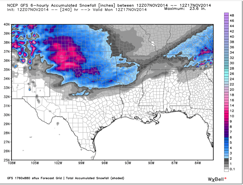
The New GFS(parallel) says those of us in North and NE Texas will be getting out the snow shovels several times over the next 10 days.
0 likes

Re: Texas Fall-2014
12z ECMWF seems to have a lot of snow in north and north central Texas next weekend, with temps in the 20's. Looks extremely cold for this time of year.
0 likes
-
South Texas Storms

- Professional-Met

- Posts: 4258
- Joined: Thu Jun 24, 2010 12:28 am
- Location: Houston, TX
Re: Texas Fall-2014
hriverajr wrote:12z ECMWF seems to have a lot of snow in north and north central Texas next weekend, with temps in the 20's. Looks extremely cold for this time of year.
Yep, the 12z Euro has about 10 inches of snow in Lubbock during the next 10 days. Crazy!
0 likes
-
TheProfessor

- Professional-Met
- Posts: 3506
- Age: 29
- Joined: Tue Dec 03, 2013 10:56 am
- Location: Wichita, Kansas


1976.
0 likes
The above post and any post by Ntxw is NOT an official forecast and should not be used as such. It is just the opinion of the poster and may or may not be backed by sound meteorological data. It is NOT endorsed by any professional institution including Storm2k. For official information, please refer to NWS products.
Help support Storm2K!


-
Tireman4

- S2K Supporter

- Posts: 5903
- Age: 60
- Joined: Fri Jun 30, 2006 1:08 pm
- Location: Humble, Texas
- Contact:
Re: Texas Fall-2014
South Texas Storms wrote:hriverajr wrote:12z ECMWF seems to have a lot of snow in north and north central Texas next weekend, with temps in the 20's. Looks extremely cold for this time of year.
Yep, the 12z Euro has about 10 inches of snow in Lubbock during the next 10 days. Crazy!
Boy if this even remotely verified, in the immortal words of Keith Jackson....Whoaaa Nellie!!!!!!!!!!!!!!!
https://www.youtube.com/watch?v=tNeOEHGpYyc
0 likes
-
srainhoutx

- S2K Supporter
- Posts: 6919
- Age: 68
- Joined: Sun Jan 14, 2007 11:34 am
- Location: Haywood County, NC
- Contact:
Re: Texas Fall-2014
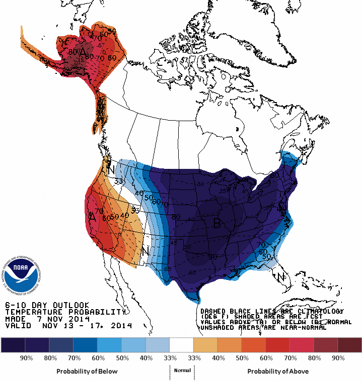
Technical analysis from the Climate Prediction Center for the Day 6 to 10 period...
PROGNOSTIC DISCUSSION FOR 6 TO 10 AND 8 TO 14 DAY OUTLOOKS
NWS CLIMATE PREDICTION CENTER COLLEGE PARK, MD
300 PM EST FRI NOVEMBER 07 2014
6-10 DAY OUTLOOK FOR NOV 13 - 17 2014
TODAY'S MODEL SOLUTIONS ARE IN EXCELLENT AGREEMENT IN PREDICTING A VERY
AMPLIFIED 500-HPA FLOW PATTERN OVER MOST OF THE FORECAST DOMAIN. THE MODELS
AGREE IN PREDICTING A STRONG TROUGH OVER THE BERING SEA. DOWNSTREAM OF THIS
FEATURE, RIDGING IS FORECAST ALONG THE WEST COAST OF NORTH AMERICA WHILE A DEEP
TROUGH IS PREDICTED OVER THE EASTERN AND CENTRAL CONUS. THE DETERMINISTIC RUNS
FROM THE GFS AND ECMWF ARE GENERALLY IN GOOD AGREEMENT WITH THEIR RESPECTIVE
ENSEMBLE MEAN SOLUTIONS. HOWEVER, TODAY'S 0Z DETERMINISTIC ECMWF AND TODAY'S
DETERMINISTIC 12Z GFS RUNS INDICATE A WESTWARD SHIFT OF THE PATTERN OVER THE
CONUS AND PULL THE PREDICTED TROUGH OVER EASTERN NORTH AMERICA MORE TOWARD THE
CENTER OF THE COUNTRY. THIS WESTWARD SHIFT IS SUPPORTED BY TELECONNECTIONS FROM
A POSITIVE HEIGHT ANOMALY CENTER OVER NORTHWESTERN CANADA IN TODAY'S MANUAL
HEIGHT BLEND. TODAY'S MANUAL 500-HPA HEIGHT BLEND IS COMPOSED PRIMARILY OF THE
ENSEMBLE MEAN SOLUTIONS AND IS BASED ON CONSIDERATIONS OF RECENT SKILL AND ON
ANALOG CORRELATIONS, WHICH MEASURE HOW CLOSELY THE FORECAST PATTERN RESEMBLES
CASES THAT HAVE OCCURRED IN THE PAST.
THE DEEP TROUGH PREDICTED OVER EAST-CENTRAL NORTH AMERICA STRONGLY FAVORS
BELOW-NORMAL TEMPERATURES FOR MOST OF THE CENTRAL AND EASTERN CONUS. HOWEVER,
NEAR-NORMAL TEMPERATURES ARE FAVORED FOR PARTS OF THE FLORIDA PENINSULA AHEAD
OF THE PREDICTED TROUGH AXIS. FORECAST RIDGING ALONG THE WEST COAST FAVORS
ABOVE-NORMAL TEMPERATURES FOR MUCH OF THE SOUTHWESTERN CONUS. ABOVE-NORMAL
TEMPERATURES ARE ALSO FAVORED FOR ALASKA UNDERNEATH ANOMALOUS SOUTHERLY FLOW
AHEAD OF THE TROUGH PREDICTED OVER THE BERING SEA.
MOIST FLOW AHEAD OF THE PREDICTED BERING SEA TROUGH FAVORS ABOVE-MEDIAN
PRECIPITATION FOR MUCH OF WESTERN AND SOUTHERN ALASKA. CONVERSELY, BELOW-MEDIAN
PRECIPITATION IS FAVORED FOR PARTS OF THE WESTERN CONUS IN ASSOCIATION WITH
PREDICTED RIDGING. PROBABILITIES OF BELOW-MEDIAN PRECIPITATION ARE ALSO
ENHANCED FOR MUCH OF THE UPPER AND MIDDLE MISSISSIPPI VALLEY DUE TO SUBSIDENCE
ASSOCIATED WITH THE TROUGH PREDICTED OVER THE EAST-CENTRAL CONUS. THERE IS THE
POTENTIAL FOR AN EAST COAST STORM TRACK AHEAD OF THE TROUGH AXIS RESULTING IN
ENHANCED PROBABILITIES OF ABOVE-MEDIAN PRECIPITATION ALONG THE IMMEDIATE
EASTERN SEABOARD. HOWEVER, THERE IS STILL MUCH UNCERTAINTY AS TO THE DETAILS OF
ANY SHORTWAVE TROUGHS THAT MAY DEVELOP. ABOVE-MEDIAN PRECIPITATION IS ALSO
FAVORED FOR THE GULF COAST REGION AND PARTS OF THE SOUTHERN PLAINS AND SOUTHERN
ROCKIES AROUND THE BASE OF THE PREDICTED LONGWAVE TROUGH OVER EAST-CENTRAL
NORTH AMERICA.
TODAY'S OFFICIAL 500-HPA BLEND CONSISTS OF 15% OF TODAY'S 0Z GFS ENSEMBLE MEAN
CENTERED ON DAY 8, 15% OF TODAY'S 6Z GFS ENSEMBLE MEAN CENTERED ON DAY 8, 10%
OF TODAY'S OPERATIONAL 6Z GFS CENTERED ON DAY 8, 20% OF TODAY'S 0Z EUROPEAN
ENSEMBLE MEAN CENTERED ON DAY 8, 10% OF YESTERDAY'S 12Z EUROPEAN ENSEMBLE MEAN
CENTERED ON DAY 7, 15% OF TODAY'S OPERATIONAL 0Z ECMWF CENTERED ON DAY 8, AND
15% OF TODAY'S 0Z CANADIAN ENSEMBLE MEAN CENTERED ON DAY 8
MODEL OF THE DAY: 0Z ECMWF ENSEMBLE MEAN
FORECAST CONFIDENCE FOR THE 6-10 DAY PERIOD: MUCH ABOVE AVERAGE, 5 OUT OF 5,
DUE TO GOOD MODEL AGREEMENT AND A PREDICTED AMPLIFIED PATTERN.
0 likes
Carla/Alicia/Jerry(In The Eye)/Michelle/Charley/Ivan/Dennis/Katrina/Rita/Wilma/Ike/Harvey
Member: National Weather Association
Wx Infinity Forums
http://wxinfinity.com/index.php
Facebook.com/WeatherInfinity
Twitter @WeatherInfinity
Member: National Weather Association
Wx Infinity Forums
http://wxinfinity.com/index.php
Facebook.com/WeatherInfinity
Twitter @WeatherInfinity

Re: Texas Fall-2014
"FORECAST CONFIDENCE FOR THE 6-10 DAY PERIOD: MUCH ABOVE AVERAGE"
I think that is key here. As others have pointed out, we have been watching this develop for a long time now. And now every model is backing us up. Being afraid of getting burned right now is pointless, unless you are afraid of getting a freezer burn.
I think that is key here. As others have pointed out, we have been watching this develop for a long time now. And now every model is backing us up. Being afraid of getting burned right now is pointless, unless you are afraid of getting a freezer burn.
0 likes
-
somethingfunny

- ChatStaff

- Posts: 3926
- Age: 37
- Joined: Thu May 31, 2007 10:30 pm
- Location: McKinney, Texas
Re: Texas Fall-2014
This is gonna be exciting 
10 Hours of the Jaws Theme: http://youtu.be/gbRHMdT4DS0
Still no lengthy exposition about the front but I expect that we will get one this weekend, maybe once Mr. Cavanaugh is on the AFD shift.
This article is absolutely hilarious:
http://blogs.dallasobserver.com/unfairp ... ejoice.php
Also, I hate to post this here but since we are the primary subcommunity that uses Storm2k during the tropical offseason, this is where it will get the most eyeballs...
Please consider donating a little bit if you can!
NWS Fort Worth wrote:SOUTH FLOW BRINGS SLIGHTLY HIGHER DEW POINTS MONDAY...AND MONDAY
MORNING LOWS IN THE 50S WEST AND 40S EAST WILL WARM TO HIGHS IN
THE 70S. ISOLATED WESTERN AREAS MAY FLIRT WITH 80. THIS MAY BE
THE END OF FALL WEATHER...INSERT THEME FROM JAWS HERE.
10 Hours of the Jaws Theme: http://youtu.be/gbRHMdT4DS0
A STRONG COLD FRONT WITH MODIFIED CANADIAN AIR PUSHES THROUGH THE
CWA BEGINNING TUESDAY MORNING. TUESDAY HIGHS WILL STILL MAKE IT
UP TO THE 70S IN THE SOUTHEAST...BUT THE COLD FRONT/S PROGRESSION
THROUGH THE AREA WILL KEEP HIGHS IN THE 50S ACROSS MUCH OF THE
AREA. TYPICAL OF A DROUGHT YEAR...THE RICHEST MOISTURE GETS
SHUNTED EAST OF OUR CWA AND ONLY THE FAR EASTERN COUNTIES HAVE A
SLIGHT CHANCE OF PRECIPITATION. CONTINUED NORTH FLOW WILL KEEP
TEMPERATURES WELL BELOW NORMAL THROUGH THE END OF THE FORECAST
WEEK.
Still no lengthy exposition about the front but I expect that we will get one this weekend, maybe once Mr. Cavanaugh is on the AFD shift.
This article is absolutely hilarious:
http://blogs.dallasobserver.com/unfairp ... ejoice.php
Also, I hate to post this here but since we are the primary subcommunity that uses Storm2k during the tropical offseason, this is where it will get the most eyeballs...
vbhoutex wrote:As of paying the November payment for the site we now have $512.58 in funds left. That will pay for December and January.
After that STORM2K WILL SHUT DOWN UNLESS WE GET MORE FUNDS DONATED!!
I know of no other way to say it. Our members and other users who are constantly on this site need to step up if you want STORM2K to survive. Last year when the site went down and we finally found out what had happened I personally paid off the balance due out of my own funds and it was basically 6 months worth of costs(@$233.45/month). I WILL NOT/CAN NOT DO THAT AGAIN!! Simple facts put here in front of you for your information and decision making. I love this site as much as anyone here and I have been with it since it's inception, but I can not afford to pay for it on my own.
I've put all the numbers in front of you more times than I can count, so I will not repeat them here again.
IT IS UP TO YOU IF YOU WANT STORM2K TO SURVIVE!!
Please consider donating a little bit if you can!
Last edited by somethingfunny on Fri Nov 07, 2014 4:23 pm, edited 1 time in total.
0 likes
I am not a meteorologist, and any posts made by me are not official forecasts or to be interpreted as being intelligent. These posts are just my opinions and are probably silly opinions.
-
somethingfunny
- ChatStaff
- Posts: 3926
- Age: 37
- Joined: Thu May 31, 2007 10:30 pm
- Location: McKinney, Texas
Re: Texas Fall-2014


I'm taking this with so many grains of salt that I'm gonna have to go buy more salt in case my front steps freeze over
0 likes
I am not a meteorologist, and any posts made by me are not official forecasts or to be interpreted as being intelligent. These posts are just my opinions and are probably silly opinions.
-
TheProfessor
- Professional-Met
- Posts: 3506
- Age: 29
- Joined: Tue Dec 03, 2013 10:56 am
- Location: Wichita, Kansas
0 likes
An alumnus of The Ohio State University.
Your local National Weather Service office is your best source for weather information.
Your local National Weather Service office is your best source for weather information.
Re: Texas Fall-2014
So digging up and following on the McFarland post earlier today here's last year's early December outbreak which you could call as one (as McFarland himself did in an article)

November's version coming up. Not too dissimilar probably displaced a little further east and much less progressive

Call it what you want, blue norther, cross polar flow, McFarland's signature the end result is the same. The winter wxman57 concedes before it starts.
November's version coming up. Not too dissimilar probably displaced a little further east and much less progressive
Call it what you want, blue norther, cross polar flow, McFarland's signature the end result is the same. The winter wxman57 concedes before it starts.
0 likes
The above post and any post by Ntxw is NOT an official forecast and should not be used as such. It is just the opinion of the poster and may or may not be backed by sound meteorological data. It is NOT endorsed by any professional institution including Storm2k. For official information, please refer to NWS products.
Help support Storm2K!
Help support Storm2K!
Re: Texas Fall-2014
Yes I remember McFarland saying that it was the signature he described. Interesting comparison Ntxw, I always get something out of the posts by you and srain.
I may be model watching a little early but the 18z GFS and parallel GFS both have a 1052 mb high in Montana. The 12z Euro also showed 1050 mb+, looks like a great period for cold lovers coming soon.
I may be model watching a little early but the 18z GFS and parallel GFS both have a 1052 mb high in Montana. The 12z Euro also showed 1050 mb+, looks like a great period for cold lovers coming soon.
0 likes
Re: Texas Fall-2014
For more fun here is the pattern leading up to 1976's November outbreak. Not that different either, what happened here (for the snowstorm) was a piece of the the Aleutian low took a dive underneath the block and crossed the SW US and kicked out into Texas, kind of like what the Euro today tried to do at the end of it's run.

0 likes
The above post and any post by Ntxw is NOT an official forecast and should not be used as such. It is just the opinion of the poster and may or may not be backed by sound meteorological data. It is NOT endorsed by any professional institution including Storm2k. For official information, please refer to NWS products.
Help support Storm2K!
Help support Storm2K!

Since I wasn't living here at the time, what what November 76 like in North Texas ?
0 likes
The above post and any post by dhweather is NOT an official forecast and should not be used as such. It is just the opinion of the poster and may or may not be backed by sound meteorological data. It is NOT endorsed by any professional institution including storm2k.org. For official information, please refer to NWS products.
Re:
dhweather wrote:Since I wasn't living here at the time, what what November 76 like in North Texas ?
November 13-14 1976 saw a widespread 4-6" snow event in North TX.
Here's a write up from the NWS on the severe winter of 76-77: http://www.nwas.org/digest/papers/1977/Vol02No4/1977v002no04-Wagner.pdf
0 likes
Re:
dhweather wrote:Since I wasn't living here at the time, what what November 76 like in North Texas ?
Good question. I was living in Nashua, New Hampshire as a two year old. But the mid/late seventies in Texas were awesome for winter lovers. Prolonged periods of cold, ice, snow, were prevalent in those years. Ntwx mentioned 1976 because of a snow storm that happened in mid-November that year, I believe.
Amazing. For the last few days we have been discussing weather that is more suitable for DJF. It is the first week of November!! Typhoons, ridges, 1055 Montana Highs, prolonged cold, Maue, Bastardi, Cosgrove, Portastorm, Ntwx, and Tequila. Sorry if I missed anyone. And just today, threats of snow later on in the model runs. Very cool.
By the way smart weather people, the models today regarding the snowfall later this month, is it craziness or something to pay attention to? And where would the moisture come from? Thanks, I will hang up and listen.
0 likes
Re: Texas Fall-2014
The 0z parallel GFS shows a 1055mb high in Montana @ 102 hrs, it's trending slightly stronger.

0 likes
-
TeamPlayersBlue

- Category 5
- Posts: 3530
- Joined: Tue Feb 02, 2010 1:44 am
- Location: Denver/Applewood, CO
Re: Re:
gpsnowman wrote:dhweather wrote:Since I wasn't living here at the time, what what November 76 like in North Texas ?
Good question. I was living in Nashua, New Hampshire as a two year old. But the mid/late seventies in Texas were awesome for winter lovers. Prolonged periods of cold, ice, snow, were prevalent in those years. Ntwx mentioned 1976 because of a snow storm that happened in mid-November that year, I believe.
Amazing. For the last few days we have been discussing weather that is more suitable for DJF. It is the first week of November!! Typhoons, ridges, 1055 Montana Highs, prolonged cold, Maue, Bastardi, Cosgrove, Portastorm, Ntwx, and Tequila. Sorry if I missed anyone. And just today, threats of snow later on in the model runs. Very cool.
By the way smart weather people, the models today regarding the snowfall later this month, is it craziness or something to pay attention to? And where would the moisture come from? Thanks, I will hang up and listen.
My dad is from a small town north of Corpus Christi and always talks about when it snowed in 1977. When mean snow, i mean there were about 4 inches of it based on pics.
0 likes
Personal Forecast Disclaimer:
The posts in this forum are NOT official forecast and should not be used as such. They are just the opinion of the poster and may or may not be backed by sound meteorological data. They are NOT endorsed by any professional institution or storm2k.org. For official information, please refer to the NHC and NWS products.
The posts in this forum are NOT official forecast and should not be used as such. They are just the opinion of the poster and may or may not be backed by sound meteorological data. They are NOT endorsed by any professional institution or storm2k.org. For official information, please refer to the NHC and NWS products.
Return to “USA & Caribbean Weather”
Who is online
Users browsing this forum: 869MB and 22 guests