
2020 Global Model Runs Discussion (Out thru day 16)
Moderator: S2k Moderators
Forum rules

The posts in this forum are NOT official forecasts and should not be used as such. They are just the opinion of the poster and may or may not be backed by sound meteorological data. They are NOT endorsed by any professional institution or STORM2K. For official information, please refer to products from the National Hurricane Center and National Weather Service.
-
supercane4867
- Category 5

- Posts: 4966
- Joined: Wed Nov 14, 2012 10:43 am
Re: 2020 Global Model Runs Discussion (Out thru day 16)
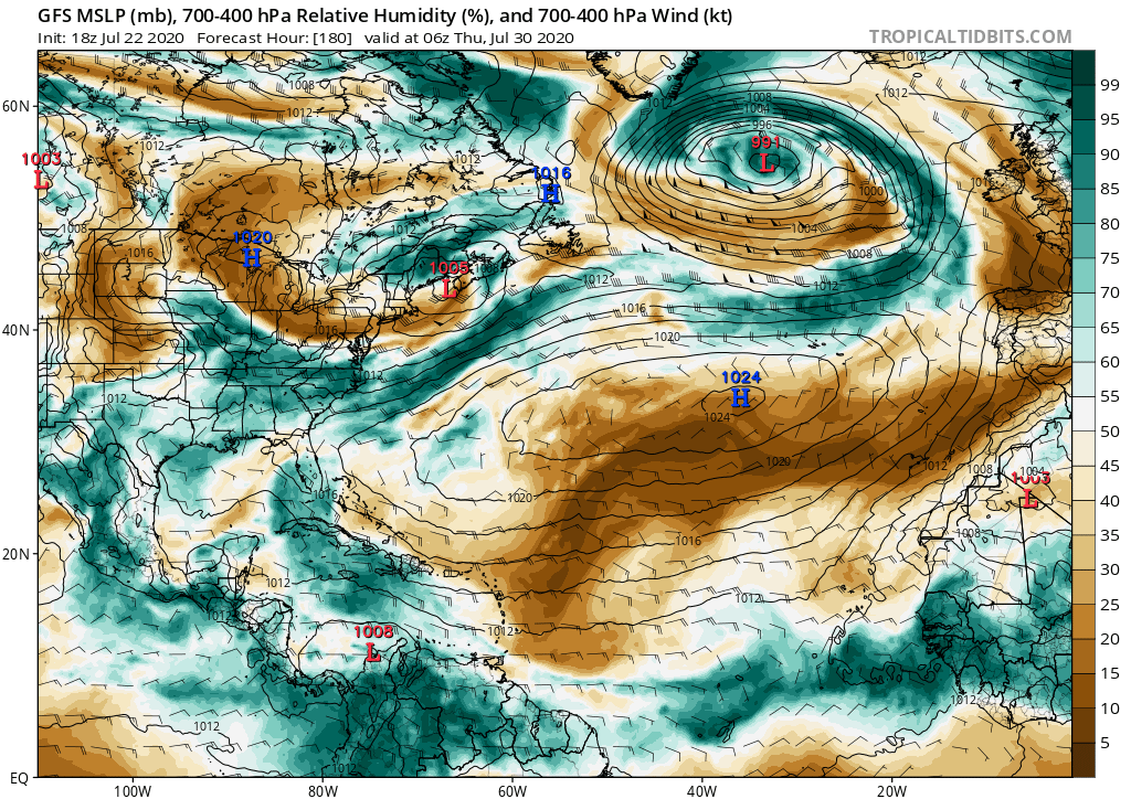
Euro hates Gonzalo but really loves the wave behind it.
6 likes
-
CyclonicFury

- Category 5
- Posts: 2033
- Age: 27
- Joined: Sun Jul 02, 2017 12:32 pm
- Location: NC
- Contact:
Re: 2020 Global Model Runs Discussion (Out thru day 16)
supercane4867 wrote:Euro hates Gonzalo but really loves the wave behind it.
https://i.imgur.com/ZBUnEOn.gif
Some members are developing the wave behind that one too. August looks like it could be much more favorable than the last two years.
4 likes
NCSU B.S. in Meteorology Class of 2021. Tropical weather blogger at http://www.cyclonicfury.com. My forecasts and thoughts are NOT official, for official forecasts please consult the National Hurricane Center.
-
OuterBanker
- S2K Supporter

- Posts: 1761
- Joined: Wed Feb 26, 2003 10:53 am
- Location: Nags Head, NC
- Contact:
Re: 2020 Global Model Runs Discussion (Out thru day 16)
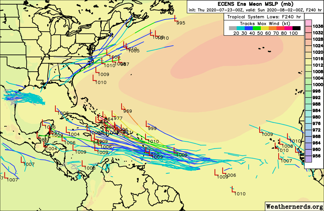
supercane4867 wrote:Euro hates Gonzalo but really loves the wave behind it.
https://i.imgur.com/ZBUnEOn.gif
That model is really not good.
CMC also has a storm north of the islands.
What are both seeing?
0 likes
-
SFLcane

- S2K Supporter
- Posts: 10281
- Age: 48
- Joined: Sat Jun 05, 2010 1:44 pm
- Location: Lake Worth Florida
Re: 2020 Global Model Runs Discussion (Out thru day 16)
OuterBanker wrote:supercane4867 wrote:Euro hates Gonzalo but really loves the wave behind it.
https://i.imgur.com/ZBUnEOn.gif
That model is really not good.
CMC also has a storm north of the islands.
What are both seeing?
Wave emerging of African coast soon.
0 likes
-
SconnieCane
- Category 5
- Posts: 1013
- Joined: Thu Aug 02, 2018 5:29 pm
- Location: Madison, WI
Re: 2020 Global Model Runs Discussion (Out thru day 16)
supercane4867 wrote:Euro hates Gonzalo but really loves the wave behind it.
https://i.imgur.com/ZBUnEOn.gif
Am I seeing things or are the majority of those members depicting U.S. landfalls of some sort, anywhere from South Florida to Cape Cod?
That's extraordinary for a wave that hasn't even come off Africa yet, and we're only about 3/4 of the way through July.
4 likes
-
TheStormExpert
Re: 2020 Global Model Runs Discussion (Out thru day 16)
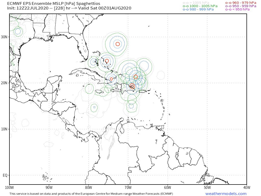
caneseddy wrote:SFLcane wrote:12z EPS not done yet tracking towards Bahamas and VERY active. Irma vibes last few runs
https://iili.io/dxyxzg.jpg
Almost identical to the CMC 12z run with that potential hurricane approaching Bahamas
If this verifies and right now it has support from the CMC then this would be the dreaded “I” storm (assuming 91L develops)
Not an official forecast
I been having bad vibes with Isaias since before the season started!

3 likes

Re: 2020 Global Model Runs Discussion (Out thru day 16)
supercane4867 wrote:Euro hates Gonzalo but really loves the wave behind it.
https://i.imgur.com/ZBUnEOn.gif
I see a <960 mbar major hurricane making landfall in Long Island/Connecticut.
How about no, please?
1 likes
Irene '11 Sandy '12 Hermine '16 5/15/2018 Derecho Fay '20 Isaias '20 Elsa '21 Henri '21 Ida '21
I am only a meteorology enthusiast who knows a decent amount about tropical cyclones. Look to the professional mets, the NHC, or your local weather office for the best information.
I am only a meteorology enthusiast who knows a decent amount about tropical cyclones. Look to the professional mets, the NHC, or your local weather office for the best information.
-
OuterBanker
- S2K Supporter
- Posts: 1761
- Joined: Wed Feb 26, 2003 10:53 am
- Location: Nags Head, NC
- Contact:
Re: 2020 Global Model Runs Discussion (Out thru day 16)
I thought that the large system that exited the African continent yesterday around 15n would amount to something. But,it went poof.
But in the process it seems to have moistened the atmosphere in the process so anything following it will have a better chance.
But in the process it seems to have moistened the atmosphere in the process so anything following it will have a better chance.
0 likes
-
gatorcane

- S2K Supporter
- Posts: 23708
- Age: 48
- Joined: Sun Mar 13, 2005 3:54 pm
- Location: Boca Raton, FL
Re: 2020 Global Model Runs Discussion (Out thru day 16)
HurricaneFrances04 wrote:There's the July everyone needed to see for a hyperactive season. Looks like the lid is coming off a month earlier than normal.
I don’t see that the lid is coming off yet. Yes we have a couple of systems but as has been the case so far, we are seeing weak (and tiny Gonzalo) systems and nothing significant like 2005 had by now for example. Climatology does suggest we are on a slow and steady rise in activity as we head towards end of July. Watch for the bigger increase as we head into mid August in a few weeks. Models will be popping soon even the very stubborn GFS.
Speaking of the GFS, plenty of dry air around still as we look a week out, not as much as a week ago but not quite there yet:
0 likes
-
Hurricaneman

- Category 5
- Posts: 7404
- Age: 45
- Joined: Tue Aug 31, 2004 3:24 pm
- Location: central florida
Re: 2020 Global Model Runs Discussion (Out thru day 16)
supercane4867 wrote:Euro hates Gonzalo but really loves the wave behind it.
https://i.imgur.com/ZBUnEOn.gif
The 0zGFS does nothing with this, unlike the Euro, and the reason is it has that wave moving too fast to develop while the Euro is slower which allows for development
Looking at both the 0zGFS has the wave near Puerto Rico while the Euro has it just east of the Caribbean in the same timeframe and that 500+ miles difference is important
0 likes
-
SFLcane
- S2K Supporter
- Posts: 10281
- Age: 48
- Joined: Sat Jun 05, 2010 1:44 pm
- Location: Lake Worth Florida
Re: 2020 Global Model Runs Discussion (Out thru day 16)
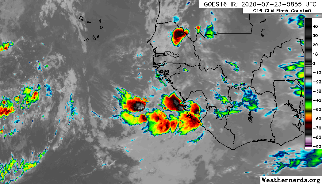
Overnight EPS very active with wave emerging of the African coast. One to watch for sure.
0 likes
-
gatorcane
- S2K Supporter
- Posts: 23708
- Age: 48
- Joined: Sun Mar 13, 2005 3:54 pm
- Location: Boca Raton, FL
Re: 2020 Global Model Runs Discussion (Out thru day 16)
SFLcane wrote:Overnight EPS very active with wave emerging of the African coast. One to watch for sure.
https://iili.io/dzGSef.png
I remain skeptical. Still not one GFS ensemble develops, the CMC has backed off as well. Could be that the upgraded Euro develops more phantoms in the long-range (as we have seen in the EPAC) but the model still looks solid for tracking a storm once it develops as it is nailing Gonzalo. We know the SAL that is wreaking havoc on Gonzalo is still blanketing the MDR and is not going anywhere anytime soon.
3 likes
-
SFLcane
- S2K Supporter
- Posts: 10281
- Age: 48
- Joined: Sat Jun 05, 2010 1:44 pm
- Location: Lake Worth Florida
Re: 2020 Global Model Runs Discussion (Out thru day 16)
SFLcane wrote:Overnight EPS very active with wave emerging of the African coast. One to watch for sure.
https://iili.io/dzGSef.png
Here is wave of the African coast quite impressive.
4 likes
-
toad strangler

- S2K Supporter
- Posts: 4546
- Joined: Sun Jul 28, 2013 3:09 pm
- Location: Earth
- Contact:
Re: 2020 Global Model Runs Discussion (Out thru day 16)
gatorcane wrote:SFLcane wrote:Overnight EPS very active with wave emerging of the African coast. One to watch for sure.
https://iili.io/dzGSef.png
I remain skeptical. Still not one GFS ensemble develops, the CMC has backed off as well. Could be that the upgraded Euro develops more phantoms in the long-range (as we have seen in the EPAC) but the model still looks solid for tracking a storm once it develops as it is nailing Gonzalo. We know the SAL that is wreaking havoc on Gonzalo is still blanketing the MDR and is not going anywhere anytime soon.
Doesn't matter if Gonzalo goes poof. It's an MDR storm that popped up nearly out of nowhere because the models whiffed (sans CMC). It's a TC that showed up in a poor environment and background state a nearly a month before it should have. THAT's a signal in my eyes.
9 likes
My Weather Station
https://www.wunderground.com/dashboard/pws/KFLPORTS603
https://www.wunderground.com/dashboard/pws/KFLPORTS603

Re: 2020 Global Model Runs Discussion (Out thru day 16)
toad strangler wrote:Doesn't matter if Gonzalo goes poof. It's an MDR storm that popped up nearly out of nowhere because the models whiffed (sans CMC). It's a TC that showed up in a poor environment and background state a nearly a month before it should have. THAT's a signal in my eyes.
The models, even though they have been missing are starting to show activity in the weeks ahead.
The other signals are there too, I expect a very busy August.
0 likes
-
cycloneye

- Admin

- Posts: 149438
- Age: 69
- Joined: Thu Oct 10, 2002 10:54 am
- Location: San Juan, Puerto Rico
Re: 2020 Global Model Runs Discussion (Out thru day 16)
A thread for the wave that some models develop is now available so you can post the model runs there.
viewtopic.php?f=31&t=121043&p=2814412#p2814412
viewtopic.php?f=31&t=121043&p=2814412#p2814412
0 likes
Visit the Caribbean-Central America Weather Thread where you can find at first post web cams,radars
and observations from Caribbean basin members Click Here
and observations from Caribbean basin members Click Here
-
TheStormExpert
Re: 2020 Global Model Runs Discussion (Out thru day 16)
gatorcane wrote:SFLcane wrote:Overnight EPS very active with wave emerging of the African coast. One to watch for sure.
https://iili.io/dzGSef.png
I remain skeptical. Still not one GFS ensemble develops, the CMC has backed off as well. Could be that the upgraded Euro develops more phantoms in the long-range (as we have seen in the EPAC) but the model still looks solid for tracking a storm once it develops as it is nailing Gonzalo. We know the SAL that is wreaking havoc on Gonzalo is still blanketing the MDR and is not going anywhere anytime soon.
I’m with you too gatorcane! Seeing that Gonzalo didn’t last more than a few days as an impressive entity due to all the SAL and mid-level dry air has me really skeptical of this developing as the Euro and the CMC are basically it. Not to mention I keep noticing the Euro is slowly delaying or pushing back development of this area. Things will likely ramp up some but not for a month or so.
1 likes
-
Ivanhater

- Storm2k Moderator

- Posts: 11221
- Age: 39
- Joined: Fri Jul 01, 2005 8:25 am
- Location: Pensacola
Re: 2020 Global Model Runs Discussion (Out thru day 16)
I'm not sure exactly what the catalyst is but quite a few models are showing another spin up in the Gulf behind future Hannah, early next week. Icon, Cmc, Ukmet


Sent from my SM-G955U using Tapatalk
Sent from my SM-G955U using Tapatalk
0 likes
Michael
-
EquusStorm
- Category 5
- Posts: 1649
- Age: 35
- Joined: Thu Nov 07, 2013 1:04 pm
- Location: Jasper, AL
- Contact:
Re: 2020 Global Model Runs Discussion (Out thru day 16)
Watch that little Gulf spinup snipe the 'I' name like Imelda did last year lol
1 likes
Colors of lost purpose on the canvas of irrelevance
Not a meteorologist, in fact more of an idiot than anything. You should probably check with the NHC or a local NWS office for official information.
Not a meteorologist, in fact more of an idiot than anything. You should probably check with the NHC or a local NWS office for official information.
-
TheProfessor

- Professional-Met

- Posts: 3506
- Age: 29
- Joined: Tue Dec 03, 2013 10:56 am
- Location: Wichita, Kansas
Re: 2020 Global Model Runs Discussion (Out thru day 16)
Ivanhater wrote:I'm not sure exactly what the catalyst is but quite a few models are showing another spin up in the Gulf behind future Hannah, early next week. Icon, Cmc, Ukmethttps://uploads.tapatalk-cdn.com/20200723/96060e947f7a1d59cd492b1535a695b5.jpg https://uploads.tapatalk-cdn.com/20200723/9bba7ead4287e9addff7d8f693d2fd74.jpg https://uploads.tapatalk-cdn.com/20200723/ca14494e8e0874d68801cd68ee2cb3ad.jpg
Sent from my SM-G955U using Tapatalk
Steve has been alluding to this. Meanwhile here's yesterday's 6z Parallel GFS that just came out.

Part of me want to attribute this to convective feedback(especially in the case above) but multiple models falling prey to that would be weird. Definitely something interesting and any leftover energy will need to be watched.
0 likes
An alumnus of The Ohio State University.
Your local National Weather Service office is your best source for weather information.
Your local National Weather Service office is your best source for weather information.
Who is online
Users browsing this forum: Google [Bot] and 278 guests