Impressive blob SE of Hawaii
Moderator: S2k Moderators
Forum rules

The posts in this forum are NOT official forecasts and should not be used as such. They are just the opinion of the poster and may or may not be backed by sound meteorological data. They are NOT endorsed by any professional institution or STORM2K. For official information, please refer to products from the National Hurricane Center and National Weather Service.
-
brunota2003

- S2K Supporter

- Posts: 9476
- Age: 35
- Joined: Sat Jul 30, 2005 9:56 pm
- Location: Stanton, KY...formerly Havelock, NC
- Contact:
Central Pacific (140W to 180) xml button
400 AM HST SAT JUN 6 2009
FOR THE CENTRAL NORTH PACIFIC...BETWEEN 140W AND 180
No tropical cyclones are expected through early Monday morning.
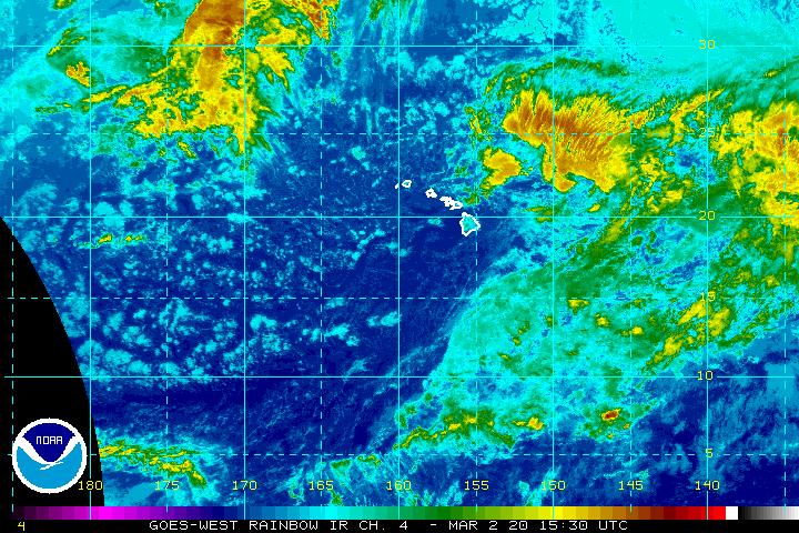
Most of it is below 10N too, so wouldn't expect too much with that shear. Impressive looking blob nonetheless, however.
400 AM HST SAT JUN 6 2009
FOR THE CENTRAL NORTH PACIFIC...BETWEEN 140W AND 180
No tropical cyclones are expected through early Monday morning.
Most of it is below 10N too, so wouldn't expect too much with that shear. Impressive looking blob nonetheless, however.
0 likes


Nothing more than regular ITCZ.
ATHW40 PHFO 070034
SIMHI
HAWAIIAN ISLANDS SATELLITE INTERPRETATION MESSAGE
NWS CENTRAL PACIFIC HURRICANE CENTER HONOLULU HI
0030 UTC SUN JUN 7 2009
BASED ON DATA THROUGH 0000 UTC JUNE 7 2009
A BROAD FIELD OF SCATTERED TO BROKEN AND RATHER STABLE LOOKING
STRATOCUMULUS CLOUDS ARE SEEN MOVING WESTWARD IN MODERATE TRADE WIND
FLOW. THIS IS BASICALLY PROVIDING A TYPICAL CLOUD DISTRIBUTION OVER
THE ISLANDS PRIMARILY OVER WINDWARD AND MAUKA AREAS.
OVER KAUAI THE VAST MAJORITY OF CLOUD COVER WAS OVER INTERIOR
SECTIONS. OVER OAHU LOW CLOUDS ARE BANKED UP OVER THE SLOPES AND
SUMMITS OF THE KOOLAU RANGE WITH GENERALLY SCATTERED LOW CLOUDS SEEN
ELSEWHERE. OVER MOLOKAI LOW CLOUDS ARE MAINLY OVER THE EASTERN THIRD
OF THE ISLAND AS WELL AS OVER SOUTHWEST COASTAL SECTIONS. OVER LANAI
LOW CLOUDS ARE MAINLY OVER INTERIOR SECTIONS. OVER MAUI LOW CLOUDS
ARE BANKED UP OVER THE SLOPES OF HALEAKALA AS WELL AS OVER THE
SLOPES AND SUMMITS OF THE WEST MAUI MOUNTAINS. OVER THE BIG ISLAND
LOW CLOUDS ARE BANKED UP OVER THE WINDWARD SLOPES FROM NORTH KOHALA
SOUTHWARD THROUGH THE HILO AND PUNA DISTRICTS. LOW CLOUDS ARE ALSO
PRESENT OVER THE SOUTHEAST KAU SLOPES. DAYTIME HEATING HAS CAUSED AN
ABUNDANT AMOUNT OF LOW CLOUDS TO FORM OVER THE KONA SLOPES.
DOWN IN THE DEEP TROPICS ALONG WHAT IS COMMONLY REFERRED TO AS THE
INTERTROPICAL CONVERGENCE ZONE ARE TWO DISTINCT AREAS OF ACTIVE
TOWERING CUMULUS AND ISOLATED CUMULONIMBUS CLOUDS. THE FIRST AREA
FAR TO THE SOUTHEAST OF THE STATE LIES IN AN AREA FROM 06N AND 12N
BETWEEN 140W AND 150W WHILE THE SECOND AREA FAR TO THE SOUTH
SOUTHWEST OF THE STATE LIES IN AN AREA FROM 08N TO 12N BETWEEN 164W
AND 170W. BOTH OF THESE AREAS ARE GENERALLY MOVING TOWARD THE WEST
AT AROUND 10 MPH. CLOUD TOPS HAVE WARMED OVER THE PAST SEVERAL HOURS
WITH TOPS ESTIMATED TO BE UP TO AROUND 48000 FEET.
$$
BURKE
0 likes
Who is online
Users browsing this forum: No registered users and 70 guests