SUPER TYPHOON NIDA (26W) MOST INTENSE IN 10 YEARS

This is the general tropical discussion area. Anyone can take their shot at predicting a storms path.

Moderator: S2k Moderators

Forum rules

The posts in this forum are NOT official forecasts and should not be used as such. They are just the opinion of the poster and may or may not be backed by sound meteorological data. They are NOT endorsed by any professional institution or STORM2K. For official information, please refer to products from the National Hurricane Center and National Weather Service.

Help Support Storm2K
Message
Author
weathergaines
Tropical Wave
Tropical Wave
Posts: 5
Joined: Mon Nov 16, 2009 2:14 am
Location: Manila, Philippines
Contact:

SUPER TYPHOON NIDA (26W) MOST INTENSE IN 10 YEARS

#1 Postby weathergaines » Thu Nov 26, 2009 3:42 am

Imagine a bullet train crossing at your path or a jet flying near your place, that's what it look like when super typhoon nida (26w) cross your path after reaching a most intense wind of 160kt and gust of 195kt (296kph-361kph)

Image
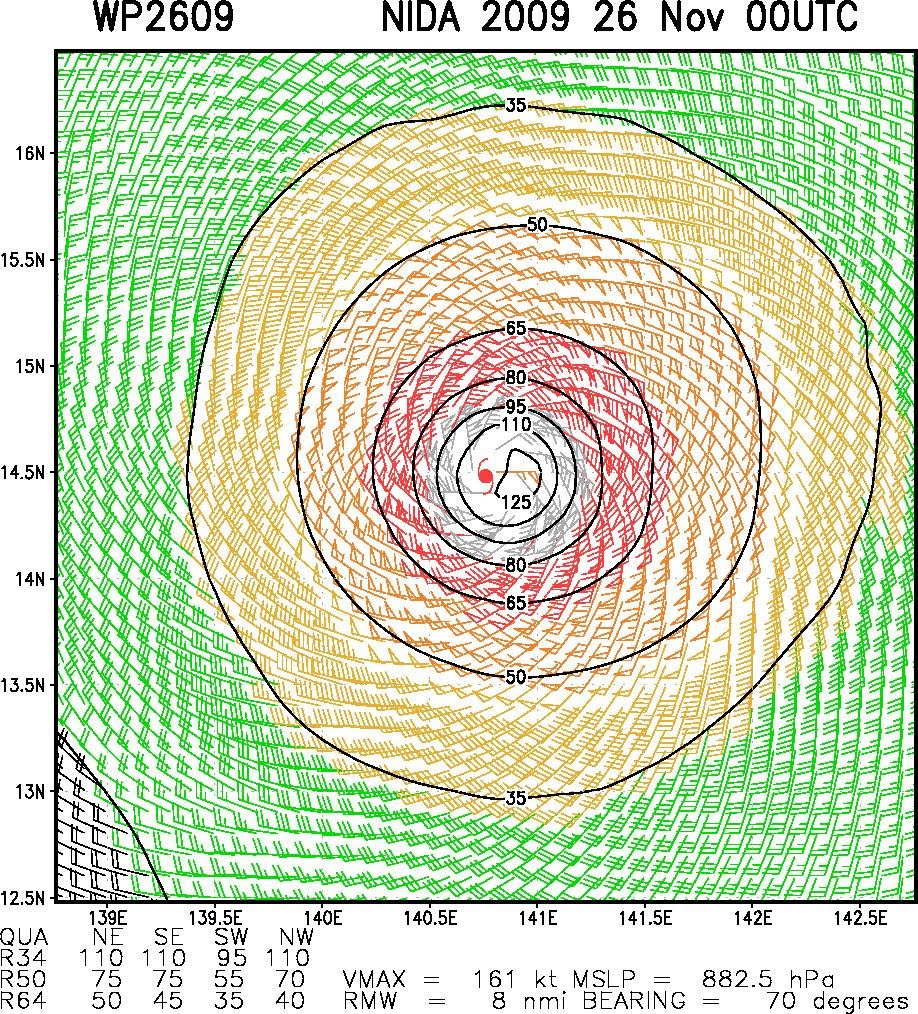
. Thanks God that no landmass or populated areas ever cross this Super typhoon that can destroy simultaneously every structure along it paths and even can trigger a 20m height or more waves along the coast.
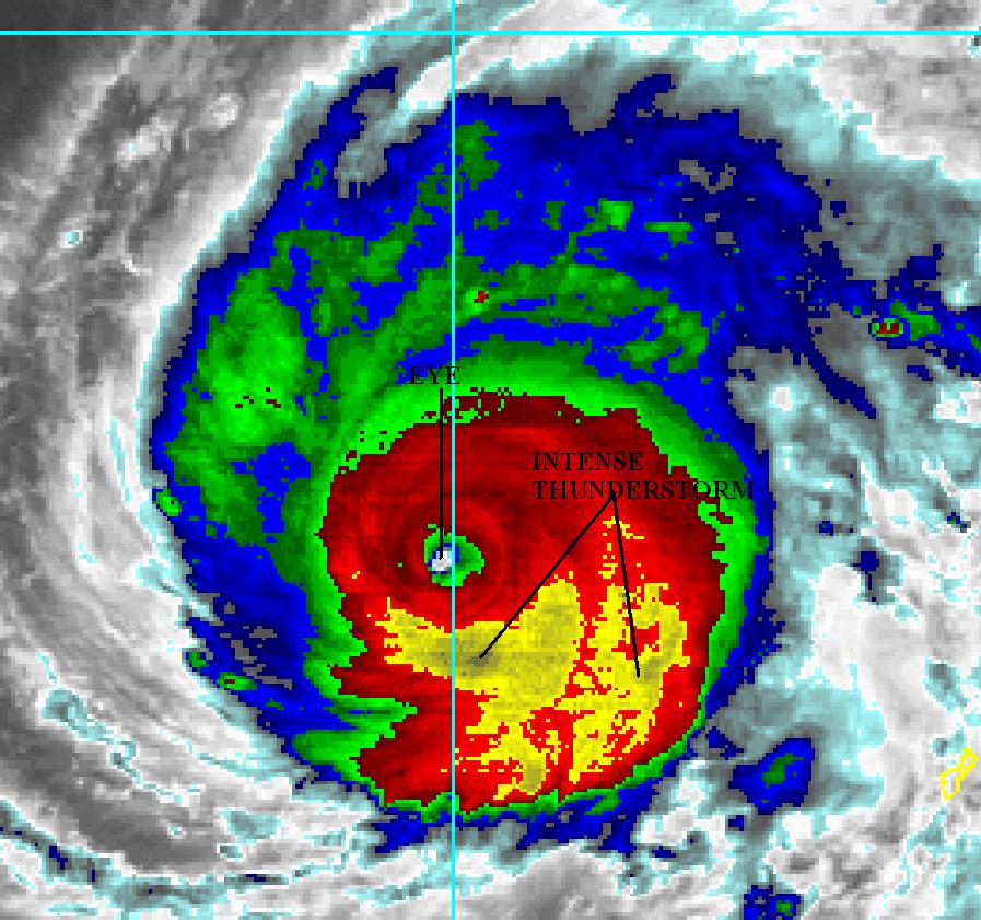
Image.

Thermal IR imagery shows how intense the thunderstorm clouds along its inner band (even hot towers) which i believe contributes mainly to its intense strength supported by weak shear along the path and also warmer 29-30C SST.
Now it moves more to the north, it is more likely to rapidly weakens as stronger vertical windshear and colder SST envelops along the area.
0 likes   

Typhoon Hunter
WesternPacificWeather.com
Posts: 1221
Joined: Wed Oct 11, 2006 11:37 am
Location: Tokyo
Contact:

Re: SUPER TYPHOON NIDA (26W) MOST INTENSE IN 10 YEARS

#2 Postby Typhoon Hunter » Thu Nov 26, 2009 6:23 am

Officially no, Nida was equal in strength to Typhoon Jangmi last year according to RSMC Tokyo.

I personally feel Nida was stronger than Jangmi and it was impressive to see JTWC give it 160kts - a rare occurrence!
0 likes   
James - Documenting tropical cyclones...

http://www.youtube.com/TyphoonHunter

User avatar
Iune
Category 1
Category 1
Posts: 291
Joined: Mon Aug 04, 2008 12:23 pm
Location: New York City

Re: SUPER TYPHOON NIDA (26W) MOST INTENSE IN 10 YEARS

#3 Postby Iune » Thu Nov 26, 2009 10:27 am

Nida and Jangmi both had 130 mph and 905 hPa by JMA which makes them the strongest since Zeb in 1998, it had 900 hPa.
0 likes   
Floyd 1999 · Irene 2011 · Sandy 2012

User avatar
Aslkahuna
Professional-Met
Professional-Met
Posts: 4550
Joined: Thu Feb 06, 2003 5:00 pm
Location: Tucson, AZ
Contact:

Re: SUPER TYPHOON NIDA (26W) MOST INTENSE IN 10 YEARS

#4 Postby Aslkahuna » Fri Nov 27, 2009 4:56 pm

All estimated pressures of course since there's no in situ recon out there.

Steve
0 likes   

pojo
Military Member
Military Member
Posts: 8016
Age: 43
Joined: Thu Feb 06, 2003 9:16 pm
Location: Houston

Re: SUPER TYPHOON NIDA (26W) MOST INTENSE IN 10 YEARS

#5 Postby pojo » Tue Dec 22, 2009 9:32 pm

Recon actually flew STY Jangmi; first STY since the Typhoon Chasers left Guam. They recorded a stadium effect and Cat 5.
0 likes   


Return to “Talkin' Tropics”

Who is online

Users browsing this forum: Blown Away, Cpv17, gib, StormWeather and 85 guests