The CMC was excellent in the handling of Andrea. While both the GFS and the Euro had Andrea as a right weighted storm at landfall and beyond a couple days before landfall, the Canadian had her more symmetric with a left weighed rain event which ultimately proved to be right. I know that they made improvements this year but it’s hard to believe it improved that much. The CMC is mostly regarded as a curiosity and tends to spin up just about everything, but not taken too seriously. My question is was it just a fluke that it handled Andrea that well or was the upgrade responsible? Was it the only model that saw the interaction with the trough or was it lucky? Only time will tell, but maybe it’s time to take a second look at the CMC. I like to give credit where credit is due. Who knows, maybe we all will be learning the words to “O Canada” before the season is over.
PS What the heck happened with the GFDL? It was so bad it was embarrassing. Several hundred miles off any other model.
Canadian Coup?
Moderator: S2k Moderators
Forum rules

The posts in this forum are NOT official forecasts and should not be used as such. They are just the opinion of the poster and may or may not be backed by sound meteorological data. They are NOT endorsed by any professional institution or STORM2K. For official information, please refer to products from the National Hurricane Center and National Weather Service.
-
OuterBanker
- S2K Supporter

- Posts: 1761
- Joined: Wed Feb 26, 2003 10:53 am
- Location: Nags Head, NC
- Contact:
Canadian Coup?
0 likes
-
gatorcane

- S2K Supporter
- Posts: 23703
- Age: 47
- Joined: Sun Mar 13, 2005 3:54 pm
- Location: Boca Raton, FL
The CMC was still spinning up some phantom systems about 7-10 days prior to Andrea forming.
It spun up something in the Southwest Caribbean and also tried to develop some kind of system near the FL straits from an eastward moving trough.
The CMC also forecasted Andrea to be far stronger than it ever got but it did better than the GFS in that it didn't show lows splitting.
That said, it was the first model to show development of the first EPAC system of 2013.
I am curious how the CMC does the rest of the season by my bets are that the GFS will end up performing much better.
0 likes
-
wxman57

- Moderator-Pro Met

- Posts: 23120
- Age: 68
- Joined: Sat Jun 21, 2003 8:06 pm
- Location: Houston, TX (southwest)
Re: Canadian Coup?
Canadian develops everything (and nothing) into strong systems. Of course it's going to be "right" occasionally. Even a broken clock is right twice a day (analog clock). Once it stops developing everything and gets a few development forecasts right then I'll start to pay closer attention to it. Generally, though, far too many spurious developments.
0 likes

Re: Canadian Coup?
The Canadian just lucked out with Andrea, IMO, prior to Andrea forming it was forecasting numerous ghost storms underneath the trough of low pressure near FL.
0 likes

Re: Canadian Coup?
still though it is 10X better than the NAVGEM and it has been upgraded. I seem to remember the CMC was sniffing the BOC before the GFS was coming up at the end of the month. Currently it developes a system in the EPAC whereas the GFS keeps it in the BOC. I would not discount the CMC this year. It is already one for one this year with Andrea.
0 likes
-
TropicalAnalystwx13

- Category 5

- Posts: 2109
- Age: 28
- Joined: Tue Jul 19, 2011 8:20 pm
- Location: Wilmington, NC
- Contact:
Luck has nothing to do with its performance IMO. Ever since its upgrade in the late winter, the CMC has consistently been one of the best for mid- and upper latitude forecasting.
In the tropics, it was the first to nail the development of twin cyclones in the Indian Ocean. Granted, one run it did show the southern hemisphere one crossing into the NHEM, but...as said..it was just one run.
It was the first to show the development of Tropical Storm Alvin, several days before the GFS picked up on it. It was also the less bullish and the farthest west. While the GFS intensified it into a hurricane and sent it north towards Baja California, the CMC peaked it as a moderate tropical storm at best and sent it west under the southeastern periphery of the large subtropical ridge across the Pacific at the time.
It was the first to show the development AND track of Hurricane Barbara. Intensity was a bit shaky, with the model flipping from a tropical depression making landfall to a Category 1 hurricane making landfall (due to fluctuating proximities to the coast), but it soon settled on the latter.
While the GFS showed Andrea as a very elongated area of low pressure/weak tropical depression moving into Florida, the CMC showed it as a consolidated 988-992 millibar tropical cyclone moving into the Florida Panhandle. And it hardly deviated from this.
I've not seen much in the way of ghost storms. It did briefly show a subtropical cyclone off the Southeast coastline around this time, but dropped it a few days ago.
Gotta give credit where credit is due. I used to hate the CMC, but it's become a good model for now. Makes me wonder how the HWRF is going to perform. Is supposed to rival the GFS in track and surpass the NHC and statistical models in intensity forecasting after its upgrade on July 16 according to NOAA.
0 likes
-
TropicalAnalystwx13
- Category 5
- Posts: 2109
- Age: 28
- Joined: Tue Jul 19, 2011 8:20 pm
- Location: Wilmington, NC
- Contact:
Re:
NDG wrote:It might have imoproved some, I do admit, but you guys forgot that it was the only model that erroneously was developing 92L, while the GFS was not which it proved to be right.
For all intents and purposes, 92L was a tropical depression, if not a tropical storm. The NHC doesn't like naming storms that are unlikely to last long in the pre-season. Happened with 2010's 92L as well.
0 likes
Re: Canadian Coup?
0 likes

Re: Re:
TropicalAnalystwx13 wrote:NDG wrote:It might have imoproved some, I do admit, but you guys forgot that it was the only model that erroneously was developing 92L, while the GFS was not which it proved to be right.
For all intents and purposes, 92L was a tropical depression, if not a tropical storm. The NHC doesn't like naming storms that are unlikely to last long in the pre-season. Happened with 2010's 92L as well.
Might be added post season if it is a tropical storm.
0 likes
Re: Canadian Coup?
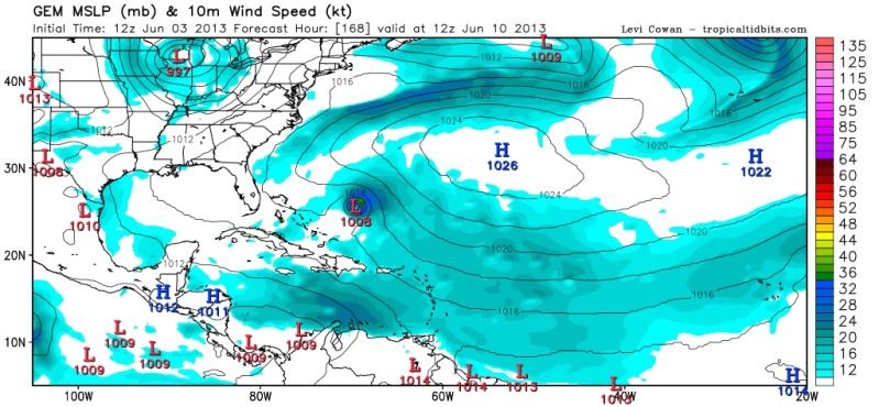
This is what I was talking about regarding the model and 92L.
It's medium to long range forecast still sucks, IMO.
It's medium to long range forecast still sucks, IMO.
Last edited by NDG on Fri Jun 14, 2013 7:52 am, edited 1 time in total.
0 likes
-
AJC3

- Admin

- Posts: 4152
- Age: 62
- Joined: Tue Aug 31, 2004 7:04 pm
- Location: Ballston Spa, New York
- Contact:
Historically, the CMC GEM has been the best-performing model in scenarios when other models failed to spin up, or underdid the intensity, of a system. That's naturally the case because of its statistical bias toward spinning up/intensifying systems. It remains to be seen whether or not the recent model upgrade will help keep this bias in check.
From an anecdotal (personal) perspective, the CMC doesn't seem as horrifically bad with phantom spin-ups as it used to be, but I don't have any solid stats or studies to go by.
From an anecdotal (personal) perspective, the CMC doesn't seem as horrifically bad with phantom spin-ups as it used to be, but I don't have any solid stats or studies to go by.
0 likes


The CMC has gotten better than it was before IMO since the upgrade. Now this doesn't mean it's on the skill level as the GFS or Euro, but it has become a much less erratic model. It has some struggles with making features too strong at times but overall has a better idea than it's predecessor. Best to use the newly improved Canadian as a reference comparison to the other two as a supplement rather than standalone guidance until we know for sure it is highly reliable, which will take more than a few months that has passed since.
0 likes
The above post and any post by Ntxw is NOT an official forecast and should not be used as such. It is just the opinion of the poster and may or may not be backed by sound meteorological data. It is NOT endorsed by any professional institution including Storm2k. For official information, please refer to NWS products.
Help support Storm2K!
Re: Canadian Coup?
ROCK wrote:still though it is 10X better than the NAVGEM and it has been upgraded. I seem to remember the CMC was sniffing the BOC before the GFS was coming up at the end of the month. Currently it developes a system in the EPAC whereas the GFS keeps it in the BOC. I would not discount the CMC this year. It is already one for one this year with Andrea.
Well, what you have to say about the CMC now that it failed misserable with TD 2?
0 likes
Who is online
Users browsing this forum: No registered users and 76 guests