Texas Fall 2018
Moderator: S2k Moderators
Forum rules

The posts in this forum are NOT official forecast and should not be used as such. They are just the opinion of the poster and may or may not be backed by sound meteorological data. They are NOT endorsed by any professional institution or STORM2K.
Re: Texas Fall 2018
Also, after further contemplation; this event isn't over yet probably. And what may be unprecedented-may be-is that we had the major feeders for the three basins: Buchanan, LBJ, and Travis all in flood stage at the same time. ONe thing definitely different from previous is the immediate availability of real time data.
1 likes
-
Haris

- Category 5

- Posts: 1808
- Joined: Mon Nov 27, 2017 8:19 pm
- Location: ( Bee Cave) West Austin, Texas
Re: Texas Fall 2018
NAM shows 9" just W of LT next 48 hours
Better hope that is wrong.
Better hope that is wrong.
0 likes
Weather geek and a storm spotter in West Austin. Not a degreed meteorologist. Big snow fan. Love rain and cold! Despise heat!
-
bubba hotep

- S2K Supporter

- Posts: 5476
- Joined: Wed Dec 28, 2016 1:00 am
- Location: Collin County Texas
Re: Texas Fall 2018
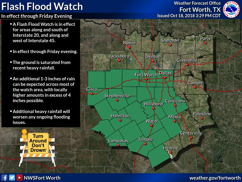
Another Flash Flood Watch for DFW, they might need to extend it a county or so NE based on the Euro and 18z GFS
0 likes
Winter time post are almost exclusively focused on the DFW area.

Re: Texas Fall 2018
bubba hotep wrote:Another Flash Flood Watch for DFW, they might need to extend it a county or so NE based on the Euro and 18z GFS
https://pbs.twimg.com/media/Dp0VKQ9UwAADzyW.jpg
The flash flood watches feels like 2015. Taken down just to be put right back up.
2 likes
The above post and any post by Ntxw is NOT an official forecast and should not be used as such. It is just the opinion of the poster and may or may not be backed by sound meteorological data. It is NOT endorsed by any professional institution including Storm2k. For official information, please refer to NWS products.
Help support Storm2K!
-
Brent
- S2K Supporter
- Posts: 37111
- Age: 35
- Joined: Sun May 16, 2004 10:30 pm
- Location: Tulsa Oklahoma
- Contact:
Re: Texas Fall 2018
Ntxw wrote:bubba hotep wrote:Another Flash Flood Watch for DFW, they might need to extend it a county or so NE based on the Euro and 18z GFS
https://pbs.twimg.com/media/Dp0VKQ9UwAADzyW.jpg
The flash flood watches feels like 2015. Taken down just to be put right back up.
already expecting another one next week
1 likes
#neversummer
-
weatherdude1108
- Category 5
- Posts: 4172
- Joined: Tue Dec 13, 2011 1:04 pm
- Location: Northwest Austin/Cedar Park, TX
Re: Texas Fall 2018
utpmg wrote:I haven't heard anyone who's been around here as long as I have call it "unprecedented." My family has certainly seen it this high a few times in the past. But I believe they've only recently redefined some of the flood plain scenarios. Specifically, the possible height over the spillway the water could be.
Yeah, it's people who have moved here since the previous major floods, who I hear say it.
Guess it's like someone moving to Kansas for the first time (Tornado Alley) and experiencing his or her first tornado. Not the same natural disaster, but anyway.
0 likes
The preceding post is NOT an official forecast, and should not be used as such. It is only the opinion of the poster and may or may not be backed by sound meteorological data. It is NOT endorsed by any professional institution including storm2k.org. For Official Information please refer to the NHC and NWS products.
-
bubba hotep
- S2K Supporter
- Posts: 5476
- Joined: Wed Dec 28, 2016 1:00 am
- Location: Collin County Texas
Re: Texas Fall 2018
00z 3k NAM supports the thinking that the Flash Flood Watch could be expanded to include Collin, Rockwall and Kaufman counties.
0 likes
Winter time post are almost exclusively focused on the DFW area.
-
weatherdude1108
- Category 5
- Posts: 4172
- Joined: Tue Dec 13, 2011 1:04 pm
- Location: Northwest Austin/Cedar Park, TX
Re: Texas Fall 2018
I remember driving back on Christmas break 1991 from Lubbock to SA, seeing waterfalls cascading down the road cuts and cliffs in the hill country, everywhere you looked. It was a surreal scene!
https://twitter.com/MarkMurrayATX/statu ... 38945?s=20
https://twitter.com/MarkMurrayATX/statu ... 38945?s=20
2 likes
The preceding post is NOT an official forecast, and should not be used as such. It is only the opinion of the poster and may or may not be backed by sound meteorological data. It is NOT endorsed by any professional institution including storm2k.org. For Official Information please refer to the NHC and NWS products.
-
bubba hotep
- S2K Supporter
- Posts: 5476
- Joined: Wed Dec 28, 2016 1:00 am
- Location: Collin County Texas
Re: Texas Fall 2018

Mesoscale Precipitation Discussion 0990
NWS Weather Prediction Center College Park MD
847 AM EDT Fri Oct 19 2018
Areas affected...Central to Northeast TX
Concerning...Heavy rainfall...Flash flooding possible
Valid 191246Z - 191846Z
Summary...An increase in hourly rain totals to 0.5"+ with local
amounts of 1-2" expected during the next several hours over
saturated soils, which would enhance flooding across a saturated
region.
Discussion...Water vapor imagery shows a shortwave moving
northeast through the TX Panhandle at this time. Infrared imagery
reveals a slow cloud top cooling across the region during the past
few hours to the northwest of an inverted trough extending north
from an area of low pressure just offshore the TX coast, which is
leading to a slow increase in hourly rain totals/rates.
Precipitable water values are ~1.75" per recent GPS data. Inflow
at 850 hPa is slightly convergent out of the south-southwest at
20-25 kts per VAD wind profiles, which is importing MU CAPE values
of 100-500 J/kg into the region.
The 06z HREF probabilities of 0.5" an hour are forecast come up in
this area, exceeding 50% in a spotty manner through 19z. This
fits the available moisture and MU CAPE, which should be able to
support 0.5" an hour rates from any showers and thunderstorms that
form in this environment. The mesoscale guidance indicates the
potential for 1-2" of rain during the next six hours. Despite a
slow upward return in flash flood guidance values, two week
precipitation anomalies are 600%+ of average, which implies
significant soil saturation. Discussions with the local forecast
offices in the area (FWD/Fort Worth and SJT/San Angelo) indicate
the potential for virtually all the rain to be in the form of
runoff, enhancing the flood threat over the next several hours.
Flash flooding is possible the if the guidance is underselling the
potential.
Roth
ATTN...WFO...FWD...SHV...SJT...
ATTN...RFC...LMRFC...WGRFC...
0 likes
Winter time post are almost exclusively focused on the DFW area.

Re: Texas Fall 2018
It completely poured on me at about 7 am this morning. Not fun to walk through.
0 likes
Undergraduate Meteorology Student at the University of Oklahoma and Operator at the Oklahoma Mesonet.
All opinions independent of employers and the university.
All opinions independent of employers and the university.
Re: Texas Fall 2018
Lake Travis 704.04' @11:00 am.
Latest from LCRA: "Based on current conditions, LCRA now projects that Lake Travis will rise within a range of 704 to 706 feet above mean level today and Saturday. Those projections could change if additional rain falls in the lower Colorado River basin."
Latest from LCRA: "Based on current conditions, LCRA now projects that Lake Travis will rise within a range of 704 to 706 feet above mean level today and Saturday. Those projections could change if additional rain falls in the lower Colorado River basin."
0 likes
-
CaptinCrunch

- S2K Supporter
- Posts: 8576
- Age: 56
- Joined: Mon Nov 03, 2003 4:33 pm
- Location: Lake Worth, TX (Tarrant Co.)
Re: Texas Fall 2018
Area Forecast Discussion...UPDATED
National Weather Service Fort Worth TX
1122 AM CDT Fri Oct 19 2018
.UPDATE...
The inherited forecast is in good shape, but we sent a quick
update to clean up the near-term PoP grids to account for the next
batch of showers streaming north out of the Hill Country.
A broad region of isentropic ascent will continue across much of
the region today leading to widespread light to moderate rainfall.
Overall, instability is lacking with MUCAPE values generally
running a few hundred J/kg or less across our south and eastern
counties. This should tend to limit both the thunder and the
heavier rainfall potential today. That said, model guidance
continues to indicate an increase in 925-850mb frontogenesis
through the afternoon hours from near Temple through DFW and Paris
as the associated thermal gradients tighten up. The presence of
marginally negative saturated EPV values indicate that slantwise
instability will be present near the zone of maximized
frontogenesis, which could act to locally enhance rainfall rates
this afternoon and evening with some banding potential. The
latest HREF similarly indicates isolated amounts in excess of 2-3"
through this evening near this favored zone from Temple and
towards the Metroplex.
Overall, the risk today should be in the form of gradual rises in
area creeks and rivers which remain swollen from the recent
deluges, although some isolated instances of flash flooding can`t
be discounted given the above-mentioned factors. We`ll leave the
Flash Flood Watch in tact, but will probably be able to cancel a
handful of the western counties this afternoon.
Carlaw
1 likes
-
rwfromkansas
- Category 5
- Posts: 2179
- Joined: Sat Aug 27, 2005 12:47 am
- Location: North Fort Worth
-
bubba hotep
- S2K Supporter
- Posts: 5476
- Joined: Wed Dec 28, 2016 1:00 am
- Location: Collin County Texas
Re: Texas Fall 2018
We've already had a couple of solid downpours IMBY this morning and radar is filling in across DFW

1 likes
Winter time post are almost exclusively focused on the DFW area.


-
rwfromkansas
- Category 5
- Posts: 2179
- Joined: Sat Aug 27, 2005 12:47 am
- Location: North Fort Worth
-
TXWeatherMan
- Tropical Low

- Posts: 27
- Joined: Wed Oct 10, 2018 1:20 am
- Location: Montgomery TX
Re: Texas Fall 2018
It’s a long way out still but I see the FV3 and the GFS continue to show a good front around Halloween.
2 likes
-
Brent
- S2K Supporter
- Posts: 37111
- Age: 35
- Joined: Sun May 16, 2004 10:30 pm
- Location: Tulsa Oklahoma
- Contact:
Re: Texas Fall 2018
funster wrote:Could be the makings of an unpleasant Friday rush hour.
coming down here, definitely gonna be a fun drive home if this is still going then
0 likes
#neversummer
-
Haris
- Category 5
- Posts: 1808
- Joined: Mon Nov 27, 2017 8:19 pm
- Location: ( Bee Cave) West Austin, Texas
Re: Texas Fall 2018
Rain chances another few days, nothing major however it looks at this point. Best chances also shifting more S TX.
And it looks like a drier pattern will shape up heading into next weekend.
Hope y’all get some rain in SETX , but otherwise, bring on the sun!
Haven’t seen it in 6 days! Fog and rain all week Lol
And it looks like a drier pattern will shape up heading into next weekend.
Hope y’all get some rain in SETX , but otherwise, bring on the sun!
Haven’t seen it in 6 days! Fog and rain all week Lol
0 likes
Weather geek and a storm spotter in West Austin. Not a degreed meteorologist. Big snow fan. Love rain and cold! Despise heat!
Return to “USA & Caribbean Weather”
Who is online
Users browsing this forum: Google [Bot] and 162 guests