ATL: INVEST 97L - Models
Moderator: S2k Moderators
-
cycloneye

- Admin

- Posts: 149214
- Age: 69
- Joined: Thu Oct 10, 2002 10:54 am
- Location: San Juan, Puerto Rico
ATL: INVEST 97L - Models
Only model runs here.
0 likes
Visit the Caribbean-Central America Weather Thread where you can find at first post web cams,radars
and observations from Caribbean basin members Click Here
and observations from Caribbean basin members Click Here
-
InfernoFlameCat

- Category 5

- Posts: 2127
- Age: 22
- Joined: Mon Dec 14, 2020 10:52 am
- Location: Buford, GA
ATL: INVEST 97L - Discussion
Gfs says major into Long Island. While unlikely, that does signify that the gfs says conditions are favorable. So much for 2013 
1 likes
I am by no means a professional. DO NOT look at my forecasts for official information or make decisions based on what I post.
Goal: to become a registered expert over tropical and subtropical cyclones.
Goal: to become a registered expert over tropical and subtropical cyclones.
-
tolakram
- Admin
- Posts: 20176
- Age: 62
- Joined: Sun Aug 27, 2006 8:23 pm
- Location: Florence, KY (name is Mark)
Re: ATL: INVEST 97L - Models
Latest model runs from GFS, Euro, and CMC. Note that 6Z GFS is a big change from 0Z which faded 97 and also developed a storm off the east coast. Always a good idea to ignore most model output past 5 days. In my opinion the Euro looks unrealistic, losing most of the vorticity.


0 likes
M a r k
- - - - -
Join us in chat: Storm2K Chatroom Invite. Android and IOS apps also available.
The posts in this forum are NOT official forecasts and should not be used as such. Posts are NOT endorsed by any professional institution or STORM2K.org. For official information and forecasts, please refer to NHC and NWS products.


Re: ATL: INVEST 97L - Models
Pre-season games are over; Welcome to the real Hurricane Season folks. Regardless of any other global model support (excluding ensembles), i'm willing to hang my hat on a few consistent mid-August GFS model runs. What is interesting is how quickly updating GFS runs are showing a significantly more westward overall track as opposed to earlier run recurves. Then again, this IS August. All in all, 97L looks to remain a smallish tropical cyclone but if it survives the journey - I'm more apt to consider a potential risk even further south then current GFS long long range projection (Carolina's to Fla.). Time to see if EURO ensembles begin to slowly increase their development signals over the next few days
1 likes
Andy D
(For official information, please refer to the NHC and NWS products.)
(For official information, please refer to the NHC and NWS products.)


-
cycloneye
- Admin
- Posts: 149214
- Age: 69
- Joined: Thu Oct 10, 2002 10:54 am
- Location: San Juan, Puerto Rico
Re: ATL: INVEST 97L - Models
0 likes
Visit the Caribbean-Central America Weather Thread where you can find at first post web cams,radars
and observations from Caribbean basin members Click Here
and observations from Caribbean basin members Click Here
-
Emmett_Brown

- Category 5
- Posts: 1433
- Joined: Wed Aug 24, 2005 9:10 pm
- Location: Sarasota FL
Re: ATL: INVEST 97L - Models
Water vapor imagery shows a large area of dry air still in its path. I do think this wave has a good chance to develop, but it may take a while. I think the GFS is still too quick to develop 97L.
1 likes
-
AutoPenalti
- Category 5
- Posts: 4091
- Age: 29
- Joined: Mon Aug 17, 2015 4:16 pm
- Location: Ft. Lauderdale, Florida
Re: ATL: INVEST 97L - Models
I going to slide with the slow development with a bit of Euro.
Dry air will likely be what inhibits any sort of development, conditions aren't favorable just yet.
Dry air will likely be what inhibits any sort of development, conditions aren't favorable just yet.
0 likes
The posts in this forum are NOT official forecasts and should not be used as such. They are just the opinion of the poster and may or may not be backed by sound meteorological data. They are NOT endorsed by any professional institution or STORM2K. For official information, please refer to products from the NHC and NWS.
Model Runs Cheat Sheet:
GFS (5:30 AM/PM, 11:30 AM/PM)
HWRF, GFDL, UKMET, NAVGEM (6:30-8:00 AM/PM, 12:30-2:00 AM/PM)
ECMWF (1:45 AM/PM)
TCVN is a weighted averaged
-
tolakram
- Admin
- Posts: 20176
- Age: 62
- Joined: Sun Aug 27, 2006 8:23 pm
- Location: Florence, KY (name is Mark)
Re: ATL: INVEST 97L - Models
I'm also in the GFS with a side of Euro camp. The Euro does keep a bit of vorticity but moves the wave due west, or moves the vorticity from east to a wave in front to the west. Seems like we should see if this verifies pretty soon compared the the GFS more rapid development prediction.
6Z Euro

6Z Euro
0 likes
M a r k
- - - - -
Join us in chat: Storm2K Chatroom Invite. Android and IOS apps also available.
The posts in this forum are NOT official forecasts and should not be used as such. Posts are NOT endorsed by any professional institution or STORM2K.org. For official information and forecasts, please refer to NHC and NWS products.
- - - - -
Join us in chat: Storm2K Chatroom Invite. Android and IOS apps also available.
The posts in this forum are NOT official forecasts and should not be used as such. Posts are NOT endorsed by any professional institution or STORM2K.org. For official information and forecasts, please refer to NHC and NWS products.
-
ScottNAtlanta

- Category 5
- Posts: 2535
- Joined: Sat May 25, 2013 3:11 pm
- Location: Atlanta, GA
Re: ATL: INVEST 97L - Models
chaser1 wrote:Pre-season games are over; Welcome to the real Hurricane Season folks. Regardless of any other global model support (excluding ensembles), i'm willing to hang my hat on a few consistent mid-August GFS model runs. What is interesting is how quickly updating GFS runs are showing a significantly more westward overall track as opposed to earlier run recurves. Then again, this IS August. All in all, 97L looks to remain a smallish tropical cyclone but if it survives the journey - I'm more apt to consider a potential risk even further south then current GFS long long range projection (Carolina's to Fla.). Time to see if EURO ensembles begin to slowly increase their development signals over the next few days
That is significant since the GFS has always had a northward bias in Eastern Atlantic early tracks. It usually takes a while before it starts moving west
0 likes
The posts in this forum are NOT official forecast and should not be used as such. They are just the opinion of the poster and may or may not be backed by sound meteorological data. They are NOT endorsed by any professional institution or storm2k.org. For official information, please refer to the NHC and NWS products.
-
cycloneye
- Admin
- Posts: 149214
- Age: 69
- Joined: Thu Oct 10, 2002 10:54 am
- Location: San Juan, Puerto Rico
Re: ATL: INVEST 97L - Models
2 likes
Visit the Caribbean-Central America Weather Thread where you can find at first post web cams,radars
and observations from Caribbean basin members Click Here
and observations from Caribbean basin members Click Here

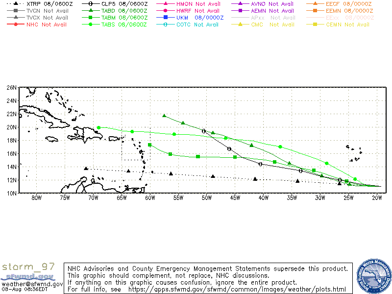
Re: ATL: INVEST 97L - Models
12Z GFS keeps a surface low moving WNW till hour 192 where it shows a weak 1012 low north of 22N.
Then in hour 198 it depicts a low over the Dominican Republic
Made me look..
Dry air weak and west is the usual track.
Then in hour 198 it depicts a low over the Dominican Republic
Made me look..
Dry air weak and west is the usual track.
0 likes
-
captainbarbossa19

- Professional-Met

- Posts: 1094
- Age: 27
- Joined: Wed Aug 21, 2019 11:09 pm
- Location: Beaumont, TX


-
floridasun
- Tropical Storm

- Posts: 245
- Joined: Tue Sep 14, 2021 3:59 pm
Re: ATL: INVEST 97L - Models
we should wait when we closer and 200 hours to see how models look like than
3 likes
-
captainbarbossa19
- Professional-Met
- Posts: 1094
- Age: 27
- Joined: Wed Aug 21, 2019 11:09 pm
- Location: Beaumont, TX
Re: ATL: INVEST 97L - Models
floridasun wrote:we should wait when we closer and 200 hours to see how models look like than
I agree, but my point is that this may not necessarily be an OTS storm. It's too far out and a lot can change in 1 week.
2 likes
-
Blown Away

- S2K Supporter

- Posts: 10253
- Joined: Wed May 26, 2004 6:17 am
Re: ATL: INVEST 97L - Models
Clearly the 12z Euro showed a stall @24N/65W and deepened at @240 hrs. It’s long range, but a winter like trough might be overdone in mid August?
0 likes
Hurricane Eye Experience: David 79, Irene 99, Frances 04, Jeanne 04, Wilma 05… Hurricane Brush Experience: Andrew 92, Erin 95, Floyd 99, Matthew 16, Irma 17, Ian 22, Nicole 22…
-
Spacecoast

- Category 2

- Posts: 773
- Joined: Thu Aug 31, 2017 2:03 pm
ATL: INVEST 97L - Discussion
FSU Genesis prob (12z):

ECMF Genesis (12z):

track density:

GEFS (12Z):

ECMF Genesis (12z):
track density:
GEFS (12Z):
0 likes
Re: ATL: INVEST 97L - Models
Blown Away wrote:Clearly the 12z Euro showed a stall @24N/65W and deepened at @240 hrs. It’s long range, but a winter like trough might be overdone in mid August?
If there is a deepening system stalled north of 24N even a short wave would dig to pick it up.
The shear might keep it from intensifying further but with its forward speed the eastern quadrants could be a threat to Bermuda or the Canadian maritime.
I'm still wondering if it will dry out west of -35W and continue weak and west.
Still forecast to miss the islands and leave them on the weak side of the storm but that could change.
0 likes
Who is online
Users browsing this forum: No registered users and 28 guests